Walk #405: Snowdon Ranger to Caernarfon via Snowdon
 |
 |
|
General Data
| Date Walked | 05/04/2003 |
| County | Gwynedd |
| Start Location | Snowdon Ranger |
| End Location | Caernarfon |
| Start time | 09.08 |
| End time | 17.30 |
| Distance | 16.2 miles |
| Description | This was a walk of two halves; an initial walk up and down Snowdon was followed by a long road walk from the base of he mountain back to Caernarfon. |
| Pack | Today I carried my 30-litre Karrimor HotRock rucksack, which was filled with my packed lunch, waterproof leggings, water bottles (a two-litre and one-litre Platypus) and a couple of spare shirts, together with the usual assortment of odds and ends. |
| Condition | I feel absolutely fine after this walk, and I could easily have walked further if I had needed to. My left knee, which I had been lightly concerned about, gave no trouble, and m ankles held up to the pounding on the rocks quite well. |
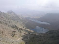
| Weather | Today was a funny old day; as we approached the bottom of Snowdon the top was clear and sunny, and I was in sunshine for the majority of the ascent. However as I reached the place where the Snowdon Ranger track meets the Llanberis track the top started to be covered in mist. Thus by the time that we reached the top there were no views available, but as we descended below this layer we were back into sunshine. To end the day here was lots of fog, which made for a very different end to the day. |
| OS map | Landranger number 115 (Snowdon & surrounding area) |
 |
 |
|
 |
 |
|
Map of the walk
Maps courtesy of Google Maps. Route for indicative purposes only, and may have been plotted after the walk. Please let me have comments on what you think of this new format. For a detailed table of timings for this walk, please see the table file.
 |
Notes
Okay, so I know that Snowdon is not on the coast, but it is so near to the coast that I could not resist the temptation to climb it. Yesterday afternoon I walked from Caernarfon to Snowdon Ranger, so I was ideally placed to climb up it via the Snowdon Ranger route. We spent last night at a campsite which is an hour's drive away from Snowdon Ranger with my sister and her family, so we got up quite early so that we could say goodbye to them before heading off in bright sunshine which boded well for the day.
My plan for the day was to walk up the Snowdon Ranger route to the top of the mountain, and then come back down the Llanberis route to Llanberis. This would give me a nice and varied route over the mountain, which is preferable to going up and down the same route. Sam dropped me off at the car park at Snowdon Ranger and then drove around to Llanberis, as she planned to catch the train up Snowdon as far as the Clogwyn Station, which is as high as the train was going at this time of year, and then walk up to meet me at the top.
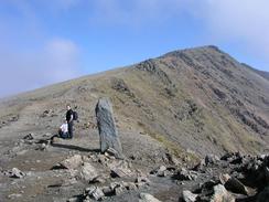
The initial part of the Snowdon Ranger route was quite easy, and I managed to walk up it quite fast, with only one stop of five minutes to eat a couple of bars and admire the view. The path underfoot varies from wide and easy to steep and rocky. It was quite distinct and easy to follow, although I could imagine that in mist it would be easy to get lost on some sections. One thing that surprised me was that on this path I saw only one other person, and he was descending downhill. When I reached the point where the Snowdon Ranger path meets the Llanberis and Pyg tracks I was suddenly inundated with people, most of them coming up the Pyg track. I phoned Sam up and she was not far away, so instead of ascending into the mist I decided to wait for Sam there. As I waited quite a few people passed me, and as I chatted to some of them they gave me donations. It was the ideal place for this, as people were resting there after climbing the Pyg track so it was easy to catch them!
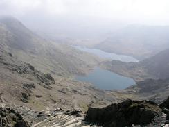
After about twenty minutes Sam arrived, and we set of along the last, easy, walk to the summit. Unfortunately this was in cloud, and so the views were hardly expansive or good. It felt very nice to be at the summit, but after a little rest whilst we chatted to other walkers we started out descent. As we descended we passed many people coming up, some of whom seemed singularly unprepared for the climb, wearing trainers, jeans and t-shirts with no packs. At the top there were some cyclists (apparently this is one of the few days of the year when they are allowed up the mountain), and as we descended they came streaming past us, the wheels of their bikes clunking over the jagged stones on the steepest sections. We came across one man who had come off and gashed his leg slightly, and I was amaze that people would try and cycle down these steep paths.
On the way down Sam started having trouble with her left knee, and as we got further down it got worse and worse until she was very noticeably hobbling at the bottom. I still felt fit, and we walked on a little distance to a hotel in Llanberis where we had a quick drink before we continued on. Someone in the bar told us that there was an old railway line that would save a little walking along the main road, and this was quite helpful. The walk along the road went quite quickly and I soon reached the Welsh Highland Railway Station in Caernarfon, which I had left yesterday afternoon to make my way to the base of Snowdon.
At the station I met Sam, my sister Sue and her husband Peter, and my niece and nephew Katie and Ben. We chatted as we waited for my parents to arrive, and when they did we drove out of the town to go for a meal. It was really nice to be with my family (or at least the majority of it), even if it was only for one evening.
Tomorrow I will walk up towards the Menai Bridge and cross over onto Anglesea. My parents are staying at a campsite on the island, and they say that the scenery is fantastic, so I am very glad that I have made the decision to spend a week walking around it.
Directions
This walk starts off at the Snowdon Ranger car park on the A4085 Caernarfon to Beddgelert road. From here take the Snowdon Ranger path up to the summit of the mountain; I will not give details of the route as there are many different guidebooks describing the routes up the mountain. At the top of the mountain descend using the Llanberis route down to the Llanberis Station of the Snowdon Mountain Railway.
From the station turn left and follow the road northwestwards through the town until it reaches the A4086 road. At the junction cross over the A4086 and turn left along a surfaced road that eventually ends at a cycle path along an old railway trackbed. The path continues for about a mile until it passes through a short tunnel, after which it joins the A4086 once more. Follow the A4086 northwestwards, passing the junction with the A4244 road. I diverted along the local road through Cwm-y-glo before rejoining the A4084, which I the followed all he way into Caernarfon. In the town I passed the castle before making my way to the railway station, where this walk ends.
Distances
| From | To | Distance (m) | Ascent (ft) | Descent (ft) |
|---|---|---|---|---|
| Snowdon Ranger | Snowdon | 3.9 | 3107 | 79 |
| Snowdon | Llanberis | 4.5 | 79 | 3245 |
| Llanberis | Caernarfon | 7.8 | 443 | 771 |
This makes a total distance of 16.2 miles, with 3629 feet of ascent and 4095 feet of descent.
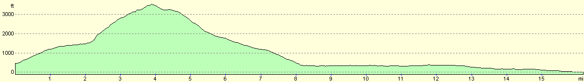
For more information on profiles, ascents and descents, see this page
Accommodation
We parked on the road right outside the Welsh Highland Railway Station in Caernarfon. This was very convenient for the centre of the town and all the facilities, although we did not need to use them.
Disclaimer
Please note that I take no responsibility for anything that may happen when following these directions. If you intend to follow this route, then please use the relevant maps and check the route out before you go out. As always when walking, use common sense and you should be fine.
If you find any information on any of these routes that is inaccurate, or you wish to add anything, then please email me.
All images on this site are © of the author. Any reproduction, retransmissions, or republication of all or part of any document found on this site is expressly prohibited, unless the author has explicitly granted its prior written consent to so reproduce, retransmit, or republish the material. All other rights reserved.
Although this site includes links providing convenient direct access to other Internet sites, I do not endorse, approve, certify or make warranties or representations as to the accuracy of the information on these sites.
And finally, enjoy your walking!
This walk was mentioned in the following routes:
| My walk around the coastline of Britain |
Nearby walks
| # | Title | Walk length (miles) |
|---|---|---|
| 404 | Clynnog Fawr to Snowdon Ranger | 22.8 |
| 406 | Caernarfon to Barras | 17.1 |
| 407 | Barras to Aberffraw | 18.3 |
|
|

|