Walk #330: Aveton Gifford to Noss Mayo
 |
 |
|
General Data
| Date Walked | 18/01/2003 |
| County | Devon |
| Start Location | Aveton Gifford |
| End Location | Noss Mayo |
| Start time | 08.17 |
| End time | 15.51 |
| Distance | 19.1 miles |
| Description | This was a lovely walk, mainly following the South West Coast Path between the Avon and Yealm estuaries and crossing the Ere estuary at low tide. |
| Pack | Today I carried my 30-litre Karrimor HotRock rucksack, which was filled with my packed lunch, waterproof leggings, water bottle and a couple of spare shirts, together with the usual assortment of odds and ends. |
| Condition | I feel slightly fatigued after this walk, but aside from this I have had no problems today. My ankle was fine today and I generally feel very fit - I feel the fittest I have been all my life, and the cold that I have had for a week or so finally looks as if it is going. |
| Weather | The weather today was generally fairly horrible although it did start off well enough, with some sunshine and only a little bit of cloud about. It was fairly windy, however, and by the time that I had crossed the River Erme the wind had also bought heavier cloud over, and it started to rain. It never rained really heavily, but the wind meant that he rain came in horizontally at times and I soon get quite wet. In particular my legs, which had got damp in places fording the river, got cold in the wind and in places never dried out. About an hour before the end of the walk the rain petered out, but it never completely went away and there was still heavy cloud overhead. |
| OS map | Landranger number 202 (Torbay & South Dartmoor, Totnes & Salcombe) and Landranger number 201 (Plymouth & Launceston, Tavistock & Looe) |
 |
 |
|
 |
 |
|
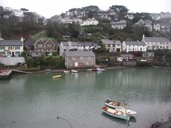
Map of the walk
Maps courtesy of Google Maps. Route for indicative purposes only, and may have been plotted after the walk. Please let me have comments on what you think of this new format. For a detailed table of timings for this walk, please see the table file.
 |
 |
|
 |
Notes
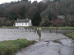
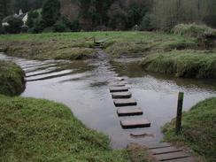
When I had got dressed in the morning I got out of the van to have a look at the state of the tidal road. This was partially covered by water, but by the time I had finished getting ready the water level had retreated, so I decided to attempt to walk along it to avoid having to walk along the longer diversion. This first section was only a few yards along and was about ankle deep, so I went through this section with no problems and got onto the dry road on the other side. Around the next bend however, I came across a creek where the road was deeply flooded and I decided that I could not walk through this. Rather than turn back, I decided to follow a footpath off to the right, and after a hundred yards this led to another footpath leading to the left. This led across the creek on a few stepping stones, the last few of which were under water. I crossed these, and on the other side turned left along a footpath to rejoin a dry section of road. At the end of the tidal road there we another creek, but I could see little waves breaking across the surface of this one so I realised that the water was not deep. I sloshed my way across to the other side, and thus ended an interesting and surprisingly enjoyable little section of walk.
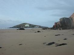
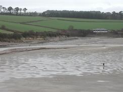
I was in a hurry to reach the River Erme, as I wanted to reach it at about low tide so that I could wade across it, saving a seven-mile diversion around the estuary. I did not know what time low tide was due to be but I did know that when I left the van the tide as going out from a high tide. I hurried along on the first section of path, and when I reached the River Erme I was greeted with a large welcome expanse of sand. I went down onto the estuary floor and started looking for a nice place to cross. There was a lady on the other side of the river who had a couple of golden retrievers, and these were bounding into the water after thrown sticks in one place and getting across without swimming, so I could see that that place was shallow, so with no further ado I strode in. I had my waterproof trousers and gaiters on, and although the water was just under knee-deep I was amazed when I got to the other side and I only had a little dampness in my boots - I had expected them to get soaked. I did not cross at the recommended place, which was slightly further upstream, butt I managed it perfectly well where I did cross, and the bottom had been firm sand, although the current was quite strong. On the other side I found a notice with tide times, and I discovered by some miracle I had crossed the river at 11.44, and low tide was at 11.53! By luck rather than planning I had reached the estuary almost exactly at low tide, which of course id the ideal time to cross.
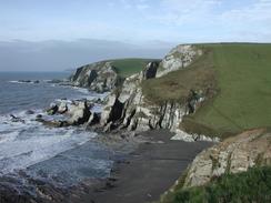
I did not take a break on this walk, except for a minutes stop once I had crossed the River Erme in which I got my sandwiches out of my rucksack. Not having stops on a walk like this places extra strain on my body, but on the first part of the walk I was busy trying to reach the river, and after the river crossing it started to rain and I did not feel like stopping for a rest in that weather. The section of path from Beacon Hill westwards followed the Revelstoke Drive, which was created by Lord Revelstoke in the 1880's as a carriage drive so that gests could be taken on drives wit spectacular cliff top views. he views were not as spectacular today due to the weather, but the drive made for some exceedingly good walking, as it had gentle inclines and descents as it followed the cliff tops. Indeed I think it was one of the easiest long sections of path that I have followed for some time.
The rain really spoilt today - there are many things en route that I would not have minded looking at and exploring for a few minutes, but unfortunately I really did not feel like doing them in the rain. It look as though tomorrow will also be quite wet, so we may stay in a campsite tomorrow night so we can get some clothes dried properly. As of today I have completed over 1,800 miles of the walk, which I a very nice feeling, but I realise that I have over 3,700 miles still to go!
Tonight we went to the local pub, the Ship Inn, for a drink and to use their facilities. As usual we took our collecting tin with us, and we went around and had a large collection. On the way we found a couple of ladies who we spent the rest of the evening talking to, and one of them was a fount of information, and she has given us lots of useful information. Such kindness is very much appreciated, and I would like to thank everyone who donated money tonight.
Directions
| During this walk I followed the South West Coast Path, the route of which is detailed in the Ordnance Survey National Trail Guide 10, Falmouth to Exmouth (ISBN 1-854108-90-5). Unfortunately the route description is written in reverse to the direction that I am walking, but the 1:25,000 maps in the book are clear and the signs on the ground are very good. Also to be recommended is the South West Coast Path Association guidebook (ISBN 0-907055-04-4), which has less concise directions and no maps, but includes accommodation details and grades each section of the walk according to difficulty. They also publish reverse directions, which are suitable for walking in the direction that I walked the route. They have a website at www.swcp.org.uk, which is well worth a visit. | 
|
| 
| |
| |
| |
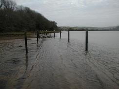
The first part of the walk is from Aveton Gifford to the ferry landing stage and the South West Coast Path in Cockleridge, which with one little exception I walked by following the Avon Estuary Trail. This walk is very well waymarked and the route is detailed in the South West Coast Path Association guidebook, so I will not replicate the directions here. The walk started at the car park beside the roundabout in Aveton Gifford, on the western side of the river. Note should be made of the fact that the first part of the walk south from the car park involves walking along a tidal road, which may be impassable at times (and was nearly impassable when I walked it).
When the ferry landing is reached the South West Coast Path cross over the river, but my route continues on along the road into Noss Mayo, where this walk ends.
Distances
| From | To | Distance (m) | Ascent (ft) | Descent (ft) |
|---|---|---|---|---|
| Aveton Gifford | Cockleridge Ferry Landing | 3.8 | 928 | 922 |
| Cockleridge Ferry Landing | River Erme | 5.6 | 1775 | 1768 |
| River Erme | Noss Mayo | 9.7 | 2087 | 2106 |
This makes a total distance of 19.1 miles, with 4790 feet of ascent and 4796 feet of descent.
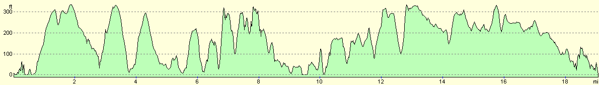
For more information on profiles, ascents and descents, see this page
Accommodation
We parked on the slipway in Noss Mayo, which was handy for the Ship Inn. Sam asked some locals about how far the tide is going to come up tonight, and apparently we are parked high enough so that the tide will not reach us - I can only hope that the locals are correct!
Disclaimer
Please note that I take no responsibility for anything that may happen when following these directions. If you intend to follow this route, then please use the relevant maps and check the route out before you go out. As always when walking, use common sense and you should be fine.
If you find any information on any of these routes that is inaccurate, or you wish to add anything, then please email me.
All images on this site are © of the author. Any reproduction, retransmissions, or republication of all or part of any document found on this site is expressly prohibited, unless the author has explicitly granted its prior written consent to so reproduce, retransmit, or republish the material. All other rights reserved.
Although this site includes links providing convenient direct access to other Internet sites, I do not endorse, approve, certify or make warranties or representations as to the accuracy of the information on these sites.
And finally, enjoy your walking!
This walk was mentioned in the following routes:
| My walk around the coastline of Britain |
| South West Coast Path |
Nearby walks
| # | Title | Walk length (miles) |
|---|---|---|
| 327 | Blackpool Sands to East Portlemouth | 17.7 |
| 328 | East Portlemouth to Salcombe | 12.7 |
| 329 | Salcombe to Aveton Gifford | 15.3 |
|
|

|