Walk #331: Noss Mayo to Turnchapel
 |
 |
|
General Data
| Date Walked | 19/01/2003 |
| County | Devon |
| Start Location | Noss Mayo |
| End Location | Turnchapel |
| Start time | 08.30 |
| End time | 15.16 |
| Distance | 17.0 miles |
| Description | This was another walk of two halves; the initial section comprised of a walk around the River Yealm, and the second part was a walk westwards into the outskirts of Plymouth along the South West Coast Path. |
| Pack | Today I carried my 30-litre Karrimor HotRock rucksack, which was filled with my packed lunch, waterproof leggings, water bottle and a couple of spare shirts, together with the usual assortment of odds and ends. |
| Condition | I feel absolutely fine after this walk, albeit slightly fatigued. I had no major problems, but I had a minor problem with my right knee that was aching at times and buckled unexpectedly on two occasions. |
| Weather | Today's weather was very changeable. It started off sunny with some clouds, but at midday a very dark cloud came over and it started to lash down with rain. This was precisely the time that I reached the South West Coast Path, and the rain was accompanied with a strong wind off the sea that chilled me, particularly as I shaved my beard off yesterday evening. After a little over an hour the rain stopped, and the clouds slowly departed leaving a gloriously sunny afternoon behind them. |
| OS map | Landranger number 202 (Torbay & South Dartmoor, Totnes & Salcombe) and Landranger number 201 (Plymouth & Launceston, Tavistock & Looe) |
 |
 |
|
 |
 |
|
Map of the walk
Maps courtesy of Google Maps. Route for indicative purposes only, and may have been plotted after the walk. Please let me have comments on what you think of this new format. For a detailed table of timings for this walk, please see the table file.
 |
 |
|
 |
 |
|
Notes
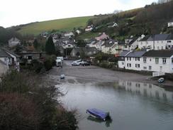
The first part of this walk comprised of a long walk around the River Yealm, which unfortunately mostly consisted of walking along roads (although there were some footpaths), and some of that distance was along the busy A379 road to and through Brixton. This was not a massively enjoyable part of the walk, but at least the roads were not very busy on this Sunday morning, and the weather was quite nice. I find walking along busy roads to be soul-destroying at the best of times, but rain it adds an extra batch of misery and danger that I really do not like. Brixton was quite a nice little village, and a few people enquired about the walk and asked how I was doing, which was quite nice.
Early on in this walk I was walking along the road near Newton Downs, which is to the north of Bridgend, and I saw a queue of about five vans in the middle of the single-lane road. As I got to the front of the queue I could see that a ECSSC Motor X event was taking place, but the entrance to the field was exceedingly muddy and the vans were getting stuck, creating a logjam. A tractor had to pull the vans out of the mud and across the field to their designated positions, and I helped push one particular van out of the mud. If the ground was in this state before any spectators had turned up, I dread to think what it must have been like later on with many cars in the field.
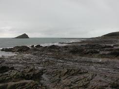
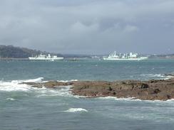
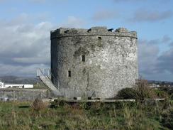
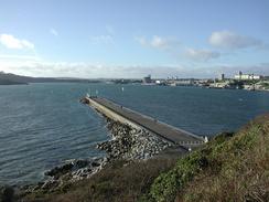
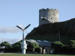
Once I had reached the South West Coast Path at Rocket Cottage above Warren point the going was quite easy, and the path for the rest of the day was relatively flat with no great or steep ascents or descents to tire me out. The views were very nice, and I very much enjoyed getting my first sight of the large Plymouth Breakwater and of two warships that were at anchor near it. I could get a good view of these warships as I walked along, and although I could not identify them they looked impressive beasts. Near Mouth Batten Breakwater I found a list of all the warship movements in and out of Plymouth Sound, and I was amazed at how many movements there were - I was expecting only one or two a week, but there were many more than that, although this was perhaps because the Royal Navy are getting ready for the seemingly inevitable war with Iraq. I tried reading this list to identify the two ships that I had seen, but I still could not manage it. I also enjoyed looking at Fort Bovisard, which the path walks above, as it was yet another of the forts of a similar design to those beside the Thames. It feels like an age ago that I saw those forts, yet it was only about seven weeks ago - I have covered a great deal of distance since then.
Sam had an enjoyable day today - she drove into Holbeton and met Cathie and Ann, whom we met in the pub at Noss Mayo yesterday, so that she could do another collection. She talked to a few horses and their riders, and it sounds as though she really enjoyed herself. I really want Sam to enjoy herself on this trip, and I realise that sometimes I am hard on her (walking like this can shorten my temper), and that she sometimes gets bored and homesick, which I feel really guilty about. I cannot really describe how supportive of me she has been on this trip, and I can only hope that she enjoys herself for the many hours that I am out walking.
By the time that I reached Mount Batten Breakwater I was getting quite tired, and Sam phoned me to see where I wanted to be picked up. I had planned to try and get to over the Laira Bridge, but that was another few miles on and so I decided to cut the walk short and end it at the place where the South West Coast Path ends in Plymouth. This had the added advantage that Sam will not have to drive through the city tomorrow to try and drop me off, and leaves the entire walk through the city to one day. This should be a long slog along roads, and although this will pass through some interesting areas such as Plymouth Hoe I am afraid that it me be a long and boring slog. It also looks as though it will be raining heavily all day, which will make it a doubly dull walk, and if that is the case then I am really not looking forward to the day.
Directions
| During this walk I followed the South West Coast Path, the route of which is detailed in the Ordnance Survey National Trail Guide 10, Falmouth to Exmouth (ISBN 1-854108-90-5). Unfortunately the route description is written in reverse to the direction that I am walking, but the 1:25,000 maps in the book are clear and the signs on the ground are very good. Also to be recommended is the South West Coast Path Association guidebook (ISBN 0-907055-04-4), which has less concise directions and no maps, but includes accommodation details and grades each section of the walk according to difficulty. They also publish reverse directions, which are suitable for walking in the direction that I walked the route. They have a website at www.swcp.org.uk, which is well worth a visit. | 
|
| 
| |
| |
| |
The first part of the walk is around the River Yealm from Noss Mayo on the eastern bank to Warren Point on the western bank. The directions for this section of the walk are detailed in the South West Coast Path Association guidebook, so I will not replicate the directions here. It may be wise to alter these directions slightly to avoid the A379 road, particularly if you are going to be waking along it when traffic may be busy, for instance during the rush hour, as there is along section with no pavements and some nasty bends.
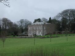
Since I finished the walk, I have been sent details of an alternative route - you can avoid the A379 between Puslinch junction and Brixton by following the north shore of the Yealm Estuary (known locally as the Kitley) from Puslinch Bridge following the old railway line, and then walking up to Fishpond lake, which is below Kitley House. Then head for the small lane that heads north up to Brixton village. There is only one problem in that it is best done at low tide, as one has to negotiate the small stream running out of Fishpond Lake. The land is private but locals have made the walk for many years.
Distances
| From | To | Distance (m) | Ascent (ft) | Descent (ft) |
|---|---|---|---|---|
| Noss Mayo | Warren Point | 9.3 | 1480 | 1476 |
| Warren Point | Turnchapel | 7.7 | 1591 | 1568 |
This makes a total distance of 17.0 miles, with 3071 feet of ascent and 3044 feet of descent.
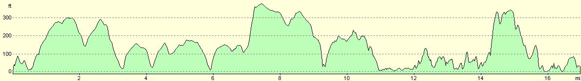
For more information on profiles, ascents and descents, see this page
Accommodation
We spent the night at the Riverside Caravan Park, Longbridge Road, Marsh Mills, Plymouth, Devon PL6 8LD, telephone 01752 344122 and email office@riversidecaravanpark.com. This site cost us eleven pounds for the night including electricity hook-up and the facilities on the site well justified this cost.
Disclaimer
Please note that I take no responsibility for anything that may happen when following these directions. If you intend to follow this route, then please use the relevant maps and check the route out before you go out. As always when walking, use common sense and you should be fine.
If you find any information on any of these routes that is inaccurate, or you wish to add anything, then please email me.
All images on this site are © of the author. Any reproduction, retransmissions, or republication of all or part of any document found on this site is expressly prohibited, unless the author has explicitly granted its prior written consent to so reproduce, retransmit, or republish the material. All other rights reserved.
Although this site includes links providing convenient direct access to other Internet sites, I do not endorse, approve, certify or make warranties or representations as to the accuracy of the information on these sites.
And finally, enjoy your walking!
This walk was mentioned in the following routes:
| My walk around the coastline of Britain |
| South West Coast Path |
Nearby walks
| # | Title | Walk length (miles) |
|---|---|---|
| 330 | Aveton Gifford to Noss Mayo | 19.1 |
| 332 | Turnchapel to Saltash | 12.0 |
| 333 | Saltash to Antony | 17.8 |
|
|

|