Walk #332: Turnchapel to Saltash
 |
 |
|
General Data
| Date Walked | 20/01/2003 |
| County | Devon, Cornwall |
| Start Location | Turnchapel |
| End Location | Saltash |
| Start time | 09.03 |
| End time | 15.28 |
| Distance | 12.0 miles |
| Description | This was a short walk on an eventful day, almost all of which was on roads and was hence hard on my feet. |
| Pack | Today I carried my 30-litre Karrimor HotRock rucksack, which was filled with my packed lunch, waterproof leggings, water bottle and a couple of spare shirts, together with the usual assortment of odds and ends. |
| Condition | I had a little trouble with the underside of my feet, for the first time in ages. This was to be expected, as I washed my new pair of boots last night and by this morning that had not dried out, so I decided to wear my old pair, as this was going to be road walking and waterproofness was not vitally important. When I put them on, however, I noticed that they felt very tight so I decided to take the insoles out. This meant that they were much more comfortable, but by the end of the day my feet were aching and I could feel a hotspot developing. Aside from this I had no other problems, which is to be expected after such a short walk. |
| Weather | During last night and into this morning there was some fairly torrential rain, which actually woke us up during the night. By the time I set off this morning it had stopped and during the morning the cloud lifted and there was some sunshine, but by eleven there was another torrential rain shower. This lasted for about half an hour, and during the afternoon there was more sunshine until after I finished when there was another sharp shower, including some hail. |
| OS map | Landranger number 201 (Plymouth & Launceston, Tavistock & Looe) |
 |
 |
|
 |
 |
|
Map of the walk
Maps courtesy of Google Maps. Route for indicative purposes only, and may have been plotted after the walk. Please let me have comments on what you think of this new format. For a detailed table of timings for this walk, please see the table file.
 |
Notes
I had expected today to consist of a boring plod, but thankfully this turned out not to be the case and I had a rather eventful day. One thing that I liked about the walk through the city was that many of the buildings and structures in the area have a variety of plaques and other items on them. For instance the large wall beside A379 and Pomphlett Lake had a series of poems on the wall, spread out so that they could easily be read whilst walking (although I did note that if you were walking in the opposite direction the poems would be backwards).
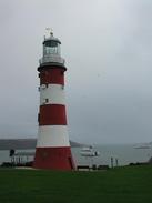
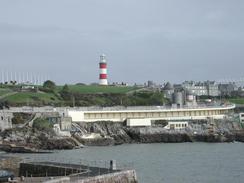
By the time that I reached Plymouth Hoe it had started to rain heavily, and I had a look around Smeatons Tower (the original Eddystone Lighthouse, that was rebuilt on the Hoe) in the rain. There was due to be an article about me in the February issue of Country Walking magazine that was due out today, so I walked from the tower into the city centre to find a WH Smiths where I could buy it. After I had bought it I was skimming through it in the shop when I received a phone call from a local paper, who did an impromptu interview with me on my mobile. They also wanted a photograph, so I suggested that one be taken by Smeatons Tower. The photographer was not available until 12.15, so I had to wait for over an hour, which I filled by going to the hogshead and having a pint. They were also kind enough to allow me to do a collection, and although the pub was not very busy I still managed to collect some money. When the time came I met a nice lady photographer, and we had a chat as she took some photos of me in front of the tower.
Although this delayed me it was a worthwhile delay, and I decided to cut the walk short and walk only as far as Saltash today. As I was walking past the massive DML dockyard buildings I received a phone call from another paper, the Western Morning News, who wanted to send a photographer to get some snaps. Sam had been busy phoning around arranging all these interviews, and she had certainly done a good job! We arranged to meet on the Saltash Bridge, and we spent a few minutes taking photographs on the bridge, where I was crossing from Devon into Cornwall. It has been a rather busy day publicity-wise and this has reduced the distance that I have walked today, but this can only really be seen as being a good thing.
I was surprised by how nice Plymouth was - the centre of the city was very spacious and clean and tidy, which is more than I can say for some cities that I have been through on this walk. I did not get much of an opportunity to explore it but what I did see I liked a great deal.
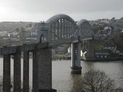
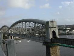
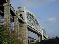
I liked seeing Brunel's Saltash Bridge for the first time. I have always admired the design - it is a combination of suspension and arch, and this allows the bridge to have a long span whilst still giving the height that the Admiralty specified that they required for sailing ships underneath the bridge. The problem that this unusual design solves is simple - with an arch you need supports against the pillars to stop them being pushed out, and with a suspension bridge you need supports (usually the cables being extended to anchor blocks) to stop the pillars being pulled in. By cleverly combining the arch and suspension bridge, the two opposing forces cancel each other out and the bridge sections can be stand-alone. I have always admired this design, and I remember explaining it to my maths teacher when I was at school! The bridge has just had a few million pounds spent on it, extending its life by another twenty-five years.
I actually crossed over the suspension bridge that is beside Brunel's Bridge, over which there is a walkway that pedestrians can use. This bridge has recently been widened, and has had an extra lane built on it - this means that the bridge now has three lanes, one of which is tidal (traffic travels in different directions depending on the time of day). I think this work has spoiled the lines of the bridge slightly, as the walkway has some slightly unsightly bulges in it around the support pillars. The work was done because according to EU law the bridge had to be strengthened to take heavier lorries, and in the process of doing this work they widened it as well. This was my second major suspension bridge of the walk, the first being the Humber bridge near Hull, and I have two more to go - the old Severn Bridge and the fourth will be appropriately enough, the Forth Bridge.
Near the end of the walk I passed Mary Newmans House in Saltash. Mary Newman became the wife of Sir Francis Drake and also the mayoresss of Plymouth in 1580. They married on the fourth of July 1569, when she was seventeen and he was twenty-four, and she died in 1583 from smallpox. The house has been restored by the Tamar Protection Society to provide a snapshot of the way of life at the time when Mary lived in the house, and it is quite attractive from the outside.
Directions
This walk starts off at a car park in Turchapel. The initial instructions are easy as the route follows the extended South West Coast Path through the city as far as the Cremyll Ferry At Admiral's Hard. The route is new and very well waymarked, including one waymarker that is the largest waymarker that I have ever seen.
From Admirals Hard walk north up Cremyll Street until it ends at Durnford Street. Follow Durnford Street northwards for a short distance until a large roundabout is reached. Turn left at this roundabout and cross Stonehouse Bridge and then climb up Devonport Hill, which soon becomes Cumberland Road. This road soon turns to the right and becomes Chapel Street until it reaches a roundabout, over which it becomes Park Avenue.
Continue northwards down Park Avenue until it ends at a T-junction with Albert Road. Turn left down Albert Road for a short distance until it curves sharply to the right beside an entrance to the DML works and becomes Keyham Road. Follow Keyham Road as it heads northwards past the DML works, complete with massive buildings, and becomes Saltash Road before it turns to the right and passes over the railway line before ending at a T-junction with Wolseley Road. Turn left down Wolseley Road and follow it as it heads uphill and passes a railway station on the left.
When Wolseley Road turns left at the station to cross over the line on a bridge continue straight on for a short distance down Trelawney Place until this ends at a T-junction with Pembros Road. Turn left up this road and follow it uphill to a small roundabout by a car park. Head over this roundabout and then turn left to walk over the Tamar suspension bridge using the pedestrian walkway. On the other side of the bride turn left off the walkway and descend down onto Fore Street. Turn left ddown this road and then turn right up Silver Street, passing under the approach viaduct to the railway bridge. At the end of Silver Street turn up Coombe Road past Mary Newman's House. This walk ends a little way along Coombe Road on the left.
Distances
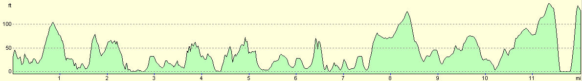
| From | To | Distance (m) | Ascent (ft) | Descent (ft) |
|---|---|---|---|---|
| Turnchapel | Plymouth Hoe | 5.0 | 591 | 577 |
| Plymouth Hoe | Saltash | 7.0 | 797 | 712 |
This makes a total distance of 12.0 miles, with 1388 feet of ascent and 1289 feet of descent.
For more information on profiles, ascents and descents, see this page
Accommodation
Sam had parked the van in Coombe Road in Saltash, which was very near to the Tamar bridges. This was a reasonable place to park, and the street was nice and quiet.
Disclaimer
Please note that I take no responsibility for anything that may happen when following these directions. If you intend to follow this route, then please use the relevant maps and check the route out before you go out. As always when walking, use common sense and you should be fine.
If you find any information on any of these routes that is inaccurate, or you wish to add anything, then please email me.
All images on this site are © of the author. Any reproduction, retransmissions, or republication of all or part of any document found on this site is expressly prohibited, unless the author has explicitly granted its prior written consent to so reproduce, retransmit, or republish the material. All other rights reserved.
Although this site includes links providing convenient direct access to other Internet sites, I do not endorse, approve, certify or make warranties or representations as to the accuracy of the information on these sites.
And finally, enjoy your walking!
This walk was mentioned in the following routes:
| My walk around the coastline of Britain |
| South West Coast Path |
Nearby walks
| # | Title | Walk length (miles) |
|---|---|---|
| 330 | Aveton Gifford to Noss Mayo | 19.1 |
| 331 | Noss Mayo to Turnchapel | 17.0 |
| 333 | Saltash to Antony | 17.8 |
|
|

|