Walk #675: Brechin to Montrose
 |
 |
|
General Data
| Date Walked | 17/05/2005 |
| County | Tayside |
| Start Location | Brechin |
| End Location | Montrose |
| Start time | 09.25 |
| End time | 14.03 |
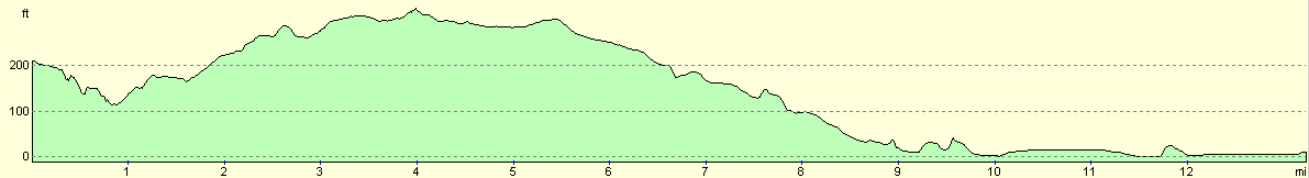
| Distance | 13.3 miles |
| Description | This was a short walk eastwards from the cathedral town of Brechin to the sea at Montrose; a far more entertaining day than yesterday's road-walking marathon. |
| Pack | Today I carried my 70-litre Craghoppers WildPlaces rucksack, filled with full camping gear. |
| Condition | The undersides of my feet ache after this walk, but this is more of a side-effect of yesterday than anything else. Aside from this I feel fine. |
| Weather | The bitterly chilly wind of yesterday was still present, as were the clouds racing overhead. There was a few minutes if drizzle at about eleven, but aside from that it was a dry day. |
| OS map | Landranger number 44 (Ballater, Glen Clova & surrounding area),Landranger number 45 (Stonehaven & Banchory) and Landranger number 54 (Dundee & Montrose, Forfar & Arbroath) |
 |
 |
|
 |
 |
|
Map of the walk
Maps courtesy of Google Maps. Route for indicative purposes only, and may have been plotted after the walk. Please let me have comments on what you think of this new format. For a detailed table of timings for this walk, please see the table file.
| |
 |
|
Notes
Well, it is over. When I have finished other long walking trips I have suffered a surplus off emotions, from the tearful bewilderment of my Fort William to Cape Wrath trip, or the stunned finality of my coast walk, with a year's worth of pent-up emotions being released in an instant on the esplanade at Edinburgh Castle whilst surrounded by well-wishers and ponies. This time, however, as I dipped my boots into the water the only emotions that I had was a feeling of intense satisfaction mixed with a smidgeon of satisfaction at having completed the last twelve days. Montrose beach was a nice place to finish, and whilst I could have picked better places (such as Rattaray Head) it certainly was not a bad place to stop.
The day started off well with a good night's sleep, which I needed after the previous night's unsettled tossing and turning. I knew that I had a short day in store and I was therefore in no hurry to set off - indeed I watched TV and continued reading the book on Hannah Hauxwell after having an early morning shower. Breakfast was nice and, more importantly after my lack of dinner last night, very filling. I then went back upstairs and packed my rucksack up ready to head off, and then carefully lugged it down the stairs and placed it by the door. I was not ready to head of instantly, however; when I had been studying my OS map for the area last night I noticed a trig pillar that I had passed near to and not visited, and as it was only half a mile away I resolved to go back and bag it. There was little point in carrying my rucksack and so I left it at the door whilst I made the short trip.
I soon arrived back and got ready for the main walk of the day. I had another chat with the landlady before I left, and finally in fine mood I set off down the road towards the centre of the town. I had not known much about Brechin, and I was pleasantly surprised to find that it is a pleasant town. I made my way past some attractive buildings towards the Cathedral (again, I had been unaware that Brechin actually had a cathedral). A man was sweeping up the path outside the cathedral, which is a small but nonetheless imposing structure, and then nipped inside for a look around. There was one major thing of note in the area, and that was the adjoining Brechin Cathedral round tower. There are only two round tower in Scotland, (I had visited the other one towards the end of my coastwalk), and it was a fascinating building that hardly seemed wide enough to support a spiral staircase inside it. Unfortunately the lighting conditions were such that I could not get a good photo of it, which is a shame.
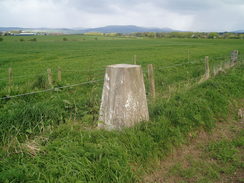
Reluctantly I pulled myself away from the cathedral and continued my walk through the town, heading for the old railway station that is now the home of the preserved Caledonian Railway, which runs the few miles eastwards to Bridge of Dun. This was not operating but I had a quick look over the fence into the railway yard to have a look at some of the stock. After this I started walking along roads, which I would be following for most of the day. At East Pitforthie I diverted northwards along a track for a couple of hundred yards to visit a trig pillar; it amuses me that I have walked all the way across Scotland and only seen three trig pillars; all within the last twenty miles of the coast. This shows exactly how low-level my route has been; in the west of Scotland trig pillars tend to be on the top of mountains, and I had not visited those. More road walking followed eastwards, and there was little of interest for the next few miles, aside from a pair of goats tied up outside the gate of a farm near Damside. I am unsure what they were there for, unless they were guard goats...
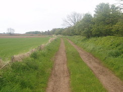
As I walked south along the road past North Dun I saw my first glimpse of the North Sea, the blue of the sea just being visible in the distance below the spire of a church in Brechin. It was a nice moment, and I stopped to look at the target of the last twelve day's walking. To the south of North Dun I had planned to follow a track that headed eastwards near Fordhouse. As soon as I reached the track it started to hail, and although this only lasted for a few minutes it was fairly depressing. The track started off very firm, but it soon became an exceedingly overgrown green lane. Instead of ploughing through the vegetation I decided to skirt alongside the track through the ploughed field to the left, which made for an easier route. Halfway along the lane a grand-looking and seemingly over-engineered bridge led it over a stream, and I soon reached a farm near Langley Park. The farm buildings were grand, although it was a slightly decrepit and faded grandeur, with the buildings in a certain state of disrepair. I could not help but study the detail, before heading on along the track, which was firm once more, as it headed down towards the road at Kirkhill.
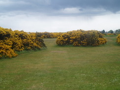
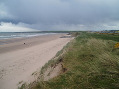
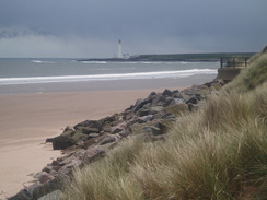
This road led down to the A935, and I had to walk along this busy road eastwards for a couple of miles. Fortunately there was a pavement alongside the road, and so I could walk safely without getting endangered overly by the traffic that roared alongside me. This took me into the outskirts of Montrose, and seeing the town sign proved to be a great moment, as I realised there was only a short distance to go to reach the end of the walk. Once I reached the roundabout by the railway line in the north of Montrose the direct route would only have been a mile to the Park Hotel and the end of the walk, but when I had set off on the walk I had resolved to dip my boots into the North Sea. I therefore followed roads southeastwards, before cutting across a golf course, with the yellow of the flowering gorse bushes contrasting beautifully against the neatly-trimmed grass and blue sky overhead. I crossed the golf course carefully as there were many people playing, and on the other side I climbed the sand dunes to be greeted with an expansive view along the beach. It was a fitting view with which to finish a long-distance walk, and I stood at the top of the dunes, studying the view, with Scurdie Ness lighthouse prominent on the headland to the south.
I stood on top of the dunes watching the waves crash in, trapped in my own thoughts that were tempered with an extreme sense of self-satisfaction. I then jumped down the steep-sided dunes, and walked across the wide beach towards the edge of the water. It was low tide, and it took longer than I expected to reach the edge of the water. Slowly I walked in, allowing the tail-end of spent waves lap against the toes of my boots as I stared longingly out to sea. I could walk no further east, so I skirted along the beach southwards, walking in the surf until the promenade started, and then reluctantly heading inland. It took me longer than expected to walk to the Park Hotel, but when I got there I dumped my rucksack of in the lobby as instructed and went upstairs to where Roger Smith et al were waiting. Another TGO'er was in, just having finished her walk, and we all chatted for a while whilst Roger readied my certificate and t-shirt. It felt strange to have finally finished, and as we chatted I looked back on a satisfying and rewarding stroll across Scotland. After an hour I left, and started to head across the town to my B&B, stopping off at the railway station on the way to investigate the ticket prices for tomorrow.
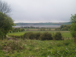
The B&B is very nice, and I was made to feel very welcome. The landlord is a member of the Iron Butt Association as he has ridden a motorbike 1,500 miles in under 24 hours; as such he is one of the few people to do it in Britain. I went out into Montrose in the early evening to get something to eat and a drink, but I was staggered to find that the few pubs I could find were fairly dark and dingy. I ended up settling for fish and chips at a fish and chip shop, and bought a bottle of Old Peculiar from an off-licence, and drunk it in my room. On the way I passed over the entrance to the tidal Montrose Basin. The roadway over it at the moment is temporary as the old concrete bridge is being replaced as it had what is commonly called concrete cancer. The temporary road bridge itself is quite an impressive structure, being built on piles into the riverbed. I enjoyed studying all the machines as I walked past, and looked at the way the old and new structures were constructed.
Directions
This walks starts off at the B&B that I spent the night at on Airlie Street in Brechin. Leave the B&B and turn left to walk sown Airlie Street until it ends at the main road through the town. Turn left and walk eastwards for a few yards, before turning right to head down the High Street; the cathedral is signposted away to the right if you wish to visit it. continue on down the High Street as it becomes Union street, and when this ends at the A935 Southesk Street turn let and walk northwards along that until Park Road leads off to the right. Follow Park road as it heads eastwards past the old railway station (now the base for a preserved railway line), and when this ends at a T-junction turn left to head north along another road, before turning right along another road. This heads in a rough northeasterly direction as it passes through a farm at East Pitforthie, and then head on past Leightonhill until a T-junction with another road is reached at around NO655319.
At the junction turn right and follow another road as it heads southeastwards passing North Mains of Dun. When an track leads off to the left at NO666604 just before a little bridge over a stream, turn let and follow the track as it heads eastwards. The track is initially firm and then becomes overgrown; it then jinks to the right to cross a stream on a bridge before heading down towards some farm buildings. Walk past the buildings and then turn to the left, to follow another track that heads eastwards past Langley Park before curving around to end at a bend in a road near Kirkhill. Turn right and follow this road as it heads southeastwards, crossing an old railway line near Pugeston before ending at a junction with the A935 road.
At the A935 turn let and start following it as it heads eastwards for a little over a mile; the road rises to cross a railway line on a bridge and immediately reaches a roundabout. Continue straight on over the roundabout to head eastwards down Brechin Road, and when this ends at a T-junction with the A92 turn left to head north along it for a few yards before turning right down Broomfield Road. This heads eastwards for a couple of hundred yards before curving to the right to head southeastwards. When the road curves again to the right to head southwards continue straight on along a cycle path, and when a pond and small recreation ground is reached on the left turn left and walk through it eastwards towards the golf course. Carefully cross the golf course, and finally climb up the sand dunes and descend down them onto the beach. Walk south along the beach until the promenade starts on the right; climb up and follow Traill Road, which runs behind the promenade as it curves away to the right away from the sea. Take the first road to the right, Marine Avenue, and follow it as it heads westwards. When this ends continue to head westwards along roads and footpaths, heading up some steps and passing the church before reaching the High Street. At the High Street turn right and head north along it, before turning right down Park Street. Head eastwards along this for a hundred yards until the Park Hotel is reached on the left, where this walk, and the trip, ends.
Distances
| From | To | Distance (m) | Ascent (ft) | Descent (ft) |
|---|---|---|---|---|
| Brechin | North Mains of Dun | 5.9 | 344 | 302 |
| North Mains of Dun | Park Hotel, Montrose | 7.4 | 164 | 407 |
This makes a total distance of 13.3 miles, with 508 feet of ascent and 709 feet of descent.
For more information on profiles, ascents and descents, see this page
Accommodation
I spent he night at the Oaklands B&B, 10 Rossie Island Road, DD10 9NN, telephone (01674) 672018. This nice B&B is located just off A92 to the south of the bridge over the entrance to the Montrose basin.
Disclaimer
Please note that I take no responsibility for anything that may happen when following these directions. If you intend to follow this route, then please use the relevant maps and check the route out before you go out. As always when walking, use common sense and you should be fine.
If you find any information on any of these routes that is inaccurate, or you wish to add anything, then please email me.
All images on this site are © of the author. Any reproduction, retransmissions, or republication of all or part of any document found on this site is expressly prohibited, unless the author has explicitly granted its prior written consent to so reproduce, retransmit, or republish the material. All other rights reserved.
Although this site includes links providing convenient direct access to other Internet sites, I do not endorse, approve, certify or make warranties or representations as to the accuracy of the information on these sites.
And finally, enjoy your walking!
This walk was mentioned in the following routes:
| The Great Outdoors Challenge 2005 |
Nearby walks
| # | Title | Walk length (miles) |
|---|---|---|
| 554 | Stonehaven to Kirkside | 22.0 |
| 555 | Kirkside to Seaton House | 22.1 |
|
|

|