Walk #880: Ventnor to Freshwater Bay
 |
 |
|
General Data
| Date Walked | 20/01/2011 |
| County | Isle of Wight |
| Start Location | Ventnor |
| End Location | Freshwater Bay |
| Start time | 08.43 |
| End time | 16.26 |
| Distance | 19.2 miles |
| Description | This is a stunning walk following the cliffs along the southern edge of the Isle of Wight. |
| Pack | Today I carried my 30-litre Karrimor rucksack, filled with water, my waterproofs, a couple of books and other odds and ends. |
| Condition | I feel very tired after this walk, but have no blisters or other problems. |
| Weather | The day was a mixture of sunshine and cloud, with a bitter northerly wind that chilled me to the core at times. |
| OS map | Landranger number 196 (The Solent & The Isle of Wight, Southampton & Portsmouth) |
 |
 |
|
Map of the walk
Maps courtesy of Google Maps. Route for indicative purposes only, and may have been plotted after the walk. Please let me have comments on what you think of this new format. For a detailed table of timings for this walk, please see the table file.
 |
 |
|
Notes
The forecast for today was for more sunshine, so it seemed like a good idea to go out and do the next stretch of the Isle of Wight coastal path. My legs felt reasonable after yesterday's exertion, so Sencan dropped me off at the RedJet ferry terminal at Southampton before seven in the morning. The journey over to East Cowes was fast, and a bus took me onto Newport and then another to Ventor. This rather convoluted route meant that I only got off at the bus stop a little before nine, a long journey.
I nipped into the co-op near to the bus stop before heading down to the shore, meeting the coastal path where I had left it the previous day. The disadvantage of the clear skies was the cold, frosty morning, the effect of which was accentuated by the brisk northerly wind. It did not seem to have deterred the many dog walkers who seemed to be out in force.
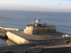
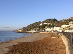
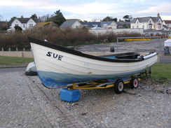
I had not been impressed by Ventnor when I had entered it from the east yesterday; this western side was much better, with a pleasant sandy beach fronted by the promenade. The path soon took me out of the town, diverting through a car park to avoid a path closed by a tiny landslip. A winding walk headed up and down; one stretch of concrete track was slippery with frost. This led down to a promenade that took me to Castle Cove, a superb little spot facing the sea. There was a cafe and a few houses, but nothing too grand or ostentatious.
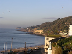
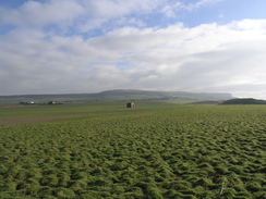
There is something grand about strolling along an easy clifftop path, even when it is trapped between hedges. The smell of the sea can reach even the highest cliffs, and the sound of seagulls can be enticing. For these reasons the next mile of gently rolling path was superb walking. I was on a literal high, my mood soaring with the gulls.
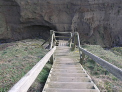
Unfortunately all good things have to come to an end, and I was all too aware that the path would soon climb up the high cliffs to the right. My legs felt stiff after yesterday's walk and I was not looking forward to the climb. Yet it was not as bad as I feared; a slow climb up through St Lawrence took me up much of the way, followed by a steep ascent up some muddy steps. A rock-cut cliff rose to the right at the top of the steps, yet a few steps further on took me out onto a sweeping open hillside.
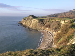
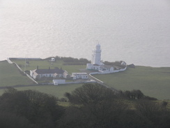
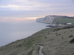
The next couple of miles took me westwards along the edge of the cliffs, with some superb views out to sea. It felt strange to be on cliffs so far from the actual sea, as if the area of land below should really be crashing waves. Ahead and below, the light of St Catherine's Point Lighthouse flashed intermittently. The one problem of this high-level route is that I did not get to visit the lighthouse; I will have to save that for another trip. To my right the vast bulk of St Catherine's Hill rose, with the mast on the top clearly visible. It was a really enjoyable stretch of path, even with the chilling breeze.
The path descended slightly to reach the main road in Niton; the path leading up onto the West Cliff was not easy to find, and I walked down the road a short distance before climbing up and finding the path heading down a driveway. The next stretch of path was also superb, with good views down, especially when the end of the cliffs were reached above Blackgang. Here the views were down over the low cliffs sweeping to the northwest, a stunning vista that unfortunately was hazy.
The path took me down to a car park beside the main road in Blackgang; a stretch of path ran across a field avoiding the road before depositing me onto it. It was surprisingly quiet and reminded me of some parts of Scotland. Another path soon led off through some scrubland, on the way passing some concrete steps that had recently been cleared. A couple of trees grew up beside the steps, the roots snaking over the concrete giving an impression of how long the steps had been covered.
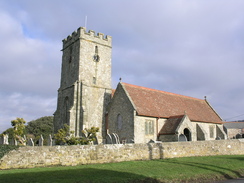
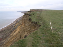
After passing the pretty little church at Chale, the path took me back towards the sea, reaching the coast where Walpen Chine runs into the sea. The chine was deep, and a glance down showed the sea was a surprisingly long way below. Erosion of the soft cliffs on this stretch of coast must occur at quite a rate, and I guess it will not be long until the chine is considerably shorter.
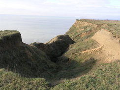
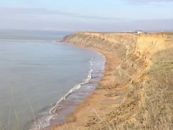
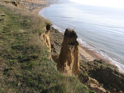
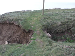
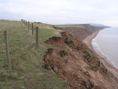
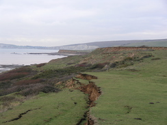
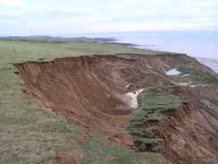
What followed was an exceedingly pleasant walk northwestwards along the edge of the cliffs. The path diverted inland to avoid Whale Chine, but after that it was back to the cliff edge. Again I got a great indication of the fast erosion of the cliffs; cracks in the grass and old paths leading into the abyss. Perhaps the severe winter has led to damage to the cliffs. But I got the impression that the Isle of Wight was at risk of being claimed by the sea. Between the edge of the cliffs and the beach were large areas of slumped land that had once belonged to the cliffs.
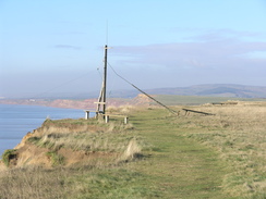
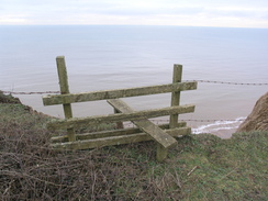
Soon I came across some cottages standing inland, leading me to wonder how long it would be before they to went over the edge, despite being a couple of hundred yards away from the current edge. A post had been set up at the edge, and a wire line led down to a similar post on the fallen land below, presumably a zipline to get things down to the beach below. A seat was beside the post, and I sat down to eat my sandwiches. The wind was still exceptionally cold, and it was not too long before I set off once again.
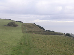
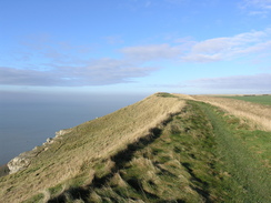
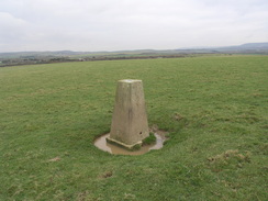
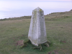
The path diverted down into Shepherd's Chine before climbing up and crossing an area of boggy land around the head of Cowleaze Chine. After this a gently ascent took me to the trig pillar on Barnes High which, despite being a few yards away from the cliff edge, must be living on borrowed time. It really was great walking in the sunshine, the only problem being the fact that the cliff edge had come very close to the fence in places, meaning that I had to either carefully negotiate the edge or clamber over the fence.
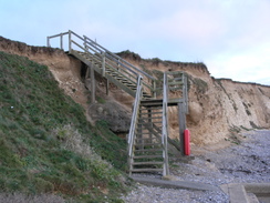
The descent into Marsh Chine lived up to its name, with thick, waterlogged mud on each step. The footbridge at the bottom looked new, and the old one lay like a beached whale nearby. I was feeling more than a little tired by this time, and the short climb up onto the clifftop was not pleasant. A short distance on the path diverted inland past Isle of Wight Pearl and then another chine
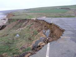
Another couple of miles led me on to Brook Green. A low roofless stone building nearby was the remains of an old lifeboat house, abandoned in 1937. After walking around a short chine I approached a place where the road ran near to the cliffs; too near in fact, and a contraflow was in place as a small chine had eroded right to the road's edge. Some heavy machinery was working a field nearby, probably making a diversion for the road. More work had been done to improve some of the other drainage channels to slow the erosion.
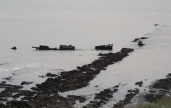
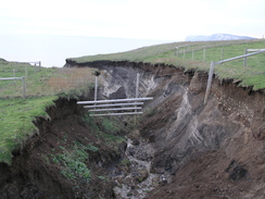
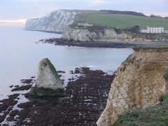
The foreshore in this area was rocky, and the map said it was a fossilised forest. A few black bumps looked as though they might be fossilised tree trunks, but one thing I could identify were the remains of an old boat, the boiler and bow still identifiable on the rocks. A little further on a massive area of land looked as though it had recently slumped down the cliffs, forcing me to climb up higher to get around it. A descent to another chine followed, and the footbridge over the stream felt slightly rickety as one corner was starting to be undermined. Posts hung in mid-air from a fence that had been erected across the chine, a symbol of the eroding banks.
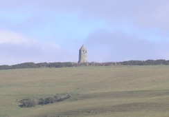
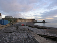
Another climb followed, and this time the path followed the road for part of the way over Freshwater Cliff. It was a good climb, and the views over the chalk cliffs to the west were superb. The path headed away from the road during the descent, passing a monument before reaching the bay below. An infrequent bus service runs from Freshwater Bay to Newport, and the last one of the day was due in about twenty minutes. If I missed it then I would need to walk another couple of miles into Freshwater to get a different bus. Unfortunately I had no idea where the bus stop was, so I walked aimlessly around until I discovered it near the public toilets.
It took me two busses and a ferry reach Southampton once more, giving me plenty of time to reflect on what had been a spectacular day's walk in great (if windy) weather.
 |
 |
|
Directions
In these notes, a 'chine' is a local word for a valley. This walk starts off at the junction of High Street and Pier Street in Ventnor. Head southeastwards down Pier Street; it approaches the top of the cliffs and curves to the right, becoming Shore Hill. As it jinks to the right once more turn left down a path that zigzags downhill before ending at the promenade by the harbour.
Turn right and follow the promenade westwards for a third of a mile beside the beach. When the Spyglass Inn is reached, turn right up a road that climbs above the pub. The road soon turns into a hairpin bend; here continue straight on westwards through a car park. A path starts seawards of the car park; continue on until ;Ventnor' is written in white letters on a bank to the right. Shortly after this turn right up another path that swings to the left and then starts to descend to meet the cliffs once more. Follow the path westwards as it crosses some grass and meets a track at SZ553770. Continue on down this track until it reaches a promenade that can be followed all the way to Castle Cove.
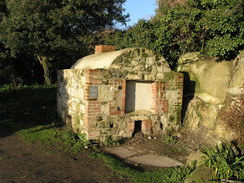
Pass in front of the buildings at the cove until a cafe is reached and then turn right up a path between buildings. It turns to the right before meeting another track; turn left along this to follow a path westwards along the top of the cliffs, passing to the seaward of the Ventnor Botanical Gardens. It leaves the gardens beside an old brick-built incinerator; continue on along a field with a hedge on the right. When the hedge ends continue straight on, aiming for a gap in a hedge that leads to a track.
Follow the track westwards past a house; when it ends continue straight on along a path for three quarters of a mile as it follows the edge of the cliffs. At SZ535761 a track is met; turn right and follow the track northwards. It soon reaches a track by some houses; continue on until the track ends at a T-junction. Turn left to follow a green track across a field; as it curves to the left turn right up another path. This climbs uphill before ending at Woolverton Road in St Lawrence.
Turn left and follow the road westwards; it soon ends at a T-junction. Here turn right up Old Park Road. This curves to the right before ending at the A3055 road. Turn right along this for a few yards, then turn left up Spindlers Road. When this ends at a T-junction with Seven Sisters Road, turn left to climb uphill along this road. The brow of the hill is reached after about a hundred yards; here turn right up a footpath opposite a driveway. The path heads through three and climbs up steps, eventually emerging out onto grassland at SZ530765.
A post marks a junction in the paths; turn left and start following the path westwards along the top of the cliffs. After 1.5 miles at SZ506760 the path curves to the right and starts to descend to meet a track. Turn right along this track, then left to descend down to the A3055 road.
Carefully cross the road and then turn right for a few yards uphill to reach a driveway. Turn left and follow this driveway as it curves to the right and ends; ignore the separate entrances to the house and join a footpath that runs past fields along the edge of the cliffs. SZ489766 is reached after a little over a mile; here the path curves sharply to the right (still following the cliff) to head inland. After a short distance a path heads on to reach a car park.
Go through the car park to the far left-hand corner. Here a footpath leads off to the left, curving around through some scrubland. It emerges out into a field; keep the hedge on the right and follow it around until a gap is reached. Cross a stile to reach the A3055 road. Turn left along the road and follow it downhill to a roundabout; at this turn right (second exit) and continue on northwestwards.. Shortly after the road curves to the right, turn left to join another footpath that heads northwestwards, initially with a fence on the left.
The path curves to the right and enters some woodland as it descends before ending at a road called The Terrace. Turn right down this road for a few yards to reach the A3055. Turn left to follow the road westwards, passing Chale Church on the right. The road curves to the right; when a pub driveway comes in on the right, turn left down a footpath that runs westwards with a stream on the left. After a short distance a plank footbridge leads over the stream; continue on with the stream on the right until the top of the cliffs are reached. Cross another plank footbridge and start following the cliffs northwestwards.
These cliffs are subject to paid erosion, and the directions given below could change if there has been a cliff fall. Care should be taken, as some of the drops are severe. Follow the cliffs northwestwards for just under half a mile, passing the mouth of Walpen Chine; at SZ471780 the path turns to the right to head inland across a field to reach the main road once more.
Turn left and follow the main road northwestwards for a hundred yards. When a car park is reached on the left, turn left to follow the northern bank of Whale Chine back to the cliff edge. Follow the cliffs northwestwards for 1.6 miles until Shepherd's Chine is reached at SZ447797. Turn right and follow the southern bank of the chine for a short distance until steps lead down to the left. Follow these to the bottom of the chine, cross the stream and then turn left to head westwards with the stream on the left.
Take a path that leads up to the right from the mouth of the chine. At the top follow the cliffs northwestwards for a couple of hundred yards to the next chine, then turn right to follow the chine inland until a track is reached at SZ445801. Turn left and follow this track back towards the cliff edge; head through a gap in a hedge on the right to reach the cliff edge once more.
Follow the cliff edge northwestwards for 1.8 miles; it climbs up to the trig pillar on Barnes High before slowly descending to meet Marsh Chine at SZ420816. Some steps lead down to a footbridge at the bottom of the chine. Cross the footbridge and head straight on, passing a couple of static caravans before turning to the right to take an access driveway uphill. As this swings to the left, turn left to rejoin the clifftop path.
Head along the coast for half a mile until a track comes in by hedges at SZ410821. Follow this track up to the main road, and then turn left to follow the main road westwards for about a hundred yards, passing in front of Isle of Wight Pearl. The road crosses a chine; when a car park is reached on the other side turn left and follow a footpath that heads back to the cliff top.
Turn right and follow the cliff top path for 1.6 miles until Brook Green is reached at SZ386834. Here the path leaves the cliffs; turn right, keeping a low ruined building (an old lifeboat hut) on the left. Join a track and follow it up to the main road. Just before the main road is reached turn left to walk parallel to the road until a car park is reached. Take a path that heads from the left-hand side of the car park to rejoin the clifftop path.
Continue on northwestwards along the clifftop path for about 1.5 miles; it passes a fast-eroding car park and then climbs uphill to avoid a large area of slumping. Compton Chine is reached at SZ367851; a stile leads across the fence to access a footbridge over the chine. Cross this, then angle back uphill to another stile that gives access to the clifftop path.
The path climbs up once more, approaching and then running alongside the main road as it climbs. It follows a little bank on the left-hand side of the road until the brow of the head is reached, and then it heads off to the left, descending downhill westwards. It slowly approaches the cliff edge, then runs alongside it as Freshwater Bay is approached. Eventually some steps lead off to the left; take these down to the beach. Follow the beach westwards for a few yards past the lifeboat station, then turn right to head inland to reach Gate Lane opposite a car park. Turn left to follow Gate Lane as it heads inland slightly; the bus stop for the service back to Newport is situated opposite the public toilets.
 |
 |
|
Distances
| From | To | Distance (m) | Ascent (ft) | Descent (ft) |
|---|---|---|---|---|
| Ventnor | Niton | 4.9 | 1047 | 797 |
| Niton | Grange Chine | 8.0 | 974 | 1270 |
| Grange Chine | Freshwater Bay | 6.3 | 896 | 932 |
This makes a total distance of 19.2 miles, with 2917 feet of ascent and 2999 feet of descent.
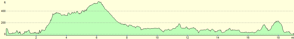
For more information on profiles, ascents and descents, see this page
Transport
It is possible to travel between Freshwater Bay and Ventnor by bus with some difficulty. Southern Vectis route 12 travels every two or three hours from Freshwater Bay to Newport; you will then need to change to the hourly route 3 to get to reach Ventnor. Regular hourly buses on route 7 travels from Freshwater, but the walk from Freshwater Bay to Freshwater would add another couple of miles onto the walk.
 |
 |
|
 |
 |
|
 |
 |
|
 |
 |
|
 |
 |
|
 |
 |
|
 |
 |
|
 |
 |
|
 |
 |
|
 |
 |
|
 |
 |
|
 |
 |
|
 |
 |
|
 |
 |
|
 |
Disclaimer
Please note that I take no responsibility for anything that may happen when following these directions. If you intend to follow this route, then please use the relevant maps and check the route out before you go out. As always when walking, use common sense and you should be fine.
If you find any information on any of these routes that is inaccurate, or you wish to add anything, then please email me.
All images on this site are © of the author. Any reproduction, retransmissions, or republication of all or part of any document found on this site is expressly prohibited, unless the author has explicitly granted its prior written consent to so reproduce, retransmit, or republish the material. All other rights reserved.
Although this site includes links providing convenient direct access to other Internet sites, I do not endorse, approve, certify or make warranties or representations as to the accuracy of the information on these sites.
And finally, enjoy your walking!
Nearby walks
| # | Title | Walk length (miles) |
|---|---|---|
| 310 | Bucklers Hard to Milford on Sea | 19.0 |
| 311 | Milford on Sea to Southbourne | 16.9 |
| 834 | A circular walk from Lymington to Sway | 19.6 |
|
|

|