Walk #881: A circular walk from Yarmouth to the Needles
 |
 |
|
General Data
| Date Walked | 24/01/2011 |
| County | Isle of Wight |
| Start Location | Yarmouth |
| End Location | Yarmouth |
| Start time | 08.32 |
| End time | 15.24 |
| Distance | 18.9 miles |
| Description | This was an exceptionally pleasant walk around the easternmost corner of the Isle of Wight. |
| Pack | Today I carried my 30-litre Karrimor rucksack, filled with water, my waterproofs, a couple of books and other odds and ends. |
| Condition | I feel absolutely fine after this walk. |
| Weather | The day started off generally sunny with a few clouds; a front came over during the day, and it ended up cloudy. There was a chilly northerly wind that was perishing when exposed to it on the high ground. |
| OS map | Landranger number 196 (The Solent & The Isle of Wight, Southampton & Portsmouth) |
 |
 |
|
Map of the walk
Maps courtesy of Google Maps. Route for indicative purposes only, and may have been plotted after the walk. Please let me have comments on what you think of this new format. For a detailed table of timings for this walk, please see the table file.
 |
 |
|
Notes
There was still about 28 miles to go before I completed the Isle of Wight coastal path; too much to do in one day, and too short to make into two decent day walks. A look at the map soon solved the problem - by starting at Yarmouth on the south coast of the island, I could take in the high ridgeline of Compton Down before joining the coastal path and heading towards the Needles. This would make a pleasant circular walk of just under twenty miles, and leave about eighteen to complete the coast between Yarmouth and Cowes.
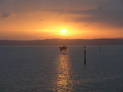
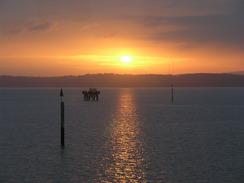
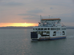
It seemed sensible to use the Lymington to Yarmouth ferry to reach the island; despite being a slower journey, it was cheaper and would require no bus journeys over on the island. The ferry itself was quite nice, as to be expected as the new and controversial ferries on this route only came into service a couple of years ago. I sat at the front of the lounge on the journey over, which gave me a spectacular view of the sun rising over the Isle of Wight ahead of me - a spectacular start to the day.
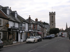
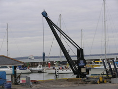
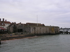
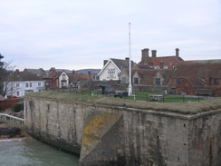
Yarmouth immediately struck me as one of the nicest town I had seen on the whole island. The centre is small, but choc-a-block with old buildings, including a castle right beside the ferry port. Indeed the car ferry itself - hardly a glamorous piece of engineering - seemed modestly subtle against the castle walls and adjacent ferry. I slowly strolled through the town, soaking up the atmosphere of the place. People were strolling around, and no-one seemed to be in any particular hurry, even with the ferry about to depart.
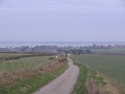
The first few miles of my route were always going to be fairly nondescript, and that was exactly what they turned out to be. My plan to follow the track form the eastern tip of Compton Down meant a long road walk, the first part along a main road. Fortunately it was an Isle of Wight main road, which, like most on the island, is fairly quiet. It ran parallel to the sea out of the town, granting me some views over the Solent, before more roads took me inland.
Soon I was on a single-track road that speared southwestwards across the island. It was narrow but also quiet; at times I could see both the Solent behind me and the rising downs ahead. It was the sort of walk which allows me to put my mind into neutral and just walk - it was hardly a bad walk by any measure despite being along roads. Before I knew it the minor road had ended at a main road, and then a footpath took me up towards the start of the track across Compton Down.
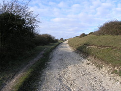
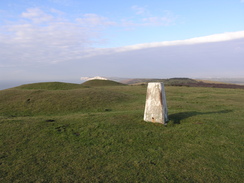
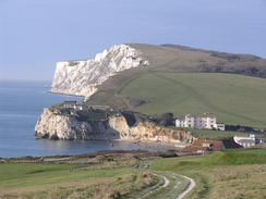
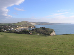
A steep climb took me uphill, the chalk track a broad scar. I diverted off near the top to visit the trig pillar at the eastern end of the down, which nestles amongst a series of barrows called 'five barrows'. I tried to count them, but either came up with four or six, depending on which bumps and hollows you called a barrow. Some had obviously been dug in the past, and resembled more a grassy ring than a mound. My attention was mainly focussed, however, on the views, which were superb. The sun had come out during the road walk, and the white cliffs of Tennyson Down seemed to shine in the sunlight.
The only downside was the stiff northerly breeze, which was chilly. I pulled my woolly hat down firmly over my ears and set off on what was a superb piece of walking along the ridge of the down. The sea sparkled away to my left, beyond the cliffs that I had walked on Thursday. Ahead lay the white cliffs, tantalisingly close. The path slowly descended, becoming a good unsurfaced track as it entered a golf course. A couple of golfers paused their shots as I passed, but aside from them there seemed to be no other players about. There were walkers, however, and far more than I had seen on the rest of the coastal path put together. Even in January the down attracts walkers, and it is easy to see why.
I stopped to talk to one couple who were taking a short break on the island. It was a surprise to see that I had walked over seven miles already, and my legs were feeling fine. As sometimes happens on a walk, I was in the zone for no discernable reason. The euphoria continued as I descended down to meet the coastal path in Freshwater Bay.
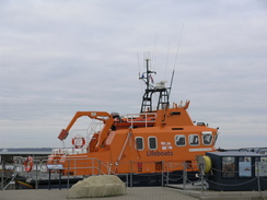
Footings for an extension to the Freshwater Lifeboat building had been dug, and the blockwork was slowly rising out of the ground. The lifeboat itself had been attacked by vandals a few weeks ago; the idiots slashed the boat many times. Fortunately the damage has now been repaired, although I do not believe the culprits have been caught.
The coastal path took me on westwards; I expected the path to head towards Fort Redoubt (once a fort, now a private home) before joining a path along the cliffs. Instead a sign pointed diagonally across a field, avoiding the cliff edge. It was a stiff climb, and I stopped to have a quick chat with a well-equipped man who was testing a route that a band oif scouts were soon going to use on a night-navigation.
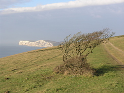
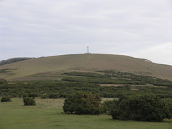
The gradient soon slackened, and what followed was a superb walk up Tennyson Down. The path strayed slightly inland from the cliff edge, and it was easy to follow, especially when the Tennyson monument on the top of the down came into view. Small white pieces of chalk carpeted the thinly-cropped grass like a thin layer of snow; there were no rabbit holes or other holes for it to have come from. I can only assume that it was thrown onto the down by waves crashing against the chalk cliffs, although as I was about 130 metres above sea level the waves must have been exceptionally powerful!
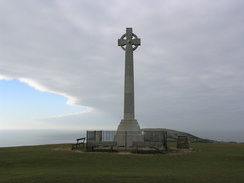
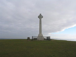
The Tennyson monument at the very top of the down was a slight disappointment; the sun had finally gone behind the clouds as I approached, and it seemed a rather subdued stone cross. In bright sunshine on a warm summer's day it must be a glorious spot; today I just wanted to hunker down out of the wind. It certainly was nowhere near as grand as the Yarborough monument on the opposite side of the island.
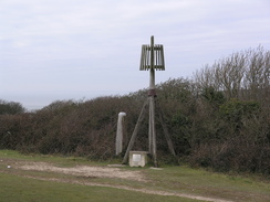
A path led down to a little beallach, at the bottom of which was a classic wooden beacon, the sort that guard harbours all over the country. It seemed a strange place for it to be, as it was high-up on the down and away from the cliff's edge. A plaque at its base told the story: a similar light, the Nodes Beacon, had once stood at the top of the down to act as a light for mariners. It had been dismantled when the Tennyson monument had been built; this half-sized replica had been built in 1977 using some of the original parts. In many ways I preferred the rustic structure to that of the brash Tennyson monument; I could imagine the beacon standing in wind and rain at the top of the down, guiding sailors to a safe harbour.
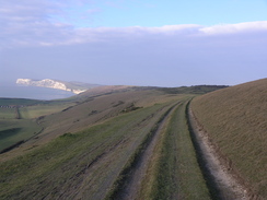
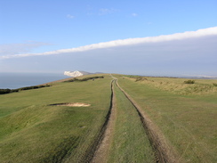
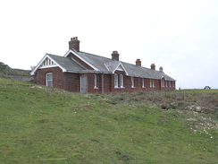
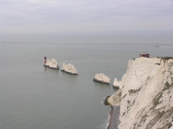
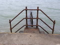
Another gentle climb took me up West High Down, again along grass far away from the edge of the cliffs. The overcast skies means that the chilly breeze was felt all the more, and it was almost a relief when I reached the coastguard cottages at the western end of the down, which meant that I could descend. The down finishes at the world-famous Needles, but much of the promontory is closed off to visitors, guarded by high fences. The coastal path heads back east along the coast, but I wanted to see if I could get a good view of the Needles, which were out of view from the path. Since I was feeling fine it seemed sensible to explore the area for a while.
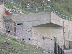
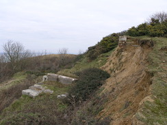
I joined a surfaced toad that headed down past the new fort, heading down to the old fort, now run by the National Trust but sadly closed today. A signpost for a viewpoint pointed uphill along some steps, and I decided to take this. This took me back up to the new fort, and then headed down past the concrete remnants of, strangely for such a beautiful location, a rocket testing site.
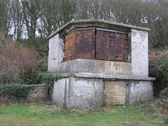
Between 1956 and 1971 the site was used to test Britain's satellite launcher, the Black Knight and Black Arrow rockets. The rockets would be tied down onto the two test stands and fired; the actual launches took off from Woomera in Australia. The concrete remnants of the test stands and buildings were not too obtrusive, and indeed were hardly distinguishable from the new fort above.
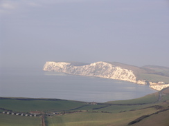
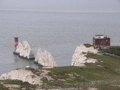
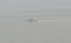
I wandered around for a while before making my way down the steps to the viewpoint. This granted me a superb view over the Needles, with the famous red-and-white striped lighthouse standing prominently at the end, topped with its helicopter landing pad. As if to make the moment perfect, the sun broke momentarily though the clouds as a grey warship sailed past. So many of my interests in one view - spectacular scenery, the sea, rocketry and military hardware. To say the least I was in heaven.
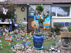
I tore myself away from the view and went to explore the new fort for a while. I love these old fort sites, and find it easy to imagine how they would have looked at the height of wartime. Fortunately few ever saw any use in anger. From there I rejoined the coastal path, which soon joined a road that headed along the northern side of West High Down. I made good time on the road as it angled past a house with an exceptionally colourful garden, and I threw a couple of quid into a wishing well.
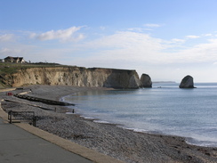
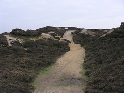
The large car parks of the Alum Bay complex were a little further on, along with many shops, including one that sold sweets; I only just managed to avoid going into this. A chair lift leads from here down the cliffs to the beach below; it seems a surprising place for such a thing, as the beach was narrow and shingle. This touristy urbanism seemed out of place in what had been a splendidly rural and scenic walk, but fortunately it soon improved as a path led me up onto Headon Warren.
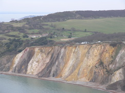
I diverted away slightly to see the old battery site at the warren, which was far more overgrown than the ones I had seen earlier in the day. Indeed two of the six embrasures have fallen over the edge of the cliff. What followed was a superb climb up onto Headon Warren, a great and short stroll along moorland with the sea visible to my left over a series of overgrown landslips. It felt like being on Derbyshire moorland, with the added addition of sea views.
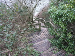
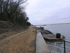
The path stuck with the moorland for as long as possible, before joining a road for a short distance and taking a long flight of steps to reach the foreshore in Totland. A seawall took me on towards the 1880-built Totland pier, which sadly appeared to be in a seriously decayed state, with an ugly-looking security gate halfway along its length. Access is only available from a cafe that was shut. I have heard of many piers being extended out to sea, but Totland Pier was extended the opposite way in 1916 when coastal erosion set the coastline back.
A good promenade took me on around Warden Point and into Colwell, passing a cafe on the way. Here the trail headed inland along a road, and the next mile was a not particularly interesting inland route, including a diversion around an old fort. The coast was originally met once more by Cliff End Battery; along with its neighbours, Fort Albery and Fort Victoria, this guarded the western end of the Solent from attack. The massive Hurst Fort, situated on a spit halfway into the Solent, worked with these batteries to totally close off the Solent to enemy shipping. I have loved Hurst fort ever since I first visited it, and it was great to get some good views of the massive structure from across the water.
Unfortunately these views were few and far between as I was walking through some woodland. Fort Victoria now houses, amongst other things, a planetarium, and signs scattered along the path gave information about the outer planets. I did not get to see the inner planets as my route took me away from the planetarium before dropping me out onto a road.
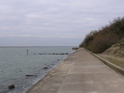
This was not followed for long, as the trail dropped me down onto the foreshore where another seawall was followed eastwards towards Norton Spit. It was a pleasant stroll with some good views over the Solent. A ferry was visible ahead at Yarmouth, and I knew that I would not make that departure in time. This was a good decision as it allowed me to take the last mile at a slower pace, a worthwhile thing as the approach to Yarmouth was a pleasant walk, even though it was along a main road.
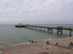
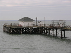
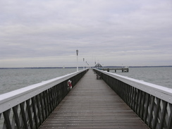
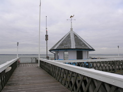
After crossing a swing bridge over the River Yar I approached the port. Most ports are ugly places, with lines of cars waiting in bleak concrete surroundings. Somehow this was not the case in Yarmouth, where the entire port fits very well into the town. I passed the lifeboat and reached the terminal, but there was still a long time to wait for the next ferry. Instead of waiting I walked a short distance through the town to the pier and strolled to its end. Apparently it is the only fully wooden pier still open in Britain. I watched the next ferry come in, before heading back and waiting to board. It had been a superb day's walk, but far my best day on the Isle of Wight.
 |
 |
|
Directions
This walk starts off from the ferry slipway in Yarmouth. Leave the ferry and turn left to walk east along Quay Street. This soon reaches a junction with Pier Street; turn right and follow the road south until it ends at the A3054 road. Turn left and follow the A3054 eastwards for half a mile. It curves to parallel the coast before reaching the B3401 road at SZ363897.
Turn right and follow the B3401 as it twists and turns in a rough southerly direction for about two-thirds of a mile. At SZ366888 follow the road as it curves sharply to the left to head eastwards for half a mile into Thorley. At a crossroads before the church is reached turn right down Hill Place Lane. Initially this road heads southwards, before curving to head in a more southeasterly direction. After two miles it ends at a junction with the B3399 at SZ389859.
Turn left and follow the main road eastwards as it climbs over a shallow hill. At SZ393858 turn right along a bridleway that climbs up over a hill southeastwards for a quarter of a mile. Initially it is muddy, but after cresting the summit it joins a firm farm track before it ends at the B3399 road once more. Turn right to head south uphill for a quarter of a mile until a junction with a series of tracks is reached at SZ395850.
Turn right and start following a chalk track westwards. It soon reaches a junction; turn left to follow the obvious track as it starts to swing to the right with a disused quarry on the right. The path climbs steeply uphill. Near the top you can divert off to the right to visit the trig pillar; if not, simply continue along the track as it heads westwards along the crest of Compton Down for nearly three miles, crossing a gold course on the way. It slowly starts to descend before ending at the A3055 road at SZ350856.
Turn right and follow the main road downhill for a short distance into Freshwater Bay. When the main road road heads off sharply to the right, continue straight on along Gate Lane that parallels the beach; there is a car park on the right. The rest of the day is spent on the Isle of Wight Coastal Path. The road starts to curve away inland; after a short distance some public toilets are reached on the left. Turn left down the track (signposted for Fort Redoubt).
Continue on southwestwards down this track for a short distance until a stile is reached on the right. Cross this, and take an obvious path that heads uphill in a rough westerly direction, aiming for a stile in the upper-left hand corner. Cross the stile and start following a path uphill westwards for nearly a mile, aiming for the Tennyson Monument and staying slightly away from the edge of the cliff.
There is a path that follows the cliff edge from the monument, but the official coastal path heads downhill slightly to the right, aiming for a beallach. It passes a replica of Nodes Beacon at SZ318853 before climbing uphill west-southwestwards onto West High Down. Continue on along the crest of the hill for a little over a mile until a fence is reached near to the coastguard cottages at SZ300847, with a mast on the left and the cottages on the right. Turn right and follow the fence downhill past the cottages until a stile is reached.
Here my route diverted away from the coastal path for a short distance. Cross the stile and turn right to join a surfaced track that heads downhill. Follow it around a hairpin bend and then turn left to head down towards the Needles Old Battery. At the entrance to the battery turn left up some steps. The path immediately curves to the left to head uphill with a fence in close company on the right. It ends in the New Battery. Turn right to follow a road past a coastguard hut; the road curves to the left to reach the site of the rocket test stands. As this is reached turn right to reach the Needles viewpoint. From there, head back up the steps to the track, and follow it round past the coastguard hut to reach the New Fort. Pass through this and cross a stile to reach the coastal path once more.
A footpath angles downhill east-northeastwards; initially the gradient is gradual but it soon becomes steeper as it ends at a surfaced road at SZ302849. Turn right and follow this road as it heads east-northeastwards; after a third of a mile it turns sharply to the left to head northwards. It passes the car park of the Needles Park on the left before reaching a roundabout at SZ308854. Turn right at the roundabout and follow the B3322 eastwards for a couple of hundred yards.
Turn sharp left down a track leading to a golf pitch and putt course. Continue down this lane until a gate is reached; here join a footpath that angles off to the right. This path curves around between hedges, initially to the right and then the left before emerging out onto the site of the old Headon Fort at SZ307857. As soon as you enter the grassy area of the fort turn right along a steep chalk path that leads up onto Headon Warren.
Continue along path eastwards, staying slightly to the north (seaward) of the summit ridge. When the path forks take the left-hand fork and follow it as it passes seaward of Warren Cottage. A good path then descends with the edge of the cliffs close by on the left. The path eventually curves to the right before ending at Cliff Road at SZ319863.
Follow this road as it winds downhill, curving to the left. After a couple of hundred yards a path leads off to the left; head down a slope to reach the top of a long flight of wooden steps that leads down to the foreshore at Widdick Chine. Turn right to join the seawall for a little over a mile; it passes Totland Pier and then curves to the right around Warden Point to reach the end of a road at Colwell Chine at SZ326878.
Turn right up Colwell Chine Road and follow it southeastwards for about a quarter of a mile until it ends at the A3054 road. Turn left and follow the road northeastwards for another quarter of a mile; when the road curves to the right turn left down a track that leads towards Brambles Farm. Continue along the track keeping the farm on the left until a junction in footpaths is reached; here turn right along a footpath that soon curves to the left to enter a holiday park. A few yards into the holiday park turn right to head eastwards up a driveway uphill; it leaves the park and ends at a junction with a lane called Monks Lane at SZ334885.
Turn left and follow the lane downhill north-northwestwards. It approaches the entrance to another holiday park; at the entrance turn right to take a path that follows the park's fence. It curves to the left before reaching a track. Turn right and follow this track northeastwards away from the park. The track enters some woodland; continue along it for about half a mile before it ends at Westhill Lane at SZ341897.
Continue straight on along the lane for about fifty yards; when it curves to the right take a footpath that leads off to the left. After a short distance this ends at a sea wall. Turn right and follow this seawall eastwards for about a quarter of a mile. When some marshland starts on the right, turn right down a track that heads southwards for a few yards before ending at the A3054 road.
Turn left and follow the A3054 in a rough easterly direction for about half a mile, crossing the Yar Bridge on the way. The road enters Yarmouth; turn left to walk through the bus station and at a roundabout turn left down Bridge Lane to head north back to the ferry landing. I extended the walk slightly by following Quay Street eastwards, then turning left to reach Yarmouth Pier. Walk along the pie before retracing your steps to reach the ferry landing.
 |
 |
|
Distances
| From | To | Distance (m) | Ascent (ft) | Descent (ft) |
|---|---|---|---|---|
| Yarmouth | Shalcombe | 4.8 | 472 | 177 |
| Shalcombe | Freshwater Bay | 3.3 | 295 | 584 |
| Freshwater Bay | Totland | 7.5 | 1474 | 1424 |
| Totland | Yarmouth | 3.3 | 151 | 207 |
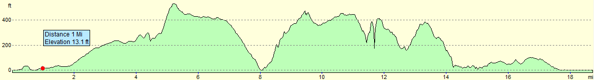
This makes a total distance of 18.9 miles, with 2398 feet of ascent and 2392 feet of descent.
For more information on profiles, ascents and descents, see this page
 |
 |
|
 |
 |
|
 |
 |
|
 |
 |
|
 |
 |
|
 |
 |
|
 |
 |
|
 |
 |
|
 |
 |
|
 |
 |
|
 |
 |
|
 |
 |
|
 |
 |
|
 |
 |
|
 |
 |
|
 |
 |
|
 |
Disclaimer
Please note that I take no responsibility for anything that may happen when following these directions. If you intend to follow this route, then please use the relevant maps and check the route out before you go out. As always when walking, use common sense and you should be fine.
If you find any information on any of these routes that is inaccurate, or you wish to add anything, then please email me.
All images on this site are © of the author. Any reproduction, retransmissions, or republication of all or part of any document found on this site is expressly prohibited, unless the author has explicitly granted its prior written consent to so reproduce, retransmit, or republish the material. All other rights reserved.
Although this site includes links providing convenient direct access to other Internet sites, I do not endorse, approve, certify or make warranties or representations as to the accuracy of the information on these sites.
And finally, enjoy your walking!
Nearby walks
| # | Title | Walk length (miles) |
|---|---|---|
| 310 | Bucklers Hard to Milford on Sea | 19.0 |
| 311 | Milford on Sea to Southbourne | 16.9 |
| 829 | A circular walk from Beaulieu | 20.3 |
|
|

|