Walk #829: A circular walk from Beaulieu
 |
 |
|
General Data
| Date Walked | 07/02/2009 |
| County | Hampshire |
| Start Location | Beaulieu |
| End Location | Beaulieu |
| Start time | 08.06 |
| End time | 15.57 |
| Distance | 20.3 miles |
| Description | This was a very pleasant walk, initially following the Solent Way to Lymington, then circling back across Beaulieu Heath. |
| Pack | Today I carried my 30-litre Karrimor rucksack, filled with waterproofs, a flask and other odds and ends. |
| Condition | I feel absolutely fine after this walk; I have no blisters, and aside from a general fatigue I have no significant problems. |
| Weather | The weather today was a mixture of sunshine and cloud, with very little wind. It was not a warm day, but the lack of wind meant that I could manage with just my fleece on. |
| OS map | Landranger number 196 (The Solent & The Isle of Wight, Southampton & Portsmouth) |
 |
 |
|
 |
 |
|
Map of the walk
Maps courtesy of Google Maps. Route for indicative purposes only, and may have been plotted after the walk. Please let me have comments on what you think of this new format. For a detailed table of timings for this walk, please see the table file.
 |
 |
|
 |
 |
|
Notes
I fancied doing another walk in the New forest, so I planned this walk to take in part of the Solent Way. I remember this stretch of the walk well from my Coastwalk, and I seemed to enjoy it, despite a rather long stretch of road walking. There had been some heavy snow recently, but there was no sign of this as I headed south towards Beaulieu. I was unsure if there was going to be any parking, but in the end I found a large car park.
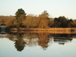
Beaulieu is a fantastic village, a little gem. Instead of heading straight off I walked down to have a look over the Mill Dam, a beautiful spot with Palace House in the background. I then took a path that passed the small fire station and a disguised, brick-fronted second world war pillbox. The path plunged into some woodland before emerging out; considering I had walked this before, I was surprised that I could remember none of it.
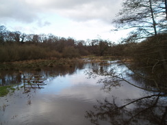
As it went into another patch of woodland there was a sign, stating Bucklers Hard via riverbank. Instead of sticking on the track through the trees I diverted off and followed this path. It was boggy in places, but there were boardwalks carrying the path over the worst patches, There were some good views over the river, and I realised that this was probably going to be the most scenic part of the day. The blue skies overhead made it a superb little walk.
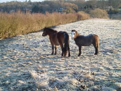
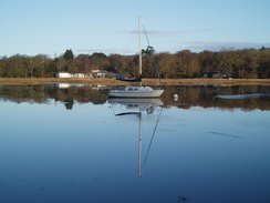
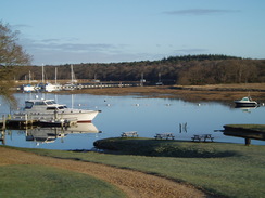
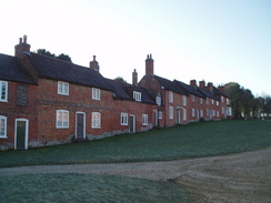
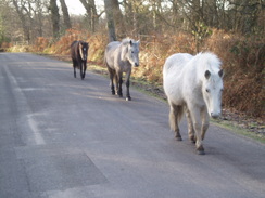
Eventually I reached Bucklers Hard, a shipbuilding site that is now a museum. The two rows of houses leading up from the foreshore were once going to part of a much larger complex, but in the end only these were built. It is a fascinating place, in a beautiful spot. I walked out past the museum and into the car park, then started heading southwards along roads, seeing my first New Forest ponies on the way.
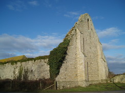
At St Leonards Grange the road curves around the vast gable end wall of an old tithe barn - possibly the largest every built. It is truly a massive structure, and the modern barn built inside it is dwarfed by the older gable end. There is remarkably little information available about it on the Internet - but the eastern gable-end wall is a dominating, prominent and impressive structure.
A short distance on there was a plaque beside the road, marking the site of the old Needs Oar Advanced Landing Ground. This was built during the Second World War, and was the home to 100 Typhoon fighters for a short period until after D-Day. There are no traces left of the airfield or runways now, and the views over the Solent to the Isle of Wight were pleasant; it was hard to believe that there had ever been an airfield there. The road took me westwards; near Thorn Corner Cottages there is a trig pillar marked on the map, and although I could see it through the trees, but I did not bother going into the field to try and find it.
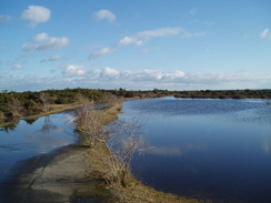
Roads took me on past Sowley Pond, which I could not get very good pictures of, and shortly after this the Solent Way diverted off the road and into fields for about two-thirds of a mile. Considering the last four miles from Bucklers Hard had been on roads, it seems strange that the path chooses to divert off for such a short period, especially when the stretch of path is so undistinguished. Another road took me onwards, and then a complex little series of paths took me past a lake, with Pylewell Park visible in the distance on the left. After this some very boggy stretches were crossed; it was a relief when the path reached a firmer track. Just before a road was reached I saw a curious sight - probably hundreds of small bushes dumped beside the track, dead, their root balls visible.
Shortly after this I was surprised to find another old second-world war airfield, the old Lymington Airfield. This was an Advanced Landing ground in 1944, and was the home of eighty P47D Thunderbolt bombers. Unlike the previous ALG at Needs Oar Point, there was actually traces of this left on the ground; a grass landing strip and a remaining 'blister'-style hanger, along with a militaristic 6-wheel truck outside it.
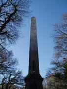
The path led past a golf course, and from here I got views of a tall monument in the distance. I wondered if I would get to pass this as I joined a road, and strove to look for it. I could not see it as I left the road and started to head into a wooded glade, only to be greeted with the sight of the monument stretching into the air from an earthen bank in the middle of the trees. I headed up to this and studied it; the four plaques on each face of the base of the column were difficult to read, but I could make out a little. When I got home I did a search on Wikipedia, and found out that this is the Lymington Obelisk, built to celebrate the life of Sir Harry Burrard Neale.
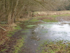
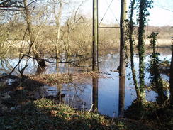
After studying this I descended a steep path down towards the River Lym, and as I walked along the road towards Lymington I was greeted with a very strange sight - several people, including a woman, cycling along in smart clothes; suits, etcetera. I had no idea where they were going, but it looked as though they were having fun! I decided not to head into Lymington and instead headed northwards out of the town, stopping only to shrug my rucksack off to get at my food. A footpath headed off to the right to follow the river northwards and this seemed like a good route; unfortunately, that was not the case. The first warning sign was literally a warning sign, stating that the path floods occasionally, and this literally turned out to be the case as the path was extremely wet underfoot, and in places actually boggy. Off to my right there were trees half-submerged in water, part of the river, and to my left a fence guarding an industrial estate. It was a relief when I found a place that I could leave the path and head back via the roads of the industrial estate. Here I saw a heavily-beaten up Porsche on the back of a low-loader, the obvious victim of a crash.
I stopped off at the red Lion pub in Boldre for a while so that I could have a drink and a rest, both of which were badly needed by this time. Although I had taken my boots off, I still felt rather self-conscious sitting there with my muddy trousers on. After I left a road took me down to a bridge over the river, and then a steep bridleway headed uphill. This crossed a road and continued onwards across pasture and bands of woodland, eventually reaching Dilton Farm. Here I had a slight problem; I had to join a new footpath that would take me eastwards, and the ground on the other side of the stile was muddy, having been churned up by cattle. In the end I decided just to for it, and a combination of careful route planning and speed (if not grace) saw me safely over it.
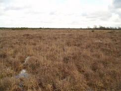
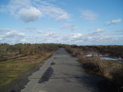
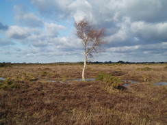
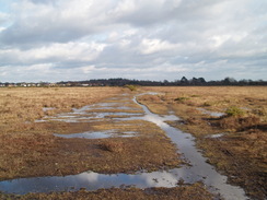
The path was boggy all the way to the stile that led into Beaulieu Heath, and what followed was a wonderful but wet walk. Some gorse was in flower, but this was left behind as I aimed for the old runways of the old < href="http://en.wikipedia.org/wiki/RAF_Beaulieu" target="_blank">Beaulieu airfield, the third Second-world war airfield that I had passed today! The going across the rough ground was not too easy, and it was therefore a slight relief when I finally reached the old perimeter track of the airfield. This had mostly been robbed out, but I made good time around the northwestern and northeastern stretches of the old track. These were very wet in places with large puddles from one side to the other, but nothing that I couldn't handle - besides, my trousers were already wet.
At the eastern end of the airfield there is a stretch of the old runway that is used for flying model aircraft; no-one was flying as I passed, but a family were flying a large kite shaped like a dragon. After this the track became rougher, and I soon reached the B3054 road that bisects the moor. I followed this for a short distance, then started to take a series of paths across Bagshot Moor. Surprisingly, this is another old airfield; the East Boldre Airfield, first used as an aerodrome in 1910. It is hard to believe on the ground that there was once an airfield here; it looked just like any other stretch of heathland in the area. Apparently the only remaining building from the airfield is a brick structure, now part of East Boldre village hall, which I passed as soon as I reached the road.
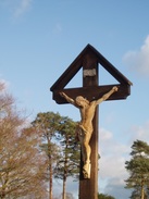
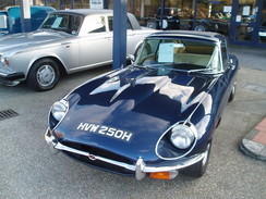
I resisted the temptation to go into the Turfcutters Arms for a drink, and instead took a series of roads back to Beaulieu. On the way I passed the Beaulieu cemetery, a smart-looking place with a lovely cross outside it. After this I just put my head down in an attempt to finish the walk; it was roads the entire way, and fortunately they were not too busy. Beaulieu was busier than it had been in the morning, and I stopped off to have a look at a Jaguar E-Type outside the garage in the village before returning to my car.
 |
 |
|
 |
 |
|
Directions
This walk starts off at the car park in the centre of the little village of Beaulieu. Leave the car park and then turn right, to head down towards the Mill Pond. The road curves around to the left; just after the Montagu Arms Hotel on the right, turn right down Fire Station Lane. From here, the walk follows the Solent Way for about ten miles. The lane becomes narrower until it eventually becomes a path that heads uphill before entering Keeping Copse. The path is very well signposted and it would be hard to get lost. However, shortly after entering the copse I turned off left along a footpath that was signposted to Bucklers Hard via the river. This was a long, looping walk, some of which was along board walks, and gave god views over the river in places. It is far better (although muddier) than staying on the track through the woods.
The path rejoins the track near to a little boat store; as the path leaves the Copse it joins another track that heads south past some moored boats to the marina at Bucklers Hard. Cross the marina access road and turn half-left down a footpath that heads for a hundred yards to the riverbank. Turn right along the riverbank along the path and then when some buildings are reached on the right turn uphill. When the houses on the left finish turn to the left and pass the museum. Go through the gate by the entrance into the museum complex, then pass through to the car park.
Turn right to walk through the car park, then turn right Leave the car park and join the access road that ends at a bend in a public road. Turn left and follow a road southwards. This curves to the right to head westwards for about a hundred yards before it ends at a T-junction. Here turn left to follow a road south for nearly half a mile towards St Leonards. Follow the road as it turns sharply to the right beside a large and imposing stone gable end wall of St Leonard's Barn.
The road then heads in a roughly westerly direction, passing the entrance to the Log House and the site of the short-lived Needs Oar Point airfield. Shortly after a road leads off to the right at Thorns Corner Cottages take a road to the left, signposted Sowley Lane, that heads southwards before turning southwestards towards Sowley House.
From Sowley House the road passes to the south of Sowley Pond. Carry on westwards for a few hundred yards, then turn left to follow the Solent Way as it crosses a stile into a field on the left. Initially this skirts the edge of the field with the hedge on the left, before turning to the right to follow the hedge as it heads northwards towards an area of woodland called Sowley Brooms. When the edge of the trees are reached, turn left to walk westwards with the trees on the right. This continues on for half a mile, passing through a narrow band of trees before ending at a road.
Continue straight on along westwards along this road for about a hundred yards; when it curves sharply to the right, continue straight on along a track. This becomes a footpath that heads on westwards, passing a lake called Dod's Pond on the left, then a cricket ground. The path crosses a track leading down to Pylewell House, then continues on towards a band of trees. At the trees turn half-right to walk northwestwards with the trees on the left; after a short distance turn left through the trees and join a rough track that heads slightly south of west-southwestwards before it ends at Shotts Lane.
Turn right and follow the lane northwards; after a quarter of a mile it reaches a crossroads. Continue straight on for another hundred yards, then turn left along a track. This heads westwards across the site of the old Lymington airfield; it then passes Spooks Farm before reaching another road. Turn left down this road for a few yards, then turn right to join a footpath that descends down to the southwest. It skirts the southern edge of a golf course, then ends at a lane. Turn right along this lane for a hundred yards; when it turns to the right, turn left down another footpath. This passes by the Lymington Monument, the drops down to meet a road in Walhampton. Turn right to head north along this road with the river on the left; then at a road junction turn left to head westwards across the river. The pavement is in the other (northern) side of the road, so care is needed.
Follow this road as it crosses a level crossing over the railway line, then reaches a roundabout with the B3054 road in Lymington. Here the Solent Way is left behind. Turn right and head northwards up the road for a third of a mile, then turn right to join a footpath. Initially this crosses the railway line on a pedestrian crossing, then climbs over some large steel flood defences. On the other side turn left, and start following the railway line northwards. Note that apparently this stretch of path often floods. Soon the path curves away from the railway line to the right and heads along a narrow strip of land with flooded scrubland on the right and a business park on the left. When this meets the end of a track, turn left, then join a road that leads westwards through the estate. When this ends at a T-junction directly next to the railway line, turn right to walk northwards for a short distance to a roundabout on the A337.
Turn right at the roundabout, then immediately take a road that leads off to the right. Follow this for 0.8 miles as it heads northwards before ending at a road junction near the Red Lion pub in Boldre. Turn right and follow a road northeastwards downhill to cross the River Lymington. At a road junction on the other side of the river turn left and Rodlease Road northwards. After a third of a mile a footpath leads off at a left-hand bend; turn right up this footpath, and follow it as it starts to climb uphill, with a nursery on the left. The path becomes a track that ends at Church Lane after a third of a mile.
Cross Church Lane, and on the other side continue straight on north-northeastwards along a track for 1.2 miles. This passes Haywards Farm before entering a band of trees and curving half-right to head northeastwards. Just before the track curves to the left to enter Dilton Farm, turn right along a footpath. Cross a stile and start heading eastwards, with the hedge to the left. After a fifth of a mile, cross a stile and enter Beaulieu Heath.
from here, the next third of a mile is trackless; just head eastwards across the heath; cross a faint track at one stage, but continue on until you reach the perimeter track of the old Beaulieu Heath airfield. Once on this, turn left and start following it northeastwards. After 0.7 miles it curves to the right, and starts heading southeastwards. At the eastern end of the old runway, follow the track as it curves to the right once more, than after a hundred yards turn left down the access road that leads to the B3054 road. Turn left to walk northeastwards up this rode for a couple of hundred yards, then, at three posts planted in the ground, turn right down a vague track onto Bagshot Moor.
Continue along until the gorse bushes on the left end, then turn left down an indistinct path that heads eastwards across the moor. Eventually this turns slightly to the left, before ending at a road opposite the post office in East Boldre. Turn right to head southeastwards down this road; pass a pub on the right, then at a junction turn left down Cripple Gate Lane. Follow this eastwards for two-thirds of a mile; at a triangular junction, turn left along another road.
This road heads northwards, curving past Beaulieu cemetery and after two-thirds of a mile reaches another junction. Turn left and follow a road that curves around northwards, passing Beufre Farm, then climbs over Bunkers Hill. After half a mile it ends at the B3054 road. Turn right along the B3054 road, and when this soon curves to the left, continue straight on down a lane that heads northwards through Beaulieu and ends at a road by the Montagu Arms Hotel. Turn left here, then left once more to reach the car park where this walk ends.
Distances
| From | To | Distance (m) | Ascent (ft) | Descent (ft) |
|---|---|---|---|---|
| Beaulieu | Bucklers Hard | 2.8 | 157 | 128 |
| Bucklers Hard | Lymington | 7.9 | 240 | 266 |
| Lymington | Beaulieu | 9.6 | 292 | 295 |
This makes a total distance of 20.3 miles, with 689 feet of ascent and 689 feet of descent.
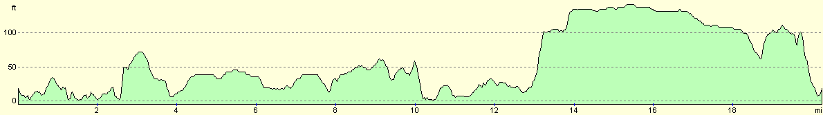
For more information on profiles, ascents and descents, see this page
 |
 |
|
 |
 |
|
 |
 |
|
Disclaimer
Please note that I take no responsibility for anything that may happen when following these directions. If you intend to follow this route, then please use the relevant maps and check the route out before you go out. As always when walking, use common sense and you should be fine.
If you find any information on any of these routes that is inaccurate, or you wish to add anything, then please email me.
All images on this site are © of the author. Any reproduction, retransmissions, or republication of all or part of any document found on this site is expressly prohibited, unless the author has explicitly granted its prior written consent to so reproduce, retransmit, or republish the material. All other rights reserved.
Although this site includes links providing convenient direct access to other Internet sites, I do not endorse, approve, certify or make warranties or representations as to the accuracy of the information on these sites.
And finally, enjoy your walking!
Nearby walks
| # | Title | Walk length (miles) |
|---|---|---|
| 306 | Browndown to Bursledon | 12.9 |
| 307 | Bursledon to Southampton | 9.2 |
| 308 | Southampton to Fawley | 16.4 |
|
|

|