Walk #561: St Andrews to Pittenweem
 |
 |
|
General Data
| Date Walked | 19/09/2003 |
| County | Fife |
| Start Location | St Andrews |
| End Location | Pittenweem |
| Start time | 09.30 |
| End time | 17.34 |
| Distance | 19.2 miles |
| Description | This was a lovely and entertaining walk following the Fife Coastal Path. |
| Pack | Today I carried my 30-litre Karrimor HotRock rucksack, which was filled with my packed lunch, waterproof leggings, water bottle and a couple of spare shirts, together with the usual assortment of odds and ends. |
| Condition | I feel absolutely fine after this walk, and I have no significant problems to report. |
| Weather | Today was mostly sunny, although there were significant periods of cloud. The little wind that there was blew warm, and there was no sign of any rain. |
| OS map | Landranger number 59 (St Andrews, Kirkcaldy & Glenrothes) |
 |
 |
|
 |
 |
|
Map of the walk
Maps courtesy of Google Maps. Route for indicative purposes only, and may have been plotted after the walk. Please let me have comments on what you think of this new format. For a detailed table of timings for this walk, please see the table file.
Notes
I found it hard to wake up first thing this morning, and it took a couple of coffees just to be awake enough to switch on the PC and start doing some work. Sam soon got up to join me, and hence I did not get quite as much work done as I had wanted.
The Fife Coastal Path runs right past the campsite, but as soon as I reached the gate that leads to the path I came across the first problem - a notice stating that the path was closed due to a landslip at the eastern end of the campsite. I decided not to join the path and instead walked through the campsite to the eastern end, where indeed there was a landslip that had taken the path with it. It was simplicity itself to divert around this, however, and I was soon on the path proper.
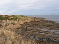
Over the least few weeks I have mainly been walking along relatively flat terrain, and I found the initial stretch of the path to test my legs as it ascended and descended steeply. To make matters worse, in many places the path had been reinforced with uneven stone blocks that were very slippy after the heavy overnight rain; on one descent that had been stepped with these stones I nearly slipped, which could have led to a nasty fall. It was nice to be on some decent cliffs, however, even if they were not particularly grand, and it made a nice change form all the endless beach walking that I have done recently.
Because of the terrain I found that I was not making as good time as I had wanted, and I was only making two and a half miles an hour instead of my usual three. That does not seem like a big difference, but over a few hours walking it can add to a long delay to the walk. One of the good things about being on the coastal path was that navigation was easy; the path was very well signposted and the only time that I went off the path was when I purposefully went across the mouth of Kenly Water, which was possible as the tide was out; this saved me the diversion inland via Boarhills.
During the course of the walk I passed many golf courses, all of which were bustling with people. The one at Kingsbarn was particularly busy as they were getting ready to hold the Dunhill Links Championship here between the 22nd and the 27th. Golf is hardly my favourite sport and I have had some uneasy encounters with golfers whilst walking in the past, but the ones that I met today were very nice, and some even gave me donations for the charity. Past Kingsbarn the terrain became flatter and the path was easier, and the only problems were several shoreline diversions; as the tide was out these were simple.
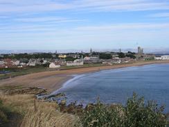
I soon found myself at Fife Ness, where I was looking forward to seeing the lighthouse. Unfortunately it was probably the strangest and ugliest lighthouse that I have seen on the trip; it is housed in a low, single-storey building that is dwarfed by the coastguard buildings that are clustered around it. This was a disappointment, as I would not have minded seeing a tall, elegant lighthouse. The only good thing about Fife Ness was that I got to see Bass Rock in the distance; I had not seen this rock since the first week of the walk, and it was an obvious sign that the walk is coming to an end. I continued on, and soon found myself in the pretty little village of Crail, where I found Sam and my parents waiting for me. I sat down for a very late lunch, before heading off once again.
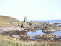
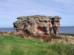
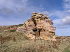
The walk between Crail and Anstruther was the best part of the entire day, and the going along the path was easy. I passed the spectacular rock formations at Caiplie Caves, where the rocks looked as though someone had taken a spoon to them and carved large holes. The caves are apparently decorated with carved crosses dating from the dawn of Christianity, carved by monks and pilgrims on their way to St Andrews. Local children now try and throw stones through a hole in the cliff, which apparently makes a wish come true. It was one of the most spectacular cliff formations that I have seen recently, but I did not enter any of the holes due to large warning signs that dotted the area.
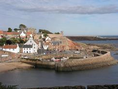
Anstruther was an exceptionally long village that has been split into two parts, Anstruther Easter and Anstruther Wester. There are two harbours in the village, both of which are pretty and worth a visit. Indeed, I must admit that Anstruther, and particularly Anstruther Wester, is a beautiful village - not a title I bestow frequently. I stopped to chat to two ladies near the harbour at Anstruther Wester about the walk, and it was nice to get some colourful local information and stories from them. The final part of the walk took me to Pittenweem past yet another golf course and a strange tower, which looked as though it may have been a war memorial of some description. Pittenweem itself is a nice village, although I did not stop to have a look around it as I was quite tired and very ready for the end of the day.
We spent the evening at a campsite in Lundin Links, where my parents were also staying. We had some lovely fish and chip and a couple of beers, which helped to make me even more tired than I already was, and so I went to bed shortly after nine. There had been a magnificent sunset where the entire south coast of the Firth of Forth had glowed orange; a beautiful sight.
For more details of the Fife Coastal Path, have a look at Bill's Fife Coastal Pathwebpages, the Official Fife Coastal Path pages, or Another good site.
Directions
Most of this walk follows the Fife Coastal Path, which is well waymarked and easy to follow. Leaflets describing the route are available from local tourist information offices. The only place that I did not follow the path was at Kenly Water, where instead of diverting inland to Boarhills to cross the river I crossed it at it's mouth as the tide was low. Also note that some of this path is tidal in nature and cannot be followed at high tides.
Distances
| From | To | Distance (m) | Ascent (ft) | Descent (ft) |
|---|---|---|---|---|
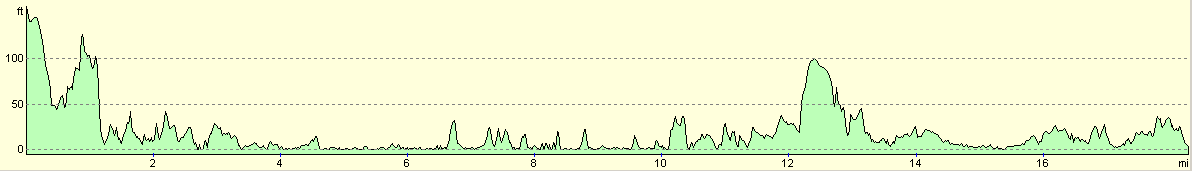
| Campsite near St Andrews | Fife Ness | 10.4 | 840 | 997 |
| Fife Ness | Crail | 2.4 | 253 | 161 |
| Crail | Pittenweem | 6.4 | 282 | 374 |
This makes a total distance of 19.2 miles, with 1375 feet of ascent and 1532 feet of descent.
For more information on profiles, ascents and descents, see this page
Accommodation
We spent the night at Woodland Gardens Caravan and Camping Site, Blindwell Road, Lundin Links, By Leven, Fife KY8 5QG. They can be contacted on (01333) 360319, and they have a website at www.woodland-gardens.co.uk. The site is absolutely lovely with nice and clean facilities, and it cost us ten pounds for the night.
Disclaimer
Please note that I take no responsibility for anything that may happen when following these directions. If you intend to follow this route, then please use the relevant maps and check the route out before you go out. As always when walking, use common sense and you should be fine.
If you find any information on any of these routes that is inaccurate, or you wish to add anything, then please email me.
All images on this site are © of the author. Any reproduction, retransmissions, or republication of all or part of any document found on this site is expressly prohibited, unless the author has explicitly granted its prior written consent to so reproduce, retransmit, or republish the material. All other rights reserved.
Although this site includes links providing convenient direct access to other Internet sites, I do not endorse, approve, certify or make warranties or representations as to the accuracy of the information on these sites.
And finally, enjoy your walking!
This walk was mentioned in the following routes:
| My walk around the coastline of Britain |
Nearby walks
| # | Title | Walk length (miles) |
|---|---|---|
| 560 | Tayport to St Andrews | 20.6 |
|
|

|