Walk #562: Pittenweem to East Wemyss
 |
 |
|
General Data
| Date Walked | 21/09/2003 |
| County | Fife |
| Start Location | Pittenweem |
| End Location | East Wemyss |
| Start time | 09.43 |
| End time | 17.44 |
| Distance | 18.4 miles |
| Description | This was a highly enjoyable walk, the highlight of which was a climb along the chain path at Elie. |
| Pack | Today I carried my 30-litre Karrimor HotRock rucksack, which was filled with my packed lunch, waterproof leggings, water bottle and a couple of spare shirts, together with the usual assortment of odds and ends. |
| Condition | My upper legs are slightly sore after the chain walk, but aside from this I had no problems. I find it quite strange that even after walking for a year I should still get stiff legs, but I daresay that the chain walk used muscles in my upper legs that I do not normally use in walking. |
| Weather | After yesterday's rain today started off fogy, with not much visibility. By eight most of this had lifted, being replaced with a blue sky and not many clouds. As the day went on the clouds slowly gathered and the skies became greyer, although fortunately the rain did not start until after I had finished the walk. |
| OS map | Landranger number 59 (St Andrews, Kirkcaldy & Glenrothes) |
 |
 |
|
 |
 |
|
Map of the walk
Maps courtesy of Google Maps. Route for indicative purposes only, and may have been plotted after the walk. Please let me have comments on what you think of this new format. For a detailed table of timings for this walk, please see the table file.
Notes
When I woke up yesterday to the sound of rain hitting the roof of Mervan, and a look out of the window confirmed that it was a very grey day. I had four days in hand, or two if I walk around the Firth of Forth, and so I decided that give the weather taking a day off would not matter. In the morning I did some work on the website, and in the afternoon my parents, Sam and myself went out to ScotlandÆs Secret Bunker, a 1950's nuclear bunker where Scotland was going to be run from if there was a nuclear war. It was fascinating to look around the place, and it was quite an enjoyable day. After this we all went to Anstruther for a look around the lovely village, and we had a meal at a nice if smoky restaurant.
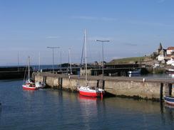
It was thus in a much relaxed state that I got ready for today's walk. Dad gave me a lift to the start of the walk in Pittenweem, and I took a few photographs of the area around the harbour before setting off. The initial stretch of the walk took me to St Monans, and just before I reached the village I passed an old windmill (with sails that were more replica than working), below which were the remains of old salt pans. These were where sea water was evaporated to make salt, thirty-two tons of water and six to eight tons of coal were needed to make one ton of salt, with egg white or bull's blood being used to remove impurities.
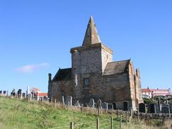
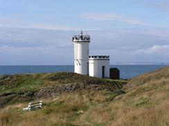
St Monans was a nice little village, and he area around the harbour was particularly nice. I had not been expecting this string of pretty fishing villages down this coast, and they have been a very pleasant surprise. The path southwestwards out of the village passes past a lovely church (thought to be one of the oldest churches still in use in Scotland) before hugging the edge of the cliffs past the 15th century remains of Newark Castle to the cylindrical ruins of the Lady's Tower. This was built for Lady Janet Anstruther in around 1760 as a summerhouse to allow her to bathe nude in the sea! Sadly there were no ladies bathing in the nude today, so I just walked on to the lighthouse a short distance away on the next promontory and into Elie and Earlsferry, where Sam met me for the walk to the chain walk, which we were both considering doing.
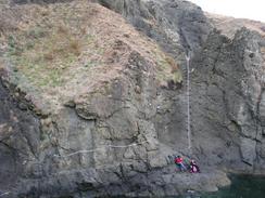
I had been looking forward to doing the Elie chain walk since I first head about it, and I had seen some pictures of it in various books. These did not prepare me for the walk, however; a little scramble around a headland led me to the first chain, which led horizontally along the cliff face into an inlet, with the sea crashing in below. There were little steps in the face below the chain, barely deep enough to get the toes of my boots in. When Sam saw the chain she decided that it was not for her, and she was worried about my doing it. I did consider doing it without my rucksack, but decided that this would be wimping out! The path continued on, going up eighteen to twenty feet at a time, with toeholds that, particularly on the descents were hard to see, with the chain helping pull me up and down. I met two ladies after a while who gave generous donations, and took a photograph of me on the climb, for which I had to go back up a rock face and pose for the camera.
By the time that I emerged at the other side of the chain walk I was elated but my upper legs were very tired, and the muscles were aching in a way that they had not for months. One little ascent was followed by a gentle descent down to Shell Bay, from where the going for the rest of the day was much flatter and easier, which was good as my legs wre slightly wobbly! I met Sam in a car park in Lower Largo, where she had some sandwiches waiting for me. The rest came in handy, although it was a very late lunch. Much refreshed I set off once again, and instantly missed the statue of Lower Largo's most famous son, Alexander Selkirk. He was born in 1676 and became William Defoe's inspiration for Robinson Crusoe after he got abandoned on Juan Fernandez Island off the coast of Chile for four years.
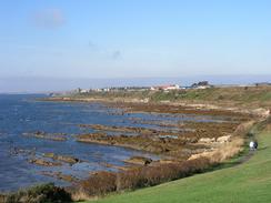
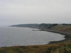
There was a nice stretch of beach from Lundin Links southwestwards to Leven, and from here the route followed roads to Buckhaven through what were some fairly dreary and depressed streets. The Kaeverner oil and gas construction plant dominated Methil, and even the power station in Leven was shut down and slowly decaying, with the rail tracks that once delivered coal to the plant rusting and slowly becoming overgrown. From Buckhaven, however, a path descended down onto a pebble foreshore, and I followed this southwestward to East Wemyss. There is supposed to be a path running above the foreshore, but although it was present in places for long stretches, in many others it has been eroded away and I was forced to walk along the foreshore. Towards East Wemyss I passed a series of caves in the old red sandstone cliffs that have Celtic and prehistoric wall carvings in them. One of these caves is right below the ruins of Macduff's Castle, which I climbed up to take some photographs of.
The place that we chose to park for the night in East Wemyss is not particularly nice, but it does have some lovely views over the Firth of Forth. It was too hazy to see Edinburgh during the daylight, but once it got dark it was easy to see the lights of the city on the other side of the Forth. The lighthouse on Inchkeith could also be seen flashing way, and an oilrig waiting to go to Kaeverner's yard in Methil was lit up like a Christmas tree. There is not far to go now until the end of the walk, and it seems amazing to see the lights of my destination glittering away, and I still have six days to go!
For more details of the Fife Coastal Path, have a look at Bill's Fife Coastal Pathwebpages, the Official Fife Coastal Path pages, or Another good site.
Directions
Most of this walk follows the Fife Coastal Path, which is well waymarked and easy to follow. Leaflets describing the route are available from local tourist information offices. The only places that I did not follow the path was between Earlsferry and Shell Bay, where instead of following the path over the top of the cliffs I followed the Chain Walk, which skirts dramatically around the base of the cliffs past Kincraig Point. Additionally, I followed beaches in a few places.
Distances
| From | To | Distance (m) | Ascent (ft) | Descent (ft) |
|---|---|---|---|---|
| Pittenweem | Elie | 5.0 | 387 | 354 |
| Elie | Lower Largo | 5.9 | 361 | 374 |
| Lower Largo | East Wemyss | 7.5 | 161 | 184 |
This makes a total distance of 18.4 miles, with 909 feet of ascent and 912 feet of descent.
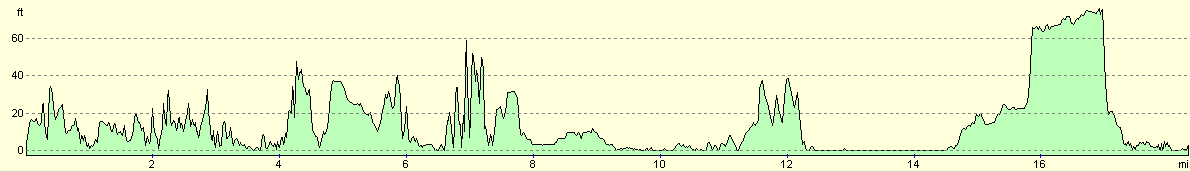
For more information on profiles, ascents and descents, see this page
Accommodation
We parked for the night in a car park by the sea in the centre of East Wemyss, which was a nice enough place to spend he night although there were no facilities nearby.
Disclaimer
Please note that I take no responsibility for anything that may happen when following these directions. If you intend to follow this route, then please use the relevant maps and check the route out before you go out. As always when walking, use common sense and you should be fine.
If you find any information on any of these routes that is inaccurate, or you wish to add anything, then please email me.
All images on this site are © of the author. Any reproduction, retransmissions, or republication of all or part of any document found on this site is expressly prohibited, unless the author has explicitly granted its prior written consent to so reproduce, retransmit, or republish the material. All other rights reserved.
Although this site includes links providing convenient direct access to other Internet sites, I do not endorse, approve, certify or make warranties or representations as to the accuracy of the information on these sites.
And finally, enjoy your walking!
This walk was mentioned in the following routes:
| My walk around the coastline of Britain |
Nearby walks
| # | Title | Walk length (miles) |
|---|---|---|
| 561 | St Andrews to Pittenweem | 19.2 |
|
|

|