Walk #563: East Wemyss to Aberdour
 |
 |
|
General Data
| Date Walked | 22/09/2003 |
| County | Fife |
| Start Location | East Wemyss |
| End Location | Aberdour |
| Start time | 09.11 |
| End time | 15.20 |
| Distance | 14.6 miles |
| Description | This was the shortest day's walk for some time, and although it was not as nice a walk as it was yesterday it was a pleasant enough walk. |
| Pack | Today I carried my 30-litre Karrimor HotRock rucksack, which was filled with my packed lunch, waterproof leggings, water bottle and a couple of spare shirts, together with the usual assortment of odds and ends. |
| Condition | I feel absolutely fine after this short walk, and I could easily have walked further. My upper legs were surprisingly stiff after yesterday, but this was not enough to bother me. |
| Weather | Today was very much a day of sunshine and showers, and fortunately the sunshine was much more frequent than the showers, although these were heavy at times. There was a fair breeze at times, and when combined with the rain this could be annoying. |
| OS map | Landranger number 59 (St Andrews, Kirkcaldy & Glenrothes) and Landranger number 66 (Edinburgh, Penicuik & North Berwick) |
 |
 |
|
 |
Map of the walk
Maps courtesy of Google Maps. Route for indicative purposes only, and may have been plotted after the walk. Please let me have comments on what you think of this new format. For a detailed table of timings for this walk, please see the table file.
Notes
The superb qualities of the Fife Coastal Path over the last few days paled slightly today, as the countryside was left behind somewhat and I entered far more built-up areas. For this reason I was not particularly keen to set off this morning, and I delayed as long as possible. To make matters worse the weather did not look too promising, and so it was with a heavy heart that I gpt ready to set out. Sam could sense that there was something wrong, and I was being far less communicative than I normally am, but however hard she tried she could not improve my mood. This in turn made me feel bad, and I was sorely tempted to take a day off. The lure of the walk was great, however, and so I finally left Mervan and set out on the walk.
A quick climb took me up onto the top of the low cliff and I followed these southwestwards past Wemyss Castle (which unfortunately I could not photograph due to the trees on the cliffs) and on to West Wemyss, which was a well-kept place, with some nice houses near the shore. Southwest of the village I passed the remains of an old colliery that was now being landscaped, and the only remaining feature of it was a winding-gear tower, painted in red undercoat. There was still much room for improvement in the surrounding area, however, as it looked quite unkempt.
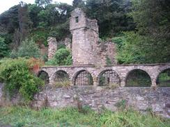
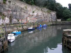
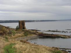
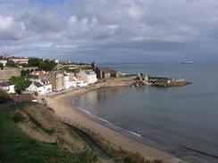
The area around Dysart Harbour was superb, and I stole the time for a quick look around it. A little tunnel took me through a headland by the pier and on into Ravenscraig park. The park was nice enough, but it soon ended and I joined a main road that took me past Ravenscraig Castle. The busy road was more than a little culture shock, and it was with profound relief that I reached the promenade that runs alongside the seafront south from the harbour, which itself was the worst example I had seen on the east coast of Scotland - it was dirty, decrepit and looked very much uncared for. The promenade was better, although I was still relieved when I finally reached the south of the town and could start walking along paths once more. These took me past the ruins of the Seafield Tower, once part of a 16th century manor and now quite a dramatic ruin.
The Fife Coastal Path does not follow the coast around to the harbour as there is no way back up the cliffs to the main road, and instead cuts inland to the A921. By this time I was getting quite hungry, and so when I found a caravan site on the right just outside Kinghorn I went in to order a meal. The restaurant was quite posh and I felt slightly out of place, but when Sam arrived I felt better. From the windows of the restaurant I could look across the Firth of Forth to Arthur's Seat, and using my ocular I could even make out people on Salisbury Crags! The view made me feel slightly strange knowing that the end was so near, but I also found it hard to drag myself away.
After a lovely meal I followed the Fife Coastal Path westwards into and through the town of Burntisland. In the town I lost the path slightly, and had to find my own way through the town past the docks and numerous tower blocks to get back to the path by a factory that was being demolished. The path then ran alongside the railway line - initially on the landward side and later the seaward, passing the bridge over the Starley Burn, the rocks behind which are covered in lime. This makes quite a spectacular effect, and it is a shame that I could not get a good photograph of it.
I found Sam waiting for me in the car park just to the east of Aberdour, and I found myself very much in two minds about what to do. On one hand I had walked a very short day and I could easily extend it, but on the other there was little point in doing this as I had reached my target for the day, and with only five days walking left I do not have far to go. In the end I decided to have a short day, and spend some time with Sam in the afternoon for once. I feel like a bit of a cad as less than fifteen miles is a ludicrously short day and I had been hoping to finish the walk with a flourish and twenty-mile days, but that would see me walking nearly to Glasgow and back!
The end of the trip is now ridiculously close, with Edinburgh seemingly just at spitting distance over the Firth of Forth. The sight of the Forth Rail Bridge has had exactly the same effect that it always does, despite the fact that it is a long way away - the scale of the structure is magnificent, and the shape of the three cantilevered piers are strangely graceful for such a large metal construction. I have dreamed of seeing it since I left Edinburgh at the start of the trip, and the first sight of it took my breath away. It is going to be massively difficult to get back to reality after this trip, and the sight of the bridge is another sign that the time is getting nearer.
For more details of the Fife Coastal Path, have a look at Bill's Fife Coastal Pathwebpages, the Official Fife Coastal Path pages, or Another good site.
Directions
This walk follows the Fife Coastal Path, which is generally well waymarked and easy to follow. Leaflets describing the route are available from local tourist information offices.
Distances
| From | To | Distance (m) | Ascent (ft) | Descent (ft) |
|---|---|---|---|---|
| East Wemyss | Kirkcaldy | 5.5 | 499 | 499 |
| Kirkcaldy | Burntisland | 6.4 | 604 | 577 |
| Burntisland | Aberdour | 2.7 | 315 | 276 |
This makes a total distance of 14.6 miles, with 1418 feet of ascent and 1352 feet of descent.
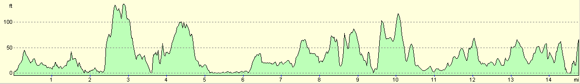
For more information on profiles, ascents and descents, see this page
Accommodation
We parked for the night in a car park just to the northwest of Hawkcraig Point to the east of Aberdour. This was a reasonable place to spend the night, and was quiet enough although there were no facilities.
Disclaimer
Please note that I take no responsibility for anything that may happen when following these directions. If you intend to follow this route, then please use the relevant maps and check the route out before you go out. As always when walking, use common sense and you should be fine.
If you find any information on any of these routes that is inaccurate, or you wish to add anything, then please email me.
All images on this site are © of the author. Any reproduction, retransmissions, or republication of all or part of any document found on this site is expressly prohibited, unless the author has explicitly granted its prior written consent to so reproduce, retransmit, or republish the material. All other rights reserved.
Although this site includes links providing convenient direct access to other Internet sites, I do not endorse, approve, certify or make warranties or representations as to the accuracy of the information on these sites.
And finally, enjoy your walking!
This walk was mentioned in the following routes:
| My walk around the coastline of Britain |
Nearby walks
| # | Title | Walk length (miles) |
|---|---|---|
| 115 | Edinburgh to Dunfermline | 17.4 |
| 222 | Edinburgh Castle to Seton Sands | 14.0 |
| 562 | Pittenweem to East Wemyss | 18.4 |
|
|

|