Walk #564: Aberdour to Culross
 |
 |
|
General Data
| Date Walked | 23/09/2003 |
| County | Fife |
| Start Location | Aberdour |
| End Location | Culross |
| Start time | 09.00 |
| End time | 17.42 |
| Distance | 22.0 miles |
| Description | This was a nice and long stroll, all along roads and well surfaced cycle paths along the northern side of the Firth of Forth. |
| Pack | Today I carried my 30-litre Karrimor HotRock rucksack, which was filled with my packed lunch, waterproof leggings, water bottle and a couple of spare shirts, together with the usual assortment of odds and ends. |
| Condition | I feel absolutely fine after this walk, and I could easily have walked further if I had needed to after a little rest. My upper legs did not ache as much as they did yesterday, which is quite a relief. |
| Weather | Today was mostly a sunny day, with only occasional clouds. The morning was cold and it remained chilly all day, especially when exposed to the slight wind. I wore my fleece all day, and I was glad that there was no rain. |
| OS map | Landranger number 65 (Falkirk & Linlithgow, Dunfermline) |
 |
 |
|
 |
Map of the walk
Maps courtesy of Google Maps. Route for indicative purposes only, and may have been plotted after the walk. Please let me have comments on what you think of this new format. For a detailed table of timings for this walk, please see the table file.
Notes
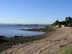
This was a much longer walk after yesterday's short stroll, and for most of the time the scenery was not as nice. The first nine miles followed the Fife Coastal Path, and this should have made navigation easy. When I woke up the sun was shining and it looked as though it was going to be a nice day for a walk. Aberdour was quite a nice little village, and I had a quick look around it before starting the walk along the racks that led southwestwards from the village. These led to the cavernous ruins of an old church by Dalgety Bay, and the path was easy to follow westwards around Dalgety Bay to St Davids Harbour and East Ness.
As I approached Inverkeithing, however, things went slightly wrong; the Fife Coastal Path markers became less frequent and at one particular junction I had no idea where to go. The OS map shows the path running between the paper mill on the banks of Inner Bay and a freight-only railway line. When I did find a marker for the path it led me through a side street to the Mercat Cross in Inverkeithing, which is a lovely little market cross. It felt strange being in Inverkeithing - I had last been there in 2000 during a walk from Kirk Yetholm to Crieff on the trip where I met Sam, and I really had not expected to be there on this trip. I walked south down the B981 road through the town, all the time knowing that the path was marked as being on the seaward side of the railway line. Eventually between two viaducts carrying the main-line railway over the road I found another path marker that headed past a large scrapyard to a quarry by West Ness at the mouth of Inner Bay.
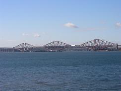
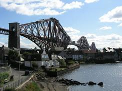
Sam was waiting for me in the car park of Deep Sea world, which is right underneath the magnificent red girders of the Forth Railway Bridge. We wanted to have something to eat so we decided to go to the restaurant in the attraction. Unfortunately we found that the restaurant was only accessible to people who have brought a full ticket, and whilst Sam was going to have a look around later I was not going to spend eight pounds only to gain access to a restaurant! with regret we therefore left and went up the road to the Ferrybridge Hotel in North Queensferry. The food here was fantastic, and I had the largest lamb shank that I have ever seen - great value and it is much to be recommended.
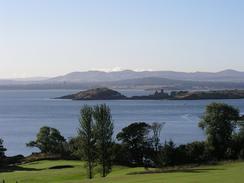
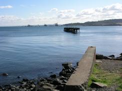
I love the Forth Rail bridge - the structure is fantastic and I enjoyed looking up at it as I walked past. I soon reached the Forth Road Bridge, a massive graceful suspension bridge that could not be more different to the adjacent rail bridge, yet in a strange way the two complement each other more than they should. After this I had a long road plod westwards inland from the northern coast of the Forth, passing the naval base at Rosyth. I was glad when I got off the road and could take a path that headed to Limekilns and Charlestown. From Charlestown I had planned to walk along the coast to Torryburn, but as I got closer I could see that was not practical - a series of large buildings and even a road that were not marked on the map blocked he way, all guarded by a high security fence, obviously part of the Rosyth naval base. Therefore instead of following the cast I had to divert inland to the A985(T) to Crombie and then down a road to the attractive tiny hamlet at Crombie Point.
A nice path then led northwestwards alongside the shore up to Torryburn, and I could then follow roads westwards to Culross past some massive settling ponds that have subsumed Preston Island. Sam was waiting for me in a car park on the western side of the village, and this meant that I had to walk through it. The village is exceptionally pretty, and I enjoyed my stroll as I went through it, looking at the cobbled streets and historic houses as I did so. I did not go up to have a look at the most historic buildings, the Abbey and the Palace, which is a shame as I later found out that they are well worth visiting.
Today is the third anniversary of myself and Sam meeting, and so we had a little celebration with a bottle of wine. It seems good that we are near Edinburgh for the anniversary, as we met in the centre of the city, indeed just down the Royal Mile from where the walk will be ending on Saturday. I love Sam dearly, and the last three years with her have undoubtedly been the happiest of my life.
For more details of the Fife Coastal Path, have a look at Bill's Fife Coastal Pathwebpages, the Official Fife Coastal Path pages, or Another good site.
Directions
The first part of this walk (as far as North Queensferry) follows the Fife Coastal Path, which is generally well waymarked and easy to follow. Leaflets describing the route are available from local tourist information offices.
In North Queensferry join the B981 road and follow this as it heads under the Forth road bridge and then curves to head northwards for about a kilometre. The road passes over a freight-only railway line and then reaches a roundabout; at this roundabout turn left towards another roundabout, and then continue on westwards along a road. This road curves to head northwestwards past some oil tanks and then nears Rosyth.
Continue straight on at a roundabout and follow the road until it reaches another roundabout by a barracks, and then turn right for a few yards until the A985(T) road is reached. At the A985(T) turn left and follow it westwards for a short distance before taking a cycle path that heads downhill to the south towards the Forth, before turning to the right to head westwards into the village of Limekilns near Bruce Haven.
When the path ends at a a road in Limekilns follow the roads past the harbour and on to a T-junction, At the junction turn left and follow a road westwards along the shore and on into Charlestown. The road curves to the right to head inland for a short distance before curving to the left and then the right, to head north for a little under a kilometre until it ends at the A985(T).
Turn left and follow the A985(T) westwards for a little over a kilometre; there is a good path beside the road, and then turn left down a minor road to head into Crombie. Follow this road as it curves through the village to rejoin the A985(T) once more, and then turn left along the road for a few hundred yards until a road leads off to the left.
Follow this road for a mile until it ends at Crombie Point, and then turn right along a track that skirts the shore northwestwards until it ends at the B9037 road in Torryburn. Turn left and follow the B9037 road westwards through Newmills, and then turn left along a road that heads through Low Valleyfield towards Culross. This walk ends in a car park beside a railway line on the western side of Culross.
Distances
| From | To | Distance (m) | Ascent (ft) | Descent (ft) |
|---|---|---|---|---|
| Aberdour | Inverkeithing | 6.4 | 673 | 656 |
| Inverkeithing | North Queensferry | 2.6 | 243 | 308 |
| North Queensferry | Charlestown | 5.9 | 646 | 581 |
| Charlestown | Culross | 7.1 | 292 | 367 |
This makes a total distance of 22.0 miles, with 1854 feet of ascent and 1912 feet of descent.
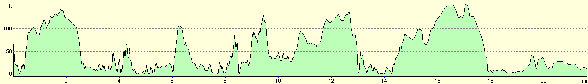
For more information on profiles, ascents and descents, see this page
Accommodation
We spent the night parked in a car park on the western side of the village of Culross. This was right beside the railway line and the northern side of the Firth, but as the line was freight-only it was not in the last noisy. At the end of the car park nearest the village there were some public toilets, which came in handy.
Disclaimer
Please note that I take no responsibility for anything that may happen when following these directions. If you intend to follow this route, then please use the relevant maps and check the route out before you go out. As always when walking, use common sense and you should be fine.
If you find any information on any of these routes that is inaccurate, or you wish to add anything, then please email me.
All images on this site are © of the author. Any reproduction, retransmissions, or republication of all or part of any document found on this site is expressly prohibited, unless the author has explicitly granted its prior written consent to so reproduce, retransmit, or republish the material. All other rights reserved.
Although this site includes links providing convenient direct access to other Internet sites, I do not endorse, approve, certify or make warranties or representations as to the accuracy of the information on these sites.
And finally, enjoy your walking!
This walk was mentioned in the following routes:
| My walk around the coastline of Britain |
Nearby walks
| # | Title | Walk length (miles) |
|---|---|---|
| 115 | Edinburgh to Dunfermline | 17.4 |
| 116 | Dunfermline to Dollar | 12.9 |
| 563 | East Wemyss to Aberdour | 14.6 |
|
|

|