Walk #565: Culross to Boness
 |
 |
|
General Data
| Date Walked | 24/09/2003 |
| County | Fife, Central Scotland |
| Start Location | Culross |
| End Location | Boness |
| Start time | 09.15 |
| End time | 15.09 |
| Distance | 16.8 miles |
| Description | This was a fairly uninteresting plod along roads and footpaths around the western end of the Firth of Forth, crossing it at the Kincardine Bridge. |
| Pack | Today I carried my 30-litre Karrimor HotRock rucksack, which was filled with my packed lunch, waterproof leggings, water bottle and a couple of spare shirts, together with the usual assortment of odds and ends. |
| Condition | I feel absolutely fine after this walk, and I could easily have walked further if I had needed to. My feet were both fine, which makes me thing that the problem I had last week has finally subsided, and my upper legs did not ache. |
| Weather | It was fairly sunny for most of today, with only a few clouds about. It was colder than it has been for some time, however, and I wore my fleece and coat to keep warm - an unusual experience over the last few months, Thankfully there was no sign of any rain, although the breeze was at times quite chilly. |
| OS map | {OSMap LR65> |
 |
 |
|
Map of the walk
Maps courtesy of Google Maps. Route for indicative purposes only, and may have been plotted after the walk. Please let me have comments on what you think of this new format. For a detailed table of timings for this walk, please see the table file.
Notes
In Mervan this morning we could not find the pen that I had been using to write notes, and so I had to walk through the village to the post office / shop to buy one. This was hardly a hardship, as the village looked beautiful in the morning sun, the cobbled streets looking particularly pretty as I walked past. The roads were also far quieter than they had been yesterday afternoon when I arrived in Culross, and only a few people were about despite it being after eight in the morning. Most people do not appreciate mornings, which is a shame as in my opinion they are by far the best time of the day - everything seems to be renewed after the day before, and the stillness of a bright and sunny morning is invigorating.
I was well aware that today's walk was hardly going to be a classic, so I was prepared for what I expected to be a boring walk. This is very much how the first three and a half miles to Kincardine turned out to be, with a long road plod past a very large power station near Longannet Point that dominated the surrounding area. There was not much to be seen, and so I just walked on and concentrated on listening to the phone-in on Radio 5. Near Kincardine I came across a large construction site. At first I thought that it may be a pipeline being dug, but when the road crossed it I could see from the width that it was a road. Construction fascinates me, and so when I reached Kincardine I asked two local men who were watching the lorries and diggers in action what it was, and they told me that it was a relief road running from the Kincardine bridge over the Forth to the A985(T0 east of Kincardine, to act as a by-pass from the busy centre of the town. Apparently there are also plans in the future to extend it to a new bridge over the river, although apparently that it still a long way off.
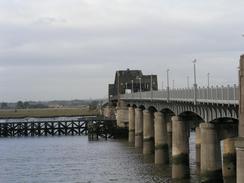
At Kincardine I was sorely tempted to extend the walk by waking on to Stirling and crossing the Firth of Forth there. I decided against this, however; I have already extended the walk to such an extent that I have walked over seven hundred miles more than I was expecting when I set off, and I did not have the relevant Ordnance Survey map for the Stirling area, and so I chose to cross the Kincardine Bridge. The Kincardine Bridge itself was not that impressive, and it had a certain air of decay about it. The bridge as opened in late 1936, a few months after my dad was born, and it seemed to show it's age. The letters proclaiming the bridge name on the overhead concrete beam were hard to read, the concrete looked dirty and the steelwork had been painted with that municipal grey steelwork colour that always seems to be dirty. The Kincardine bridge is a swing bridge to allow river traffic further up the river, and it looked as though it had not been opened for many a year. When I compared it to the beautiful, dramatic and massively over-engineered Forth Rail bridge or the graceful and elegant span of the Forth Road Bridge, it was very much an ugly duckling. As I crossed the Kincardine Bridge the fumes from the traffic were choking, which added to a certain feeling of desolation. I had crossed my last major river, and no physical barriers lay between myself and the end of the walk.
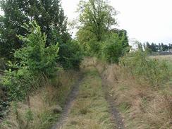
I was very relieved when, on the southern side of the Forth, I reached a place where the map shows a path leading off the A876(T). This allowed me to get away from the traffic and the fumes, and meant that for the first time in the day I did not have tarmac under my feet. Unfortunately although there is a path marked on the map the one on the ground soon petered out, but it was easy to follow field boundaries south. At one stage I passed through a field of immature bulls that started to take an interest in me, and although this was good-natured rather than threatening I do not like having twenty bulls around me, so I hopped over a barbed wire fence and into the adjacent field. Eventually, using paths and roads, I reached the northern bank of the River Carron, and I had to walk westwards for a mile along a track beside the river to get to the nearest bridge, which carries the A905 over the river (there is a large pipe bridge just before the road bridge, but this was barricaded off to prevent people from climbing over it).
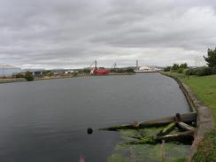
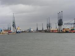
Once on the southern bank I could walk through Glensburgh and gain access to the roads through Grangemouth Docks. Initially the westernmost area of the docks looked rather neglected, with no ships of any notable size and the dockside overgrown. There was a swing bridge over part of the Western Channel that was slowly decaying, and a small boat that had half-sunk into the waters. Nearer the sea, however, and particularly in the distance by the Eastern Channel, the docks were a hive of activity, and I could see large dock cranes working and containers stacked up like Lego block on the quayside. After the decay of the Western Channel it was nice to see activity, and I watched the curious four-legged machines that pick up and move containers scurrying about. When I have been in large dock complexes previously on the walk I have been very keen to hurry out, but today, with the end so near, I could not resist walking around the public roads through the docks to observe the activity. To the south of the docks there is the large BP Grangemouth oil refinery, and this was a very different area. Whilst it was not exactly unkempt, the refinery had an unfriendly feeling to it as I walked past seemingly endless barbed wire fences, and the smell of oil unsurprisingly hung in the air.
I was glad when I finally left the Grangemouth oil refinery behind me and I could clear my nostrils of the fumes. Most of the rest of the walk was along a busy main road, and although there was a pavement to save me from walking with the traffic it was not a nice walk. To my right the Bo'ness and Kinneil Railway (a preserved line) ran on a high embankment, and I was surprised to see a new Virgin Voyager train running to and fro along it - I can only assume that the railway have hired out their line to allow testing of the new trains. I was glad when I saw a footpath sign marking a Bo'ness foreshore walk, which I naturally assumed would lead along the foreshore into the town. This it did, and it saved me from walking along more roads, for which I was thankful. In places on this path I got good views across the Forth, and it felt strange to think that I was ending the day almost directly opposite where I had started it in Culross.
By the time that I reached Mervan, which was parked near the railway line towards the railway station, I was feeling fine and was exceedingly tempted to walk further. There was little point to this, however, as I have only twenty-five miles left to walk and three days left to walk them in before the walk ends on Saturday afternoon. I have already planned to take tomorrow off so that we can visit the Falkirk wheel, a new, massive boat lift at the junction of the Union and Forth-Clyde Canals in Falkirk, and so that will lose a day, but even with this there was little point in walking further. Over the last week (yesterday excepting) I have had to put the brake on my walking somewhat to ensure that I do not finish the walk too early, although in a quite perverse way I am finding it mentally harder to do fourteen or sixteen miles a day than twenty, particularly if the weather and the terrain are good! On the other hand doing shorter days may be a good thing, as it could act as a sort of cool-down period from the obvious exertions of the trip.
Directions
This walk starts off at a car park on the western side of the village of Culross. Leave the car park and turn to the left to follow the road as it heads westwards to the north of the Firth of Forth and the railway line. The road passes a large power station, and when a road leads off to the left follow this westwards past Inch House until it ends at a T-junction with the A876(T) road. Turn left and walk along the A876(T) road as it crosses over the Kincardine bridge over the Forth, and on the other side walk on until a road comes in from the right, A few yards beyond here a path leads off to the left, heading south.
Initially the path is well marked, but it soon deteriorates before joining a track. Continue straight on southwards, and when the track ends continue on along a path that heads past Powfoulis Manor Hotel and reaching a track. Turn right along this track for a couple of hundred yards until it ends at a bend in the road, and then turn left to head southwards along this road past Stonehouse Farm and Orchardhead. When the road curves to the right continue straight on down a path that skirts through some woodland near a little lake and eventually ends at a track by the northern bank of the River Carron.
Turn right and follow the track as it heads westwards, joining a road shortly before it ends at the A905 road. Turn left and cross the river using the A905 road bridge, and once on the other side turn left to walk along the bank on the southern side of the river. Near a pipe bridge over the river turn right to join a local road, and follow this and several others through Glensburgh until it ends at a roundabout with a main road. At the roundabout turn left and follow a road that heads towards Grangemouth docks, running along the southern side of the Western Channel before curving to the right to cross over a railway siding.
On the other side of the railway line turn left along a road that heads northeastwards before looping around past the northwestern side of Grangemouth oil refinery and a culvert. At a road bridge over the culvert turn left and follow a road in a rough southerly direction past the refinery until it ends at a roundabout with the A904. Turn left and follow the road southeastwards, crossing another roundabout and the River Avon before ending at a roundabout with the A905.
At the roundabout turn left and follow the road eastwards past East Kerse Mains. Immediately after the road crosses over a railway line turn left along another main road; and after a few yards turn left along a footpath signposted as the Bo'ness shore walk. This path crosses over the railway line and continues on between the shore and the line into Bo'ness; the walk ends at a car park on the other side of the line just to the west of Bo'ness station.
Distances
| From | To | Distance (m) | Ascent (ft) | Descent (ft) |
|---|---|---|---|---|
| Culross | Kincardine | 3.8 | 177 | 167 |
| Kincardine | Grangemouth | 6.8 | 33 | 36 |
| Grangemouth | Bo'ness | 6.2 | 148 | 148 |
This makes a total distance of 16.8 miles, with 358 feet of ascent and 351 feet of descent.
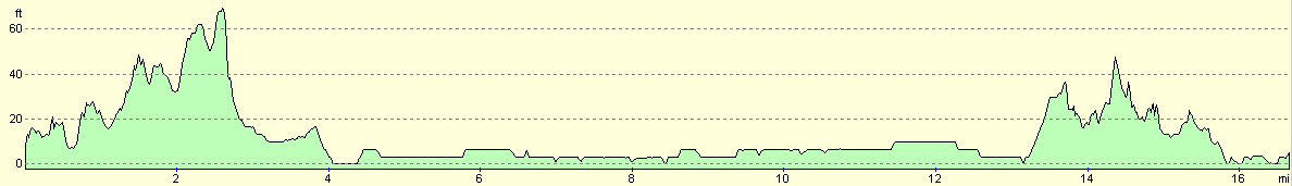
For more information on profiles, ascents and descents, see this page
Accommodation
We spent the night at the Beecraigs Country Park Caravan and Camping Site, The Park Centre, Whitebaulks, Linlithgow, West Lothian EH49 6PL, telephone (01506) 844516 or email mail@beecraigs.com, and they have a website at www.beecraigs.com. This site cost us thirteen pounds and forty pence for the night, and the facilities were first rate, with very clean and warm showers and toilets.
Disclaimer
Please note that I take no responsibility for anything that may happen when following these directions. If you intend to follow this route, then please use the relevant maps and check the route out before you go out. As always when walking, use common sense and you should be fine.
If you find any information on any of these routes that is inaccurate, or you wish to add anything, then please email me.
All images on this site are © of the author. Any reproduction, retransmissions, or republication of all or part of any document found on this site is expressly prohibited, unless the author has explicitly granted its prior written consent to so reproduce, retransmit, or republish the material. All other rights reserved.
Although this site includes links providing convenient direct access to other Internet sites, I do not endorse, approve, certify or make warranties or representations as to the accuracy of the information on these sites.
And finally, enjoy your walking!
This walk was mentioned in the following routes:
| My walk around the coastline of Britain |
Nearby walks
| # | Title | Walk length (miles) |
|---|---|---|
| 116 | Dunfermline to Dollar | 12.9 |
| 564 | Aberdour to Culross | 22.0 |
| 566 | Boness to Muirhouse | 18.9 |
|
|

|