Walk #116: Dunfermline to Dollar
 |
 |
|
General Data
| Date Walked | 21/09/2000 |
| County | Fife, Central Scotland |
| Start Location | Dunfermline |
| End Location | Dollar |
| Start time | 08.47 |
| End time | 14.45 |
| Distance | 12.9 miles |
| Description | This was quite a quite nice road walk northwest from Dunfermline. For most of the walk the Ochil Hills grow larger as you approach them. |
| Pack | Today I carried full Pennine Way kit. |
| Condition | I am still feeling okay after this walk. My feet ached a little at the end of the walk, but nothing too major or annoying. As usual after a week of walking things are becoming easier as I become fitter and more used to carrying my pack. I got another blister on my little toe on my right foot, my first new blister for a few days. I blame this on the fact that I only wore one pair of socks today as I did not bother to wear my normal outer pair. |
| Weather | Today was generally very nice and very similar (indeed, almost identical) to yesterday's weather. There was a mostly sunny sky which slowly clouded over as the day progressed. The wind was slightly less fierce than yesterday's, which was a welcome relief as the walk today was slightly more exposed. Shortly after I got to Dollar it started to spit with rain, and this evening it has been more or less constantly pouring down. |
| OS map | Landranger number 65 (Falkirk & Linlithgow, Dunfermline) and Landranger number 58 (Perth to Alloa, Auchterarder) |
Map of the walk
Maps courtesy of Google Maps. Route for indicative purposes only, and may have been plotted after the walk. Please let me have comments on what you think of this new format. For a detailed table of timings for this walk, please see the table file.
Notes
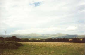
This was a fairly short and boring walk northeast from Dunfermline along some quiet roads. This was unfortunately needed so that I can reach Crieff in two day's time. The highlight of the day was seeing the Ochil Hills for the first time (which I shall have to walk over tomorrow), slowly grow larger as I approached them. They look like quite an impressive range of hills, and I am looking forwards to getting to know them better, especially if the rain that has been falling this evening finally stops.
Because my B&B did not open until 17.00 I spent just under two hours in a pub in Saline to waste some time and read my paper. Someone had fired a missile (from the looks of it, it could be a ground-to-ground rather than ground-to-air or air-to-air missile) at the MI6 headquarters in the centre of London. I hope they get the ba***rds who did it, but I bet that there are *lots* of security meetings going on at various establishments in London. Fortunately nobody was injured in the attack, and the only real harm will have been the embarrassment caused to MI6. I think that there may be a few agents from MI6 put on this case, unofficially at least.
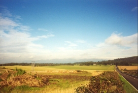
Today was yet another of road walking, which is far from the most enjoyable sort of walking but can be rewarding in itself. There are obvious dangers, however; at one stage a car (down a straight section of road) came very near to hitting me as it was speeding along, and I had to step well onto the verge to avoid it. This slightly shook me up, and reminded me that whilst walking along roads might well be quicker, it is not necessarily safer than going over hills. I wish that certain sorts of car drivers realised that walkers have just as much right to be on roads (except motorways) as they do, and gave us due respect. On the other hand, I have also nearly been hit by cyclists in the past when walking along narrow paths in the hills.
Dollar is quite a nice little village, and is dominated by Castle Campbell that rises prominently on a ridge to the north of the village and is surrounded by two burns, the Burn of Sorrow to the west and the Burn of Care to the east. The main tower house was built in about 1466 and belonged to the Stewarts of Lorne and was known as castle Gloom. Marriage caused it and the surrounding land to be passed on to the Campbells. It has seen much history in the last five hundred years, and has been attacked many times. After Cromwell and the English army defeated the Scots at the Battle of Dunbar in 1651 the castle was garrisoned with English soldiers. Four years later the castle was burnt .when the garrison was being attacked.
The castle was never fully restored, although in the 1870's some archaeological and restoration work occurred to prevent further deterioration. In 1948 the castle was offered to the National Trust of Scotland. Queen Mary spent three days in the castle in January 1563 attending the wedding of Lord Doune (James Stewart) to the 5 earl's or Argyll's sister, Margaret. Unfortunately due to my itinerary I did not get the opportunity to visit the castle, but one day I will go back to do some more walking in the Ochill Hills and to visit the castle.
The rest of the walk was fairly boring, and on the long walk to Dollar I had a really surrealistic moment when I thought that an old friend was walking alongside me for a long period. I started to cry, not with sadness but with a sort of warmness and fondness. It could have had something to do with the couple of drinks that I had had during lunch in Saline, but it was nice and quite melancholic nonetheless.
Directions
Leave Dunfermline Town Station and turn left down the road. Cross the busy main road (St Margarets Drive) by a footbridge. This emerges onto a small unkempt piece of road beside New Road. Turn right and head uphill along New Road.
As you go up the hill take the third road to the left, Canmore Street. Continue as this road crosses St Margarets Street. At a T-junction turn right and head up Bruce Street, crossing Glen Bridge Road on the way.
Continue along and turn left down Mill Street. This soon joins a main road and becomes Baldridgeburn Road. Continue westwards along this road as it joins the A907 Rumblingwell Road.
Process south-northwestwards along the A907 for a couple of miles until you come to Gowkhall. Take the third road on the right, the B913. Follow this road as it curves around and heads in a northwesterly direction past Carnock Moor and through the hamlet of Cowstrandburn. Continue northwestwards and head uphill before the road turns to the north and descends into the village of Saline.
Turn left and head down the B913 Main Street into the village. Continue along the B913 as it becomes West Road and passes an inn on the right. It then heads in a roughly westwards direction out of Saline before curving northwestwards just past Aiky Hill. The B913 continues on through West Saline, crossing the Black Devon river (the border between Fife and Clackmannanshire) and then rises up to pass to the left of a mine and to the right of Knowehead.
The road then curves sharply to the right to head in a northeasterly direction for a short period. It then curves around to the left (north) again and meets up with the A977(T) road.
Turn right down the A977(T) and then almost immediately turn left to join the B913 Devon Road as it heads northwestwards. Pass the junction with the B9140 to the left and enter an area of woodland. The road slowly curves around to head in a south-northwesterly direction as it descends a hill. It exits the woodland at the bottom of the hill, which coincides with a sharp right-hand bend in the road, after which it crosses a bridge over the River Devon and heads northwards.
Continue northwards along the B913 and cross over an old railway line in Lower Mains. The road then continues for a short distance to end in a T-junction with Bridge Street (the A91) in Dollar.
Turn right down Bridge Street and head along it past a couple of pubs until you cross a stream. Take the first road (West Burnside) to the left after the stream. This road leads steeply uphill but has nice views of the very attractive stream. At the top of the road turn right along Back Road and then continue straight on down Hillfoot's Road, where my B&B was to be found.
Distances
| From | To | Distance (m) | Ascent (ft) | Descent (ft) |
|---|---|---|---|---|
| Dunfermline | Saline | 6.4 | 558 | 377 |
| Saline | Dollar | 6.5 | 318 | 531 |
This makes a total distance of 12.9 miles, with 876 feet of ascent and 908 feet of descent.
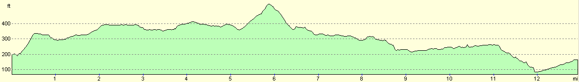
For more information on profiles, ascents and descents, see this page
Accommodation
I spent the night in a B&B in Dollar, the Tigh Ur at 4 Hillfoots Road, Dollar, FK14 7BB. The telephone number is 0374 182799, and the cost was twenty-two pounds for the night.
Disclaimer
Please note that I take no responsibility for anything that may happen when following these directions. If you intend to follow this route, then please use the relevant maps and check the route out before you go out. As always when walking, use common sense and you should be fine.
If you find any information on any of these routes that is inaccurate, or you wish to add anything, then please email me.
All images on this site are © of the author. Any reproduction, retransmissions, or republication of all or part of any document found on this site is expressly prohibited, unless the author has explicitly granted its prior written consent to so reproduce, retransmit, or republish the material. All other rights reserved.
Although this site includes links providing convenient direct access to other Internet sites, I do not endorse, approve, certify or make warranties or representations as to the accuracy of the information on these sites.
And finally, enjoy your walking!
This walk was mentioned in the following routes:
| My sectional Land's End to John O'Groats walk |
Nearby walks
| # | Title | Walk length (miles) |
|---|---|---|
| 115 | Edinburgh to Dunfermline | 17.4 |
| 117 | Dollar to Auchterarder | 12.0 |
| 564 | Aberdour to Culross | 22.0 |
|
|

|