Walk #117: Dollar to Auchterarder
 |
 |
|
General Data
| Date Walked | 22/09/2000 |
| County | Central Scotland, Tayside |
| Start Location | Dollar |
| End Location | Auchterarder |
| Start time | 09.20 |
| End time | 15.25 |
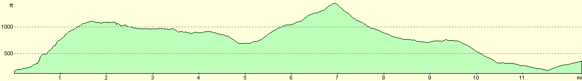
| Distance | 12.0 miles |
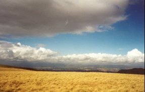
| Description | This was a lovely walk traversing the Ochil Hills on ground that was very wet underfoot. There were some marvellous views over the hills, and Castle Campbell was passed at the start of the walk. |
| Pack | Today I carried full Pennine Way kit. |
| Condition | I feel okay after this walk. I found the initial climb out of Dollar a hard slog, but I managed it with no problems and was soon striding along the top past Glenquey Resevoir. The second climb of the day out of Glendevon seemed far less of a problem and I took my time over it. The last mile along the roads into Auchterarder a slight struggle, but no real problem. I am still having trouble with the middle toe on my left foot despite the Compeed plaster that is on it. |
| Weather | Considering that it had been pouring down with rain all night, I was on the whole lucky that it stopped at about 09.00, leaving me with a day that slowly became sunnier. There was one short shower as I was climbing the small hill into Auchterarder, but apart from that everything was fine, with a small amount of wind, although as normal this wind was far more fierce higher up in the hills. |
| OS map | Landranger number 58 (Perth to Alloa, Auchterarder) |
 |
 |
|
Map of the walk
Maps courtesy of Google Maps. Route for indicative purposes only, and may have been plotted after the walk. Please let me have comments on what you think of this new format. For a detailed table of timings for this walk, please see the table file.
 |
Notes
As usual I found a day consisting of a hill range traverse (in this case the Ochil range) to be a massively enjoyable experience. There had been over twelve hours of near continuous rain the night before, but fortunately this ended about twenty minutes before I set off (although I had delayed my departure to ensure a dry start to the walk).
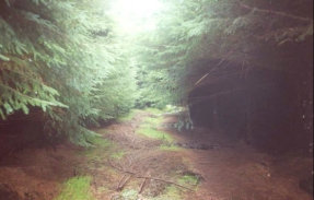
The first climb from Castle Campbell to Maiden's Well and on past Glenquey Reservoir was very wet underfoot, and indeed in places the path was more like a stream with water pouring down it. The path through the forest was especially muddy, with the path churned up, allowing my feet to sink up to the ankles in the mud. The forestry owners had tried to make the path passable by laying down small branches from the conifers in the mud which helped, but where these had not been laid the going was tough.
Between the forest and Glenquey Reservoir there as a burn coming down from the hillside to the left that was in flood. I spent a few minutes studying the burn and testing the depth with my walking poles before carefully crossing the burn safely, with only a tiny amount of moisture getting into my left boot.
At Glenquey Reservoir I met three lads who were doing their Duke of Edinburgh's silver award. After warning them about the burn ahead of them, I chatted to them for a short period about walking. It was their first day out, and it was not a very nice morning to be starting a trip in the hills. I felt quite old as I chatted to them, as if I was an old wizened man of the hills who was imparting knowledge to the young whippersnappers whom he had met. Perhaps I am getting old...
I stopped in Glendevon to visit the pub / hotel there for half an hour. Whilst I was there a cyclist came in who had just come from Auchterarder - and indeed apparently had been staying in the same B&B that I will be staying in tonight - (and it turns out that it was even the same room!). This is what I really like about walking - meeting people and getting the chance to have conversations with them. You just don't get the same opportunities if you drive, or even cycle.
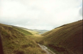
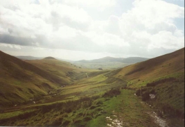
The second half of the walk from Glendevon to Auchterarder was very nice, with some lovely views being available, especially from the 474-metre summit that I climbed up to from the col separating two hills. I was considering walking from this summit to another summit called Steele's Knoll about a mile away which had a Trig point on it, but I decided against it. This is what hill walking is all about in my opinion - lovely views, great hills, bubbling streams in the valley below and a good, firm track to walk upon. The descent down to the farm was very nice, although near the bottom of the hill at Coulshill Farm the track become slightly more uneven and rocky.
I injured my hand slightly on a gate at the farm at Coulshill - the catch was on the other, downhill side of the gate, and as I put my hand over to throw that catch and open the gate my hand impaled itself on a couple of barbs on barbed wire that had been wrapped around the post near the catch. This was very annoying indeed and hurt for a good few hours afterwards.
The long three-odd mile walk from Coulshill into Auchterarder was a quite boring walk along roads which I just wanted to get over with - I felt that it was a shame to end a lovely hill walk with such a boring road walk, especially when at the end I was approaching the noisy A9(T) which was crossed by a bridge. The worst thing was that when I had been studying the map the night before I had ignored the road part of the walk and had concentrated on the hill section, so the length of the road walk came as a slight surprise.
I am totally ecstatic tonight as I have completed the walk sections that I had intended to do this trip. Tomorrow I shall walk up to Crieff, which is a very good place to leave the walk for next year. Yet again I have beaten the weakness of my body (particularly my left ankle) and have completed a multi-day hiking trip. I can only hope that I can continue to perform as well next year, when the hills become bigger and more treacherous.
Directions
From the centre of Dollar head up the hill to the north, beside the stream. At the junction turn right and follow the signs to Castle Campbell along a road that heads quite steeply uphill past Gloom Hill.
Pass to the left of a car park. At a house the road turns sharply to the left and descends down to the castle. Do not follow the road round but take a footpath that leads straight on uphill. This soon enters a forested area and continues to rise. This area was very boggy when I passed through it, and someone (probably estate workers) had put branches from the conifers on the ground in the worst bits which made it easier to pass.
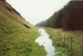
The path leaves the forest and then skirts the edge of the forest as it heads northwards in the valley between Castleton Hill to the east and Whitewisp Hill to the left. The forest ends at NN 971 014 and the path continues on gently up the valley. It soon reaches a summit, and then starts a descent down to Glenquey Reservoir beside a stream. Minor streams coming in from the left had to be crossed in a couple of places, and one of these was quite deep and wide after the heavy rain of the previous night.
The path meets a track at the southern end of Glenquey reservoir. Follow this track as it heads northwards beside the western bank of the reservoir. Pass the Reservoir's dam and leave the track as it curves to the right to a farm. A path passes to the left of the farm through some gates.
The path then descends on the left bank of the valley above the stream. When the path starts to turn to the left take a minor grassy track that winds down to some houses at Burnfoot. Join the minor road and follow it eastwards. Almost immediately turn left and descend down a footpath across a floodplain to a footbridge over the River Devon.
The bridge brings you out on the road in Glendevon. To the right is an Inn at which refreshments can be purchased. Turn left along the A823 until you reach the entrance to the Glendevon Youth Hostel on the right. Take a track leading to the right of the youth hostel. This track leads up to a little house at Glenfoot. Pass to the right of the house and then take a path that leads up to the north, following the western bank of Borland Glen.
The path slowly gains height, and joining a green track for a period as it reaches the top of the valley between Green Law to the east and an unnamed summit to the west. The path then descends along an obvious course to meet the eastern bank of the little Coul Burn. Follow the path down as it crosses to the western bank of the Burn and descends to meet a minor road at Coulshill.
Follow this road as it ascends up through an area of forest to Upper Cloan, and then descends to Cloan. Continue along the road as it heads in a northwesterly direction through Thorn. When the road ends at a T-junction turn right. This new road almost immediately turns sharply to the left to heads northwest under a railway line. The road then turns sharply to the right to parallel the A9(T) dual carriageway for a short distance before a road to the left crosses the A9(T) via a bridge. Cross this bridge into Milton and follow the road as it starts the climb uphill. When the road ends at a T-junction turn left and walk along the A824 uphill for a short distance into Auchterarder.
Distances
| From | To | Distance (m) | Ascent (ft) | Descent (ft) |
|---|---|---|---|---|
| Dollar | Glendevon | 4.8 | 1152 | 620 |
| Glendevon | Auchterarder | 7.2 | 1083 | 1421 |
This makes a total distance of 12.0 miles, with 2235 feet of ascent and 2041 feet of descent.
For more information on profiles, ascents and descents, see this page
Accommodation
I spent the night at Allendale House, 17 High Street, Auchterarder. (Tel. 01764 663329). This was a very nice B&B, with a very friendly landlady who made me feel very much at home.
Disclaimer
Please note that I take no responsibility for anything that may happen when following these directions. If you intend to follow this route, then please use the relevant maps and check the route out before you go out. As always when walking, use common sense and you should be fine.
If you find any information on any of these routes that is inaccurate, or you wish to add anything, then please email me.
All images on this site are © of the author. Any reproduction, retransmissions, or republication of all or part of any document found on this site is expressly prohibited, unless the author has explicitly granted its prior written consent to so reproduce, retransmit, or republish the material. All other rights reserved.
Although this site includes links providing convenient direct access to other Internet sites, I do not endorse, approve, certify or make warranties or representations as to the accuracy of the information on these sites.
And finally, enjoy your walking!
This walk was mentioned in the following routes:
| My sectional Land's End to John O'Groats walk |
Nearby walks
| # | Title | Walk length (miles) |
|---|---|---|
| 116 | Dunfermline to Dollar | 12.9 |
|
|

|