Walk #115: Edinburgh to Dunfermline
 |
 |
|
General Data
| Date Walked | 20/09/2000 |
| County | Lothian, Fife |
| Start Location | Edinburgh |
| End Location | Dunfermline |
| Start time | 08.20 |
| End time | 15.30 |
| Distance | 17.4 miles |
| Description | This was a long road walk that included a fairly spectacular walk over the Forth Road Bridge, with the frankly amazing Forth Rail Bridge standing alongside it. |
| Pack | I carried no pack on this walk. |
| Condition | I feel okay after todays walk. I left my pack in Edinburgh today and walked without it, which of course meant that I was not under too much strain. My feet ache slightly, but apart from that I feel fine. |
| Weather | The weather today was generally fine for walking. The sky started off sunny and reasonably warm as I was leaving Edinburgh, but with quite a fierce south-westerly wind that was very noticeable on exposed parts of the walk. Later on the sky clouded over and the sun mostly disappeared, and whilst I was in Dunfermline it started to lightly spit with rain, but not enough to cause me any worry. |
| OS map | Landranger number 66 (Edinburgh, Penicuik & North Berwick) and Landranger number 65 (Falkirk & Linlithgow, Dunfermline) |
Map of the walk
Maps courtesy of Google Maps. Route for indicative purposes only, and may have been plotted after the walk. Please let me have comments on what you think of this new format. For a detailed table of timings for this walk, please see the table file.
Notes
A day of full road walking saw me get to Dunfermline, the ancient capital of Scotland. I left my pack at the Backpacker's Hostel in Edinburgh and walked along without it, which helped relieve the strain on my body for the day. When I got to Dunfermline I went to the Tourist Information office in the city to get some accommodation details before walking back to the station.
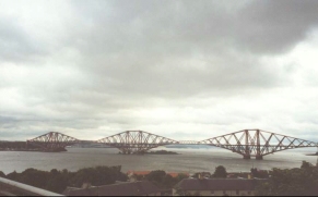
The highlights of the day were threefold - firstly, catching a glimpse of the Forth rail bridge, and beyond it the Road bridge through a gap in the trees on the descent down to South Queensferry. Although I have seen pictures of these bridges before, to see them in reality was something else. Civil engineering is a subject that I have been interested in for some time, and it was interesting to compare the differences between the two structures - the sheer extravagance of the over-engineered rail bridge, and the sleek, slender lines of the road bridge.
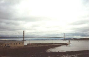
The second highlight was the walk along the Forth road bridge. This is something that really has to be experienced, as the whole roadway vibrates in a weird way as lorries pass you. The scale of the engineering of the bridge is impressive, similar to the rail bridge but on a wholly different scale. I walked slowly over the road bridge observing little details; the way the cables were attached to the decking; the way the cable saddles were constructed; and the method of coping with expansion in the decking during summer. Basically the entire walk over the bridge was stunning.
The third thing was probably the best. After I had got back to the hostel in Edinburgh I went for a pizza at the Pizza Hut that is a few doors up Cockburn street from the hostel. I was sat on a table next to one at which a nice blonde with cute freckles was sat. We started talking about the hostel and she asked me to join her, and we ended up going for a few drinks together. She is a Canadian from British Colombia, and had arrived in Edinburgh late the previous evening. I hope that we manage to keep in contact, as we got on very well. Quite why she started talking to a weirdo with an unkempt beard (i.e. me) is a total mystery!
Dumfermline is quite a historic town, and is the ancient capital of Scotland. The western nave of the Abbey was built by David 1 (son of Malcolm Canmore and St Margaret. Robert the Bruce is buried in the Abbey, as the town was the burial site of the Scottish monarchs before the Island of Iona was adopted for the purpose.
Unfortunately I found the outskirts of the town to be quite drab, with a couple of burnt-out cars being dumped near the railway station. A square mile of the town centre is an area of historic conservation and hence fairly well kept, but outside this area it was a bit of a mess. This was a great shame, as it has so much going for it.
Directions
From the Hostel on Cockburn Street I turned right down the road and then almost immediately right again, to descend some steps that bring you out on Market Street beside Wavereley Station. Go through Waverley Station on the overhead footbridge and follow it out onto Princes Street.
Turn left down Princes Street and follow it westwards to the junctions with Lothian Road, Shandwick Place and Queensferry Street (the A90). Turn half-right up the latter and follow it past Randolph Crescent and over a bridge over the quite spectacular Water of Leith far below.
Shortly after the bridge Queensferry Road curves to the left and starts to head due westwards. Cross a roundabout with Queensferry Terrace to the left and continue ahead. Pass the junction with Cragleith Road and continue on to the junction with Telford Road (the A902).
The A90 then continues on past Davidson's Mains and then uphill with some woodland to the left. It then descends to another roundabout, this time it is the junction with Maybury Road (the A902 again).
Queensferry road continues on and then turns half-right and passes over Crammond Bridge. On the far side of the bridge a cycleway heads off to the right, avoiding the dual carriageway. This cycleway uses a local road initially as it heads uphill to a bridge over the A90 to the left, and then becomes a paved track beside, but slightly separated from, the dual carriageway.
The A90 and cycleway soon reaches a junction with the B924 to the right. The cycleway leaves the course of the A90 and joins the B924. This heads northwestwards to the west of some parkland and then descends, becoming Hawe Brae Road. Near the bottom of the hill it passes under some of the southern approach arches of the Forth Railway Bridge, and some good glimpses of both the road and rail bridge can be obtained on the descent down the hill into South Queensferry.
After the bridge the road curves to the left to parallel the sea and becomes New Halls Road. This continues past South Queensferry lifeboat station and becomes High Street. Continue along here past the junction with The Loan road. When the road turns to the left to head uphill head straight on along Shore Road, which passes under the approach viaduct for the Forth Road Bridge.
Some steps lead up to the left from under the bridge and take you out onto the top of the suspension bridge by the tollbooths. Immediately under the bridge you get a choice as to whether to walk across the bridge on the western or eastern side; I chose the eastern side as it gives you great views of the Forth Railway Bridge as you cross.
Cross the road bridge, feeling it sway under you when large lorries pass. At the northern end of the bridge a path leads off to the right and descends via some steps to a road. Turn right along this road and pass under the approach spans of the bridge.
The road bends around to the north and parallels the northern approach to the bridge. It then comes out at a roundabout below the bridge approach road. Turn half-right here, and head up Hope Street into Inverkeithing. This then becomes High Street and Church Street as it passes through the centre of the town and Chapel Place by the railway station.
This road ends at a T-junction with Admiralty Road. Turn right along this road and cross over the railway, and then turn left along North Road (the B981). Take the first left along Masterton Road and use it to cross over the M90. After the motorway this road curves around and meets the B916 at a roundabout. Turn left at the roundabout and head down Aberdour Road.
Continue westwards down the road until you reach Blacklaw Road on the right. Take this road and descend to the bottom of the hill and a stream before ascending to a T-junction with Woodmill Road. Turn left down this road and follow it until it becomes Woodmill Street. Dunfermline Town railway station is to the right.
Distances
| From | To | Distance (m) | Ascent (ft) | Descent (ft) |
|---|---|---|---|---|
| Edinburgh | Crammond Bridge | 5.5 | 358 | 492 |
| Crammond Bridge | Forth bridge (south end) | 4.1 | 413 | 387 |
| Forth bridge (south end) | Dunfermline | 7.8 | 725 | 604 |
This makes a total distance of 17.4 miles, with 1496 feet of ascent and 1483 feet of descent.
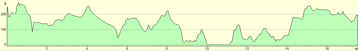
For more information on profiles, ascents and descents, see this page
Accommodation
I spent the night in the Backpacker's Hostel, in Cockburn street in Edinburgh, which is between the station and the Royal Mile. This is a very nice hostel (if you like that sort of thing, which I do), and cost £11.50 a night.
Disclaimer
Please note that I take no responsibility for anything that may happen when following these directions. If you intend to follow this route, then please use the relevant maps and check the route out before you go out. As always when walking, use common sense and you should be fine.
If you find any information on any of these routes that is inaccurate, or you wish to add anything, then please email me.
All images on this site are © of the author. Any reproduction, retransmissions, or republication of all or part of any document found on this site is expressly prohibited, unless the author has explicitly granted its prior written consent to so reproduce, retransmit, or republish the material. All other rights reserved.
Although this site includes links providing convenient direct access to other Internet sites, I do not endorse, approve, certify or make warranties or representations as to the accuracy of the information on these sites.
And finally, enjoy your walking!
This walk was mentioned in the following routes:
| My sectional Land's End to John O'Groats walk |
Nearby walks
| # | Title | Walk length (miles) |
|---|---|---|
| 114 | Tranent to Edinburgh | 10.6 |
| 116 | Dunfermline to Dollar | 12.9 |
| 222 | Edinburgh Castle to Seton Sands | 14.0 |
|
|

|