Walk #566: Boness to Muirhouse
 |
 |
|
General Data
| Date Walked | 26/09/2003 |
| County | Central Scotland, Lothian |
| Start Location | Boness |
| End Location | Muirhouse |
| Start time | 08.22 |
| End time | 15.39 |
| Distance | 18.9 miles |
| Description | This was a surprisingly nice walk, with not much road walking to be done as I made my way east along he southern side of the Firth of Forth. |
| Pack | Today I carried my 30-litre Karrimor HotRock rucksack, which was filled with my packed lunch, waterproof leggings, water bottle and a couple of spare shirts, together with the usual assortment of odds and ends. |
| Condition | I feel absolutely fine after this walk, and I could easily have walked further if I had needed to. |
| Weather | Today was a nice, sunny day, with not much wind to annoy me. It was quite cold to start with, but it soon warmed up enough for me to take my fleece off and enjoy the sunshine. |
| OS map | Landranger number 65 (Falkirk & Linlithgow, Dunfermline) and Landranger number 66 (Edinburgh, Penicuik & North Berwick) |
 |
 |
|
 |
 |
|
Map of the walk
Maps courtesy of Google Maps. Route for indicative purposes only, and may have been plotted after the walk. Please let me have comments on what you think of this new format. For a detailed table of timings for this walk, please see the table file.
 |
Notes
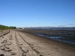
When I woke up this morning I found that my legs were slightly leaden, which was very probably a result of having taken a day off yesterday. This did not put me in the most confident of moods, although I found that as soon as I stepped out of Mervan my mood lightened and I cheered up considerably. Bo'ness is the headquarters of the Bo'ness and Kinneil Railway, and I had a quick look at the area around the station. Although the museum was shut, I could still see a very nice example of a steam crane, and also a very small wagon turntable. Leaving the station I then skirted around the seaward side of the museum and found a path that followed the foreshore eastwards. This walk was quite pleasant at times, although it was quite industrial in other places. Eventually I reached a brand-new cycle path that took me through some woodland, although once this ended just before the end of the woodland I had to divert onto the foreshore and walk along this. This was hardly a problem as the tide was out, and I quite enjoyed the walk along the initial stretch.
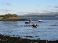
Unfortunately after the initial stretch it became slightly harder going underfoot as the foreshore consisted of shingle sloping down to a mud with only scatter patches of sand. I was therefore quite relieved when I reached the little village of Blackness, notable for its castle that I walked on the landward side of. I soon reached the foreshore again, and instead of walking along a track marked on the map as running through Wester Shore Wood, I walked along the foreshore once again. When I reached the mouth of the Midhope Burn I strode across it as it was shallow, getting my left foot slightly wet in the process, and continued on along the foreshore. Eventually when a public road began near the quaintly named Society House I joined it, and walked on eastwards towards South Queensferry. From the road I did not manage to get any decent views of the Forth road bridge, which was a shame, and I soon headed down into the village, which was far prettier than I remembered if being on a previous trip. I went into the Ferry Tap Inn in South Queensferry for a quick pint of Orkney Ale, before heading off once again through the village.
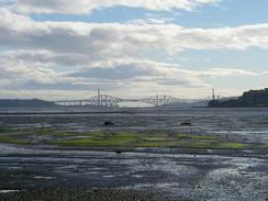
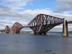
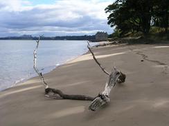
On my previous walk from Edinburgh to Dunfermline I had walked along the A90 to the Forth road bridge, but this time I was determined to walk through the grounds of Dalmeny House, which promised to be a far more coastal and attractive route. A good track lead eastwards from the B924 road under the magnificent Forth rail bridge to Long Craig Gate, where I noticed a sign stating that the ferry across the River Almond was not running and that you had to plan the walk accordingly. I had not intended to take the ferry, but it made me slightly uneasy nonetheless. I continued on regardless and followed tracks through the woodland past Peatdraught Bay to Hound Point, when I dropped down onto a lovely stretch of beach. This ended by Barnbougle Castle, where I had to divert inland past the massive and beautiful Dalmeny House to gain access to the beach once more, which took me down to Snab Point. The views from the beach across the Forth were lovely, and it made me sad to realise that this was probably going to be the last beach of the walk.
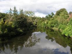
Eventually I reached Cobble Cottage, from where the ferry across the River Almond normally leaves. The River Almond at this point is quite narrow, but there was absolutely no way that I was going to even think of fording it, as it was flowing quite swiftly and it was obviously fairly deep, as boats were moored in it. Instead I worked my way back slightly, and then headed southwestwards along tracks for a little over a mile towards the A90 and the old bridge over the river. On the eastern side of the bridge a footpath took me back northeastwards towards the mouth of the river, along an exceedingly pleasant walk, which at times climbed up and down some river cliffs. It was an absorbing walk, and I enjoyed it immensely before eventually reaching the mouth of the river, where I stopped and looked across at Cobble House on the other side.
From Crammond a causeway heads for a kilometre out to Crammond Island, although as the tide was in all I could see of it was a series of concrete posts extending out from a jetty. The day after I walked past two boys got trapped by the rising tide halfway across, and had to be rescued by lifeboat - a salutary warning. I made my way eastwards towards the campsite, but I as I had expected the walk to end at Crammond Bridge I had not taken the next Ordnance Survey map that I needed to find the campsite. I phoned Sam up and she gave me the grid reference, and using my GPS it was easy to find the site, and it was with relief that I reached it and I collapsed into Mervan.
This evening Jacqui, a friend of ours and an ex-colleague of mine from Cambridge, turned up and she put the tent between Mervan and my parent's caravan, before the three of us headed out to meet some other friends who had flown up from Cambridge for the end of the walk. We all met in Leith, and it was most heart-warming to spend time with so many friends. It was a superb evening, and it took my mind off the quite depressing thought that the walk was very nearly at an end.
Directions
This walk starts off at a car park just to the west of the railway station in Bo'ness. Leave the car park and walk eastwards along the road; when it curves around to the right continue straight on for a few yards until a footbridge over the line is met before the station. Cross the footbridge and on the other side follow a path past a museum and the eastern end of a little harbour.
The path curves to head eastwards along the shore, initially through a pretty area that soon becomes quite industrialised. It squeezes between the shore and industrial units in once place, before reaching a track. Turn right down this track and then left, to head southeastwards. It soon becomes a cycle path that heads through some woodland; however before this woodland ends the path ends and I had to walk along the foreshore, which may be difficult if the tide is high.
Follow the foreshore southeastwards for about a mile past Blackness Bay to Blackness. In the village climb up onto a road and then pass the end of the main road and head southeastwards along a track, with some houses on the left. When the track ends continue straight on along a path that brings you out to the shore once again. Follow the shoe eastwards past Wester Shore Wood, crossing over Midhope Burn (I forded this, but there is a nice stone bridge a little further upstream).
Skirt the foreshore around the grounds of Hopetoun House until a road starts to the east at Society House. Join this road, and follow it eastwards past Port Edgar and into South Queensferry. The road passes under the Forth Road Bridge, and immediately on the eastern side of the bridge is a road junction. At the junction turn left down the B924 road that heads down to the shore through South Queensferry.
Head through South Queensferry along the B924 road until it passes under the Forth Rail Bridge. Here the road curves to the right uphill; continue straight on along a track that skirts the shore to Long Craig Gate. Continue on along the track as it enters some woodland to Hound point, and then descend down a little slope to gain access to the beach. Follow the beach southeastwards towards Barnbougle Castle.
The tide was high when I reached here and I could not get along the foreshore past the castle, so I diverted inland to a track that passed the front of Dalmeny House before heading back to the shore and walking along that to Snab point. At Snab Point the foreshore was impassable once again, so I climbed up to join a path that headed eastwards past Eagle Rock, joining a track for the last stretch to Cobble Cottage, where the ferry to Crammond normally runs from.
Instead of taking the ferry I walked back along the track for a short distance before turning to the left down another track that headed southwestwards to East Craigie and Crammond Bridge on the A90. Do not join the A90 but turn left down a cycle path that leads to the old bridge over the River Almond. Cross this bridge, and on the other side turn let along a footpath that heads northeastwards along the eastern shore of the River Almond. The path climbs up the cliffs at one stage before descending back to the river level and reaching the sea at Crammond. In Crammond head along a track that curves to the right and follows the shore eastwards. The path is very good, but after a couple of kilometres turn right along a path that climbs up the hill to the south and brings you up to Marine Drive. The campsite where this walk ends is a little distance to the left along Marine Drive.
Distances
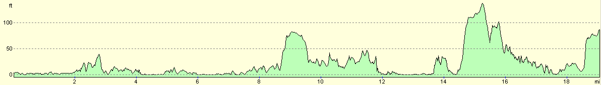
| From | To | Distance (m) | Ascent (ft) | Descent (ft) |
|---|---|---|---|---|
| Boness | South Queensferry | 9.7 | 433 | 364 |
| South Queensferry | Muirhouse | 9.2 | 784 | 768 |
This makes a total distance of 18.9 miles, with 1217 feet of ascent and 1132 feet of descent.
For more information on profiles, ascents and descents, see this page
Accommodation
We spent the night at the Edinburgh Caravan Club site, Marine Drive, Edinburgh EH5 5EN, telephone (0131) 312 6874. This site was, as usual for a caravan club site, absolutely immaculate, although it was rather expensive at eighteen pounds per night (this was mainly because our membership for the caravan club had run out, and thus we did not get a five pound reduction). Busses to the centre of Edinburgh run regularly, even on a Sunday, and the site is a stone's throw from the seafront.
Disclaimer
Please note that I take no responsibility for anything that may happen when following these directions. If you intend to follow this route, then please use the relevant maps and check the route out before you go out. As always when walking, use common sense and you should be fine.
If you find any information on any of these routes that is inaccurate, or you wish to add anything, then please email me.
All images on this site are © of the author. Any reproduction, retransmissions, or republication of all or part of any document found on this site is expressly prohibited, unless the author has explicitly granted its prior written consent to so reproduce, retransmit, or republish the material. All other rights reserved.
Although this site includes links providing convenient direct access to other Internet sites, I do not endorse, approve, certify or make warranties or representations as to the accuracy of the information on these sites.
And finally, enjoy your walking!
This walk was mentioned in the following routes:
| My walk around the coastline of Britain |
Nearby walks
| # | Title | Walk length (miles) |
|---|---|---|
| 114 | Tranent to Edinburgh | 10.6 |
| 115 | Edinburgh to Dunfermline | 17.4 |
| 116 | Dunfermline to Dollar | 12.9 |
|
|

|