Walk #560: Tayport to St Andrews
 |
 |
|
General Data
| Date Walked | 18/09/2003 |
| County | Fife |
| Start Location | Tayport |
| End Location | St Andrews |
| Start time | 08.45 |
| End time | 17.33 |
| Distance | 20.6 miles |
| Description | This was a far better walk than those of the last couple of days, with far better views and much better terrain. |
| Pack | Today I carried my 30-litre Karrimor HotRock rucksack, which was filled with my packed lunch, waterproof leggings, water bottle and a couple of spare shirts, together with the usual assortment of odds and ends. |
| Condition | I feel absolutely fine after this walk, and I could easily have walked further if the need had arisen. My feet were both okay, although I did get a couple of twinges from my neck. |
| Weather | It was a very mixed day today weather wise; there were periods of sunshine interspersed with the cloud, and although there was a breeze it was quite a warm one. Towards the end of the day, however, it started to drizzle; initially this was light, but it got heavier as the evening approached, although it was never heavy enough to force me to put my coat on. |
| OS map | Landranger number 59 (St Andrews, Kirkcaldy & Glenrothes) |
 |
 |
|
 |
 |
|
Map of the walk
Maps courtesy of Google Maps. Route for indicative purposes only, and may have been plotted after the walk. Please let me have comments on what you think of this new format. For a detailed table of timings for this walk, please see the table file.
 |
 |
|
Notes
It was still dark when I woke up this morning, and when I opened the blinds the view across the harbour and Tay to Broughty Ferry were fairly superb. Lights were reflecting in the harbour, and I watched them for a while as the sun slowly rose and the sky lightened. I was in no particular hurry to set off, as I have a relatively short distance left to walk and man days in which to do it, even if I extend the walk by walking around the Firth of Forth, and so I decided to make St Andrews my target for the day.
The initial stretch of the walk led eastwards from Tayport towards Tenstmuir Point; this initially followed a cycle path but I then walked along the foreshore, which was initially compacted mud but soon became firm sand. It was a lovely walk, and the views across the mouth of the Tay towards Buddon Ness were quite absorbing and helped while away the miles as I walked. Abut halfway to the point I chatted to a man who was out waling his dog, and when he asked me where I was walking to I told him Edinburgh, and he replied that it was not a long walk. It feels very strange being told that, as Edinburgh has seemed a massive distance away for most of this year.
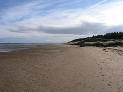
The Fife Coastal Path goes along tracks through Tentsmuir Forest, but as the tide was but I decided to follow the beach southwards towards RAF Leuchars. The sand was not the firmest that I have walked on, and this made progress annoyingly difficult in places. As the miles passed I saw two different colonies of seals, one at the northern end of the beach and one at the southern, all of whom seemed totally undisturbed by the sound of fast jets taking off and coming in to land at the airfield. I quire enjoyed watching them circle overhead, and the noise, although fierce, was not too annoying.
The path diverts inland from the car park in the forest to Leuchars along a road, but I decided to continue south along the beach. In his book, John Merrill describes the northern shore of the River Eden estuary to be thick, glutinous mud, so I decided that I would avoid it and walk between the northern fence of RAF Leuchars and Reres Wood. This worked out quite well as there was a distinct path on the ground that soon became a track, and I got good views of the jets coming in to land. Eventually I found myself in the middle of the village of Leuchars, and the church of St Athernase in the town has a tower that is of an unusual and interesting Italianate design. Sam was waiting for me in the car park of a hotel next to a roundabout on the A919, and after doing a little shopping we went in for a well-deserved drink.
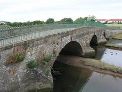
A quick walk took me south along the A919 past the paper mill at Guardbridge and down to the bridges over the River Eden. At one stage there were three bridges here, but all that remains of the Rail Bridge that closed in 1969 are the bases of the piers. The coastal path follows the A91 all the way into St Andrews, and there is a separate cycle path beside the road, but once I got to the start of one of the many golf courses to the west of the town I decided to attempt to walk up to Out Head. I walked north for a couple of hundred yards through a field on the perimeter of the first golf course, made my way over the old railway embankment and was faced with a field of flat mud in the estuary of the Eden. I was slightly nervous as I stepped down into it, but the surface proved to be quite firm in most places, the exceptions being where streams or outfalls ran into it. It should be noted that at high tide this would be impassable, as the high tide mark was well up the retaining wall of the railway embankment.
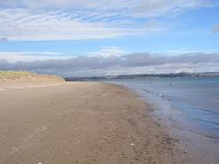
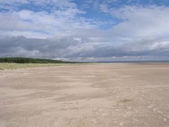
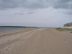
I made my way along the side of the estuary as it started to curve past the golf courses and head north towards Out Head. On the way the mud slowly became sandier, until at the point I could walk on firm sand. The point marks the mouth of the River Eden, and it looked narrow enough to wade across, but the currents looked strong and I was unsure about how deep it was, so I was glad that I had diverted around the river instead of attempting to wade. The rest of the walk into St Andrews was easy; a simple walk south for a couple of miles along firm sand. It was the busiest beach that I have seen for some time, but even then it was far from packed. Eventually I reached St Andrews and met Sam near the aquarium. She had parked Mervan at the campsite to the east of the town, and as she did not need to drive any more than day I suggested that we go for a drink. We ended up at the Tudor Inn in the town, and we had a nice chat as we supped a pint each.
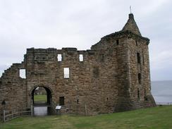
The stagger from the centre of the town to the campsite took me past the ruins of the castle and cathedral, both of which were quite spectacular, and past many of the university buildings, which were all fairly attractive. St Andrews is dominated by the university and golf, which explains all the courses that I passed to the west of the town. I have never really understood the attractions of golf, but nonetheless I can see that it is a skilful game and I daresay the members of the Royal and Ancient, which is based in the town, would finds it easy to disagree with me. I must admit that on balance I liked the town, and would not mind coming here again when I have more time for a better look around.
All of the twenty mile days that I have put in recently have meant that I am ahead of schedule, and have three or four days in hand before I reach Edinburgh. I am loathe to take that many days off, and so I may well try and use some of those days up by extending the walk along the Firth of Forth to Falkirk, which will also have the added side effect of increasing the mileage. I really do not want this trip to finish, and just the thought of the end makes me feel depressed. I wish that the trip could go on, but my body is starting to show the signs of wear, Sam has had enough and it is frankly time to get back to a different sort of reality.
For more details of the Fife Coastal Path, have a look at Bill's Fife Coastal Pathwebpages, the Official Fife Coastal Path pages, or Another good site.
Directions
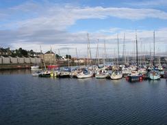
This walk starts off by the harbour in Tayport. For the first mile it follows the cycle path that passes the harbour and runs along the coast past a caravan site towards Lundin Bridge. The path is easy to follow as it is well signposted and just follows the coast. At Lundin Bridge I joined the foreshore and followed this as it headed eastwards for nearly four kilometres toward Tentsmuir Point. The foreshore is sandy and the sand was firm enough to walk along easily. At Tentsmuir Point turn to the right and started heading south along Tentsmuir Sands, with Tentsmuir Forest a short distance inland.
After five miles the moth of the River Eden is reached; before this turn right to head along a path that runs immediately between the southern edge of Reres Wood and RAF Leuchars. This path soon becomes a track that winds around the northern fence of the RAF base. Near Comerton it becomes a road that can be followed westwards into Leuchars. At the church in the village turn left and then when the road almost immediately ends turn right along another road that leads westwards to a roundabout on the A919 road. At the roundabout turn left to walk south along the A919 road for a couple of miles; on the way it passes Leuchars railway station and crosses over Motray Water.
At a roundabout with the A91 turn left to walk east along the A91; there is a handy off-road cycle path that makes the journey far safer. After a couple of miles a golf course is reached on the left; just before the golf course turn left and walk through a field and over the railway embankment to gain access to the foreshore of the River Eden (Note that this part of the route can only be followed at low tide). Turn right and follow the shoreline as it slowly curves around to head northwards to Out Head. The foreshore starts off being firm mud, but eventually becomes sandy and easier going. At Out Head follow the shoreline as it curves around past the mouth of the River Eden and heads south towards St Andrews.
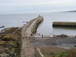
In St Andrews climb up onto the shoreline and follow the signs for the Fife Coastal Path eastwards through the town. The route passes the ruins of the castle and the cathedral before reaching the small harbour and curving past East Sands. On the eastern end of the sands the path climbs uphill; the campsite where this walk ends is on the right at the top of the slope.
Distances
| From | To | Distance (m) | Ascent (ft) | Descent (ft) |
|---|---|---|---|---|
| Tayport | Leuchars | 11.3 | 177 | 148 |
| Leuchars | Campsite near St Andrews | 9.3 | 440 | 318 |
This makes a total distance of 20.6 miles, with 617 feet of ascent and 466 feet of descent.
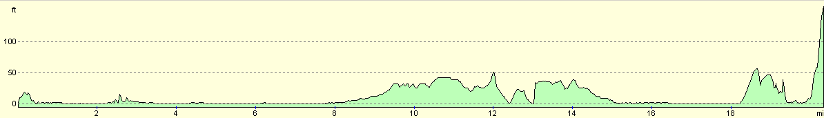
For more information on profiles, ascents and descents, see this page
Accommodation
We spent the night at the Kindell Braes Caravan Site, St Andrews, Fife KY16 8PX. This site cost us fourteen pounds for the night, and the facilities were quite reasonable. They can be contacted on (01334) 474250.
Disclaimer
Please note that I take no responsibility for anything that may happen when following these directions. If you intend to follow this route, then please use the relevant maps and check the route out before you go out. As always when walking, use common sense and you should be fine.
If you find any information on any of these routes that is inaccurate, or you wish to add anything, then please email me.
All images on this site are © of the author. Any reproduction, retransmissions, or republication of all or part of any document found on this site is expressly prohibited, unless the author has explicitly granted its prior written consent to so reproduce, retransmit, or republish the material. All other rights reserved.
Although this site includes links providing convenient direct access to other Internet sites, I do not endorse, approve, certify or make warranties or representations as to the accuracy of the information on these sites.
And finally, enjoy your walking!
This walk was mentioned in the following routes:
| My walk around the coastline of Britain |
Nearby walks
| # | Title | Walk length (miles) |
|---|---|---|
| 556 | Seaton House to Broughty Ferry | 17.6 |
| 557 | Broughty Ferry to Errol | 16.5 |
| 559 | Abernethy to Tayport | 20.9 |
|
|

|