Walk #557: Broughty Ferry to Errol
 |
 |
|
General Data
| Date Walked | 15/09/2003 |
| County | Tayside |
| Start Location | Broughty Ferry |
| End Location | Errol |
| Start time | 08.02 |
| End time | 15.48 |
| Distance | 16.5 miles |
| Description | This was quite a frustrating day's walk, with far to much road walking and a long delay that made me feel as though I was making no progress. I did get to have a nice look around Dundee, however. |
| Pack | Today I carried my 30-litre Karrimor HotRock rucksack, which was filled with my packed lunch, waterproof leggings, water bottle and a couple of spare shirts, together with the usual assortment of odds and ends. |
| Condition | I never really got into my stride today, and I found the miles hard to come by. In particular near the end of the walk my legs were feeling very tired, and so I was glad when I reached the end. The underside of my left foot ached a little, but this was nowhere near as bad as it had been last night. |
| Weather | Today was a mixed day; it was mostly cloudy, although there were some brighter periods and the sun did make some brief appearances. There were also a couple of rain showers, although I missed the worst of these as I was inside a shopping centre at the time. |
| OS map | Landranger number 54 (Dundee & Montrose, Forfar & Arbroath) and Landranger number 53 (Blairgowrie & Forest of Blyth) |
 |
 |
|
Map of the walk
Maps courtesy of Google Maps. Route for indicative purposes only, and may have been plotted after the walk. Please let me have comments on what you think of this new format. For a detailed table of timings for this walk, please see the table file.
Notes
When I woke up this morning it was still dark, and as I looked out of Mervan's window I had a lovely view of the lights of Dundee and the Tay bridges in the distance. I had a newspaper photographer meeting me early in the morning, so I set off along the cycle path that leads alongside the river into the centre of the city. Unfortunately this soon ended and it dumped me straight onto a road near the docks.
My first glimpses of Dundee were not very promising. I had to walk into the city along the A930 road, which was nose to tail traffic and the fumes were rising up to my nostrils. I have still not got used to traffic after the months in the highlands, and I find rush hour traffic particularly strange. The scenery on the way into the city centre was also not very nice, with docks and industrial building.
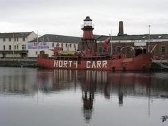
It was therefore a surprise when I reached City Quay and found Dundee to be reasonably nice place. I had not heard anything from the newspaper, so I spent half an hour looking around the Quay. It is dominated by two ships; the old North Carr Lightship, and HM Frigate Unicorn, which was built in 1824 and is the oldest British-built warship afloat. It is a quite a strange sight, as the masts have been removed and a wooden low-pitched roof placed over it. Unfortunately the ship did not open until ten, and by this time I had ventured further into the city centre. I was surprised to find that Dundee is the third largest city in Scotland, and I did quite like the centre. After a while the photographer turned up, and I did a simple photo shoot by a statue of a Unicorn near St Mary's Church.
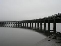
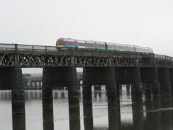
On the way out of the city I passed the RM Discovery, which is moored at Discovery Point. The rigging on this ship looked beautiful, and I walked around it as far as I could to look at it from all angles. The next thing of note was the Tay Railway Bridge, which I have seen many times in photographs for many years. It is notable for a couple of reasons; firstly, when it opened it was the longest rail bridge over tidal waters in the world, and secondly the present bridge is a replacement for the first, which collapsed shortly after it opened, killing 88 people. The engineer of the first bridge, Thomas Bouch, was ruined by the disaster when it was proved that the bridge had not been built strongly enough, and he was removed from the contract to design the Forth Bridge. The engineers who took over built the present-day Forth Bridge to a massively strong design, many times stronger than it need to be. This became known as the 'Bouch Factor', which means designing something to be many times stronger than it needs to be (i.e. some redundancy in the design), and is a term that I learnt years ago at university in London. The Tay Bridge is not the most elegant structure in the world, but it certainly does the job.
I met Sam for lunch in Kingoodie, and I must admit that it did not come too soon. The long break only an hour into the walk had knocked my routine out of whack, and I found it exceptionally hard to get going again. or the first time in ages I was tempted to stop the walk after only nine miles (although I had walked many miles around Dundee when my GPS had been switched off and thus these were not counted). I knew that it would be a shame to end the walk so early, so reluctantly I got up and se off once again.
The rest of the walk was along road and track westwards, and I rarely got to see the Tay estuary as I was always a mil or so inland from it. I had arranged to meet Sam at Errol, and as I had covered sixteen miles I decided to end the day there. From Errol I had planned to walk to the river and follow a path west into Perth from there, and the next place that I could be picked up from was a fair few miles away,and I did not fancy doing the walk this afternoon.
When I arrived Sam nipped out to the post office in the village to send some birthday cards, and when he was there she got the paper that had the interview and picture in that I had done this morning. This was probably the quickest time from interview to appearing in paper that I had on this trip - only a few hours! This evening we went out to the local pub, The Old Smiddy, where we enjoyed a little drink or two. Whilst we were in there I asked a few locals about the quality of the path beside the river into Perth, and they all recommended that I not try it, and I think that I will take their advice.
Directions
This walk starts off on a road by the seafront to the west of the town of Broughty Ferry. Head along the road until just before it turns to the right to climb over the railway line, and continue on along a cycle path that heads westwards between the sea and a railway line. After about a mile this cycle path ends at a road that can be followed on for a little under a kilometre as it curves to the right to end at a roundabout on the A930 Broughty Ferry Road. Turn left and follow the A930 westwards towards the centre of Dundee; on the way the A930 joins the A92(T) road.
When the A92(T) road meets a roundabout in the centre of the town turn left down an access road that leads to City Quay. Continue on past the western end of the dock to the riverfront, where there is a cycle path. Turn right and follow the cycle path westwards as it passes under the Tay Road Bridge, and continue on past Discovery Point. The path follows the A85 as it passes under the Tay Rail Bridge, after which it curves to the right and then left to skirt past Dundee Airport.
After a couple of miles the road climbs over a railway line. Immediately on the other side of the bridge turn left to go down a path that leads down to a road on a lower level. Turn right along this road and after a couple of hundred yards at a junction turn left and follow a road southwestwards past Invergowrie railway station until it ends at a T-junction.
At the T-junction turn left and follow the road as it leaves Invergowrie and climbs over the railway line. The road continues westwards through Kingoodie and onwards until Broomhall is reached on the right. Here turn left down a track that crosses a level crossing over a railway line and reaches Kingston Farm. Pass Kinston Farm and then turn right down a track that head southwestwards for over a kilometre until it ends at a T-junction with a road.
Turn right up this road and then almost immediately turn let down another road, which can be followed southwestwards for a few miles past Waterybutts and an old airfield to reach Errol. Walk through Errol and pass the church and post office until you reach the Old Smiddy Inn, where this walk ends.
Distances
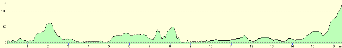
| From | To | Distance (m) | Ascent (ft) | Descent (ft) |
|---|---|---|---|---|
| Broughty Ferry | Dundee | 3.2 | 92 | 82 |
| Dundee | Kingoodie | 5.5 | 157 | 167 |
| Kingoodie | Errol | 7.8 | 207 | 79 |
This makes a total distance of 16.5 miles, with 456 feet of ascent and 328 feet of descent.
For more information on profiles, ascents and descents, see this page
Accommodation
We parked for the night on Elm Street in Errol, which was the best place that we could find in the village, which mostly comprises narrow streets. Sam thought that the street name was most worrying, and she hoped that she would not have a nightmare tonight!
Disclaimer
Please note that I take no responsibility for anything that may happen when following these directions. If you intend to follow this route, then please use the relevant maps and check the route out before you go out. As always when walking, use common sense and you should be fine.
If you find any information on any of these routes that is inaccurate, or you wish to add anything, then please email me.
All images on this site are © of the author. Any reproduction, retransmissions, or republication of all or part of any document found on this site is expressly prohibited, unless the author has explicitly granted its prior written consent to so reproduce, retransmit, or republish the material. All other rights reserved.
Although this site includes links providing convenient direct access to other Internet sites, I do not endorse, approve, certify or make warranties or representations as to the accuracy of the information on these sites.
And finally, enjoy your walking!
This walk was mentioned in the following routes:
| My walk around the coastline of Britain |
Nearby walks
| # | Title | Walk length (miles) |
|---|---|---|
| 556 | Seaton House to Broughty Ferry | 17.6 |
| 558 | Errol to Abernethy | 25.0 |
| 559 | Abernethy to Tayport | 20.9 |
|
|

|