Walk #559: Abernethy to Tayport
 |
 |
|
General Data
| Date Walked | 17/09/2003 |
| County | Tayside, Fife |
| Start Location | Abernethy |
| End Location | Tayport |
| Start time | 08.30 |
| End time | 16.24 |
| Distance | 20.9 miles |
| Description | This was a very mixed walk, with some fairly boring road plods being interspersed with some more interesting stretches as I made my way along the southern bank of the Tay. |
| Pack | Today I carried my 30-litre Karrimor HotRock rucksack, which was filled with my packed lunch, waterproof leggings, water bottle and a couple of spare shirts, together with the usual assortment of odds and ends. |
| Condition | I feel absolutely fine after this walk, and have no significant problems to report. My feet and ankles were fine, and I did not have many problems with my shoulder or neck. |
| Weather | The weather today was not too bad, with more sunshine that I had seen over the last few days. There was some cloud, however, and a slight breeze that helped cool me down. There was no sign of any rain, and it was an almost ideal day for a walk. |
| OS map | Landranger number 58 (Perth to Alloa, Auchterarder) and Landranger number 59 (St Andrews, Kirkcaldy & Glenrothes) |
 |
 |
|
 |
 |
|
Map of the walk
Maps courtesy of Google Maps. Route for indicative purposes only, and may have been plotted after the walk. Please let me have comments on what you think of this new format. For a detailed table of timings for this walk, please see the table file.
Notes
Last night I had been in two minds about whether to walk south from Abernethy towards Fife's highest point at West Lomond Hill, one of the highest points on my list of counties tops to be done. It seemed like an ideal opportunity to do this, but it would be ten miles there and back, and thus would be a twenty mile round trip. After much prevarication I decided not to do this, but it was a hard decision - I have enough time in hand to be able to spend a day doing the walk and the weather was nice, but I really could not face walking ten miles only to have to come back down the same way, when the hill could be put in a nice walk from the coast on the south side of Fife over to the Tay Estuary.
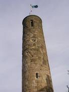
I knew that we were meeting up with my parents this evening, so I decided to try and hurry today so that we could spend more time together. In Abernethy I diverted slightly through the village so that I could have a look at the eleventh century Celtic round tower, one of only two in Scotland. It is a quite a impressive structure, quite tall and slender and it seems to the untrained eye to be quite well-preserved. In the square there is also quite a nice stepped war memorial, and the whole scene was quite nice.
On the way east into Newburgh I crossed over into Fife, which is the last complete county that I will walk on this trip (I have already walked part of the last county, East Lothian, at the start of the walk from Edinburgh). When I think about how many counties I have travelled through on this trip I find it quite amazing - from the long three-month slog around the Highlands to the couple of days in Tyne and Wear, they have all had their own characters and looks, and I held a little ceremony for myself a I stepped past the sign and entered Fife.
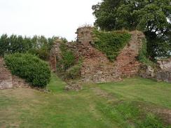
Newburgh was a surprisingly nice little town, although there was too much traffic running through the middle of it for my liking. I found my way down to the ruins of the abbey that are now in what appears to be a private garden. I looked over the wall and took some photos of the ruins, but they were hardly the most impressive abbey ruins that I have seen on the trip.
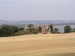
A long walk along roads and tracks took me to Balmerino, where Sam was waiting for me. The first part of this walk along roads was quite boring, the highlights being the view over the Tay Estuary to the north and a quick trip down to have a look at the ruins of the Old Flisk Church. Fortunately the last couple of miles from Birkhill House to Balmerino were far better, along a nice track that were easier on my feet. Sam made me some sandwiches for lunch and as I had walked a long way in the morning I decided to take a slightly extended lunch break. After lunch I went and had a quick look around the ruins of Balmerino Abbey. The ruins are far more substantial than those at Newburgh, although the most substantial parts are fenced off due to the danger of falling masonry, which was a shame, as I would not have minded looking around it in more detail. It cost a pound to enter the ruins, which was probably worth it.
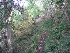
From Balmerino I followed a path that runs along the northern bank of the river eastwards towards Newport-on-Tay and the Tay rail bridge. This path made for a lovely walk, and shortly after I joined it I met a local man who was trimming some of the overgrowth. It was nice to see someone doing some footpath maintenance, and so I chatted to him for a while. It turns out that there is a footpath running through the woodland from Birkhill House to Balmerino that I could have followed, but that a section that used to exist from Flisk Point to Birkhill House has long ago become impassable. I did not mind missing that stretch of path, however, as the track that I followed was a good alternative and it would not have saved me from any of the road walking.
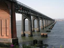
I soon reached the Tay Railway Bridge and Newport-on-Tay. The rail bridge is quite an impressive structure, and looks better from this southern bank than it did from the northern one. Beside the pillars of the new bridge were the seaweed-covered stumpy remains of the pillars of the old bridge, which collapsed killing 88 people one stormy night. I must admit that I was not that impressed with Newport-on-Tay - it did not look like that nice a place as I walked through it, and I was glad when I left the town and walked under the Tay Road bridge. The last couple of miles along the walk followed the start of the Fife Coastal Path that I will be following for much of the time to North Queensferry and the Forth Bridge. I had much the same impression about Tayport where Mervan was waiting for me, although the area around the harbour was quite nice, although with some dreary buildings behind it.
My parents arrived about five minutes after I did, and as we were not expecting them so early I quickly had to spray myself with deodorant and chuck a new t-shirt on so that I was not too smelly. It was the first time that we had seen them for a few months, and it was great to be able to chat to them again - although I was depressed that it was a sign that the walk was coming to an end. It was our intention to go out for a meal, but we could not see a nice place in Tayport and so mum and dad enquired in a local shop. In the end we drove to an inn called St Michaels, which is in the village of St Michaels four or five miles away. We had a lovely meal, although I was very tired and kept on switching off every so often during the meal.
Directions
This walk starts off by the A913 road in the village of Abernethy. Head northeastwards along the road out of the village and follow it for three miles to the village of Newburgh. Walk through the village and then turn left down a road that leads past Newburgh Abbey and then climbs up northeastwards along the flank of a hill, passing Parkhill and Ballinbreich Farm (with the castle by the shore below), Logie Farm, Balhevie and East Flisk. A little under a kilometre east of East Flisk turn left down a surfaced track that leads through a gateway and heads down towards Birkhill House.
when the track splits before Birkhill House is reached turn right and follow an unsurfaced track around to the right past a house and uphill slightly. The track then skirts northeastwards along the hillside past Thornton before ending at a road near Byres. Turn left down this road for a couple of hundred yards and the turn left to head north down a road that passes Balmerino Abbey.
When the road curves to the right turn left down a track that heads northwards to meets the southern shore of the Firth. Follow the track along the shore for a couple of hundred yards and when it ends take an obvious path that heads between some houses at Maw Craig and the shore. The path is easy to follow as it heads through some woodland eastwards, with occasional good views over the Firth, until it eventually drops down and meets a track to the west of Wormit.
Join the track and follow it eastwards as it joins a road that climbs up to pass under the southern viaduct that lead to the Tay rail bridge and then ends at the B946 road. Follow this road northeastwards through the centre of Newport-on-Tay and onwards out of the town, where it passes under the Tay Road Bridge.
A short distance after the bridge a cycle path head off to the left; initially this follows the road before joining the trackbed of an old railway line and heading down the hillside past a cemetery and near to a lighthouse. When a missing bridge on the trackbed is reached turn left to drop down onto a track, which can be followed eastwards past a disused lighthouse and onwards into Tayport. Follow the path signs down into Tayport Harbour, where this walk ends.
Distances
| From | To | Distance (m) | Ascent (ft) | Descent (ft) |
|---|---|---|---|---|
| Abernethy | Newburgh Abbey | 4.0 | 157 | 220 |
| Newburgh Abbey | Balmerino Abbey | 9.3 | 732 | 696 |
| Balmerino Abbey | Tayport | 7.6 | 781 | 846 |
This makes a total distance of 20.9 miles, with 1670 feet of ascent and 1762 feet of descent.
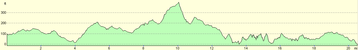
For more information on profiles, ascents and descents, see this page
Accommodation
We spent the night parked in a car park by the harbour in Tayport, which was a reasonable place to spend the night and had some lovely views over the harbour and Tay to Broughty Ferry, where we had parked two nights ago. There were some public toilets right next door to where we parked, but these were locked before six this evening.
Disclaimer
Please note that I take no responsibility for anything that may happen when following these directions. If you intend to follow this route, then please use the relevant maps and check the route out before you go out. As always when walking, use common sense and you should be fine.
If you find any information on any of these routes that is inaccurate, or you wish to add anything, then please email me.
All images on this site are © of the author. Any reproduction, retransmissions, or republication of all or part of any document found on this site is expressly prohibited, unless the author has explicitly granted its prior written consent to so reproduce, retransmit, or republish the material. All other rights reserved.
Although this site includes links providing convenient direct access to other Internet sites, I do not endorse, approve, certify or make warranties or representations as to the accuracy of the information on these sites.
And finally, enjoy your walking!
This walk was mentioned in the following routes:
| My walk around the coastline of Britain |
Nearby walks
| # | Title | Walk length (miles) |
|---|---|---|
| 557 | Broughty Ferry to Errol | 16.5 |
| 558 | Errol to Abernethy | 25.0 |
|
|

|