Walk #290: Faversham to Reculver
 |
 |
|
General Data
| Date Walked | 08/12/2002 |
| County | Kent |
| Start Location | Faversham Station |
| End Location | Reculver |
| Start time | 08.00 |
| End time | 15.23 |
| Distance | 17.8 miles |
| Description | This was a lovely walk following the coast eastwards from Faversham through Whitstable and Herne Bay. This is the last full day of eastwards walking I will be doing before turning the corner and heading westwards along the south coast. |
| Pack | I did not wear a pack today as I was meeting Sam for lunch. Everything that I needed with me for the day I put in my coat, which meant that it weighted much more than usual. |
| Condition | I feel absolutely fine after this walk. I had next to no problems with my ankle, and the only problem I have to report was some aching in my right shoulder and some nasty chaffing on my right Achilles, which is a recurrence of a problem that I had a few weeks ago. |
| Weather | It was a very grey day today, with no sign of any sun being visible through the thick cloud layer. There was not much rain, only a couple of minutes of drizzle that did not even start to get me wet. There was a little breeze, but not enough to annoy me. The worst thing about today was the temperature, as it started off very cold and did not really heat up at all during the day. My feet were very cold at the start of the walk, and it took a couple of hours for my toes to warm up. |
| OS map | Landranger number 178 (Thames Estuary, Rochester & Southend-on-Sea) and Landranger number 179 (Canterbury & East Kent, Dover & Margate) |
 |
 |
|
 |
 |
|
Map of the walk
Maps courtesy of Google Maps. Route for indicative purposes only, and may have been plotted after the walk. Please let me have comments on what you think of this new format. For a detailed table of timings for this walk, please see the table file.
 |
Notes
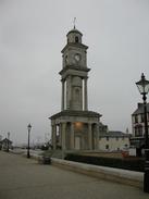
As I was walking along the coast towards Herne Bay I could see a structure out to sea, and as I got closer I realised that this was the seaward end of Herne Bay pier. It is a very unusual sight, as the rest of the pier from the shore was destroyed in a storm in the seventies, leaving only the two extreme ends. The pier used to be 3,920 feet long, and was the second longest pier in the country behind Clacton's. It is a real shame to see what must have been a magnificent structure in ruins, and it made me even more glad that Clacton pier has survived all its travails. The same storm that wrecked Herne Bay pier also wrecked Margate pier, which I shall pass tomorrow. The end of the pier pout at sea made a very sad sight, and I wonder what, if anything, the end section is used for nowadays. Herne Bay itself was built after a proposal by a group of businessmen for a new town to be built called 'St Augustine', and by 1831 the first pier had been built.
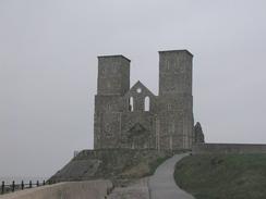
Passing Herne Bay I started to be able to see two towers along the coast ahead of me. These are the two towers of Saint Mary's Church at Reculver. The church was founded by King Egbert of Kent in 669 and is based within the walls of the third century Roman fort of Regulbium, which controlled the northern entrance to the Wantsum channel that separated the Isle of Thanet from the mainland. Most of the fort has now been lost to the sea, but some of the walls remain up to three metres high and are an impressive sight. This is illustrative at how fast the cliffs are being eroded, as it is believed that the fort was built two kilometres away from the sea! The towers of the church are such an important navigational landmark that they were repaired in 1809 after they were damaged in a gale., despite the rest of the church having been demolished.
Sam had made spaghetti bolognaise for dinner last night, and after we had eaten our fill there was still plenty left. For this reason we agreed to meet up at lunchtime in Whitstable so that I could have the leftovers for lunch. About half a mile away from Whitstable I met Sam, who had walked down to meet me, and she directed me to the van, which was parked some distance away from the seafront in a car park. Whilst Sam reheated the spaghetti I skimmed through the paper to see what had been happening in the world before I wolfed it ravenously down. This was an excellent way to spend lunch, and beat having a pint in a pub. Unfortunately about an hour after lunch I realised that I really had to go to the toilet, so I was forced to nip into the Hampton Inn in Hampton for a pint so that I could use their facilities. It was nice to have a relaxing day in which I managed to walk a nice distance despite having several stops, especially as the days are getting progressively shorter. I find that having a stop allows me to relax more and ends up stressing my body less, although the first five minutes after a stop are painful as my Achilles and legs ache.
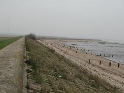
The cliffs to the east of Herne Bay were the first real cliffs that I had encountered in ages - probably since the Southwold area in Suffolk, and the first chalk cliffs since Flamborough Head. It is nice to be on a totally new sort of terrain, and for the next few weeks cliffs should take over from sea walls, which will make the going harder.
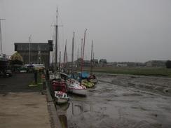
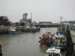
Whitstable Harbour is the terminus of the Canterbury and Whitstable Railway, which was one of the first passenger railways in the country and opened on the third of May 1830, beating the much more famous Liverpool and Manchester railway by a few months. Initially the line used static winding engines to pull the trains, but the line was unsuccessful and the engines were replaced with locomotives when the company was taken over by the South Eastern Railway Company in 1843. British Railways shut the line in 1952, and despite it reopening for a short period after the floods in 1953 little now remains of the railway in Whitstable.
When I was arranging where to meet Sam for lunch, I complained about how bitterly cold my neck was getting. We are looking for a knitted balaclava that I can wear, as my thin one does not do much good when it is windy, but we have not yet been able to find one. When I met Sam she was carrying a bright red muff with her, and I spent the rest of the day wearing this around my neck, ears and mouth to keep them warm. This worked quite well in combination with my woolly hat, as only a narrow band around my eyes was exposed to the cold.
Directions
This walk starts off at Faversham Station and follows the Saxon Shore Way. Turn right out of the station and follow the main road as it curves to the left, to head northwards path the library. Continue on along the road as it curves to the left and then to the right, and when it turns to the left once more near the church continue straight on down Abbey Road. When this road ends at a T-junction turn left and then right to head behind a quay, before joinging a path that heads along the eastern bank of Faversham Creek.
Follow the path as it heads northeastwards, passing a farm at Nagden and turning to head northwestwards along the southern edge of the Nagden Marshes. The path then turns to head northwards beside Faversham Creek before meeting The Swale. Here the bank turns to the right and becomes a seawall as it heads eastwards for a couple of miles, passing Cleve Marshes before reaching some houses at Graveney. Here a road runs alongside the seawall for a couple of kilometres, with the footpath between the two until Seasalter is reached.
In Seasalter the road turns to the right to head inland and the footpath continues on beside the seawall. At some private residences the Saxon Shore Way diverts inland, but I continued on along the beach northeastwards into Whitstable, as it was low tide. In Whitstable pass the harbour and rejoin the sea wall. Follow this eastwards towards Swalecliffe and then on for another mile to Hampton. Another couple of kilometres further on Herne Bay is reached.
Walk past the pier in Herne Bay and follow the seawall eastwards for nearly three kilometres until just before it ends. Here a path leads up the cliffs to the right, leading to a car park in Bishopstone. In the car park a path leads off to the left to head eastwards slightly away from the top of the cliffs, and again following the Saxon Shore Way. This path continues on for a little over a mile, ascending and descending with the cliffs until the car park in Reculver is reached, where this walk ends.
Distances
| From | To | Distance (m) | Ascent (ft) | Descent (ft) |
|---|---|---|---|---|
| Faversham Station | Whitstable | 9.7 | 105 | 151 |
| Whitstable | Reculver | 8.1 | 279 | 276 |
This makes a total distance of 17.8 miles, with 384 feet of ascent and 427 feet of descent.
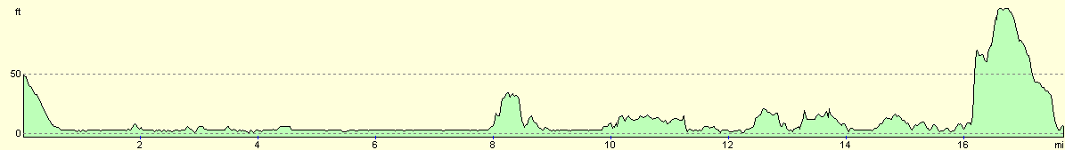
For more information on profiles, ascents and descents, see this page
Accommodation
We spent the night at Clayhanger Hall, Chislet Forstal, Canterbury CT3 4DT. This was a very nice campsite, which was convenient for the finishing point of the walk. The site cost seven pounds for the night, but the owner kindly donated the money to the charity. They can be contacted on (01227) 860346 and is situated at grid reference TR 217641.
Disclaimer
Please note that I take no responsibility for anything that may happen when following these directions. If you intend to follow this route, then please use the relevant maps and check the route out before you go out. As always when walking, use common sense and you should be fine.
If you find any information on any of these routes that is inaccurate, or you wish to add anything, then please email me.
All images on this site are © of the author. Any reproduction, retransmissions, or republication of all or part of any document found on this site is expressly prohibited, unless the author has explicitly granted its prior written consent to so reproduce, retransmit, or republish the material. All other rights reserved.
Although this site includes links providing convenient direct access to other Internet sites, I do not endorse, approve, certify or make warranties or representations as to the accuracy of the information on these sites.
And finally, enjoy your walking!
This walk was mentioned in the following routes:
| My walk around the coastline of Britain |
Nearby walks
| # | Title | Walk length (miles) |
|---|---|---|
| 179 | Sittingbourne to Faversham | 13.9 |
| 289 | Sittingbourne to Faversham | 16.3 |
| 291 | Reculver to Ramsgate | 17.4 |
|
|

|