Walk #541: Cromarty to Munlochy
 |
 |
|
General Data
| Date Walked | 29/08/2003 |
| County | Highlands |
| Start Location | Cromarty |
| End Location | Munlochy |
| Start time | 08.43 |
| End time | 17.32 |
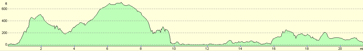
| Distance | 21.8 miles |
| Description | This was an annoyingly frustrating walk, although thankfully there was not too much road walking. |
| Pack | Today I carried my 30-litre Karrimor HotRock rucksack, which was filled with my packed lunch, waterproof leggings, water bottle and a couple of spare shirts, together with the usual assortment of odds and ends. |
| Condition | I feel absolutely fine after this walk, and have no significant problems to report. My right foot gave a few twinges during the day, but none of these were long lasting. |
| Weather | Today was another day of sunshine and showers, although thankfully none of the showers were too heavy or prolonged, particularly when compared to yesterday. The day was a bit warmer than yesterday, although it was cold at times when the rain was falling. All in all it was far from perfect, but it could have been far worse. |
| OS map | Landranger number 27 (Nairn & Forres, River Findhorn) and Landranger number 26 (Inverness & Loch Ness) |
 |
 |
|
 |
 |
|
Map of the walk
Maps courtesy of Google Maps. Route for indicative purposes only, and may have been plotted after the walk. Please let me have comments on what you think of this new format. For a detailed table of timings for this walk, please see the table file.
Notes
I woke up this morning in a good mood, and after watching the news on the television for a few minutes I got down to some work. A couple of cups of coffee helped me to concentrate, and I managed to get a decent amount of work done. I always operate better in the mornings that I do in the evenings, and I much prefer typing notes on my Psion in the mornings when I am fresh that I do in the evenings when I am tired after a long days walk. Because I got lots of work done I could start the walk early with a spring in my step, and I enjoyed the early morning sunshine as I set off through Cromarty.
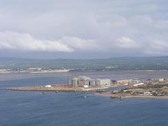
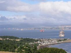
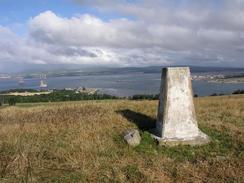
The path up to the Sutors of Cromarty was of good quality, and despite the steps up the side of the hill I made good time to the top. The view west along the Firth of Cromarty and the moored oil rigs was superb, and I also got some nice views south over the Moray Firth to the Grampian coast. At the top I decided that instead of following the track along the south side of the cliffs I would go to the trig point at the top of Gallow Hill, where the views should be more expansive. When I reached there the views were so good I took a panoramic photograph, which I hope will come out okay.
I then pressed on down the crest of the hill and through the middle of a narrow band of woodland before reaching the valley near St Bennet's Well, where I followed the top of the cliffs southwestwards. Here things started to go slightly wrong. On the map there is a path heading down the hill from the farm at Navity that reached the edge of the cliffs before heading down onto the foreshore, where it can be followed southwestwards all the way to Rosemarkie. I found the place where the track met the clifftop easily, but after five minutes searching I could not find where it headed down the steep cliffs - the whole area was extremely overgrown with brambles, bracken and other vegetation. The cliffs were quiet steep, and as it was so overgrown it was hard to see the exact lie of the land. Because of all this I decided that it was best to try and make my own way down, so I had to follow the edge of the cliffs southwestwards until I met the road near Eathie Mains.
I followed the road southwestwards until I got near to the farm at Balmungie, where a track is shown on the map heading down the cliffs to the foreshore. I went down the track, but again I could not find the point where it dropped down the cliffs. At the point where it is supposed to go down the cliffs appeared to be sheer, and I walked to and fro trying to find the way down. After a few minutes I had not found it, and so I walked southwestwards along the top of the cliffs, climbing over many fences and crossing many fields. The top of the cliffs slowly get lower, until I eventually reached a distinct path below a cottage which I could follow down to the beach and the foreshore on the outskirts of Rosemarkie.
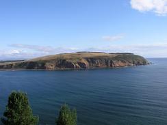
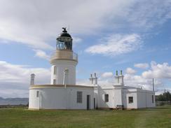
The walk from Rosemarkie to the lighthouse at Chanonry Point took me past a golf course beside the foreshore, and it was nice to be able to rest my legs by walking on a proper path instead of having to climb over fences every hundred yards. The Moray Firth at this point is very narrow, and I could clearly make out the walls of Fort George under a mile away on the southern side of the Firth. I explored the area around the lighthouse for a while before treating myself to an ice cream and heading back off along the path to Fortrose.
Sam was waiting for me by the ruins of the cathedral in Fortrose, which is quite an impressive little ruin Unfortunately we could not go inside the roofless remains as some work was being done, but instead we went into the Royal Hotel for a quick drink. Outside the hotel we met a couple who we had met on Monday afternoon at Portmahomack, which reminds me about quite how far I have walked in the last few days. The pint of Belhaven went down well, and Sam's company helped cheer me up after the rather depressing mornings walk. It is quite annoying that there are many signs showing the paths on the black Isle in the area, but it seems like nothing has been done to make it passable. These paths should make for some great walks if only some work was done on them - perversely they may be much more passable earlier in the year when the vegetation is not so high. The route may also be tidal - the path along the base of the cliffs may not be passable at high tide.
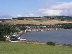
The long road walk southwestwards from Fortrose to Avoch was not very nice as the road was surprisingly busy and it was quite narrow. I was glad when I reached the harbour at Avoch and I could divert away along some minor roads. I had arranged to meet Sam ain Munlochy, but to get there I had to walk around Ormond Hill. As I approached this from the north I could see that it was dominated by the mound of Ormond Castle, of which sadly no stonework remains (the stone was removed for use in the construction of Fort George). The rest of the walk was fairly straightforward, except for five minutes when I hid under some trees during a particularly sharp shower.
I always get slightly guilty about where we park at night. Tonight, being in a church car park, being a classic case. After the three times we have been nastily moved on during this trip we are both paranoid about where we park, and this can rather spoil the evening. Fortunately tonight the local reverend turned up, and he kindly allowed us to stay here, which was very kind as there was not really anywhere else to park.
I am undecided about what I am going to do tomorrow. Sam is going to Edinburgh by train first thing on Monday morning, and on that day I will have to walk from Inverness towards Nairn and Forres. This means that I shall have to end Sunday's walk at Inverness, which is a little over a day's walk away at the pace that I have been going over the last few weeks. I am loathed to do two short days, and so I may do a long day tomorrow, and on Sunday walk into Inverness and then do a circular walk around the town, ending up in the city, and thus extending the walk. This is a shame, but it seems like it will be the best solution. As usual, however, my plans may change!
Directions
This walk starts off at a little car park by Shore Street in Cromarty. Head southeastwards along the road through the town until it turns sharply to the right near a cottage. At this bend turn left along a good quality footpath that skirts the foreshore as it heads eastwards before starting to climb uphill using steps before eventually reaching a car park at the Sutors of Cromarty. Instead of heading downhill towards some buildings I turned to the right and went over a gate to reach some old, ruined, military buildings. I then went southwestwards along a broad ridge to reach the trig point on the top of Gallow Hill.
From the top of Gallow Hill I headed southwestwards across fields, skirting the top of a small area of woodland above McFarquhar's Cave and reaching a much larger area of woodland. I found a slight gap in this woodland that allowed me to walk through the middle of it, and hence gain access to the fields on the western side, near a little valley and St Bennet's Well. I then followed the cliffs along for a short distance until I reached a track that leads southeastwards from the farm at Navity. On the map a path leads down to the foreshore here, but I could not find this and so I followed the edge of the cliff along until I reached a road beside a barn.
At the road turn left and follow it southwestwards. It passes a farm at Eathie Mains and climb uphill through some woodland and past a large mast. It slowly descends downhill and leaves the woodland, until just before a track to Hillockhead leaves to the left I turned left down another track that leads past Balmungie towards an area of woodland by a stream. Here again there is meant to be a path leading down the cliffs, and again I could not find it, so I had to follow the edge of the cliffs southwestwards across some fields. The cliffs slowly become lower, and I eventually reached a path that allowed me to access the foreshore immediately to the north of Rosemarkie.
Join the road in Rosemarkie and follow it around past a campsite. When the road curves to the right join a path that heads southeastwards beside the foreshore, passing a golf course before reaching the lighthouse at Chanonry Point. Just before the lighthouse is reached turn right down a track that leads across the narrow peninsular to a car park on the southern side. Turn right and walk along a path beside the golf course until it reaches a campsite and a road. Head westwards along the road as it passes a school and a cathedral until it ends at a T-junction with the A832 road in Fortrose.
Turn left and walk southwestwards along the A832 road for a couple of kilometres until the harbour in Avoch is reached. Immediately past the harbour take a road that leads off to the left and follows the foreshore around into Crosshill. The road then curves up to the right to head uphill past an industrial estate; head up this road and then turn left along a track that leads towards the farm at Castleton. When the track curves to the right to enter the farm turn left down a green track that heads southeastwards towards the mound of Ormond Castle. Follow the track as it enters some forestry and skirts around the southern side of the mound and Ormond Hill. Eventually the track exits the woodland and end at a T-junction with a road.
Turn left along the road and follow it as it becomes a track and passes the entrance to the farm at Ballone and on through some woodland to Bay Farm. It then curves uphill and continues northeastwards before ending at a T-junction with a track. At the junction turn left and follow another track westwards for a few hundred yards until it ends at a wooded area on Ord Hill. At the end of the track turn right and descend northwestwards across a couple of fields to reach the A832 road. Turn left to walk westwards along the A832 road; this was fairly busy so when an old railway embankment became visible on the left I joined this and followed it as it paralleled the road until it ended, dumping me back onto the A832. At the junction with the B9161 road turn left and follow the road through the little village of Munlochy until you reach a left-hand bend; on the far side of this bend is Munlochy Church, where this walk ends.
Distances
| From | To | Distance (m) | Ascent (ft) | Descent (ft) |
|---|---|---|---|---|
| Cromarty | Chanonry Point lighthouse | 12.1 | 1713 | 1713 |
| Chanonry Point lighthouse | Munlochy Church | 9.7 | 912 | 886 |
This makes a total distance of 21.8 miles, with 2625 feet of ascent and 2599 feet of descent.
For more information on profiles, ascents and descents, see this page
Accommodation
We spent the night in the car park of the Knockrain Church of Scotland in Munlochy, which was the largest flat place that we could find to park. This was quite handy for the shop and the pub, which was quite nice.
Disclaimer
Please note that I take no responsibility for anything that may happen when following these directions. If you intend to follow this route, then please use the relevant maps and check the route out before you go out. As always when walking, use common sense and you should be fine.
If you find any information on any of these routes that is inaccurate, or you wish to add anything, then please email me.
All images on this site are © of the author. Any reproduction, retransmissions, or republication of all or part of any document found on this site is expressly prohibited, unless the author has explicitly granted its prior written consent to so reproduce, retransmit, or republish the material. All other rights reserved.
Although this site includes links providing convenient direct access to other Internet sites, I do not endorse, approve, certify or make warranties or representations as to the accuracy of the information on these sites.
And finally, enjoy your walking!
This walk was mentioned in the following routes:
| My walk around the coastline of Britain |
Nearby walks
| # | Title | Walk length (miles) |
|---|---|---|
| 538 | Rockfield to Arabella | 19.3 |
| 539 | Arabella to Dingwall | 22.8 |
| 540 | Dingwall to Cromarty | 24.0 |
|
|

|