Walk #538: Rockfield to Arabella
 |
 |
|
General Data
| Date Walked | 26/08/2003 |
| County | Highlands |
| Start Location | Rockfield |
| End Location | Arabella |
| Start time | 09.19 |
| End time | 17.40 |
| Distance | 19.3 miles |
| Description | This was quite a strenuous nut enjoyable days walk, with some expansive views available from the top of the Hill of Nigg. |
| Pack | Today I carried my 30-litre Karrimor HotRock rucksack, which was filled with my packed lunch, waterproof leggings, water bottle and a couple of spare shirts, together with the usual assortment of odds and ends. |
| Condition | I am quite fatigued after this walk, but aside from this I feel relatively okay. My right foot did not give me much trouble, but my right shoulder did ache at times. |
| Weather | Today started off quite grey, but as it progressed the cloud slowly lifted leaving a beautifully sunny day. There was not much wind, and this made it a lovely day for walking. |
| OS map | Landranger number 21 (Dornoch & Alness, Invergordon & Tain) |
 |
 |
|
 |
 |
|
Map of the walk
Maps courtesy of Google Maps. Route for indicative purposes only, and may have been plotted after the walk. Please let me have comments on what you think of this new format. For a detailed table of timings for this walk, please see the table file.
Notes
I woke up quite late this morning, which is probably a symptom of the relatively late evening that I had last night. Going to bed at a little past ten may not seem late to some people, but after a long day's walk I was extremely tired and ready for bed. Because I woke up late I was very disoriented when I finally did get up, and it took two rapid cups of coffee to ease the situation.
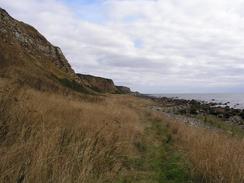
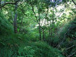
Sam drove me back to the top of the hill above the tiny village of Rockfield (where I finished yesterday's walk) so that she would not have to drive me down the steep hill into the village. I soon walked down the hill and started the walk proper, which initially passed along the linear road through the village before becoming a path along the foreshore below the cliffs. This made for good walking with some extremely nice views available over the Firth of Cromarty, but I soon came to a little problem. At one point I reached a little hut and the path became a track that led up onto the top of the cliffs. I followed this track onto the top of the cliffs, herding some highland cows in front of me, and I then tried to make my way along the top of the cliffs through an area of woodland. This was easy enough, but when the forestry ended I was greeted with a ten foot drop down to a stream, with thick gorse carpeting the sides. I did not fancy climbing down this, so I had to walk inland to get to a place where there was no gorse to cross the stream, and gain access to the track that led back to the foreshore.
Hilton of Cadboll and Balintore are two villages that are joined together and it is hard to find out where one starts and the other ends. I nipped into the local shop to find it festooned with decorations - a lady who was working there was celebrating her fiftieth birthday. The harbour area was quite nice, and I stopped for a few minutes to readjust the sock in my left boot.
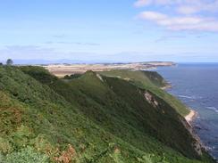
The next stretch of walk was across the top of the Hill of Nigg and down to Nigg Ferry. A sign by the harbour in Balintore stated that there was a path over the hills between the two places, and indeed once I had gone a mile I started to find regular tall posts marking the route. These were the first marker posts that I have seen on any path for ages, and in theory this should have made the walk easy. Unfortunately this was not the case, as the ground between the posts was, in places, extremely rough and overgrown. In places the bracken was higher than my head as it grew above me on the slope, and beside it was high and prickly gorse bushes. Small patches of this are manageable, but having to walk along miles of path like it does get wearisome to say the least. When I got to the deep valley that carries the outfall from Bayfield Loch to the sea I was greeted with a carpet of heather and no obvious path down. The arrow on the post by the stile was no help, and so I carefully made my way down the very steep slope. Once at the bottom I had to get onto my hands and knees to get up the other side, and eventually I found another stile and post indicating that I was once again on the correct route.
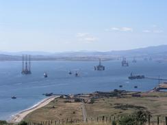
Unfortunately this was very much what the rest of the terrain was like. It made for quite hard going, and the vegetation also slowed me down considerably. This was a shame, as the route would make for a first-class walk if you did not have to wade through the vegetation. The entire walk from Tarbat Ness lighthouse to Nigg Ferry would be superb, and it is a shame that this section is so overgrown. I soon found that I could not find the path again through the vegetation (mainly as there was a stile that lead into dense bracken with no sign of any path). This disheartened me, and so I made my way to a little track hat lead towards a farm at Castlecraig and then onto a road that led steeply downhill to the B9175 road to Nigg Ferry. The views from this road were quite memorable, not only for the expansive views over the Cromarty Firth but also for the seven redundant oil rig that were moored in the firth. These gargantuan structures could be seen for miles, and they made for an amazing sight.
Nigg Ferry was the sight of a major oil rig construction site, and the buildings and massive cranes are still in use. There is a large graving dock in front of them, and I could imagine the rigs being 'launched' into the sea. Sam was waiting for me in the car park beside the Inn at Nigg Ferry, and I ate some sandwiches whilst we watched the ferry go to and fro across the Firth to Cromarty. From Nigg Ferry I simply walked northwards along the B9175 road, a fairly boring walk with one highlight; I have not seen any blackberries all summer, but now that I am heading southwards I am seeing some; my first ones a couple of days ago, and by the road today there were some ripe ones. I ate a couple and walked on, eventually meeting Sam at a road junction in Arabella.
I was quite disappointed that I did not manage to walk twenty miles today, as I had walked that far on each of the last five days of walking. I did do over nineteen miles, however, which is not a bad total and it is a good sign that I take nineteen miles to be a short day! If the weather is okay then tomorrow I will probably try and make up for today and do quite a long day; it will be a road walk all the way, and so I should be able to keep up a good pace.
Directions
This walk starts off at the northern end of the little village of Rockfield. Walk southwestwards along the road for a few hundred yards until the road ends, and when it does go through a gate and join a distinct path that heads along the foreshore under the cliffs. After a couple of miles a little hut is reached; here I climbed uphill along the track and fought my way through some forested land at the top of the cliffs before joining another track at headed down to the foreshore once again; it may well be easier and better to remain on the foreshore as the route that I took was hardly ideal.
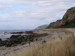
The path continues southwestwards along the foreshore, passing under Geannies House before reaching a little cottage under the cliffs. From here the path becomes slightly more distinct as it meets fields and eventually ends at a road on the northern outskirts of Hilton of Caddboll. Join the road and follow it as it heads southwestwards along the foreshore and enters Balintore. Pass the attractive harbour and continue on along the road as it skirts Shandwick Bay. Shortly beyond a phone box turn left down a small road and then immediately turn right up a track that leads uphill to the farm at Old Shandwick. Skirt the farm, and then take a track that leads uphill, turning to the right for a couple of hundred yards before turning to the left to reach a series of old ruined army buildings. Continue on to the southwest, and push through a gorse hedge to gain access to another field.
Here the route that I took joins a waymarked path that leads al the way southwestwards to Nigg Ferry. Unfortunately although the path was well waymarked (with tall posts and arrows indicating the way the path goes) it was extremely overgrown in places, and this made some descents quite dangerous. The path drops steeply down into one little valley, before climbing uphill. It then follows a fence line along the top of the cliffs until it reaches the deep valley that carries the outfall from Bayfield Loch. Here the path drops steeply downhill into the valley, but the path was densely overgrown and I went straight down the hill; this was slightly dangerous and the climb up the other side was difficult. When I got to the top I discovered that the path angled inland; take great care here.
More vegetation blocked progress in places, and when I reached a steep-sided channel near grid reference 833704 I was fed up, and instead of crossing the channel through the vegetation I headed inland to the southwest to meet the end of a track. This leads southwestwards for about a kilometre, passing a farm before ending at a T-junction with a public road. Turn left and follow this road south for a few hundred yards, when it then turns to the right at Castlecraig to head westwards. The road heads on for about two kilometres, going steeply downhill before it ends at a T-junction with the B9175 road at Nigg Ferry. If you want to visit the pub or the ferry then turn left down the B9175 for a couple of hundred yards; otherwise turn right.
Follow the B9175 road as it heads northwards, passing to the right of a large construction yard and the large tanks and bund walls of an oil terminal. After these the road meets the side of Nigg Bay, which it skirts for a couple of kilometres before leaving it near Pitcalnie and heads inland to the northeast. At Ankerville Corner the road curves to the left to head northwestwards for another couple of kilometre into Arabella, and this road ends at the junction with the road leading to Kildary on the left.
Distances
| From | To | Distance (m) | Ascent (ft) | Descent (ft) |
|---|---|---|---|---|
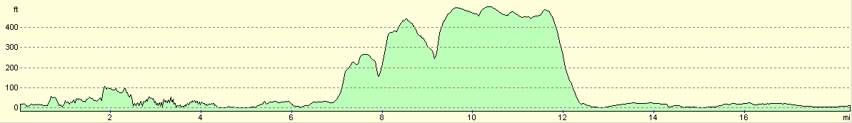
| Rockfield | Balintore Harbour | 6.5 | 554 | 568 |
| Balintore Harbour | Nigg Ferry | 7.3 | 942 | 942 |
| Nigg Ferry | Arabella | 5.5 | 112 | 102 |
This makes a total distance of 19.3 miles, with 1608 feet of ascent and 1612 feet of descent.
For more information on profiles, ascents and descents, see this page
Accommodation
We spent the night at a little car park opposite the shop by the junction with the road to Kildary in Arabella. This was a fairly quite place to spend the night, and the road was not too busy or noisy.
Disclaimer
Please note that I take no responsibility for anything that may happen when following these directions. If you intend to follow this route, then please use the relevant maps and check the route out before you go out. As always when walking, use common sense and you should be fine.
If you find any information on any of these routes that is inaccurate, or you wish to add anything, then please email me.
All images on this site are © of the author. Any reproduction, retransmissions, or republication of all or part of any document found on this site is expressly prohibited, unless the author has explicitly granted its prior written consent to so reproduce, retransmit, or republish the material. All other rights reserved.
Although this site includes links providing convenient direct access to other Internet sites, I do not endorse, approve, certify or make warranties or representations as to the accuracy of the information on these sites.
And finally, enjoy your walking!
This walk was mentioned in the following routes:
| My walk around the coastline of Britain |
Nearby walks
| # | Title | Walk length (miles) |
|---|---|---|
| 537 | Dornoch Bridge Inn to Rockfield | 20.9 |
| 539 | Arabella to Dingwall | 22.8 |
| 540 | Dingwall to Cromarty | 24.0 |
|
|

|