Walk #539: Arabella to Dingwall
 |
 |
|
General Data
| Date Walked | 27/08/2003 |
| County | Highlands |
| Start Location | Arabella |
| End Location | Dingwall |
| Start time | 07.22 |
| End time | 17.11 |
| Distance | 22.8 miles |
| Description | This was a long and fairly uninteresting road plod, which was enlivened and made memorable by a chance encounter. |
| Pack | Today I carried my 30-litre Karrimor HotRock rucksack, which was filled with my packed lunch, waterproof leggings, water bottle and a couple of spare shirts, together with the usual assortment of odds and ends. |
| Condition | I feel more or less okay after this walk. The worst problem that I had was with my right foot, which gave me trouble occasionally, although it was nowhere near as bad as it had been on Sunday. |
| Weather | The weather today started of grey, and first thing in the morning there were a couple of light showers that forced me to put my coat on. These soon cleared up and the rest of the day was dry and sunny, but towards the end of the afternoon grey clouds came over and for the last hour of the walk I was treated to a soaking. It was not a cold day and there was not much wind, so this was not as bad as it could have been. |
| OS map | Landranger number 21 (Dornoch & Alness, Invergordon & Tain) and Landranger number 26 (Inverness & Loch Ness) |
 |
 |
|
 |
Map of the walk
Maps courtesy of Google Maps. Route for indicative purposes only, and may have been plotted after the walk. Please let me have comments on what you think of this new format. For a detailed table of timings for this walk, please see the table file.
Notes
I started walking early this morning, as I realised that I had a long way to go to reach the campsite in Dingwall. The skies were grey, but it was dry and so I decided to start walking without my coat on. Because it was only seven in the morning it was quite cool, and I went to the shop across the road from the car park where we spent the night to have a look around. I ended up buying myself a bar of Highland Toffee and a chocolate bar, and set off on the walk. Unfortunately within five minutes of setting off it started to spit with rain, and as it got heavier I stopped and put my coat on - a good decision, as there was a bit of a downpour before it eventually stopped. This stretch of road walk was fairly nondescript, and I listened to the 'Today' program on Radio 4 to keep my mind occupied from the boredom. I had arranged to meet Sam in the village of Barbaraville for breakfast, and I had covered about five miles by the time that Mervan came into view in the village. It is a really nice feeling to be able to get five or six miles under my belt before nine in the morning, as I feel far less stressed about getting miles completed by the end of the day. If it had not been for the fact hat I am often writing up this website in the mornings I could have seen myself having had far more early starts on this walk, although maybe not the five o'clock starts that Graham has been having due to the hot weather recently!
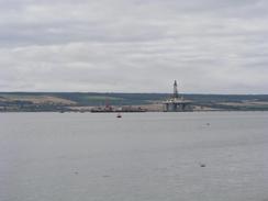
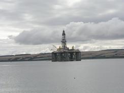
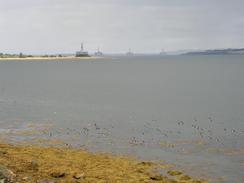
Sam was waiting for me in Barbaraville, and I entered Mervan for a quick bite of breakfast and another coffee, which was exceedingly welcome. By now the rain had stopped, but I decided to leave my coat on until lunchtime as it looked as though it could rain at any time. The walk through to Invergordon was quite nondescript, the highpoint being the sight of a large ship, the 'Columbus', moored by the pier, and of all the oilrigs in the Cromarty Firth. Invergordon was the site of the 'Invergordon Mutiny' in 1931, when sailors in the town mutinied due to a reduction in their pay. The navy has now left the town, but it was still a busy and bustling town. I could see my first 'proper' (i.e. English-style) Church spire for months, and an oilrig was in the yard, presumably under repair.
My next stop was in Alness, and I met Sam for lunch at the station in the town. I was keen to get on, so I wolfed them down and Sam joined me for the walk through the rest of the town. I am on the lookout for an Ordnance Survey map for the area near Dundee, as I am considering extending the walk slightly by walking around the Tay (I still have over five days in hand on the walk that I need to use up in the next month). Unfortunately they did not have one, and so I shall have to replan that stretch of the walk some other time. I did not find Alness particularly memorable, and after I had tried a couple of shops I shot through the rest of the town and entered the countryside once again.
As I was walking down the B817 from Alness I received an unexpected phone call from Sam. For some time we had been aware of a gent called Simon King, who is walking from Gatwick to Land's End and then to John O'Groats with a horse, caravan and dog for the Riding for the Disabled Association and the allied special forces. We had worked out hat we may be in the same area as us at the same time, but had neglected to call him. As Sam had been driving to the campsite in Dingwall down the A9 she had spotted him (a horse-drawn cart being rather obvious on the busy road!) and had stopped to chat to him. Because of this I diverted myself, and I met him near the A9 / B9176 road junction. We walked back to the junction, and we started to chat as he parked the horse in the grassy triangle of the junction. It was quite an experience to meet someone who is doing such an incredible undertaking; I am doing a long walk, but I have Sam to care for me and pick me up when I feel down. Simon, on the other hand, has a horse and dog to look after, and that must take a great deal more mental and physical effort than living in Mervan does. Simon was a great bloke, and we chatted for ages about life on the road. It is such a different way of doing a Land's End to John O'Groats walk, and it was nice to be able to chat to him. Sam arrived whilst we were chatting, and after she parked Mervan at the services she came down to join us. It was with regret that I said goodbye and I wish that we could have spent an evening together (preferably with a few drinks!) to chat, but we both had a long way still to go today.
At that junction I was faded with a little quandary. The A9(T) was the nearest route to the sea, but it was quite busy compared to roads that I had been used to recently, and I was loathe to walk along it. The B817 road runs a short distance inland and would be much quieter. Earlier on in the walk I would have taken the nearest route to the sea regardless, but I really could not face all the traffic and wanted a quieter walk, so I decided to avoid the A9(T) for as long as possible. With hindsight as I sit in Mervan writing these notes this seems a slightly strange decision, but it seemed right at the time and one has to go with such instincts at the time. The diversion along the B817 was more interesting than the walk along the A9(T) would have been, and it soon took me through the little village of Evanton. This was quite nice, and I stopped to chat for a few minutes with some youths who seemed amazed by what I was doing! Today I reached a total distance of 5,700 miles, and to me that seems a small figure - I cannot explain why, but what seemed like an enormous figure before I started this trip seems a tiny figure now that I have walked it.
Eventually the B817 road met the A9(T) anyway, and I was forced to walk along the road. Fortunately the verges were quite wide, and the walk was not too bad and I soon reached the roundabout that marks the junction with the A862 road beside the bridge that carries the A9(T) over the Cromarty Firth. Here it started to rain, and although it started as a light drizzle it soon became heavier and I was forced to stop an put my coat on. The B862 was a much nastier walk, and frequently lorries trundled along it spraying water up from the road whilst I pressed myself into the hedge, seemingly making myself part of the hedge. I was glad when I reached a railway bridge and a pavement finally started, and the rest of the walk towards Dingwall was far safer. On the northern outskirts of the town I joined the Dingwall Canal. Designed by Thomas Telford, it is the country's most northerly canal. This was not the most pleasant walk as the canal was tidal and large stinking mudflats were exposed, and it also meant that I did not get to see the centre of the town. Eventually I reached the campsite, where Mervan was waiting patiently for me.
Directions
This walk starts off in a car park opposite the shop in the little village of Arabella on the B9175 road. Leave the car park and turn right down the B9175 for about fifty yards, and then turn right to head southwestwards down another road, signposted for Kildary. After a couple of kilometres this road turns to head in a more westerly direction, until it crosses over a railway line and ends at the A9(T) road. Turn left and follow the A9(T) for about fifty yards, and then turn right to join the B817. This parallels the A9(T) for a short distance before crossing over the Balnagown River and turning to the left to pass under the A9(T) and a railway line.
When the road curves sharply to the right continue straight on down a narrow lane into the village of Milton. When the lane ends at a T-junction continue straight on along a road that loops through the village of Milton and eventually ends at the B817 road once more. Turn left and follow the B817 road as it heads southwestwards through Kilmuir and Barbaraville, where it joins the coast and continues on through Saltburn and Invergordon. Just past the distillery at Dalmore it crosses the A9(T); the A9(T) is a more coastal route, but I chose to remain on the quieter and safer B817 as it headed through Alness.
On the western side of the town is a roundabout; cross over this and continue straight on along the B817 road for a mile until it reaches a junction with the B9176 road. Turn left to join the B9176 road for about a hundred yards and then just before a bridge over the railway line turn right to rejoin the B817 road. Continue on along the B817 road as it passes through Evanton and eventually passes under the railway line once again and ends at a T-junction with the A9(T).
Turn right to head southwestwards for a couple of miles along the A9(T); at a roundabout near Ardullie Lodge turn right to join the A862 road as it heads southwestwards along the coast. Care needs to be taken on this road; it was quite busy and was narrow, and a pavement only began after the road passed under a railway bridge.
Eventually the road enters the town of Dingwall; turn left to head south down a road until a bridge over the disused Dingwall Canal is reached. Cross this bridge and on the other side turn left to walk east along a path on the southern bank of the canal. The path crosses the railway line and another hundred yards further on reaches the caravan site in Dingwall, where this walk ends.
Distances
| From | To | Distance (m) | Ascent (ft) | Descent (ft) |
|---|---|---|---|---|
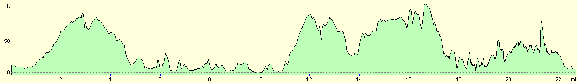
| Arabella | Invergordon | 8.2 | 249 | 262 |
| Invergordon | Alness Station | 4.2 | 151 | 66 |
| Alness Station | Dingwall campsite | 10.4 | 551 | 630 |
This makes a total distance of 22.8 miles, with 951 feet of ascent and 958 feet of descent.
For more information on profiles, ascents and descents, see this page
Accommodation
We spent the night at the Dingwall Camping and Caravanning Club Site, Jubilee Park, Dingwall, Highlands IV15 9QZ. This site was quite nice and was very well cared for, and it cost us Ł13.55 for the night. They can be contacted on (01349) 862236.
Disclaimer
Please note that I take no responsibility for anything that may happen when following these directions. If you intend to follow this route, then please use the relevant maps and check the route out before you go out. As always when walking, use common sense and you should be fine.
If you find any information on any of these routes that is inaccurate, or you wish to add anything, then please email me.
All images on this site are © of the author. Any reproduction, retransmissions, or republication of all or part of any document found on this site is expressly prohibited, unless the author has explicitly granted its prior written consent to so reproduce, retransmit, or republish the material. All other rights reserved.
Although this site includes links providing convenient direct access to other Internet sites, I do not endorse, approve, certify or make warranties or representations as to the accuracy of the information on these sites.
And finally, enjoy your walking!
This walk was mentioned in the following routes:
| My walk around the coastline of Britain |
Nearby walks
| # | Title | Walk length (miles) |
|---|---|---|
| 193 | Beauly to Garve | 16.4 |
| 536 | Meikle Ferry to Dornoch Ferry Inn | 27.6 |
| 537 | Dornoch Bridge Inn to Rockfield | 20.9 |
|
|

|