Walk #536: Meikle Ferry to Dornoch Ferry Inn
 |
 |
|
General Data
| Date Walked | 23/08/2003 |
| County | Highlands |
| Start Location | Meikle Ferry |
| End Location | Dornoch Bridge Inn |
| Start time | 07.18 |
| End time | 16.20 |
| Distance | 27.6 miles |
| Description | This was a long plod, the vast majority of it along roads that were fortunately quite quiet. |
| Pack | I used my new Highlands water hydration pack, which contained a two-litre water bottle, some spare batteries and a couple of chocolate bars. |
| Condition | I feel absolutely fine after this walk, and have no problems to report. Indeed, I could easily have walked further if it had been required. |
| Weather | Today was the first dry day for some time, with no sign of any rain. The high wind of yesterday had fortunately died down, and although there was plenty of cloud this was quite thin, and the sun broke through on many occasions. All in all it was not a bad day on which to do a long walk. |
| OS map | Landranger number 21 (Dornoch & Alness, Invergordon & Tain) |
 |
 |
|
 |
 |
|
Map of the walk
Maps courtesy of Google Maps. Route for indicative purposes only, and may have been plotted after the walk. Please let me have comments on what you think of this new format. For a detailed table of timings for this walk, please see the table file.
Notes
By the time that I woke up this morning the weather looked much improved, with more sunshine and far less wind. I felt fit and ready to tackle the day, so instead of having breakfast I decided to make myself a quick coffee and start the walk early. When Sam woke up I told her my plans, and we agreed to meet in a couple of hours for breakfast.
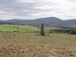
The initial part of the walk was past the Carnegie golf course and through the grounds of Skibo Castle, which I only got a short glimpse of through the trees. I then joined a track that passed the attractive Loch Opisdale before eventually reaching the A949 road. This road (indeed all the roads around Dornoch Firth) that I walked today used to be part of the A9(T) before the Dornoch Bridge was built, and hence they were well engineered and wide. They were also quiet, which allowed me to walk along without worrying overly about getting flattened by cars and lorries zooming along.
I met Sam for breakfast in Spinningdale, by the Old Mill Inn, which looks as if it has been shut for some time. Sam had some malt loaf and a coffee waiting for me, and I wolfed these down whilst we chatted. Spinningdale is named after the old cotton mill, the attractive ruins of which lie in the valley below the village. The mill was opened along with twenty houses in 1790, but it was destroyed by fire just eighteen years later, leaving ruins that are now quite attractive. I soon set off once again, for the long road plod along the northern side of the Firth of Dornoch. This was slightly spoilt by the fact that trees beside the road reduced the views over the Firth, but nonetheless I quite enjoyed the walk, and I soon fond myself entering Bonar Bridge.
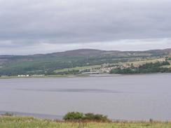
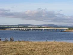
Bonar Bridge is dominated by the bridge over the Kyle of Dornoch that dominates the village. The modern bridge was opened on the 14th December 1973, and replaced another bridge on the 6th July 1893. This in turn replaced the original bridge, which had been destroyed by flood on the 29th January 1892. The modern bridge is a fairly boring steel arch, and the engravings of the previous two bridges on a memorial by the bridge seem to be much more interesting structures.
I met Sam for lunch in Ardgay, a mile away from Bonar Bridge on the southern side of the Kyle. She had bought me some ham salad sandwiches, so I wolfed these down, as by this time I was quite hungry. I had already walked nearly twelve miles, and I was well aware that I had another fifteen to do before I finished the day's walk, so some fuel was very necessary. The early start had paid off, and it was with some satisfaction that I realised that I had walked nearly twelve miles before midday.
The rest of the walk was along the southern shore of the Firth of Dornoch along the A836 road, excepting a little diversion I made along roads to Ardmore and back down to the A836 road at Edderton. This loop was quite nice, if only because it got me off the main road, which whilst quiet was fairly boring, and into more pastoral scenery.
I arrived at the caravan site much earlier than I had been expecting, as I made good time along the flat road from Ardgay. Sam had the evening meal prepared, so I relaxed for a few minutes whist she cooked the bangers and mash. The meal was superb and a veritable feast for the taste buds, and the gravy was delightful. Although the food satisfied my body my mind was still restless, so after we had let the food settle for a while we went for a little stroll to Ferry Point and back, a nice walk in the evening air. Unfortunately the views from the point were not as nice as I had been expecting, and although the Dornoch Bridge soared across the firth to the east, industrial buildings near to the jetty spoilt other views. Disappointed, we made our way back to the campsite, stopping off at the Inn for an hour or so to have a drink.
One of the reasons that I was so keen to get a long day done today is that I knew that I was taking tomorrow off, and so I would have a day to rest after the walk. The main reason that I am taking the day off is so that I can visit the Glenmorangie distillery, which I have been looking forward to for the entire walk. It is my favourite whisky, so it will be note to have a look around where it is made. The distillery is only a mile down the road, so it should be an easy stagger back.
Directions
This walk starts off at the jetty at Meikle Ferry. Head eastwards along the road for a couple of hundred yards, and just before a shed on the left turn left down a track that leads northwards to the clubhouse of the Carnegie golf course. At the clubhouse turn right along another track for a few hundred yards, and then turn left to head northwards along another track past Loch Evelix and Lake Louise towards Skibo Castle. Before the castle is reached turn left along another tracks that heads westwards along the southern shore of Loch Ospisdale, and a little way beyond the end of the lake turn left down another track that heads southwards towards the farm at Pulrossie.
Near the farm turn right to head westwards along another track for a little over a kilometre until it ends at a T-junction. At the junction turn right to head northwards along the road for about a kilometre until it ends at a T-junction with the A949 road. Turn left and follow the road westwards for about seven miles, as it passes through Spinningdale and eventually reaches the junction with the A836 road in Bonar Bridge. Turn left to cross the bridge over the Kyle of Sutherland, and then continue along the road southwestwards for a mile into Ardgay. Continue along the road as it crosses the railway line and passes the station into the village, and then turns to the left of head southeastwards along the southern shore of the Dornoch Firth through Kincardine.
Just beyond Dounie turn left down a road that heads northeastwards for about a kilometre, passing under the railway line before reaching Ardmore. Follow the road as it curves around to the right to head southwards, passing over the railway line before ending at a T-junction with the A836 road in Edderton. Turn left and follow the A836 road eastwards for a few miles until just before the roundabout with the A9(T) is reached, where a track leads off to the left past a campsite and the Dornoch Bridge Inn. Continue along this road for a mile and a half as it heads northwestwards to Ferry Point, and then turn around and head back southeastwards to the Dornoch Bridge Inn, where this walk ends.
Distances
| From | To | Distance (m) | Ascent (ft) | Descent (ft) |
|---|---|---|---|---|
| Meikle Ferry | Spinningdale | 5.7 | 410 | 358 |
| Spinningdale | Bonar Bridge | 5.2 | 479 | 531 |
| Bonar Bridge | Dornoch Bridge Inn | 13.7 | 886 | 879 |
| Dornoch Bridge Inn | Dornoch Bridge Inn (via Ferry Point) | 3.0 | 40 | 40 |
This makes a total distance of 27.6 miles, with 1815 feet of ascent and 1808 feet of descent.
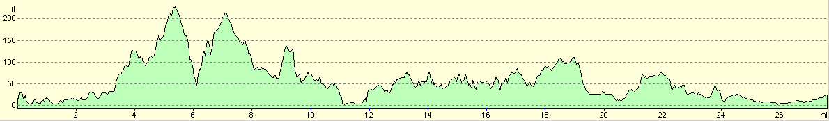
For more information on profiles, ascents and descents, see this page
Accommodation
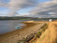
We spent two nights at the Dornoch Fiirth Caravan Park, Meikle Ferry South, Ross-shire, Highlands IV19 1JX. This site was very nice, with a pub adjacent to it. Everything was very clean and tidy, and I could not really fault the site. They can be contacted on (01862) 892292, or by email at will@dornochfirth.co.uk, and they have a web presence at www.dornochfirth.co.uk.
Disclaimer
Please note that I take no responsibility for anything that may happen when following these directions. If you intend to follow this route, then please use the relevant maps and check the route out before you go out. As always when walking, use common sense and you should be fine.
If you find any information on any of these routes that is inaccurate, or you wish to add anything, then please email me.
All images on this site are © of the author. Any reproduction, retransmissions, or republication of all or part of any document found on this site is expressly prohibited, unless the author has explicitly granted its prior written consent to so reproduce, retransmit, or republish the material. All other rights reserved.
Although this site includes links providing convenient direct access to other Internet sites, I do not endorse, approve, certify or make warranties or representations as to the accuracy of the information on these sites.
And finally, enjoy your walking!
This walk was mentioned in the following routes:
| My walk around the coastline of Britain |
Nearby walks
| # | Title | Walk length (miles) |
|---|---|---|
| 535 | Littleferry to Meikle Ferry | 21.1 |
| 537 | Dornoch Bridge Inn to Rockfield | 20.9 |
|
|

|