Walk #540: Dingwall to Cromarty
 |
 |
|
General Data
| Date Walked | 28/08/2003 |
| County | Highlands |
| Start Location | Dingwall |
| End Location | Cromarty |
| Start time | 09.35 |
| End time | 18.21 |
| Distance | 24.0 miles |
| Description | This was a long and fairly boring plod along roads across the northern side of the Firth of Cromarty. |
| Pack | Today I carried my 30-litre Karrimor HotRock rucksack, which was filled with my packed lunch, waterproof leggings, water bottle and a couple of spare shirts, together with the usual assortment of odds and ends. |
| Condition | I am more or less okay after this long walk, and the only significant problem that I have had is with my right foot, which gave me a little gip for the last six or so miles. My neck and right shoulder are fine, which is quite welcome. |
| Weather | Today was very much a day of sunshine and showers; the latter were at times quite heavy, and the sunny periods were strong enough to dry me off fairly quickly. A gusting wind accompanied the showers and this cooled me down, yet when the sun was shining I was too warm with my coat on! |
| OS map | Landranger number 26 (Inverness & Loch Ness) and Landranger number 21 (Dornoch & Alness, Invergordon & Tain) |
 |
 |
|
 |
Map of the walk
Maps courtesy of Google Maps. Route for indicative purposes only, and may have been plotted after the walk. Please let me have comments on what you think of this new format. For a detailed table of timings for this walk, please see the table file.
Notes
I woke up this morning full of energy and looking forward to a lovely day's walk. As we had mains power I did a few hours work on the computer, writing up the last three day's photographs and doing a little script work. For some strange reason I really missed computers over the last few days (not a feeling that I have had very often on this walk), and so I used the opportunity to do a little programming. I have often wondered how many photographs I have taken on this trip (certainly in the thousands), and the scripts now tell me this.
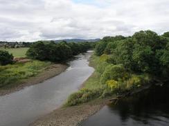
Te first part of the walk was along the remains of the Dingwall Canal, the most northerly canal in the country. This was a nice tree-lined walk that crossed a firing range (fortunately the red flag were not flying this morning and so I could walk along the path). The water levels in the canal were quite low, and this exposed some smelly mudflats that were complete with all the usual town detritus - trolleys, baskets and other assorted metal and woodwork slowly rotting away. The path then met the side of the firth, and this made for a slightly more attractive walk.
Unfortunately the majority of the walk along the eastern side of the firth was far less attractive, as the road climbed high up on to the hillside and views were obscured by trees. I had planned to divert down to Toberchurn and walk to Craigton along a track marked on the map, but the showers were getting more frequent and I did not really want to have to walk through wet grass in my trainers, which were already getting damp. Instead I stuck to the road, and concentrated on taking my mind off the boring plod. I decided to eat my sandwiches as I walked, and so I got them out and hung them from my pack and started munching. As soon as I did this Sam drove past, and I ended up sitting in Mervan whilst I ate.
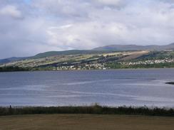
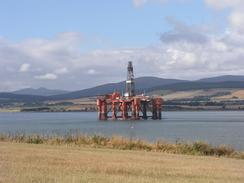
Once I reached Newhall Point in Balblair the walk got more interesting as better views slowly unfolded. There was an oilrig and a couple of large tugs very close by, and I got some good photos of these before I moved on. The rest of the walk to Cromarty was far more picturesque, and the views over the firth were far better. Of particular interest to me were the nine oilrigs that could be seen moored in a row in the firth, which made for a magnificent sight. These massive structures fascinate me, but in a strange way they seem quite small when viewed against the firth. As I neared Cromarty the hardest shower of al came ore and thoroughly soaked me, and unfortunately there was not enough sun afterwards to dry me off before I reached Mervan, so I looked like a drenched rat when I finally arrived.
Cromarty is quite a nice little town, and I enjoyed my walk around it to the lighthouse and down the other side to the car park where Sam was waiting for me. Yet again she had picked a great place to park - we had some lovely views over the Firth, and as the sun went down I watched ships going to and fro past the mouth of the firth. Navigation beacons were blinking red lights, and the whole view out of the window was superb. This morning I could see past the headland of the Ross of Cromarty and see transmission masts near RAF Lossiemouth on the Grampian coast, a long way away.
This evening I was reading teletext when I found out that Stephen Gough, the 'naked rambler', who is doing a Land's End to John O'Groats walk naked, has been arrested once again and appeared in Dingwall Sheriff Court today after being arrested 11 times. I find it quite amazing that we should be in the same town at the same time, but I honestly cannot see why he is doing what he is doing, and it all reeks of self-publicity in my opinion. He has been on television and in the press so many times over the last few weeks, but what he is doing seems absolutely pointless - he certainly will not end up changing the law on nudity, and perhaps that is a good job too.
Directions
This walk starts off at he campsite in Dingwall, just off Jubilee Park Road. Leave the campsite and once you are out of the gate turn to the left and climb up onto the bank on the southern side of the Dingwall Canal. Turn to the right and walk along the canal towards the firth. Just after a footbridge over the canal on the left turn right down a road that heads south along a little flood bank that heads southwestwards beside the firth. When this joins a track on the right turn right and follow the track northwestwards, crossing a railway line on a level crossing and then reaching an underpass under the A862 road. Climb up onto the top of the A862 road, and turn left to head southwestwards along the road (which has wide pavements on either side) until a roundabout with the A835(T) is reached.
At the roundabout turn left to head southeastwards along the A835(T) for about a mile, as it crosses over the railway line and the river Cromarty. The road climbs up a slight hill, and the turn left along the B9163 road. Follow this road as it heads northeastwards along the southern shore of the Cromarty Firth for over four miles until the A9(T) is reached Cross over the A9(T) and continue on along the B9163 as it starts to climb uphill. After a couple of miles a junction is met with the B9169 road; continue on northeastwards along the B9163 road along the crest of a hill. The road passes Resolis and continues on towards Kirkton. Immediately after the B9163 road curves to the right turn left downhill along a road that passes through Balblair and reaches the shore, which it follows eastwards to Newhall Point.
At Newhall Point turn right and follow the road as it heads southwards along the western shore of Udale Bay. After about a kilometre it passes the remains of the Kirkmichael Church and rejoins the B9163 road. Turn left to walk south along the B9163 road as it passes over Newhall Burn, and a short distance later follow the B9163 as it turns to the left. Follow the B9163 as it heads eastwards through Jemimavaille and skirts the southern side of Cromarty Bay until it enters Cromarty. Follow the road around past the harbour and towards the lighthouse, and then walk down the eastern side of the village to the car park in Shore Street, where this walk ends.
Distances
| From | To | Distance (m) | Ascent (ft) | Descent (ft) |
|---|---|---|---|---|
| Dingwall | Balblair | 16.4 | 692 | 623 |
| Balblair | Cromarty | 7.6 | 292 | 364 |
This makes a total distance of 24.0 miles, with 984 feet of ascent and 987 feet of descent.
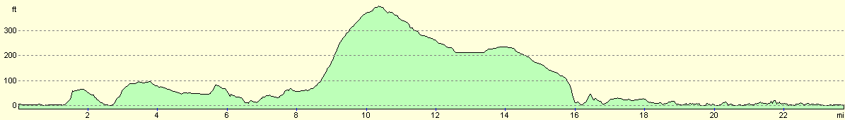
For more information on profiles, ascents and descents, see this page
Accommodation
We spent the night parked on Shore Street in Cromarty, which had some lovely views over the Firth of Cromarty and over to Nigg Ferry. There was a pub nearby, but we did not need to use it.
Disclaimer
Please note that I take no responsibility for anything that may happen when following these directions. If you intend to follow this route, then please use the relevant maps and check the route out before you go out. As always when walking, use common sense and you should be fine.
If you find any information on any of these routes that is inaccurate, or you wish to add anything, then please email me.
All images on this site are © of the author. Any reproduction, retransmissions, or republication of all or part of any document found on this site is expressly prohibited, unless the author has explicitly granted its prior written consent to so reproduce, retransmit, or republish the material. All other rights reserved.
Although this site includes links providing convenient direct access to other Internet sites, I do not endorse, approve, certify or make warranties or representations as to the accuracy of the information on these sites.
And finally, enjoy your walking!
This walk was mentioned in the following routes:
| My walk around the coastline of Britain |
Nearby walks
| # | Title | Walk length (miles) |
|---|---|---|
| 192 | Lewiston to Beauly | 14.7 |
| 193 | Beauly to Garve | 16.4 |
| 538 | Rockfield to Arabella | 19.3 |
|
|

|