Walk #432: Askam in Furness to Haverigg
 |
 |
|
General Data
| Date Walked | 03/05/2003 |
| County | Cumbria |
| Start Location | Askam in Furness |
| End Location | Haverigg |
| Start time | 08.10 |
| End time | 15.25 |
| Distance | 19.6 miles |
| Description | This was a most enjoyable walk, with some lovely views available across the Duddon Estuary, and north into the Lake District. |
| Pack | Today I carried my 30-litre Karrimor HotRock rucksack, which was filled with my packed lunch, waterproof leggings, water bottle and a couple of spare shirts, together with the usual assortment of odds and ends. |
| Condition | The biggest problem after today's walk is the condition of my feet, which ached severely at the end of the walk. This was due to filling my boots with dirty water early on in the walk, and the resultant squelching noise annoyed me more than the wet feeling, at least early on. Both of my ankles were fine, and gave me no troubles. |
| Weather | The morning dawned sunny with only a few clouds scattered about in the blue sky. As the morning went on the clouds started to gather and the blue sky disappeared. About an hour before I finished it started to spit with rain, and this got heavier until I reached Mervan, when the wind strengthened and the heavens finally opened. |
| OS map | Landranger number 96 (Barrow-in-Furness & South Lakeland) |
 |
 |
|
 |
 |
|
Map of the walk
Maps courtesy of Google Maps. Route for indicative purposes only, and may have been plotted after the walk. Please let me have comments on what you think of this new format. For a detailed table of timings for this walk, please see the table file.
 |
 |
|
Notes
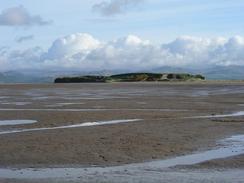
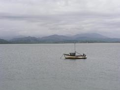
The weather forecast was for it to rain in the afternoon, so I decided that a slightly earlier start than usual would allow me to make the best advantage of the early sunny weather. I did not sleep very well last night, and so it took me a mile or so to get into my stride. The tide was quite low, and I could see Millom clearly on the opposite side of the Duddon estuary. It looked very tempting to stride across the sands, but I was loath to risk doing this, as I was unsure of any safe routes across. Some are marked on the Ordnance Survey maps, but river channels in estuaries change so regularly that I would not trust a route marked on maps without local knowledge to guide me.
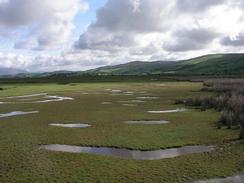
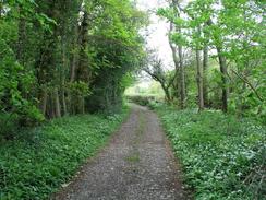
Early on the route up towards Kirkby in Furness Station follows the railway line across an area of marshland. I was tempted to avoid the marshland altogether and to walk along the fringe between the sands and the marshes, but I did not want to risk getting caught out (a minor risk, it must be said). Unfortunately I joined the railway line too soon, and the path that I was following soon became flooded with water that had run off the railway embankment and had not flown away. I got through the first of these easily, with the water coming up to the top of my boots but not getting in, but the second one was far deeper, and my boots plunged in until the water was halfway to my knees. Water plunged into my boots, and the foul smell of marshland came to my nostrils, a thick pungent smell that I have always disliked. I soon came to another stretch of water, but this time I climbed over the railway fence and diverted past it by walking along the bottom of the embankment. When I finally got to the station I sat down on the footbridge so that I could, empty my boots out, which had been squelching away merrily. Unfortunately no water came out - it had been absorbed by my socks, boots and footbed, so I just had to cope with the squelching sound for a few hours.
I met Sam at the High Cross Inn, which is just to the west of Broughton in Furness, at a few minutes past eleven. We walked into the interior to be faced with a couple of people at the bar who looked rather the worse for wear. It turns out that they had a lock-in last night, and someone even ended up sleeping on the pool table! This made me quite nostalgic about some of the things that I used to do when I was younger, and I became even more nostalgic when the landlord and I started talking about pubs in the Peak District!
The walk from High Cross In down to Millom and Haverigg was fairly easy and nondescript, and I walked on autopilot for much of the way. On the way north along the other side of the river I had a vista of the Lake District Mountains ahead of me, but on the western side the views were behind me which I found slightly depressing. I did not enter Millom, but I walked around the outside of a large lake past Hodbarrow Point, which was a surprisingly nice little walk.
towards the end of the walk Tom Isaac phone up, and we spent ten minutes chatting about the walk. It was a strange conversation as I was simultaneously filled with happiness for his achievement in finishing the walk, depression at how far I still have to go, jealousy for his having completed it, and joy at the scenery to come. These feelings probably seem strange to anyone who has not done this walk, but to me they are understandable - mentally I can only concentrate on one day at a time, and to talk to someone who has done it all is overwhelming. Tom is currently writing thank you out letters to everyone who has supported him, and raising more money for the Parkinson's disease Society. I am totally amazed by his achievement, and he has stated that he want to meet me at the end of my walk - something that I will only be to glad to see happen. He has been reading my website, and is apparently amazed by the detail of my notes. I'm not sure whether this makes me a nutter or an obsessive...
Tonight we drove to the High Cross Inn, where we met June Chapman, the local organiser for the Riding for the Disabled Association. We spent the night at her lovely house, and we were up chatting until well after eleven, our latest night for a while. I also got the opportunity to have a bath, something that takes me to heaven, and allowed me to soak my aching limbs. It feels very strange to spend the evening in a house instead of in Mervan, and it feels exceedingly strange to be in a bed that has drops on all sides instead of walls. It is quite remarkable how life in a campervan has become 'normal' to us, and how living in a house feels alien.
Directions
For most of this walk I followed the Cumbrian Coastal Way, except for a couple of little diversions where the Way was not the nearest right of way to the Duddon River Estuary; my diversions however involved road walks, so you may prefer to do the Way proper.
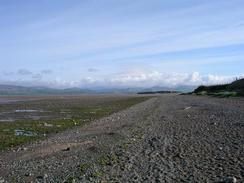
This walk starts off at a car park beside the beach to the northwest of the village of Askam in Furness. As the tide was out I descended down to the beach and walked northwards along the wide expanse of sand, aiming for the western tip of the little headland of Dunnerholme. Once past the headland I turned to the right and followed the edge of the headland eastwards toward the edge of some marshland and a golf course. Follow the marshland past the golf course before it turns to a more northerly course, paralleling the railway line before eventually running immediately by the railway line until it approaches Kirkby-in-Furness railway station.
Cross the railway line using the station footbridge to get to the road on the eastern side of the line. Turn left and follow this road northeastwards for about a kilometre until the road turns sharply to the right to head towards the A595. At this bend continue straight on along a footpath that heads northwards for a few hundred metres before ending at a road. Turn left at this road and follow it northwestwards, before it turns to the right and the left to head past Waitham Hill and Waitham Common. At Angerton Moss the road curves to the left to reach a level crossing over the railway line, after which the road curves to the right to parallel the line northwestwards before ending at the A595(T) road. Turn left down the A595(T) road and follow it past Foxfield Station and onwards. There is a cycle path until the road curves to the left; after this you have to walk along the road as it curves to the right and heads uphill to reach High Cross Inn.
From the High Cross Inn turn left to head downhill along the main road. At the bottom of the hill a footpath leads off to the left, crossing the River Lickle before hading westwards to meet the eastern bank of the River Duddon. It then turns to the right to head northwestwards to meet the main road once more. Turn left and cross the river on Duddon Bridge, and then continue along the road or about a kilometre before taking a road that leads off to the left, heading south pat Low Bog House until Lady hall is reached. Here a footpath leads off to the left and heads southeastwards, crossing a railway line and joining a flood bank that it follows past Long Shaw, where it joins a track that crosses a stream and reaches a track near Green Road Station.
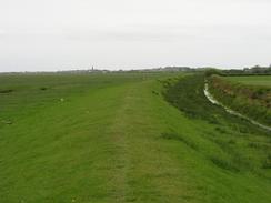
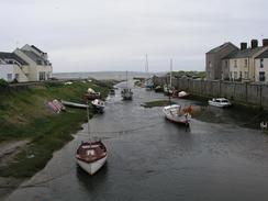
Turn left down a track until a flood bank is reached by the river; turn right and walk southwestwards along the flood bank, passing Underhill Cottages before turning inland to cross Salthouse Pool near Millom. Cross the stream and on the other bank turn left along an old railway line that heads past the site of an old ironworks. Just past the youth hostel turn to the right to had down a track until a road is reached, where you can turn to the left to walk down a footpath that leads back to the estuary. Once there turn right and follow the flood bank past Crab Marsh before it climbs up to the trig point on Hodbarrow Point. Descend from the point and follow a track around the Outer Barrier passing the lake and an old lighthouse until it ends by a marina. Turn left to walk into Haverigg; cross over Haverigg Pool in the village and this walk ends at a car park by the lifeboat station in the village.
For more details of the Cumbria Coastal Way, see the excellent little book, The Cumbria Coastal Way: A Walker's Guide", by Ian and Krysia Brodie, ISBN 187355110X. This book is a lovely and detailed description of the walk, and unfortunately I did not manage to get a copy until after I fnished the walk, for it would have been quite handy.
Distances
| From | To | Distance (m) | Ascent (ft) | Descent (ft) |
|---|---|---|---|---|
| Askam in Furness | High Cross Inn | 8.2 | 407 | 302 |
| High Cross Inn | Haverigg | 11.4 | 443 | 577 |
This makes a total distance of 19.6 miles, with 850 feet of ascent and 879 feet of descent.
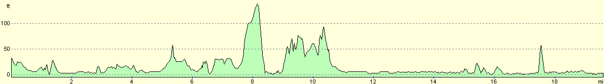
For more information on profiles, ascents and descents, see this page
Accommodation
We spent the night at the house of a supporter and RDA member, June Chapman, near the High Cross Inn. This was an incredibly kind deed of her and was much appreciated, particularly as it meant that I could have a bath! We stayed up very late chatting, and going to bed in a normal bed and not in Mervan was most certainly a novelty!
Disclaimer
Please note that I take no responsibility for anything that may happen when following these directions. If you intend to follow this route, then please use the relevant maps and check the route out before you go out. As always when walking, use common sense and you should be fine.
If you find any information on any of these routes that is inaccurate, or you wish to add anything, then please email me.
All images on this site are © of the author. Any reproduction, retransmissions, or republication of all or part of any document found on this site is expressly prohibited, unless the author has explicitly granted its prior written consent to so reproduce, retransmit, or republish the material. All other rights reserved.
Although this site includes links providing convenient direct access to other Internet sites, I do not endorse, approve, certify or make warranties or representations as to the accuracy of the information on these sites.
And finally, enjoy your walking!
This walk was mentioned in the following routes:
| My walk around the coastline of Britain |
Nearby walks
| # | Title | Walk length (miles) |
|---|---|---|
| 429 | Grange-over-Sands to Ulverston Sands | 22.8 |
| 430 | Ulverston Sands to Robin Whins Point | 18.0 |
| 431 | Robin Whins Point to Askam in Furness | 17.9 |
|
|

|