Walk #830: Chichester to Southbourne
 |
 |
|
General Data
| Date Walked | 19/02/2009 |
| County | West Sussex |
| Start Location | Chichester |
| End Location | Southbourne (West Sussex) |
| Start time | 08.18 |
| End time | 16.35 |
| Distance | 21.9 miles |
| Description | This was a pleasant walk, initially following the Chichester Canal before heading off along the coast. |
| Pack | Today I carried my 30-litre Karrimor rucksack, filled with waterproofs, a book and other odds and ends. |
| Condition | I suffered a surprising amount in this walk. For the first time in ages I got blisters on the backs of my heels, and my little toes also suffered with blisters. When I got home, I found out that I was wearing a pair of Sencan's walking socks! |
| Weather | Today was mostly overcast, with frequent drizzle showers and only occasional glimpses of the sun. It was not a cold day. |
| OS map | Landranger number 197 (Chichester & The South Downs, Bognor Regis & Arundel) |
 |
 |
|
 |
 |
|
Map of the walk
Maps courtesy of Google Maps. Route for indicative purposes only, and may have been plotted after the walk. Please let me have comments on what you think of this new format. For a detailed table of timings for this walk, please see the table file.
 |
 |
|
 |
 |
|
Notes
In the middle of last year, I re-walked part of the coast to the east of Portsmouth as part of my walk along the Wayfarers Walk. At the time I had plans to continue on eastwards, with a 30-mile walk from Bognor. Unfortunately, a twisted ankle got in the way, and meant that my walking for the rest of the year was severely curtailed. Therefore I decided to do a shortened version of the walk today, starting off in Chichester.
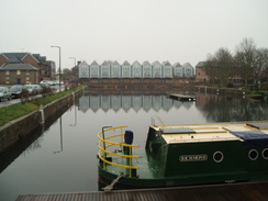
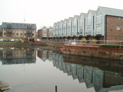
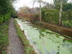
By the time I parked at Chichester station I was desperately in need of the toilet, but there was nowhere to go - the toilets at the station are beyond the barriers, and the Waitrose was not due to open for half an hour. Instead I threw my gear on and set off. The initial part of the walk follows the Chichester Canal, part of the Chichester and Arundel canal, and originally part of the long canal from London to Portsmouth. This stretch opened in 1822, only a few years before the first railways reached the area. The canal basin was attractive, with neat buildings overlooking it. Unlike many canal basin restorations this had not been spoilt by hundreds of newly-built flats overlooking it, and I enjoyed my walk around one side of it.
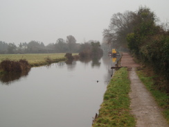
The stretch of the canal down to Hunston is still navigable, and I made good time along this stretch. It was still early in the morning and a couple of joggers passed me, along with people walking into work, one of whom was in a suit and carried a briefcase. As commutes into work goes, it is hardly a bad one. There were plenty of information boards scattered about giving information about the canal, and the towpath underfoot was firm and allowed a fast pace.
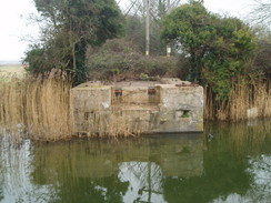
At Hunston the canal towpath crosses a bridge and joins the main road for a short distance; however this stretch of towpath was closed for renovation. I therefore diverted along roads, stopping off at a shop to by some provisions, before walking through local roads to rejoin the towpath opposite a strange concrete block. At first I though that this was some strange form of World War Two pillbox, but a nearby noticeboard told me that this was the base of a lifting bridge that had carried the Selsey Tramway over the canal.
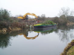
A little further on was Crosbie Bridge, one of two remaining blockages of the canal. It was drizzling slightly as I headed on to the next blockage at Cutfield Bridge, where the busier A286 crosses the line of the canal. There are plans for both of these bridges to be replaced to allow canal traffic to travel from the sea to Chichester, and although the task appears big, it is nowhere near the biggest civil engineering job done recently on canals.
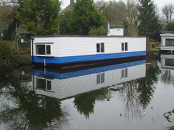
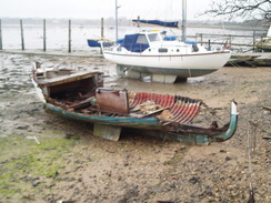
Initially the next stretch of canal was weed-filled, but shortly afterwards it became clearer. The course of the towpath has been obliterated by an access road to a marina, but this was quiet and easy to walk along. Eventually houseboats started appearing, and then I entered the marina. Many boats were stored up on dry land, held up in the air by seemingly flimsy and insubstantial pieces of timber. A couple of boats were on low loaders, ready to be taken elsewhere, and then I reached the sea at the surprisingly deep Salterns Lock.
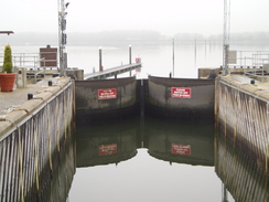
Here I joined the coast, and for the rest of the day I followed the route that I had followed on my previous walk. Adjacent to Salterns Lock was the Chichester Yacht Harbour, where what looked like hundreds of yachts were moored. The entrance to the lock is guarded by large, clamshell-like lock gates, along with a complex traffic-light system that resembles a Christmas tree. A stroll along tracks and roads took me past the first swarm of insects of the year to Dell Quay. Five hundred years ago this quiet and picturesque spot was apparently the seventh most important port in England, and even up to the early 1800s over a hundred ships were registered. Now, it is just a sleepy backwater.
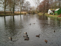
Paths along floodbanks took me north into Chichester; after a while the path left the banking and became much muddier. It was a relief when I reached the outskirts of Fishbourne, where a stream was followed towards the mill pond. There was a bench here, so I stopped and watched as a mother and her three children fed the scrabbling ducks. As I ate my sandwiches I occasionally threw the birds a few meagre crumbs as well.
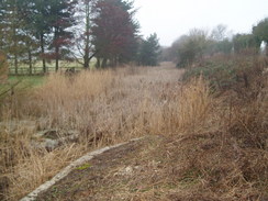
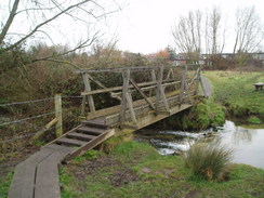
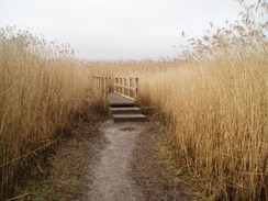
The next stretch of path took me through an area of reeds, although the path underfoot was relatively firm, with a couple of new-looking wooden bridges to take me over tidal streams. After this the path followed floodbanks and the foreshore southwards towards Bosham Hoe; it was a fairly boring stroll and I successfully managed to put my mind in neutral. Soon the path headed inland, joining roads that took me down towards Bosham Hoe. Here there were road works for a new drainage system; this was the only point of interest as the roads headed westwards along the bottom of the peninsular.
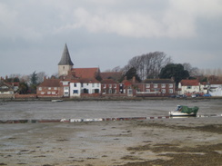
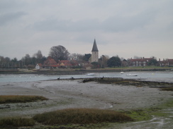
Eventually a path took me down the short distance towards the foreshore, where a seasonal ferry plies across to West Itchenor on the other side of the Chichester Channel. This was a pleasant spot, and I enjoyed the next stretch of walk along the foreshore northwards. On the way up to Bosham I was surprised to see a neat, low wooden container on the bank, with a sign stating that it was for shoreline rubbish. It was visible yet also unobtrusive, and seemed like an absolutely brilliant idea. Eventually a tidal road was reached, and this took me on northwards into the village. The red-tile roof and spire of the church and be seen across the mudflats, and mad for a good target, albeit one that took some time to reach as the road winds around the foreshore.
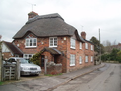
I had pleasant memories of Bosham from my coastal walk; I remembered a man feeding swans there, and a pleasant trip to the Anchor Bleu pub. The sans were still there, although no-one was feeding them, and I stopped off at the pub for a drink. It was as friendly as it had been before, and I sat outside as I listened to the radio.
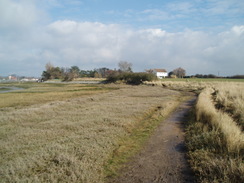
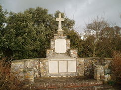
After leaving the pub I diverted off to look at the pretty war memorial in the village, before heading off along footpaths, foreshore and floodbanks to reach the A259 road at the top of the Colner Creek. There was a wide cycle path to follow along this road, and after this I headed down along floodbanks towards Chidham. From here a good, well-surfaced path led me down past the little boatyard at Cobnor House to Cobnor point.
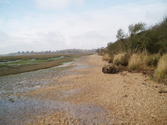
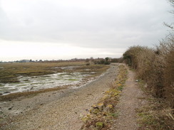
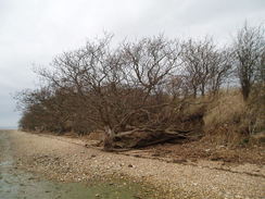
Here the path was left behind, and a walk along the foreshore and floodbanks took me northwards for the final time in the day, towards Chidham Point and beyond. It was another fairly ordinary stretch of walk, the best part being the early stretches along the foreshore, where tree roots lie exposed out of the banking. Eventually I reached the point where a path leads north and eastwards towards Nutbourne, but I decided to walk on, aiming for the stations in either Southbourne or Emsworth. The sun was sinking low, so at Prinsted I left the coast with regret and headed along roads through this attractive village towards Southbourne station. It had been a very pleasant day's walk despite the rather dismal weather. It is hardly classic coastal walking, but is well worth visiting nonetheless.
 |
 |
|
 |
 |
|
Directions
This walk starts off at Chichester railway station. Leave the station and cross the level crossing. Head osuth along the A286 for about fifty yards, then turn left down a road to reach a canal basin. Walk along the head of the basin, then join the towpath that runs along its southern edge, This then curves to head southwards for a little over a mile until it reaches Poyntz Bridge to the north of Hunsron. Here cross the bridge, and ont he other side join the B2145 road.
Turn right and walk along the B2145 towards Hunston for a short distance, then turn right to join the towpath once more, this time on the southern side of the canal. Follow this westwards for one and a half miles to the site of Cutfield Bridge on the A286 (now a culvert), crossing Crosbie Bridge on the way. At Cutfield Bridge the towpath follows the northern side of the canal, follow an access drive to the Chichester Yacht Harbour. Follow this westwards for a mile, keeping the canal on the left, as it passes through the marina and reaches saltern Lock, at the very western edge of the canal.
Turn back and head back towards the Chichester Yacht Harbour. After about a hundred yards turn to the left through a boatyard along a track that leads to the lock gates into the harbour.
Cross the lock gates an take a footpath that continues northeastwards on the other side. The footpath enters a patch of woodland before emerging and crossing a field and reaching a surfaced track by New Barn. Turn left up this track and follow it for a kilometre until it ends at Dell Quay Road. Turn left down this road and follow it until it reaches Dell Quay. Walk past the pub to the river bank and then turn to the right along a footpath that runs right beside the channel. After a while the footpath leaves the floodbank and crosses a field before rejoining the flood bank. It heads north for a little over a mile until it crosses a stream by a bridge on the southern edge of Fishbourne.
When the footpath crosses another stream by another bridge turn left along another footpath that heads westwards beside a stream for a short distance until it emerges at a road beside the Mill Pond. The path continues on the other side and runs through an area of low-lying and boggy land with reeds everywhere; there are several footbridges over streams. The path leaves this area and climbs up onto the flood bank and heads south for a little over a kilometre. When the footpath approaches a little creek it turns to the right and heads inland to the west for a few hundred yards until it meets another footpath. Turn left along this footpath as it heads southwards until it meets a bend in a surfaced track near Hook Farm.
Turn right to head westwards along the track for a little under a kilometre until it meets a road by Church Farm. Turn left along this road and follow it westwards until it reaches a T-junction with another road near Chasebury Farm. Turn left down this road and follow it southwards past Hoe Farm towards Bosham Hoe. Follow the road as it curves around to the right and heads westwards for a little over a kilometre. When the road turns sharply to the right to head northwards take a track that leads off to the left to head southward for a short distance to the river, at an old ferry landing place. At the river turn right along a footpath that follows the edge of the river along Bosham Channel over ground that is sometimes boggy as it is below the high tide line.
Eventually the path meets the road once more. This road also floods at high tide, although in places there is a footpath at a higher level that will allow progress when the road is flooded. The road curves past Southwood Farm along the southern edge of a channel before curving around the end of the creek and entering Bosham. Follow the road around until it ends and make your way the short distance through the village towards the church. Before the church is reached turn right along a road that heads northwards past a chapel. When the road curves to the right continue straight on along a road and then after a few yards turn left down a footpath that leads westwards to the riverbank. The footpath then turns to the right to head northwards alongside the river until it meets the A259 road.
Turn left and walk westwards along the A259 road for a little under a kilometre. Immediately past a house on the left turn left down a footpath that skirts the eastern edge of a creek for a kilometre until it curves to the right and ends at a road to the north of Chidham. Walk south along the road towards the southern end of the creek, then turn left down a private road. When this ends at the western bank of the Bosham Channel, continues on along a footpath along southwards. The path makes a diversion inland around a little boatyard to the east of Cobnor House and rejoins the bank on the southern side of the yard. From here a good surfaced path continues on southwards to Cobnor Point.
At Cobnor Point the surfaced path continues on northwestwards for a short distance until it ends and the footpath drops down to the side of the channel. The path then continues on northwards, alternating between running along the top of the bank and at the base of it, which could make the path difficult to navigate on very high tides. In places the bank is very eroded, which may also make progress difficult. The path passes Chidham Point and eventually turns to the left to head westwards for a little under a mile along the top of the bank to the south of Nutbourne and Prinstead.
When the path meets the end of a road in Prinstead, turn right to head northwards through the village. When the road forks, take the right-hand fork and follow it northwards until it reaches the A259 road. Turn right along the A259 road for a couple of hundred yards; just after a church on the left, turn left to walk notrh along a road to Soutnbourne station, where this walk ends.
 |
 |
|
 |
 |
|
Distances
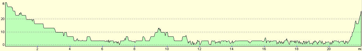
| From | To | Distance (m) | Ascent (ft) | Descent (ft) |
|---|---|---|---|---|
| Chichester station | Salterns Lock | 4.3 | 10 | 39 |
| Salterns Lock | Fishbourne | 3.2 | 26 | 23 |
| Fishbourne | Bosham | 5.9 | 49 | 52 |
| Bosham | Southbourne station | 8.5 | 112 | 89 |
This makes a total distance of 21.9 miles, with 197 feet of ascent and 203 feet of descent.
For more information on profiles, ascents and descents, see this page
Transport
There are regular train services running directly between Southbourne and Chichester.
 |
 |
|
 |
Disclaimer
Please note that I take no responsibility for anything that may happen when following these directions. If you intend to follow this route, then please use the relevant maps and check the route out before you go out. As always when walking, use common sense and you should be fine.
If you find any information on any of these routes that is inaccurate, or you wish to add anything, then please email me.
All images on this site are © of the author. Any reproduction, retransmissions, or republication of all or part of any document found on this site is expressly prohibited, unless the author has explicitly granted its prior written consent to so reproduce, retransmit, or republish the material. All other rights reserved.
Although this site includes links providing convenient direct access to other Internet sites, I do not endorse, approve, certify or make warranties or representations as to the accuracy of the information on these sites.
And finally, enjoy your walking!
Nearby walks
| # | Title | Walk length (miles) |
|---|---|---|
| 300 | Worthing to Pagham | 18.7 |
| 301 | Pagham to West Itchenor | 19.4 |
| 302 | West Itchenor to Chidham | 14.9 |
|
|

|