Walk #834: A circular walk from Lymington to Sway
 |
 |
|
General Data
| Date Walked | 09/03/2009 | ||||
| County | Hampshire | ||||
| Start Location | Lymington | ||||
| End Location | Lymington | ||||
| Start time | 08.41 | ||||
| End time | 16.31 | ||||
| Distance | 19.6 miles | ||||
| Description | This was a pleasant walk, following the Solent Way towards Milford on Sea, then circles around north via Sway. | ||||
| Pack | For the first time this year I carried my large Macpac rucksack, carrying partial camping kit weighing 15 kg. | ||||
| Condition | I feel reasonable after this walk; my feet were aching a little at the end, but soon recovered. | Weather | The day started off sunny, but with a fierce breeze that was very noticeable on coast. AS the morning drew on the clouds started to gather, and there were a couple of brief periods of light drizzle. | OS map | Landranger number 196 (The Solent & The Isle of Wight, Southampton & Portsmouth) and Landranger number 195 (Bournemouth & Purbeck, Wimborne Minster & Ringwood) | |
 |
 |
|
 |
 |
|
Map of the walk
Maps courtesy of Google Maps. Route for indicative purposes only, and may have been plotted after the walk. Please let me have comments on what you think of this new format. For a detailed table of timings for this walk, please see the table file.
 |
 |
|
 |
 |
|
Notes
The forecast was for a pleasant, sunny day with only occasional showers, so it felt like a good opportunity to walk the stretch of coast at the western end of the Solent Way. It did not take me long to drive down to Lymington, and I parked at the car park in the centre of the town - it costs five pounds for the entire day. I think that there may be cheaper car parks further out, but this one suited my purposes. Initially I walked through the town without my kit, aiming for the public toilets, then headed back and got some grub for the day from the Tescos in the centre of the town.
Only then did I set off on the walk proper. For the first time in well over a year, I was carrying my large backpacking rucksack, the start of my training for long-distance walks I hope to start doing soon. This had only partial kit in, and the pack only weighted about thirty pounds. This seemed like a good way to start my training. The last time that I used this pack was when I travelled back from Dublin after my sailing trip, and so all the straps had been tightened to stop problems on the airport conveyor belts. I had readjusted them, but they were to cause problems for the rest of the day.
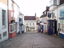
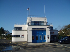
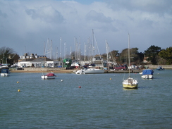
I diverted off route for a few hundred yards to visit the roundabout that I headed past on the last walk in this area; then I headed back and descended down a lovely cobbled street, filled with attractive old houses and shops. It was a very nice area of the town, and led to the little quayside. Boat trips were advertised out to the Isle of Wight; a tempting proposition, but I chose to walk on. As I passed the grand bandstand a large ferry came in from the Isle of Wight. The neat lifeboat station is right by another car park that I could have started the walk at, and I then squeezed past the Lymington seawater pool (looking remarkably enticing in the sunshine) and a marina.
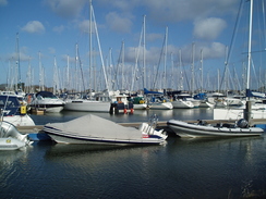
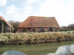
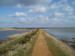
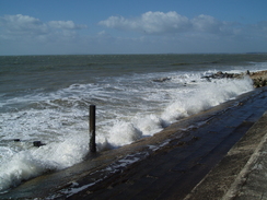
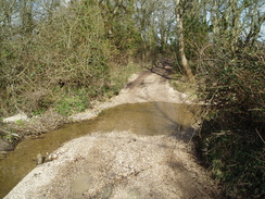
The path passed through the marina, before curving past lots of expensive-looking boats that had been hauled up onto the ground. Only after this did I at last get onto the seawall proper. The path really winds around; you walk a long way to end up just a short distance away from where you started. Still, it was pleasant in the sunshine, but the breeze was extremely chilly. I passed on the seaward side of the Eight-Acre Pond, before heading towards The Salterns. Some old barns were passed; they were characterful, the tiled roofs arching and uneven, and the walls braced with buttresses.
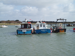
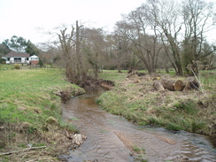
After this the path passed around the egde of Oxley marsh, before eventually settling on a more even course towards Keyhaven. This is an area that I quite like, and have visited Keyhaven several times since my coastal walk. For some reason this particular stretch of coast keeps on dragging me back. Lots of boats were moored at Keyhaven, and the car park, although not full, was starting to get busy.
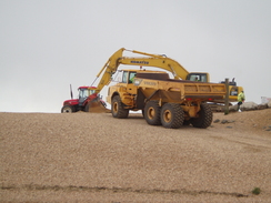
The full force of the wind hit me during the next stretch of the walk, and when I finally reached the shingle beach that leads off towards Hurst Castle at the end of the promontory I decided not to follow it. The breeze was one reason for this; walking along the shingle is not nice at the best of times, yet alone in a breeze. However the main reason was that there was lots of plant operating in the beach; a digger and large dumper trucks. In the end I decided to leave the castle for better weather.
Instead I turned and headed along the beach in the other direction words Milford-on-Sea. A few spots of rain fell, and the grey cloud were very different to the sunny skies that had greeted the start of the walk. In Milford I nipped itno a pub, and had an omelette along with a pint. As I had not visited Hurst Castle I decided to change my route for the rest of the day, in order to make the distance walked reasonable. I still wanted to visit the two Sway towers, but the only routes I could find involved a great deal of road walking. In the end I quickly finished up my drink and headed off.
There was not much to report until I reached the little village of Hordle. I was passing a petrol station by a crossroads in the village, and suddenly a man in front of me started waving his arms around like a madman. I looked, and a woman was driving out of the petrol station with a tire that was about as flat as it could be. I joined him, and by the time the driver had gone fifty yards down the road she stopped. Frankly, I was surprised she had not noticed the moment she had set off.
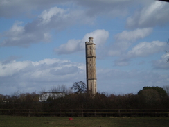
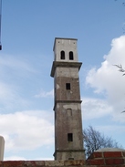
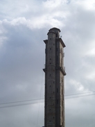
More roads and green lanes took me onwards, and off to the right I caught my first glimpses of the largest of the two Sway Towers. These were one of the reasons that I picked this route for the day, and the tall structure was as good as I had imagined. I took a long, looping route to get there, but eventually I was passing the smaller of the two towers (which had been built as a test), and then finally reached the main Sway tower. This is 218 feet tall, and is little more than a folly. Despite being made of unreinforced concrete it is a remarkably interesting structure. It is on private land, so unfortunately I could not climb it to see the views. The smaller tower nearby was built as a test before this dominating larger tower was built. There is a part of me which loves these follies; they seem to be exceptionally British affairs.
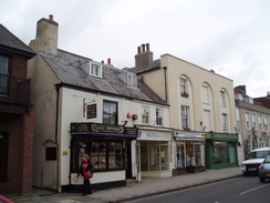
The road walking that followed was fairly boring, and I listened to the radio intently as I strolled along. It looked like there might be heavier rain at one stage, but the threatening cloud soon blew away. There was a fair on Pennington Common, with lots of fair vehicles strewn around. Even this could not divert me off the road. I entered the outskirts of Lymington, and a seemingly endless series of roads led me into the town centre. Eventually I reached the High Street, which was bustling in comparison with the quiet streets that had greeted me earlier. I then headed back to the car park and my car, happy after what had been an interesting walk despite slightly too much road walking.
 |
 |
|
 |
 |
|
Directions
This walk starts off at the car park in the centre of Lymington. Leave the car park, and follow the road downhill to Gosport Street, that runs through the town. Turn right to head southwards along Gosport Street, then turn left to head down to meet Quay Street. Turn right and follow Quay Street south-southeast for a hundred yards until it ends at Bath Road. Continue on along Bath Road, following it as it heads southeastwards, passing a marina and then a litlte park on the left, before reaching a car park by the lifeboat station. For the next few miles the path follows the Solent Way.
Pass the lifeboat station and then continue on as the path curves to the right, passing an outdoor swimming pool on the right. It then skirts the Lymington Yacht Haven on the left; after the water ends the path goes through an area of boats stored on dry land. Keep an eye out for the point where the path curves to the left, heading between the stored boats to jojn the seawall. Follow the seawall as it curves sinuously around.
Follow this sea wall as it curves around an area of marshes that is a nature reserve. The path winds in and out before crossing a slightly triangular creek by a sluice. Eventually the path settles on a south-westerly course before curving around to enter Keyhaven.
In Keyhaven the path along the sea wall ends at a narrow car park beside a road. Turn left and walk westwards along this road for a short distance until the footpath and sea wall turns off to the left once more. Follow the footpath around for another kilometre until a road is met before a wooden footbridge leads off over a stream straight ahead.
Cross the bridge and climb up onto the top of the shingle bank. Turn right and walk along the top of the spit into Milford on Sea. A promenade soon starts, and when a car park ii reached on the right turn right and follow Sea Road until it ends in the centre of the village.
Here the Solent Way is left behind. Turn left along the High Street for a short distance until it ends at the B3056; cross the B3056 and then head along Barnes Lane, which heads westwards before curving around to head northwards. Continue along Barnes Lane for a mile and a half until it ends at the A337 road.
Cross the A337 and continue on along a green lane on the other side. After half a mile the green lane meets the end of a road; here turn left along another Sky End Lane, which curves around to meet Hordle Lane. Cross Hordle Lane and continue on for 0.8 miles along Stopples Lane. When the lane ends at a T-junction with Ashley Lane turn right, and follow the road eastwards for half a mile; it soon crosses a crossroads and becomes Silver Street.
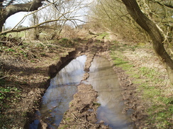
Shortly after Woodcock Lane leads off to the right, turn left up Agars Lane. The lane soon ends, and a green lane continues on for three-quarters of a mile, ending at Linnies Lane. The green lane continues on, but was very boggy, so I turned left down Linnies Lane foe a few yards until it reached the B3055, then turned right and carefully followed the twisting main road. It descends downhill; at the bottom of the hill turn right to follow the twisting Barrows Lane southwards. After half a mile turn left just before the larger of the two Sway Towers; follow Flexford Lane eastwards for half a mile until it ends at a T-junction With South Sway Lane.
Turn left and follow this lane northwards. Take the first lane off to the right, Kings Lane, and then take the first road off to the left, Coombe Lane, then right down Pauls Lane. When this meets Pitmore Lane cross it, and follow Mount Pleasant Lane as it curves around to the right. Take the second road off to the right, Morth Common Lane, and follow this until it ends at Pitmore Lane. Turn left and follow Pitmore Lane southwards for nearly halff a mile into Bowling Green.
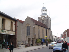
Cross Sway Road and continue on southwards down Ramley Road for a mile and a half. Just after Pennington Common ends on the right, turn left along North Street until it ends at the A337. Turn right and follow the A337 northwards for a third of a mile; when the road forks take the right-hand fork and follow this road as it heads eastwards downhill, becoming the High Street. Pass the church on the left, and then when New Street comes in from the left, turn down it and then right down Cann. Street to reach the car park where this walk started.
 |
 |
|
 |
 |
|
Distances
| From | To | Distance (m) | Ascent (ft) | Descent (ft) |
|---|---|---|---|---|
| Lymington | Milford on Sea | 8.2 | 154 | 184 |
| Milford on Sea | Hordle | 3.3 | 151 | 46 |
| Hordle | Lymington | 8.1 | 240 | 315 |
This makes a total distance of 19.6 miles, with 545 feet of ascent and 545 feet of descent.
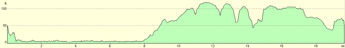
For more information on profiles, ascents and descents, see this page
 |
 |
|
 |
Disclaimer
Please note that I take no responsibility for anything that may happen when following these directions. If you intend to follow this route, then please use the relevant maps and check the route out before you go out. As always when walking, use common sense and you should be fine.
If you find any information on any of these routes that is inaccurate, or you wish to add anything, then please email me.
All images on this site are © of the author. Any reproduction, retransmissions, or republication of all or part of any document found on this site is expressly prohibited, unless the author has explicitly granted its prior written consent to so reproduce, retransmit, or republish the material. All other rights reserved.
Although this site includes links providing convenient direct access to other Internet sites, I do not endorse, approve, certify or make warranties or representations as to the accuracy of the information on these sites.
And finally, enjoy your walking!
Nearby walks
| # | Title | Walk length (miles) |
|---|---|---|
| 309 | Fawley to Bucklers Hard | 15.4 |
| 310 | Bucklers Hard to Milford on Sea | 19.0 |
| 311 | Milford on Sea to Southbourne | 16.9 |
|
|

|