Walk #835: A walk from Bursledon to Southampton
 |
 |
|
General Data
| Date Walked | 15/03/2009 |
| County | Hampshire |
| Start Location | Bursledon station |
| End Location | Southampton Central station |
| Start time | 09.48 |
| End time | 14.33 |
| Distance | 10.8 miles |
| Description | This was a lovely walk following the western side of the River Hamble and then the northern side of Southampton Water into the centre of Southampton. |
| Pack | Today I carried a very light pack, without the breast pockets. |
| Condition | I feel absolutely fine after this walk. |
| Weather | I have no idea what today's weather was like, as I forgot to fill this field in! |
| OS map | Landranger number 196 (The Solent & The Isle of Wight, Southampton & Portsmouth) |
 |
 |
|
 |
 |
|
Map of the walk
Maps courtesy of Google Maps. Route for indicative purposes only, and may have been plotted after the walk. Please let me have comments on what you think of this new format. For a detailed table of timings for this walk, please see the table file.
 |
 |
|
 |
 |
|
Notes
Sencan and I fancied doing a short walk today, and so we chose to do this stroll along the coast into Southampton. It was a walk that I did on Christmas Day 2002, and I had fond memories of it. We had attempted to do it just before the turn of the year, but Sencan had problems with ehr feet that had made us cut it short. Now that she had a new pair of boots, it felt like a good time to try this walk again.
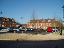
The car park at Bursledon station was quiet when we got there, and we were soon ready for the off. Bursledon village itself is lovely, with lots of nice, expensive-looking houses. I am unsure how much it costs to live in this area, but I can imagine that the house prices are expensive. It has everything; Two nearby cities (Southampton and Portsmouth) and easy access to London; a marina and sailing with plenty of lovely countryside around. Heck, I'd like to live there.
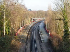
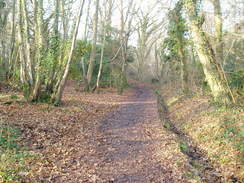
A series of roads took us past a pub and other similarly-expensive houses. Then a footpath dove downhill and then ascended through trees on Mallards Moor - the only time on the walk we would have this sort of scenery. Eventually a bridge over a railway line was reached - this was a little landmark. When we had tried this walk at the end of last year, Sencan had troubled with her feet at this early stage. Today, though, she had no problems, a sign that her new boots appeared to have solved the problems.
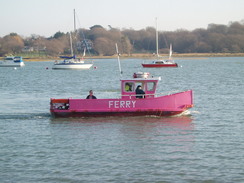
A long road walk took us down into Hamble-le-Rice. We nipped into a co-op in the centre of this lovely village before heading down to the waterfront. I sat on a bench near the lifeboat station as Sencan nipped into the public conveniences. I watched the colourful ferries making their way from one side of the River Hamble to the other - very picturesque.
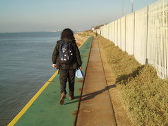
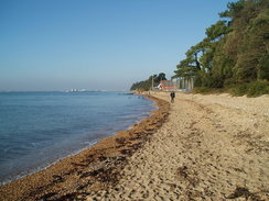
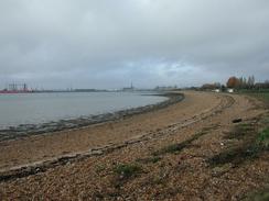
More road walking took us down past Hamble Common, where the Solent way took us along the northern side of Southampton Water. Ahead loomed a large jetty, which the path negotiated underneath as it passed an oil terminal. On the other side of the water were the tall chimneys of the Fawley oil terminal. The going after this was on shingle at times, both hard and time-consuming to walk along. Soon we headed off through some trees for a short distance, following a path over some low cliffs before emerging out at the southern end of the Royal Victoria Country Park.
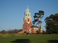
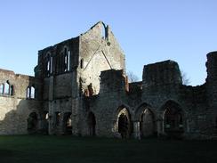
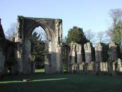
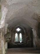
We sat on a bench here to have a short break before continuing on. To the right was the spectacular former chapel of the old military hospital, the only extant part of the massive building. The chapel looks strangely truncated and period photographs show why - the hospital stretched away from he church on either side. The going was easier along the tarmac, and soon we reach the public road in Netley. We continued on, soon passing the old Cistercian Abbey, which we had a quick glance at, before continuing on. This building had fascinated me on my last walk past here, on my coastwalk six years before.
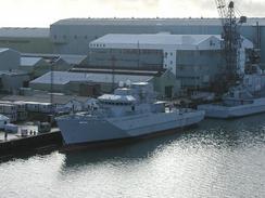
At Weston Hard the road curves away to the right, and a promenade continues on. It was warm and sunny, and the promenade was crowded. We stopped to have a quick ice cream from an ice cream van before continuing on. At Weston Point we left Southampton Water and joined the River Itchen; the path also curved away from the waterfront, passing a seemingly never-ending line of green hoardings. On the other side of this was the old site of the VT shipbuilding group, which closed after the launch of HMS Mersey in 2003. This seemed like a great shame; when I walked past here on Christmas Day 2002 the area had been bustling, but now it was just dead. The entire area will become yet more flats and houses.
Ahead loomed the graceful concrete curve of the Itchen Bridge. We climbed up the steps to this, then walked across the river. It was Sencan's first time over the bridge, and it was a shame that she did not get to see warships moored here, as I did on my walk in 2002. Now only one small part of a building remained, and no warships were moored. A long and familiar stroll through the centre of Southampton failed; what had seemed so new on my first visit was now normal.
We got to Southampton station to find out that bus services were replacing the trains that run back to Bursledon. This delayed out journey, and we were left sitting on a bench at the near-deserted station for a while before it arrived. Despite this, it had been a welcome and easy walk on a lovely sunny day.
Final note: All of the photos on this page were taken on previous walks along this route.
 |
 |
|
 |
 |
|
Directions
This walk starts off in the car park of the station at Bursledon. Leave the car park and turn left to head uphil along a narrow lane called Station Hill that is blocked by bollards about twenty-five yards up. At the top of the hill the lane widens and then forks. Take the right-hand fork along a road called High Street and when it ends at a triangular junction by a red phone box turn left, still following High Street.
High Street passes The Vine Inn and the junction with Salterns Lane, where High Street becomes Kew Lane. When the road curves around to the right take a footpath that leads off beside a cottage and heads downhill before ending at another road. Follow this road and when it curves around to the right head straight on along another footpath that heads downhill. The footpath crosses an unsurfaced track and then becomes a bridleway that heads uphill through a wooded area.
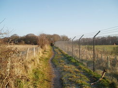
At a fork in the path turn left, still following the bridleway, and do not take the footpath to the right. When the bridleway meets a surfaced track turn right along the track for about ten yards and then turn left, following the bridleway as it heads beside a chain-link fence and out of the trees. The path and fence both turn to the left and continues on, before crossing a track and then the railway line by a bridge before ending at a road called Satchell Lane.
Turn left down the road and follow it as it twists and turns as it heads in a general southerly direction into Hamble. The road does not have a pavement, so care is needed on some of the bends. Satchell Lane ends at a roundabout in Hamble, and at this roundabout turn right through the town for a short distance before taking the first road to the left down School Lane. When this road ends at a T-junction turn left, still following School Lane. When School Lane ends at a marina by Southampton Water enter a car park beside the riverbank.
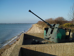
From the car park turn right past a Bofors anti-aircraft gun and take a footpath that leads on northwestwards. The path (called the Solent Way, which will be followed until the end of the walk) enters an area of brush land for a short distance before dropping down onto the foreshore and then climbing up onto the top of a seawall. The seawall passes under a jetty leading to a BP storage plant to the right and continues on until the seawall ends.
At the end of the seawall drop down onto the shingle beach and follow it as it heads northwestwards until it reaches the Royal Victoria Country Park. Here climb onto a surfaced path that parallels the foreshore as it heads northwestwards past a lovely brick building with a capper dome. Near the end of the park the path drops down to follow the top of the seawall until it ends at a little marina. Here turn to the right to join Victoria Road, which heads northwestwards through the village of Netley. Victoria Road becomes Abbey Hill near the ruins of the abbey before descending to meet the shore. Follow the road as it parallels the shore until it turns sharply to the right to head inland near a car park.
At the bend in the road continue straight on along a surfaced path that follows the beach as it continues northwestwards before turning to the right to head along the eastern bank of the River Itchen. Near a jetty the path ends at Victoria Road, which can be followed northwards past the site of the old large Vosper Thornycroft plant on the left (soon to become yet more flats and houses). When some steps are reached that lead up to the top of the imposing Itchen Bridge, climb them, and at the top of the steps turn left and cross over the river using the bridge. Before the end of the bridge cross over onto the northern side, and then take a zig-zag path that heads down to a subway. Continue westwards through this, and join the end of Chantry Road. When this ends climb up some brick steps to a long footbridge stretching over an old railway line; on the other side continue on along Marsh Lane.
A road comes in from the left, but Marsh Lane continues on northwestwards. At some traffic lights cross over, and head westwards through the East Street shopping centre to reach East Street itself. Head westwards along East Street until it ends at a T-junction with High Street. Turn right to head north up High Street, until the large stone building of Bargate is reached. from here, follow Above Bar Street northwards. When this meets Civic New Road, turn left along this road and follow it westwards, with the Civic Centre on the right. Cross Havelock Road at the traffic lights, then pass a steel structure and head down a path called Kingsbridge Lane. This passes a multi-storey car park on the right, then emerges out onto Blechnden Terrace. Head straight on westwards along this for a couple of hundred yards; Southampton railway station is on the left.
 |
 |
|
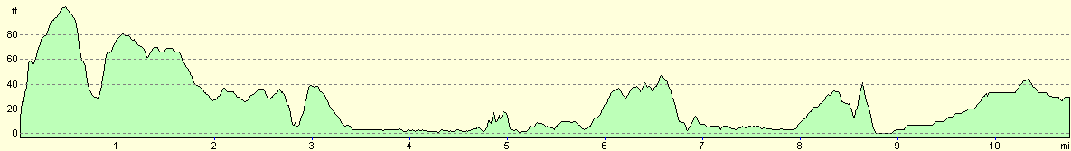
Distances
| From | To | Distance (m) | Ascent (ft) | Descent (ft) |
|---|---|---|---|---|
| Bursledon station | Hamble-le-Rice | 2.9 | 197 | 210 |
| Hamble-le-Rice | Itchen Bridge | 5.8 | 289 | 249 |
| Itchen Bridge | Southampton station | 2.1 | 46 | 59 |
This makes a total distance of 10.8 miles, with 532 feet of ascent and 518 feet of descent.
For more information on profiles, ascents and descents, see this page
Transport
There are regular train services between Southampton Central and Bursledon. See the National Rail Enquiries website for more details.
Disclaimer
Please note that I take no responsibility for anything that may happen when following these directions. If you intend to follow this route, then please use the relevant maps and check the route out before you go out. As always when walking, use common sense and you should be fine.
If you find any information on any of these routes that is inaccurate, or you wish to add anything, then please email me.
All images on this site are © of the author. Any reproduction, retransmissions, or republication of all or part of any document found on this site is expressly prohibited, unless the author has explicitly granted its prior written consent to so reproduce, retransmit, or republish the material. All other rights reserved.
Although this site includes links providing convenient direct access to other Internet sites, I do not endorse, approve, certify or make warranties or representations as to the accuracy of the information on these sites.
And finally, enjoy your walking!
Nearby walks
| # | Title | Walk length (miles) |
|---|---|---|
| 305 | Tipner to Browndown | 18.9 |
| 306 | Browndown to Bursledon | 12.9 |
| 307 | Bursledon to Southampton | 9.2 |
|
|

|