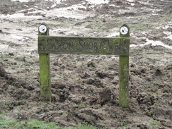
Walk #972: Saxon Shore Way: Twinney Wharf to Sittingbourne
 |
 |
|
General Data
| Date Walked | 10/01/2013 |
| County | Kent |
| Start Location | Twinney Wharf |
| End Location | Sittingbourne station |
| Start time | 08.00 |
| End time | 13.15 |
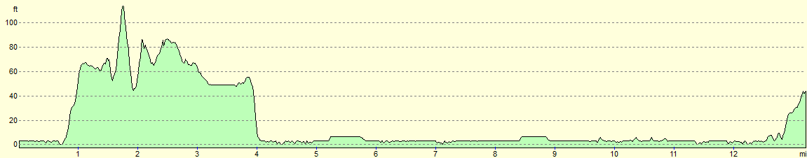
| Distance | 13.2 miles |
| Description | This should ahve been an easy walk around the coast past the Isle of Sheppey towards Sittingbourne. Sadly, ground conditions made it a bit of a tired slog. |
| Pack | Today I carried my Macpac Glissade rucksack containing my North Face Westwind tent, spare clothes, waterproofs, water, and enough food for two days. In total it weighed about thirty-five pounds. |
| Condition | I am in a fairly poor state after this walk; I have banged my head and am feeling very footsore. I feel worse than I have after a walk for some time. |
| Weather | Today started off cold, frosty, and misty; the mist soon lifted and was replaced with light cloud that never really threatened any rain. It was a warm day for the time of year, with little breeze. |
| OS map | Landranger number 178 (Thames Estuary, Rochester & Southend-on-Sea) |
 |
 |
|
General Walk Information
| Leg | To | Time | Grid reference |
|---|---|---|---|
| 1 | Twinney Wharf | 08.00 | TQ8565368081 |
| 2 | Lower Halstow church | 08.16 | TQ8601767148 |
| 3 | Footpath near brickworks | 08.40 | TQ8750567683 |
| 4 | Footpath | 09.06 | TQ8816767891 |
| 5 | Road | 09.36 | TQ8940968729 |
| 6 | Buildings on the marshes | 10.04 | TQ8857569940 |
| 7 | Flood bank junction | 10.24 | TQ8943270802 |
| 8 | Flood bank junction | 10.45 | TQ9041869658 |
| 9 | Swale bridge | 11.06 | TQ9130869227 |
| 10 | Footpath / road junction | 11.28 | TQ9169068220 |
| 11 | Bend in flood bank | 11.49 | TQ9225367407 |
| 12 | Track | 12.10 | TQ9243966255 |
| 13 | Under the new bridge | 12.30 | TQ9196565211 |
| 14 | Flood bank | 12.52 | TQ9113864489 |
| 15 | Sittingbourne railway station | 13.15 | TQ9056763881 |
 |
 |
|
Notes
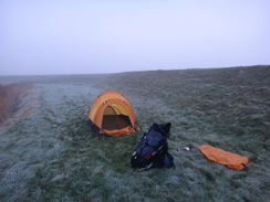
I slept well in my tent despite the frost, but the bitter cold hit me the moment I pulled my head out of my sleeping bag. Sadly a combination of my rather aged Westwind tent, the cold and a lack of wind meant that there was terrible condensation, with water dripping off the inner; worse, the end of my sleeping bag was wet. When I got out of the tent I was unsurprised to see a thick covering of frost on the flysheet, along with a haze of freezing fog.
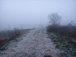
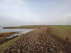
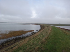
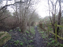
Dawn soon came, and I quickly pulled my tent down and packed up. I normally keep the fly and inner separate to prevent the damp fly soaking the inner, but there was little point in taking this precaution today. For this reason I decided that this would be the last day of this trip as I did not fancy spending a night in a sodden tent. Happy with this decision, I headed off down the trail. The path along the top of the flood bank was very muddy in places, especially by the clapper gates that guarded the separate fields. Wood chippings had been strewn around some stretch of path, the frost-covered bark looking strange in the fog.
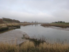
Eventually the going became easier as it passed an area known the Brickfields; presumably an area where clay was once dug. There were plenty of bushes around, and this would have been a much more private area to camp than the exposed location I chose last night. Nearby a large sailing ship was pulled up by a jetty; a sign said that it served tea, but there was no way it was going to be open at this early hour.
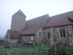
A road took me past a pretty little church, after which a path led east before joining a road. What followed was one of the worst stretches of path I have done for some time: the trail leaves the road and climbed uphill above a brickworks. Boggy ground underfoot made the climb difficult and far more strenuous than it should have been. Navigation in the hazy skies was also difficult and I headed in the rough direction across a large field, having to climb back uphill before crossing a track to enter an orchard.
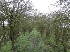
The path through the orchard was very muddy and rutted, but eventually the road below came into view. At the track I had moved off one sheet of the map onto another sheet, and I realised immediately that I should not be able to see the road. By putting the two sheets together I could see where I went wrong: the path entered the orchard for a few yards before going through the hedge into another field. Grumpily I headed back through the orchard back towards the track but still could not find the correct route. Eventually I found a gap in the hedge and a waymarker, directing me the right way.
Sodden ground made the going no easier along the top of the hill. Soon I came to a low, grassy bank that I had to go down; as I prepared to step down, a foot shot away from under me, quickly followed by the other. My bottom and rucksack took the majority of the impact as I fell. I yelled in surprise as much as pain then sat down as I took stock. Aside from a slightly sore bottom I felt okay, although my watch strap had snapped and was lying on the grass beside me.
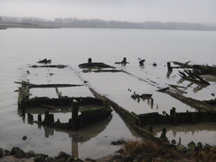
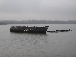
I pulled myself together and stood. My legs felt fine and I stumbled off along the path. It was a relief when the trail joined a track that passed a farm, before joining a lane. A descent down a grassy field took me back to flood banks that guarded a creek. The path at the top of the bank was muddy in places as it passed a series of rotting boats whose hulls were deep-down in the mud. Most were just a few ribs sticking up from the mud, but one was slightly more substantial. There is something romantic about old boat wrecks, their history and construction in plain view as nature reclaims them.
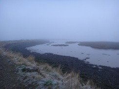
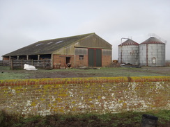
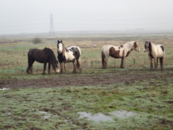
The trail diverted around a little rectangular patch of land before heading towards a building that is presumably used by farmers. Some ponies showed an inordinate interest in me as I passed, and they followed as I headed away along an old seawall inland. Marshland can appear dark and dangerous at the best of times, and in todays weather it seemed doubly so. It must be a lonely place; no wonder the ponies tried to follow me!
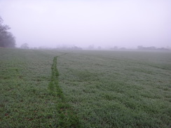
The going became easier when I reached a track that stretched across the marshes, after which another track took me on towards the eastern edge of the peninsula. At the end another floodbank was joined; off to the left was a gate with dramatic signs forbidding access to prevent nesting birds being harmed. Whilst I understand the reason, it seems rather a shame that the rest of the marshes are not accessible to the public.
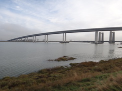
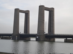
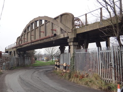
Another floodbank took me towards the massive bulk of the Swale Bridge ahead. The graceful span of the high bridge only opened a few years ago, and had not been present when I had last walked this route ten years ago. It is very impressive, and it probably took too much of my attention. Suddenly I found myself falling head-first towards the ground in front of me. My rucksack shifted forwards and my head hit the grass hard. Stars shimmered in my head and for a brief moment I wondered if I had done myself some great harm. Once my head cleared, I rolled onto my side and examined the damage. Aside from a sore head, my right ankle had twisted when it slipped into the rabbit hole that had caused the mischief. I gathered my wits and got to my feet, gingerly testing my ankle.
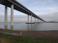
I had not done too much damage to my ankle and I limped on as a headache started to throb in the front of my head. I took my time reaching the bridge where I could cut the walk short at the nearby railway station; however I was feeling reasonable, and so continued on. The new bridge soars impressively overhead; behind it is the old lift bridge that carries a second road and railway line onto the Isle of Sheppey.
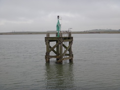
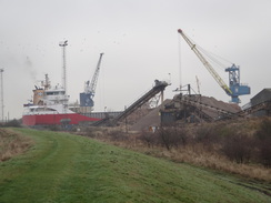
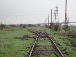
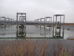
Soon I reached Ridham Dock, a large dock area that was bustling with activity. The old railway line leading into the works had not been used for a few years but looked as though it could be reinstated without much difficulty. The path around the perimeter of the works was narrow in places and overgrown, but it was just about passable. Things improved as the path joined the perimeter road for a short time, before continuing on to rejoin the flood bank.
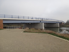
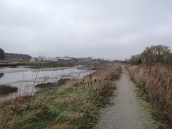
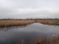
By now my feet were starting to ache, probably a result of the previous two days walks and damp feet. They started to get worse as I followed the flood banks south past Kemsley Marshes, which is a very industrialised area that seemed grim in the grey weather, with mud underfoot. There was nothing for it but to put my head down and just walk. I soon reached a new bridge across the river which would give a better route for any coastal walker, without having to walk down into Sittingbourne.
Eventually the site of Kemsley Down station was reached on the Sittingbourne and Kemsley Light Railway, which uses the narrow-gauge tracks of an old industrial line. The railway nearly shut a few years ago when the factory closed, but fortunately it has been saved. Much of the riverside south of the new bridge has been improved with a good path underfoot, benches and artwork. It made the walk easier on my aching mind, if not on my aching feet.
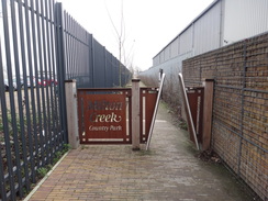
There was one last annoyance on the day, when the path diverted away from the creek to reach a road on the outskirts of Sittingbourne. The road was guarded by another one of the barriers that had bedevilled me yesterday, except this time there was no fence I could clamber over alongside. Instead I had to get down on my hands and knees and squeeze under the barrier. By this time I was very fed up, and even the rather fascinating concrete viaduct that carries the railway overhead could not improve my mood.
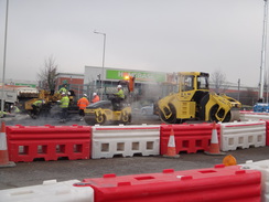
The roads outside Sittingbourne station were being worked on, and machines shuffled around as other workmen were putting the finishing touches to a brand-new Morrisons supermarket. My choices for the rest of the day were very limited; I needed to take my boots off for an hour or so to allow my feet to rest, but that would make it difficult to reach the next station, Teynham, before it got dark. I had also decided not to spend another night in my tent, which meant that I would have to stop this walk early, after a very short walk. A pub opposite the station was open, so I went in to buy a bitter shandy and consider my plans.
As I supped my drink I decided to call it a day. I went out and stripped off my gaiters and waterproof trousers, then returned for another drink. A train was due in a little over half an hour, and so I ordered another pint as my aching feet started to cool down. The return journey went well, and Sencan picked me up from St Neots to drive me home.
It had been an interesting three days of walking, including my first January camp for years. Sadly the trip had been let down by the muddy terrain, a sign of the rainy autumn we had suffered.
 |
 |
|
Directions
This walk starts off just to the south of Twinney Wharf at TQ856680. Head south along the path that runs along the top of the flood bank, going through a couple of clapper gates before the path opens out into scrubland on the right. The path curves to the right before passing a small quayside. Walk along the quayside and climb up a bank and down steps to reach a path in Lower Halstow. Turn left along the path; it immediately crosses a bridge over a creek, and then passes Lower Halstow church on the left. Soon afterwards the path ends at a T-junction with a road at TQ861673.
Cross the road, and on the other side take a footpath that runs between a hedge and fence. When the fence ends, cross a green track to reach a clapper gate into an area of paddocks. Go through a series of clapper gates across the paddocks to enter an orchard, and then head straight on between rows of trees. The path curves slightly to the left as it leaves the trees, passing close to a cottage on the left, before curving to the left and running between fences before rejoining the road at TQ865673. Turn right and follow the road east for a quarter of a mile.
Immediately after a road comes in from the right, turn right along the road for a few yards and then left through a clapper gate to enter a field. Head diagonally across this field, aiming for the far right-hand corner. Go through a stile to enter a second field, aiming for some trees in the far right-hand corner. Shortly after crossing a track, go through a clapper gate to enter a third field, and turn slightly to the left to head towards the Funton Brickworks, angling away from the fence on the left. Go through a clapper gate into a fourth field and turn half-right too head uphill eastwards across the field, skirting some trees on the left. After a fifth of a mile turn slightly to the left to take a rough track more northeasterly course across the field (the track may be obscured by crops). When the eastern edge of the field is reach, go through a gap in a hedge to reach a track at TQ879678.
Cross the track and go through a gap in the hedge to enter the corner of an orchard. Keep the hedge on the right; after a few yards turn right through the hedge, then left across a narrow band of scrubland that leads out through a gap in a fence into a field. Head east across the field, and then go past a barrier and continue between two lakes. Once past the lakes, descend a small bank, cross an area of rough ground, and head straight on across a field. Cross a track and then head straight on between two fields, with a lake off to the left. Head diagonally across the field to the right, aiming for two squeeze barriers beside a field gate.
Go past the barriers to enter another field. Head diagonally across this field, aiming for a broad gap in the hedge ahead near the far corner, and then follow a fence on the left. The fence curves to the left and heads towards a farm. In the corner of the field go through a clapper gate to reach the end of a track with Raspberry Hill Park farm on the left. Continue along the track as it winds away from the farm; after a third of a mile, turn left to head diagonally across a field, aiming slightly to the right of some telegraph posts. When the edge of the field is reached, turn left to head towards the corner. Go through a clapper gate to reach a road at TQ894687.
Turn left along the road for a few yards, then turn right through a clapper gate to enter a field. Follow a fence and then a hedge on the left downhill; at the bottom turn left through a clapper gate and climb to the top of a flood bank. Turn right and follow the floodbanks as it heads in a rough northwesterly direction for three-quarters of a mile, going through a couple of clapper gates on the way. The path curves sharply to the left, right and then right once more to pass around the edge of a little peninsular to reach the southern bank of an inlet. Initially follow the inlet on the left, but then join a fence on the left that takes you away from the water and on towards a barn at TQ885699.
Pass the gate that leads into the barns compound on the left, and then turn right to join a small flood bank. Follow this as it winds around in a rough easterly direction for about a third of a mile until it reaches a clapper gate that guards a surfaced track. Cross this and head straight on through a clapper gate to join a firm track that twists and turns as it heads northeastwards, before reaching the western bank of the Swale at TQ894708. Turn right to start following the floodbank south, keeping the water to the left. Go through any clapper gates you reach; after 1.7 miles the Swale bridge is reached at TQ913692.
Pass under the high bridge and continue on past an expanse of tarmac towards the Kingsferry lift bridge. When the bridge is reached, turn right down some steps and through a squeeze stile to reach a road. Turn left along the road and follow it immediately under the approach to the Kingsferry lift bridge. As the road curves to the right on the other side, turn left through a gap in a fence to join a short footpath that leads up to a track. Turn right along the track; as it curves to the right, turn left to climb up onto the top of a flood bank.
Turn right and squeeze through a gap in a fence to start following the floodbank southeastwards. After a third of a mile Ridham Dock is approached; just before the fence guarding the dock is reached, turn right to drop off the bank and join a lower bank that is flanked by close-set hedges. After a short distance the bank ends. Cross the access road into the dock, and on the other side climb back up onto the bank.
Go through a clapper gate and follow the bank for another 250 yards before going through another clapper gate that guards a railway track that leads into the dock complex. Climb back up onto the bank, turn right through a gate and then continue along the bank. After another 200 yards the path curves to the left, descends off the bank and goes through a clapper gate to join a good-quality track. Follow this east-southeastwards for a fifth of a mile until a roundabout on an access road into the dock is reached at TQ920680.
Cross the roundabout and climb up some steps onto the flood bank on the other side. Follow the bank eastwards for a fifth of a mile until the bank ends at a larger bank. Climb up onto this and turn right to start following it south. After 0.7 miles a sewage works is reached at TQ921670. Here the bank turns to the left and becomes a firm track that leads under a conveyor belt. Immediately after the belt, go through a gate and rejoin the bank as it winds around past Kemsley Marshes, still in a rough southerly direction. After three-quarters of a mile a factory is approached at TQ921661.
When a gate blocks the way ahead, turn left along a path that soon enters some scrubland as it skirts past the factory, before rejoining a bank once more. Continue along the obvious path as it heads south, and after another half mile passes under a new bridge that carries Swale Way overhead. On the south side of the bridge, continue along an obvious and well-made path. After a mile the path turns to head inland between fences. Go through a squeeze stile to reach Gas road at TQ907645.
Turn left along this road, and follow it as it curves right to head under a railway viaduct and reach the B2005 Mill Way. Turn left to follow the pavement for a short distance until a roundabout is reached. Take the first exit on the left, and follow this road south-southwestwards. Soon it curves to the left to reach a second roundabout. Here take the first exit on the right, Milton Road, passing a Morrisons store and passing under a railway line. On the other side the road curves to the left to reach another roundabout next to Sittingbourne railway station at TQ905638.
 |
 |
|
Distances
| From | To | Distance (m) | Ascent (ft) | Descent (ft) |
|---|---|---|---|---|
| Twinney Wharf | Swale Bridge | 7.9 | 292 | 292 |
| Swale Bridge | Sittingbourne station | 5.6 | 98 | 56 |
This makes a total distance of 13.0 miles, with 390 feet of ascent and 348 feet of descent.
For more information on profiles, ascents and descents, see this page
 |
 |
|
 |
 |
|
 |
 |
|
 |
 |
|
 |
 |
|
 |
 |
|
 |
 |
|
 |
 |
|
 |
 |
|
 |
|
|
 |
 |
|
 |
Disclaimer
Please note that I take no responsibility for anything that may happen when following these directions. If you intend to follow this route, then please use the relevant maps and check the route out before you go out. As always when walking, use common sense and you should be fine.
If you find any information on any of these routes that is inaccurate, or you wish to add anything, then please email me.
All images on this site are © of the author. Any reproduction, retransmissions, or republication of all or part of any document found on this site is expressly prohibited, unless the author has explicitly granted its prior written consent to so reproduce, retransmit, or republish the material. All other rights reserved.
Although this site includes links providing convenient direct access to other Internet sites, I do not endorse, approve, certify or make warranties or representations as to the accuracy of the information on these sites.
And finally, enjoy your walking!
Nearby walks
| # | Title | Walk length (miles) |
|---|---|---|
| 176 | Gravesend to Rochester | 17.2 |
| 179 | Sittingbourne to Faversham | 13.9 |
| 286 | Cliffe to Hoo St Werburgh | 19.2 |
|
|

|