Walk #286: Cliffe to Hoo St Werburgh
 |
 |
|
General Data
| Date Walked | 04/12/2002 |
| County | Kent |
| Start Location | Cliffe |
| End Location | Hoo St Werburgh |
| Start time | 08.22 |
| End time | 15.05 |
| Distance | 19.2 miles |
| Description | This was another long walk along riverbanks which was followed by a long road walk back down the Hoo Peninsular. |
| Pack | I did not wear a pack due to the trouble that I had with my shoulder a few days ago. Instead I worse Sam's large bum bag, which meant that I was not bearing any weight on my shoulder. In the bag I carried some fruit and spare batteries. |
| Condition | I feel absolutely fine after this walk. I had a little shock early on, when I went over on my left ankle and had that horrible sort of adrenaline rush that I get when this happens. Fortunately this did not cause any long-lasting pain, and the aching stopped after about five minutes. |
| Weather | The sky was grey all day, and a light drizzle was falling for most of the morning, being blown in from my right-hand side which soon got wet although my left-hand side remained dry. As the day went on the drizzle became a light rain and by the time I was walking along the road it had become a heavy rain, indeed at one time it was the heaviest rain that I can remember on this walk. Fortunately after about an hour it lightened and then stopped, and towards the end of the walk there was a bright sky ahead, but this did not really help me dry out. |
| OS map | Landranger number 178 (Thames Estuary, Rochester & Southend-on-Sea) |
 |
 |
|
Map of the walk
Maps courtesy of Google Maps. Route for indicative purposes only, and may have been plotted after the walk. Please let me have comments on what you think of this new format. For a detailed table of timings for this walk, please see the table file.
Notes
I was in a bad mood all day today, for reasons that I cannot really adequately explain. I would say that I got out of the wrong side of the bed, but that is a physical impossibility in the campervan without cutting a hole in the roof first. I could blame it on the weather, but I was in a foul mood from the time I stepped out of the van, which was before it even started raining. Every little thing that happened today added to my increasing ill temper - the path not being walkable, the batteries on my mobile running out, even Sam phoning me up. All in all it was the first total joyless day of the trip so far, a real downer. The strange thing is that this ill temper only lasted for the duration of the walk - by the time that I was back in the van my mood had improved and I felt much better about things. This is very strange, a usually when I walk I take joy in things I see and experience, even in the rain, but today all of this was totally lacking.
Yesterday I had my first shave in three or four weeks, and I spent about ten minutes slowly shaving off the beard that had accumulated over that period. When I finished I looked about fifteen years younger than I had, which Sam seemed to approve of. Unfortunately the downside to doing this is that when he rain and wind was coming in from the right during the morning my right cheek got frozen numb. I had not bothered taking my balaclava with me for the last couple of weeks as a combination of thick beard and balaclava was too hot, but without the beard or balaclava my face was frozen. If I am going to remain clean-shaven over the winter then I shall have to buy a thick balaclava to try to stop this happening.
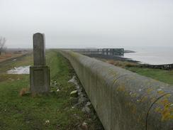
Near Lower Hope Point I came across a small stone monument sticking out of the ground at a slight angle. I went up to read this, but the carved lettering on the face of the monument was very fine and I could not easily read it. I had to position my head in such a way that the sky was reflecting off the surface to even be able to read bits of it. After a couple of minutes I had read all of it, and it was apparently a marker to denote the boundary of where the lightermen and watermen of the Thames worked. There was also other information, but unfortunately in the drizzle I did not want to stop to write it down. A little further on there were the shells of some abandoned buildings, roofless hulks that were lain out in such a manner that they had to be of military origin, but again I have no idea what they were for.
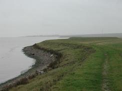
As I approached Allhallows-on-Sea there was a little stretch of beach which I decided to cut across to save a little distance. This was a silly thing to do however, as I walked for over five minutes before a channel coming in from the sea blocked my way and I had to retrace my steps and then jump over a smaller channel to get back to near where I had started the diversion. Later on the footpath joined a field for a short distance before diverting off to the left across the marshes. Unfortunately I could not take this route as there was a channel immediately beyond the stile that was too wide to jump across. There was a little plank bridge under the surface of the water, but I did not fancy having to walk across this. It may be that this footpath is only walkable at low tide, but there were no warning signs about this. I managed to divert around this blockage by walking on for about fifty yards to where a gate led through to a culvert across the channel. This got me back on to the original path, but later on there was a place where the path led out across the marshes to the edge of the river. I walked along the little bank to the river, but the path then diverted to the right over a larger channel. I decided that it was stupid to even consider trying to jump across this channel as the tide was coming in and I had no idea if there would be a blockage of some form or another at the other end of the path that could leave me trapped. I therefore made my way along the bank across the marshes to the first field inland and walked along this, which seemed the sensible thing to do.
All around the houses at Cliffe and Allhallows were signs saying 'no to the airport'. This is all due to the fact that Cliffe Marshes is one of three contenders in a recent government plan to increase airport capacity. The Cliffe part of the plan would see a new large airport built on the marshes, and understandably the locals are campaigning vigorously against this. The fight for keeping the marshes as they are may already be lost, however, as I saw footpath closure orders posted on the route which are a result of a planning application by P&O to build a new container terminal on the marshes. If this goes ahead then the walk along the riverbank will probably have to be diverted inland, but his is obviously a long way in the future.
This evening all my waterproofs and my boots were totally soaked after the rain (fortunately I had remained dry underneath them), so Sam decided to wash my clothes. This is the first time that my coat has been washed on the trip so far, and even I had to admit that it was starting to smell. This means that I will probably have to wear my other coat tomorrow, which is not really my favourite one. As my boots had been washed by rain they were probably the cleanest that they had been for weeks, so I also decided to wash and reproof them. Unfortunately in doing so I noticed that both boots had little breaks in the leather where the creases were on the side of the boot. This is probably why my feet got damp today (I had put it down to leakage from the top of the boots) and so it may soon be time to buy a new pair of boots. This pair of boots has lasted for about 1,100 miles, which is strangely enough right on my target for having five pairs of boots for the entire walk. The next pair I get will also be Karrimor boots, as this pair have been absolutely excellent and given me virtually blister-free walking.
Directions
This walk starts off by the end of a road beside a quarry just to the Southwest of the village of Cliffe, which is on the Hoo Peninsular to the north of Rochester. At the end of the road take a footpath that starts at a gate and follows a track that winds its way northwestwards until it ends at Cliffe Creek. When the creek is met turn right and follow a footpath along the northern bank of the creek for a short distance until it meets the southern bank of the River Thames.
Follow the path as it heads northwards along the Thames for a little over a mile until Lower Hope Point is reached, where the river turns to the right to head eastwards. The next few miles are very straight forward; simply follow the footpath along the riverbank eastwards for many miles, passing Egypt Bay and St Mary's Bay before it heads slightly inland past some marshes before ending at a large holiday park in Allhallows-on-Sea.
Here I walked through the holiday park and down it's entrance road southwards until I reached a T-junction in a road in Allhallows. At this junction had straight on southwards down a road for a mile to Lower Stoke. When the A228 road is reached turn right along it for a few yards before turning down a road to the left that leads straight into Middle Stoke.
In Middle Stoke take a footpath that leads across fields before emerging at the church in Stoke. At the church turn left down a road that soon turns to head southwestwards for a little over a kilometre. Just after it passes under some power lines and before it meets a railway line it turns sharply to the right past North Street for a kilometre before turning to the left to head southwestwards. The road passes over a railway line before ending at a T-junction with another road that leads to an industrial estate. At the junction turn to the right and follow the road as it heads southwestwards for a couple of kilometres into the village of Hoo St Werburgh. This walk ends in the car park beside the crossroads in the centre of the village.
Distances
| From | To | Distance (m) | Ascent (ft) | Descent (ft) |
|---|---|---|---|---|
| Quarry in Cliffe | Allhallows-on-Sea | 12.6 | 135 | 138 |
| Allhallows-on-Sea | Hoo St Werburgh | 6.6 | 243 | 213 |
This makes a total distance of 19.2 miles, with 378 feet of ascent and 351 feet of descent.
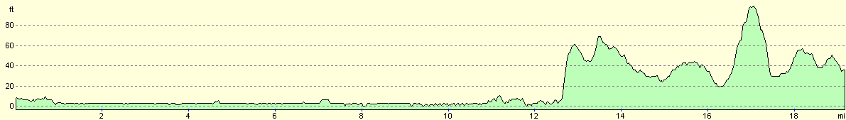
For more information on profiles, ascents and descents, see this page
Accommodation
We stayed at the Woodmans Wood Caravan and Camping Park, Rochester Road, Bridgewood, Chatham, Kent ME5 9SB. They can be contacted on 01634 867685. This is a nice site with some good facilities, which cost us twelve pounds per night. The toilets were clean, and the showers were nice and hot and, wonder of wonders, in a room that was actually heated!
Disclaimer
Please note that I take no responsibility for anything that may happen when following these directions. If you intend to follow this route, then please use the relevant maps and check the route out before you go out. As always when walking, use common sense and you should be fine.
If you find any information on any of these routes that is inaccurate, or you wish to add anything, then please email me.
All images on this site are © of the author. Any reproduction, retransmissions, or republication of all or part of any document found on this site is expressly prohibited, unless the author has explicitly granted its prior written consent to so reproduce, retransmit, or republish the material. All other rights reserved.
Although this site includes links providing convenient direct access to other Internet sites, I do not endorse, approve, certify or make warranties or representations as to the accuracy of the information on these sites.
And finally, enjoy your walking!
This walk was mentioned in the following routes:
| My walk around the coastline of Britain |
Nearby walks
| # | Title | Walk length (miles) |
|---|---|---|
| 161 | Gravesend to Dartford | 7.2 |
| 176 | Gravesend to Rochester | 17.2 |
| 279 | Little Wakering to Chalkwell via Southend-on-Sea | 18.9 |
|
|

|