Walk #287: Hoo St Werburgh to Lower Twydall
 |
 |
|
General Data
| Date Walked | 05/12/2002 |
| County | Kent |
| Start Location | Hoo St Werburgh |
| End Location | Lower Twydall |
| Start time | 09.55 |
| End time | 14.37 |
| Distance | 11.9 miles |
| Description | This was a highly enjoyable walk which took in a couple of castles, a cathedral and a historic dockyard. |
| Pack | Today I carried my 30-litre Karrimor HotRock rucksack, which was filled with my packed lunch, waterproof leggings, water bottle and a couple of spare shirts, together with the usual assortment of odds and ends. |
| Condition | I have had a major problem with my left ankle today. About an hour after setting out it started aching whenever I moved my little toes, and fairly soon this became pain. I considered cutting the walk short, but as the pain only occurred when my toes moved I decided to continue on regardless. It remained bad for the duration of the walk, but fortunately it did not get any worse. If it is like this tomorrow then I shall have to consider taking a day or twos rest. Aside from this everything is fine, which is to be expected after such a short walk. |
| Weather | The weather today was mainly cloudy with some prolonged sunny periods, which was a nice change after yesterdays rain. There was no sign of any rain but it was fairly cold, particularly early on when it was quite bitter. |
| OS map | Landranger number 178 (Thames Estuary, Rochester & Southend-on-Sea) |
 |
 |
|
 |
 |
|
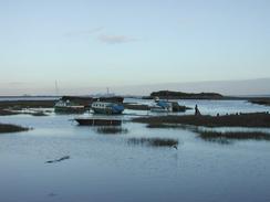
Map of the walk
Maps courtesy of Google Maps. Route for indicative purposes only, and may have been plotted after the walk. Please let me have comments on what you think of this new format. For a detailed table of timings for this walk, please see the table file.
 |
 |
|
 |
Notes
It had been our intention to set off early on the walk this morning, but this did not turn out to be the case and instead it was a very late start. This was because I spent a few hours getting the data on my website up to date, and although the job is not yet complete (five recent walks do not yet have directions written up) the rest of the data is up to date. Writing up the walks takes me a long time each day, and it is starting to get to the stage where I wish I could stop it for a week or so. I shall continue for the moment, but I may just stop writing them up soon.
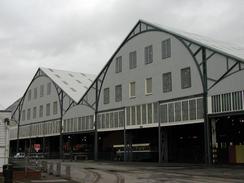
As I was walking down the A231 I suddenly saw Sam pass me in the van. I gave her a quick call, and we met up a few minutes later outside the historic dockyards at Chatham. As I approached the dockyard I recognised one of the building as one that I had seen on television before. It is a magnificent building, and I was considering stopping the walk early when we found out that the dockyard was only open on Wednesdays, Saturdays and Sundays. I actually found this quite annoying, as I could see the building that I wanted to have a look around but could not get access to it.
I must admit that of all the places that I have been on the trip so far, the Rochester and Chatham area is one that I really want to visit again to explore the Castle, the cathedral and the dockyard. The towns themselves are not the most attractive, but these are attractions that I really want to see. There is also a Royal Engineers museum, which may not be everyones cup of tea but I could well find it quite interesting.
The first castle that I passed on this walk was Lower Upnor Castle, which is situated between Lower and Upper Upnor, and overlooks the River Medway. This castle is open to public, but only from April. The area around it was very wooded, so I had no idea what state of ruin it is in. The castle, now a national monument, seems remarkably intact. Work on the castle was started in 1561 and was completed in 1568, to protect war ships anchored in the Medway Estuary and the dockyards at Chatham.
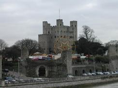
As I passed over Rochester Bridge I started getting some very good views of Rochester Castle. This is situated high up on the southern bank of the Medway Estuary, and its keep looked intact from where I viewed it. The sight of the caste nestled over the river was a lovely sight, and it was well worth my climbing up the hill to have a closer look at it. The castle was built in 1087 on the site of an older Roman castle (which protected the place where Watling Street crossed the river), and the keep is an imposing 104 feet tall. Unfortunately today a large funfair was being erected in the grounds of the castle, and it was very hard to get a view of the castle without a large Ferris wheel or tents being in it.
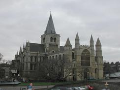
Rochester Cathedral was also very nice, although to my untrained eye it looks more like a French cathedral than an English one (I could be wrong in this, that is just my impression). I was muddy so I decided not to go into the cathedral, but I spent a few minutes walking around it so that I could get some good photographs of it. It is not my favourite cathedral, but it is possible to get a view with both the castle keep and the cathedral in, which is a hard view to beat.
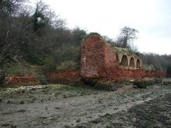
I am quite concerned about my ankle. I have no idea what has caused it to start aching. Early on in the walk I came across a section of the path through the woodland to the east of Lower Upnor, which was exceedingly narrow and overgrown. It could be that I had missed the real path and gone down a side one, or possibly the main path had been eroded away. The ground underfoot was very muddy, and I found myself at the top of an old brick wall. To my right was a steep, muddy slope and to my left a step descent to the foreshore, including a short vertical drop at the bottom. I decided that the latter approach was the better one, and so I got down on my bottom and slid down the muddy slope. It could be that I hurt my ankle doing this, but I did not have any pain at the time and so I doubt that this was the cause. It could be the little problem that I had with it at the start of yesterdays walk, but again I doubt that it would start hurting like this so long after the event. It is probably just one of those things, and I really do not mind what has caused the problem as long as it goes away quickly.
When we got back to the caravan site one of the first things I did was to plug in the computer so that I could do some work. I put the keyboard to one side whilst we had dinner, but then the power went out. One of the things about living in a campervan is that you learn to keep torches close at hand; I checked the trip in the van which was okay, so I went out to check the fuse in the electricity supply tower, which was fine. The site owner than came across, and the electricity around the whole local area was out. Fortunately after a couple of hours it came back on, and so I could get working again.
I wish that every day of the walk could be as interesting as this one - it makes a big difference to all the sea wall walking that I have done over the last few weeks. It is quite strange that yesterday I was in a bad mood, and yet today when I have had significant problems with my ankle I am strangely feeling quit high. As of today I have completed twenty percent of the walk, which is quite an amazing feeling, and we had a bottle of wine to celebrate. This also acted as a kind of anaesthetic which we both needed, as Sam has also been having a little pain today in her foot.
Directions
This walk starts off at the crossroads in Hoo St Werburgh at TQ78325 72168. The route mainly follows the Saxon Coast Path, but I made diversions from that route through Rochester and Chatham. From the crossroads head downhill to the south towards the church. Enter the church grounds and then turn left down a paved footpath to a car park and then a road. Turn right down this road to follow it southwards to a little industrial area. Take the first road to the right and follow this as it winds it's way to meet Hoo Marina.
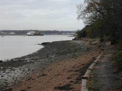
Follow the obvious pathway past Hoo marina until it ends at some woodland. In the woodland the path is indistinct; if the tide is out it would be better to walk along the foreshore all the way to the car park in Lower Upnor. If the tide is in walk carefully through the woodland as there is a steep drop in places down to the foreshore. Whichever route you take, continue on until a car park in Lower Upnor is reached.
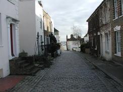
Leave the car park and follow the road southwestwards. After a short distance it starts to bend around to the right, and as it does so a path leads up some steps uphill to the left, beside a large and imposing wall. When the path ends at a road turn left along this road and then take another left, down the narrow and cobbled High Street that descends back down towards the River Medway. To the left of this road is Upnor Castle, which is now a National Trust property.
The road ends beside the river, and this route then turns right to head southwards along the frontage of the river. The road becomes a track and then starts to turn inland until it meets the A289, which at this point is a dual carriageway that leads down into the Medway Tunnel. The track follows the northern side of the dual carriageway for a short distance past a sewage works until a roundabout is reached. The path then continues straight on westwards, crossing the dual carriageway.
On the other side of the roundabout a path leads up a small but steep hill to meet another road at the top. This continues southwestwards, and when it bends sharply to the right the path continue straight on as it starts to descend past an old quarry.
The path ends at Canal Road at the bottom of a hill. Join this road and follow it southwestwards as it heads past Strood Station until Rochester Bridge is met. Climb up onto the bridge and turn left to cross the River Medway by means of the A2 road bridge. On the other side of the bridge turn right down a little road that leads to the gateway that leads up the castle. Pass through this gateway and continue up towards the castle keep. Continue across the castle grounds and then go through a gate to leave them, heading towards the cathedral. Pass the cathedral and then turn left down a narrow lane that leads a short distance to a road with many shops on it, which parallels the A2. Walk along this road as it heads southeastwards until it ends at a main road.
Continue along this road, again following the Saxon Shore Way, and follow it as it heads uphill to a roundabout. At the roundabout turn left and head eastwards along another main road until Hammond Hill road leads off steeply downhill to the left. Turn down this road and when it ends at a main road turn right until it ends at a T-junction with another road. Turn left down this road and follow it as it heads northwards through Chatham along a dual carriageway. At another roundabout continue straight on down Dock Road, passing over a roundabout which leads off to the left to the historic dockyard and reaches a roundabout with the A289 road immediately adjacent to the portal of the Medway Tunnel.
At this roundabout turn right and follow the path which descends alongside the slip road down to the A289. Follow the A289 road for about a mile and a half until a roundabout is reached which has a road leading off to the left that descends down to the leisure centre at The Strand. Head down this road to the leisure centre and then turn right to head along a path beside the river. This path follows the route of the Saxon Shore Way, which continues for a mile and a half to the car park of the visitor centre near Horrid Hill in Lower Twydall.
Distances
| From | To | Distance (m) | Ascent (ft) | Descent (ft) |
|---|---|---|---|---|
| Hoo St Werburgh | Rochester | 5.0 | 262 | 266 |
| Rochester | Lower Tydall | 6.9 | 325 | 351 |
This makes a total distance of 11.9 miles, with 587 feet of ascent and 617 feet of descent.
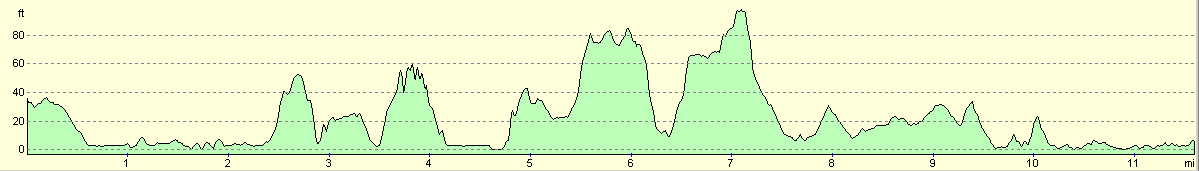
For more information on profiles, ascents and descents, see this page
Accommodation
We stayed at the Woodmans Wood Caravan and Camping Park, Rochester Road, Bridgewood, Chatham, Kent ME5 9SB. They can be contacted on (01634) 867685. This is a nice site with some good facilities, which cost us twelve pounds per night. The toilets were clean, and the showers were nice and hot and, wonder of wonders, in a room that was actually heated!
Disclaimer
Please note that I take no responsibility for anything that may happen when following these directions. If you intend to follow this route, then please use the relevant maps and check the route out before you go out. As always when walking, use common sense and you should be fine.
If you find any information on any of these routes that is inaccurate, or you wish to add anything, then please email me.
All images on this site are © of the author. Any reproduction, retransmissions, or republication of all or part of any document found on this site is expressly prohibited, unless the author has explicitly granted its prior written consent to so reproduce, retransmit, or republish the material. All other rights reserved.
Although this site includes links providing convenient direct access to other Internet sites, I do not endorse, approve, certify or make warranties or representations as to the accuracy of the information on these sites.
And finally, enjoy your walking!
This walk was mentioned in the following routes:
| My walk around the coastline of Britain |
Nearby walks
| # | Title | Walk length (miles) |
|---|---|---|
| 176 | Gravesend to Rochester | 17.2 |
| 281 | Stanford-le-Hope to Wennington | 16.9 |
| 285 | Stone to Cliffe | 13.6 |
|
|

|