Walk #288: Lower Twydall to Sittingbourne
 |
 |
|
General Data
| Date Walked | 06/12/2002 |
| County | Kent |
| Start Location | Lower Twydall |
| End Location | Sittingbourne Station |
| Start time | 08.20 |
| End time | 15.42 |
| Distance | 18.8 miles |
| Description | This was a nice walk following sea banks, creeks and roads in a very winding route. |
| Pack | Today I carried my 30-litre Karrimor HotRock rucksack, which was filled with my packed lunch, waterproof leggings, water bottle and a couple of spare shirts, together with the usual assortment of odds and ends. |
| Condition | I feel relatively fine after this walk, and have no major problems to report. My ankle, which was fairly painful yesterday, was better although far from perfect today. It still gave me small bouts of pain, but for the rest of the time it either ached or was absolutely fine, which is a vast difference from yesterday. I am still watching it carefully, and if it gets worse I shall have to act accordingly. Some other good news is that the pain in my shoulders has now gone, and I can wear my rucksack with no problems. |
| Weather | It was very overcast today, and there were drizzle showers all day, which I found highly annoying. There was also a blustery northeasterly wind, which could be very cold at times. I have most certainly had worse days on this trip, but I have also had much better. |
| OS map | Landranger number 178 (Thames Estuary, Rochester & Southend-on-Sea) |
 |
 |
|
 |
 |
|
Map of the walk
Maps courtesy of Google Maps. Route for indicative purposes only, and may have been plotted after the walk. Please let me have comments on what you think of this new format. For a detailed table of timings for this walk, please see the table file.
Notes
It was with not a little concern that I set out on the walk today. I knew that I had a long, eighteen mile plus walk to do, and I was worried about whether my ankle would last the distance. Within five minutes of setting out it started to ache, but after the hours passed it became obvious that it was in a better condition than it had been yesterday. Although I did get the odd short blast of pain and some longer periods of aching it withstood the walk well. The walk involved several different sorts of terrain and no one sort of terrain caused it more difficulty than any other, which is a good sign. It will take me a few more days to gain more confidence in it, but today was a good sign that it my be getting better.
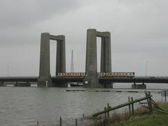
As I walked down the Swale, which separates the Isle of Sheppey from the mainland, I could see the four legs of the Kingsferry lift bridge slowly grow larger in front of me. This bridge was opened in 1959 and cost one million pounds to build. It is not a pretty bridge and looks somewhat like a table lying on its back, but is very functional. The bridge carries both rail and road links over to the Isle, which is a nice change from, many modern bridges where they refuse to build rail links as well. I took some photographs as I passed the bridge, and as I was walking away from it I heard a siren. I turned around and saw the barriers on the bridge come down and the traffic slow, so I sat down on the bank and watched the bridge lift and a small boat pass under it. This was an interesting sight that I found quite captivating.
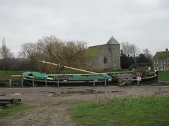
From my Ordnance Survey map I could see that the church in Upchurch had a spire, so I decided to slightly alter my route and walk into the village to see it. As I got closer I could see that it had a very unusual sort of spire, but when I reached it I found that the entire building was covered in scaffolding as it was under restoration by English Heritage. I found this deeply annoying, although it is great to see a church under restoration. I tried the door to see if I could take some interior photographs, but as I had expected the door was locked. I had more luck at Lower Halstow, where the church has a nice tower. Again the church was locked, but at least I could get some photographs of the exterior.
Sam has been in contact with Country Walking magazine, and they have asked us for some 300DPI photographs featuring some scenic areas and myself. I am unsure how many DPI the photos I have been taking are, and therefore I will have to wait until we have power so that I can start up my computer and see what I have.
I was incredibly tired tonight, and I went to bed at about seven so that I could have a lie down. I promptly fell asleep, and woke up again at midnight. I slept through until six in the morning, which shows exactly how tired I was. This has probably done me a lot of good, although I woke up more tired than I was when I went to sleep, which is often the case when I have a long sleep. This allowed me to digest the fish and chips that we had for dinner, and I woke up absolutely famished so I immediately demolished half a pack of ryvita, which temporarily filled the hole.
Directions
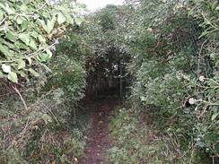
This walk starts off in the car park at the visitor centre of the Riverside Country Park in Lower Twydall. This walk mainly follows the Saxon Shore Way, although I did divert away from this route. Leave the car park and head eastwards along the sea bank, passing the remains of Bloor's Wharf before it turns sharply to the left to head northwards up a little peninsular. Here I joined the road, which runs beside the bank, because it was less muddy. When the road ends at the gates to a works turn to the right and hea ddown a footpath that leads down to the riverbank by Otterham Creek.
At the bank turn right and head southwards beside Otterham Creek. At the end of the creek the path turns to the left and the path heads behind a series of factory buildings before ending at a road in Otterham Qay. Turn left up this road and when it curves around to the right head left up a footpath which head up a little hill. At the top of the hill the path angles across an orchard before ending at a bend in a road on Windmill Hill. Follow this road as it heads northeastwards, curving into the little village of Upchurch.
When the church in the village is reached turn left up another road, and when this road turns to the right continue straight on down another road. As the road heads out of Upchurch take the first road to the left, which heads northwards for a little over a kilometre to Bayford. At Bayford the road turns sharply to the right to head eastwards for a fifth of a mile, before turning to the right once more to head southeastwards. Just past a Ham Green Farm the Saxon Shore Way is reached once more. Turn left down the Way and follow it as it heads northeastwards to the sea bank. At the sea bank turn right to head southeastwards for a couple of kilometres until a little track leading to the church in Lower Halstow is reached.
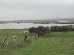
Turn left to follow the track past the church until it ends at a road. Turn left down this road and follow it as it curves around to the right and starts to head past Funton Creek. This road is called Raspberry Hill Lane, and at very hide tides the road is covered by the sea It was quite a quiet road, and I enjoyed the walk along it. The road then climbs up Raspberry Hill before meeting the Saxon Shore Way once more. Turn left and follow the Way as it heads downhill to the northwest. It meets the sea once more by Bedlam Bottoms and continues on alongside the bank until it ends by the channel separating the mainland from the little Chetney Hill.
At this point turn right and head across a field for a shot distance to a little farm. Enter the farmyard and then join a track that leads away from the farm to the east. This track curves around to the right, and just past a little metal tower turn left down another bank and track northeastwards as it passes under some power lines until it ends at the riverbank beside the Long Reach of The Swale. At the bank turn right as it heads southeastwards past Ferry Marshes until it reaches the Kingsferry Bridge
At the bridge the Saxon Shore Way descends to join a little road to head under the bridge, and on the other side of the bridge it climbs back up onto the bank once more. Follow the bank southeastwards for a short distance until it approaches Ridham Dock, where the path turns to the right along a little bank which heads south past the dock. It crosses over two railway sidings before turning to the left and joining a track that heads roughly eastwards along the southern end of the dock. At a muddy roundabout continue straight on until it reaches the bank of The Swale once more.
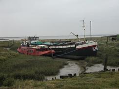
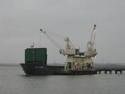
At the bank turn right and follow it as it heads southwards once more. It passes a dock where ships are unloaded and a conveyor system before turning off The Swale and starting the descent down Milton Creek which starts at Kemsley Down beside the tip of the paper mill. Follow Milton Creek southwards into Sittingbourne, where the path meets the B2005 road. Turn left to follow the B2005 for a shot distance to a roundabout, before continuing straight on down the B2006 road. At the next roundabout turn right to head under a bridge under the railway line, and on the other side follow the road as it curves to the left towards Sittingbourne Station, where this walks ends.
Distances
| From | To | Distance (m) | Ascent (ft) | Descent (ft) |
|---|---|---|---|---|
| Lower Twydall | Lower Halstow | 7.2 | 223 | 226 |
| Lower Halstow | Kingsferry Bridge | 6.3 | 197 | 200 |
| Kingsferry Bridge | Sittingbourne Station | 5.3 | 92 | 49 |
This makes a total distance of 18.8 miles, with 512 feet of ascent and 475 feet of descent.
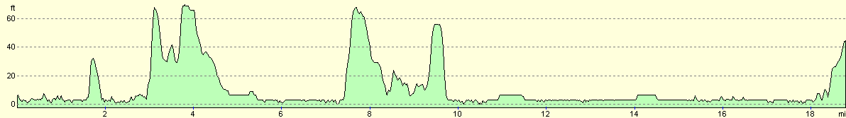
For more information on profiles, ascents and descents, see this page
Accommodation
There were no convenient campsites in the area so we parked on a street in Sittingbourne. We had two main criteria for where we parked; access to a pub so that we could go to the toilet and access to a chip shop so that I could have fish and chips for the first time since Clacton. Fortunately the street that we chose was fairly quiet, and we managed to get a good night's sleep.
Disclaimer
Please note that I take no responsibility for anything that may happen when following these directions. If you intend to follow this route, then please use the relevant maps and check the route out before you go out. As always when walking, use common sense and you should be fine.
If you find any information on any of these routes that is inaccurate, or you wish to add anything, then please email me.
All images on this site are © of the author. Any reproduction, retransmissions, or republication of all or part of any document found on this site is expressly prohibited, unless the author has explicitly granted its prior written consent to so reproduce, retransmit, or republish the material. All other rights reserved.
Although this site includes links providing convenient direct access to other Internet sites, I do not endorse, approve, certify or make warranties or representations as to the accuracy of the information on these sites.
And finally, enjoy your walking!
This walk was mentioned in the following routes:
| My walk around the coastline of Britain |
Nearby walks
| # | Title | Walk length (miles) |
|---|---|---|
| 176 | Gravesend to Rochester | 17.2 |
| 179 | Sittingbourne to Faversham | 13.9 |
| 286 | Cliffe to Hoo St Werburgh | 19.2 |
|
|

|