Walk #176: Gravesend to Rochester
 |
 |
|
General Data
| Date Walked | 13/01/2002 |
| County | Kent |
| Start Location | Gravesend Station |
| End Location | Rochester Station |
| Start time | 08.15 |
| End time | 14.35 |
| Distance | 17.2 miles |
| Description | This was a surprisingly nice walk, mainly following the Saxon Shore Way as it heads up onto the Isle of Grain before heading down to Rochester Bridge. This walk was along a mixture of footpaths and roads, with some good views of the Thames and Medway Estuaries available at times. It also passes three castles and an old fort, which provides high points of the walk. |
| Pack | Today I carried a 30-litre daysack containing Psion 5, spare base layers and fleeces, a mug and a pot of self-heating coffee. |
| Condition | I had been ill the week previous to this walk, so I was not certain whether I should attempt this walk. I had a few blisters on small toes on both feet, but these gave me no trouble today as I smeared Vaseline over my toes before I set off. Unfortunately a couple of hours into the walk I was sick, but after drinking a lot of water I felt slightly better and managed to continue on. Aside from this my legs and back are fine, and I had no other problems. |
| Weather | The main feature of today's weather was an ever-present haze, which fortunately was not thick enough to really spoil any views. The temperature was okay and I did not get cold except for a half-hour spell when I had to put my balaclava on. There was not much wind either, which also helped keep me cool. The exception was when I was on the raised sea banking near the beginning of the walk, when winds coming up the Thames made it feel cold. The only sight of any rain was near the end of the walk when approaching Rochester, when there was a slight drizzle for about twenty minutes. |
| OS map | Landranger number 177 (East London, Billericay & Gravesend) and Landranger number 178 (Thames Estuary, Rochester & Southend-on-Sea) |
 |
 |
|
Map of the walk
Maps courtesy of Google Maps. Route for indicative purposes only, and may have been plotted after the walk. Please let me have comments on what you think of this new format. For a detailed table of timings for this walk, please see the table file.
Notes
I had not been very well for the week prior to doing this walk, so I was on two minds whether to do a walk this weekend. My original plan had been to walk down from Boston to Spalding on Saturday, continuing the walk that I did last weekend, but I felt too ill to do this. On Sunday morning I felt slightly better, so I decided to do this walk instead.
When I reached Gravesend I parked my car in the St George's Car Park, which cost only 20 pence for the entire day as it was a Sunday. When I exited the car park I found myself next to St George's Church. Outside the church is a statue dedicated to Pocahontas, who was the daughter of an Indian Chief who is supposedly buried in the vault underneath the chancel in the church.
This walk had a fairly awful industrial beginning to it as the Saxon Shore Way headed between large industrial buildings and down unkempt roads. Once out of Gravesend the situation improved however, and the walks soon became far better.
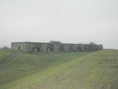
As I walked along the river I came across a strange half-ruined building pointing out towards the sea. It consisted of a large stone wall that was taller than me, with large arched holes in it, the holes being covered by what appeared to be metal plates. From the look of it I guessed that it was a military building, and that the holes used to contain guns to protect the river. When I got back home I did a search on the internet and found out that the wall was the remaining section of Shornemead Fort. I wish that I had known more about it before I did this walk, as it looks as though there is much of interest inside it.
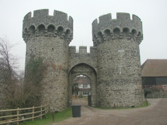
One of the highlights of this walks was seeing three castles - two in varying states of ruin and the last looking fairly complete. The first castle was at Cooling, between Cliffe and High Halstow. This was a fairly impressive ruin, with the gateway, some towers and some of the walks still extant. The moat was also visible and looked nice. Unfortunately 'private driveway' signs prevented any further exploration of the interior of the ruins. Although this castle is now about two miles inland from the sea, all the land between it and the sea is marshland, so I expect that the castle once stood by the sea and that the low-lying areas have been drained over the last few centuries. A search on the internet when I got home revealed that it had been built in or around 1382, in response to a combined Spanish and French fleet which had sailed up the Thames in 1380 and looted and burnt Gravesend and Tilbury.
The next castle was between Lower and Upper Upnor, where I passed a castle overlooking the River Medway. This castle was open to public, but only from April. The area around it was very wooded, so I had no idea what state of ruin it is in. Some more research when I got home showed that this was Upnor Castle, now a national monument, which seems remarkably intact. It was completed in 1568 to protect war ships anchored in the Medway Estuary and the dockyards at Chatham.
The last castle was visible as I passed over Rochester Bridge, and I did not pass by it, but it was still by far the most impressive. Rochester Castle is situated high up on the southern bank of the Medway Estuary, and it looked intact from where I viewed it. The sight of the castle nestled over the river was a lovely sight, and I intend to go and visit it sometime to have a closer look. Yet more research showed that this castle was built in 1087 on the site of an older Roman castle (which protected the place where Watling Street crossed the river).
When I got to Colling Castle I wanted to take some photographs of the fairly impressive remains. Unfortunately after taking the first photo the batteries in my camera ran out after about a month. I had been carrying spade batteries with me in case this happened, but they turned out to be flat because it had been so long since I had last charged them. This meant that for more than half of this walk I was left with no camera, which was a shame as there were some nice potential photographs that could have been taken later on in the walk.
It is rare when I am walking for me to find an unexpected view that makes me exclaim "wow!". Today had one of those moments when I was descending down Beacon Hill down to Lower Upnor and I got a view of the Medway Estuary for the first time. I do not know what caused me to give such an exclamation, but it was a lovely view when I glimpsed it through a clearing in the trees.
It had been my intention to follow the Saxon Shore Way to the fort at Cliffe and then head inland to Cliffe village. Unfortunately as I was passing Higham Saltings I phoned my girlfriend up. I continued walking whilst I was chatting to her, and by the time I had finished I noticed that the tide had come up and the marshy area was now covered in water. The path soon joined a large concrete wall on top of he banking which it followed towards some quarry workings. It was at this stage that I realised that for the first time in many walks I had gone wrong - whilst talking on the phone I had taken a branch in the path leading off to the right instead of taking the left-hand one. I studied the map and decided to continue on through the quarry rather than turning around as I was not feeling well and the route I had taken was actually going to be shorter (although it involved more road walking).
I had been feeling unwell for a week, and unfortunately this showed up a couple of hours into the walk, when I was sick. After having rinsed my mouth out with water I continued on, but I felt slightly unwell for the rest of the walk.
When I reached Hoo St Werburgh I decided that I was in need of a rest so I popped into "The Chequers" pub which is situated next to the church. I ordered a pint of Flowers IPA and then sat down. Sat next to me were two old gentlemen, and I had a nice chat to them whilst I drank my pint. One of them was from South Yorkshire, so I had a chat to him about that area for a while.
It had been my plan to walk as far as Gilingham, a few miles further on from Rochester. However when I was crossing Rochester Bridge I could see some rail workers and heavy equipment on the railway bridge beside me. Since this was the way I was due to get back to Gravesend I decided to pop into Rochester Station to see what the situation was. I was then told that the rail line was closed (as I had suspected), and that busses were running instead. I therefore decided to stop at Rochester as a bus was due to arrive in about ten minutes. This took me as far as Strood station on the western bank of the Medway, where I had to change onto a train for the rest of the journey back to Gravesend.
This walk sets me up well to follow the Saxon Shore Way east to Sittingbourne, and then on to Faversham. These two walks will get me within striking distance of both Canterbury and Margate, the latter of which will be about the halfway point of my coastal walk from London to Dover.
Directions
This walk starts off at Gravesend Station. Turn right out of the station and then turn left, to head north down the High Street. Continue straight on until you meet the shorefront of the River Thames.
Turn right and head eastwards along the shore, following the Saxon Shore Way. The initial part of this section is through an industrial area where navigation is fairly complex, but fortunately the Saxon Shore Way signs are frequent and clear. Eventually the riverside is reached again by some large dockside cranes and piers. Climb up some steps over a concrete wall and join the grassed riverside flood banking.
Head eastwards along the flood banking as it passes the Shorne Marshes. After about a mile and a half a large stone structure becomes visible immediately inland of the flood banking. This is the Shornemead Fort, and was quite an imposing structure.
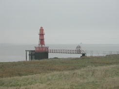
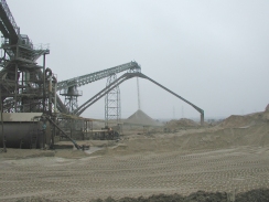
The flood banking continues on beside the river, crossing a stile near a lighthouse. The flood banking starts to head northeastwards across Higham Saltings until Higham Creek is reached. It was here that I went wrong; I had intended to continue along the Saxon Shore Way northwestwards along the coast to Cliffe Fort, but instead I turned right and headed inland past a large old flooded quarry beside a high concrete wall. This path comes out in the middle of a large working quarry, which the footpath heads through until it meets Salt Lane at TQ 7215 7575.
Join Salt Lane and follow it as it heads eastwards between two flooded quarries. After about a kilometre the road ends at a T-junction with another road. Turn left down this road for about a hundred yards and then take Higham Road, which leads off to the right. After a couple of hundred metres this road meets the B2000.
Cross the B2000 and head eastwards along Cooling Road for a kilometre until it ends at another T-junction. Turn left and then almost immediately right, to head eastwards along Cooling Road once again. The road climbs a slight incline and then turns sharply to the left and then the right, providing nice views of the little village of Cooling and the castle. The road then descends down into the village and passes the entrance to the castle. Pass the castle and continue on the road as it passes through a wooded area. Here the Saxon Shore Way leaves the road and continues on eastwards, but the route I took continues along the road as it descends down Lipwell Hill into a valley and then climbs up the other side and into the village of High Halstow.
Pass the church in High Halstow and take the first road to the right, Dux Court Road, which is just past the village church. Dux Court Road descends to a bridge over a railway line and then ascends again, passing Ducks Court. About a mile further on it meets the A228 road.
Cross the A228 and continue southeastwards along Bell's Lane down a slight hill through the village of Hoo St Werburgh. When you reach the church at the bottom of the hill enter the churchyard through the gate and turn right along the path. Pass to the right of a large stone mausoleum and leave the churchyard. At the end of the path turn right along it. Here the route meets the Saxon Shore Way once more, and the road becomes unsurfaced after a short distance as it climbs uphill for a kilometre to Hoo Lodge.
Continue on westwards past Hoo Lodge for another kilometre until a minor road is reached. Turn left and follow the road until it ends, and then descend down the hillside through some woodland along some muddy tracks. The paths come out on Upnor Road at Lower Upnor, on the western bank of the River Medway.
Turn right and follow the road southwestwards. After a short distance it starts to bend around to the right, and as it does so some steps lead off uphill to the left, beside a large wall. These steps end at a road. Turn left along this road and then take another left, down a minor road that descends back down towards the River Medway. To the left of this road is Upnor Castle, which is now a National Trust property.
The road ends beside the river, and this route then turns right to head southwards along the frontage of the river. The road becomes a track and then starts to turn inland until it meets the A289, which at this point is a dual carriageway that leads down into the Medway Tunnel. The track follows the northern side of the dual carriageway for a short distance until a roundabout is reached. The path then continues straight on westwards, crossing the dual carriageway.
A path then leads up a small but steep hill to meet another road at the top. This continues southwestwards, and when it bends sharply to the right the path continue straight on as it starts to descend past an old quarry.
The path ends at Canal Road at the bottom of a hill. Join this road and follow it southwestwards as it heads past Strood Station until Rochester Bridge is met. Climb up onto the bridge and turn left to cross the River Medway by means of the A2 road bridge. Once on the other side of the river remain on the eastern side of the A2 Corporation Street and follow it until it becomes a single carriageway road. Shortly after this turn left down the A2 High Street, and Rochester Station is almost immediately on the left.
Distances
| From | To | Distance (m) | Ascent (ft) | Descent (ft) |
|---|---|---|---|---|
| Gravesend Station | West Street, Cliffe | 6.2 | 89 | 118 |
| West Street, Cliffe | High Halstow | 3.7 | 240 | 98 |
| High Halstow | Lower Upnor | 4.1 | 272 | 440 |
| Lower Upnor | Rochester Station | 3.2 | 207 | 200 |
This makes a total distance of 17.2 miles, with 808 feet of ascent and 856 feet of descent.
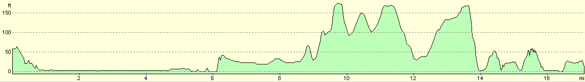
For more information on profiles, ascents and descents, see this page
Transport
There are regular train services running from Rochester back to Gravesend, although a change of trains may be necessary. There are also some bus services running between the two towns, although again a change may be needed.
Disclaimer
Please note that I take no responsibility for anything that may happen when following these directions. If you intend to follow this route, then please use the relevant maps and check the route out before you go out. As always when walking, use common sense and you should be fine.
If you find any information on any of these routes that is inaccurate, or you wish to add anything, then please email me.
All images on this site are © of the author. Any reproduction, retransmissions, or republication of all or part of any document found on this site is expressly prohibited, unless the author has explicitly granted its prior written consent to so reproduce, retransmit, or republish the material. All other rights reserved.
Although this site includes links providing convenient direct access to other Internet sites, I do not endorse, approve, certify or make warranties or representations as to the accuracy of the information on these sites.
And finally, enjoy your walking!
Nearby walks
| # | Title | Walk length (miles) |
|---|---|---|
| 161 | Gravesend to Dartford | 7.2 |
| 280 | Chalkwell to Stanford-le-Hope | 16.8 |
| 281 | Stanford-le-Hope to Wennington | 16.9 |
|
|

|