Walk #161: Gravesend to Dartford
General Data
| Date Walked | 14/10/2001 |
| County | Kent |
| Start Location | Gravesend Station |
| End Location | Dartford Station |
| Start time | 12.40 |
| End time | 15.12 |
| Distance | 7.2 miles |
| Description | This was a fairly boring walk along the A226 road, heading westward along the main road towards Dartford. |
| Pack | 30-litre daysack containing coat, trainers, digital camera and a spare top. |
| Condition | Okay. Sine this was all road walking I decided to wear my trainers instead of boots, and these proved fine as my feet did not ache and I have no new blisters. y legs and shoulders are fine, although I have suffered slightly form an aching back once the walk has finished, although I do not think that this was caused by the walk. |
| Weather | The weather started off as being fairly hot, with a few clouds in the sky. The early morning had been very foggy as I made my way down to London, but by lunchtime this had lifted and had been replaced by sunshine. As the walk progressed the sky started to cloud over and become grey, and at one stage I had a couple of spots of rain fall on me. Fortunately this was all the rain there was, and the rest of the trip was dry until I got back to my car and it started to drizzle. There was more wind than yesterday, which meant that I managed to keep cool despite the temperatures being high for the time of year. |
| OS map | Landranger number 177 (East London, Billericay & Gravesend) |
 |
Map of the walk
Maps courtesy of Google Maps. Route for indicative purposes only, and may have been plotted after the walk. Please let me have comments on what you think of this new format. For a detailed table of timings for this walk, please see the table file.
Notes
I had to make a trip to visit a friend in Purley today and drop off a piece of computer hardware to a friend. Once I had done so I had an afternoon free, and I had two alternatives; a walk along the North Downs Way or a continuation of my walk along the southern side of the Thames estuary. Since the former had not been one of my planned walks, I decided to do a short walk from Gravesend to Dartford.
This walk was very much a positional walk, the aim of which was to get me away from the outskirts of London so that I can progress toward the coast at Margate. As such it was never going to be a classic walk, and a long slog along main roads proved that to be the case.
Fortunately despite the fact that this walk follows the A226 for it's entirety I was lucky in that there was pavement at the side of the road for the entire walk. Despite the fact that it was a road walk there was still items of interest to see - although I am glad that I did the walk on a Sunday when the traffic was probably less busy than it could have been and hence I did not get choked by car and lorry exhaust fumes.
The Bluewater Retail Park at Stone dominates the area, and when I was driving to Gravesend I got caught in traffic queues on the A2 with traffic attempting to get there. It also seemed that most of the busses in the area go to the retail park, which means that a bus change may be necessary if travelling by bus between Dartford and Gravesend. The Bluewater Park itself must be quite impressive as it is the largest retail and leisure development in Europe, with 320 retail outlets sharing 150,000 square metres of floorspace. The complex cost 375 million pounds to build, and it was built on the old Blue Circle Western Quarry. For this reason it was hardly surprising that the roads nearby were busy with sunday afternoon shoppers.
I have driven over the Queen Elizabeth II bridge at Dartford a few times, and it was with interest that I saw it grow larger as I walked towards it. I have a keen interest in large civil engineering projects, and one of my old lecturers at university in London worked on designing the concrete foundations for this bridge. The bridge has four lanes which carry M25 traffic in a north to south (clockwise) direction. Anticlockwise traffic is carried by the original two tunnels. Construction of the bridge started in mid-1988 and it took three years to finish. It has a vertical clearance of 57.5 metres (which allows shipping to pass under it), and a horizontal span of 450 metres between the piers. The total length of the bridge is 812 metres including the back spans, and it also has 1 kilometre approach viaducts on each bank. This makes the absolute length of the bridge 2.8 kilometres, which means that it one of the largest bridges in the world. It is also a cable-stayed bridge, which many people mistake for a suspension bridge but depends on a very different principle.
Signs of another major civil engineering project were also visible during this walk. The Channel Tunnel Rail Link Phase II is due to cross the Thames at Ebbsfleet, and there were plenty of signs directing construction traffic away from local roads. There is going to be a large station at Ebbsfleet which means that the roads in this area will probably be even busier once it is opened.
In Dartford I passed a pub called the 'Wat Tyler'. This is supposed to be the building where Wat Tyler's 1381 rebellion against King Richard II's Poll Tax started. Thousands of peasants met at Dartford before going to London to face the government in protect about the tax. The rebellion finished when Wat Tyler was killed at Smithfield by the King's courtiers and the crowd dispersed.
This walk has left me in a very good position to be able to walk to Gillingham in a day's trip, and it is nice to note that I will be able to follow the Saxon Shore Way to help me avoid walking on roads for too long a distance.
Directions
This walk starts off at the station in Gravesend. There is parking for cars available in the Anglesea center beside the station.
Turn left out of the station and head west down the road. Follow the road as it turns sharply to the right until you reach a junction with the A226 Overliffe road on the left.
Turn left down the A226 Overcliffe road and follow it as it heads westwards, passing the junction with the A2260 Thames Way on the left, becoming London Road in the process. When the road meets the junction with the B261 Dover Road and the B2175 Springfield Road it turns to the right to head north for a short distance before turning left to head north-northwestwards.
A small turn to the left brings the A226 onto a more northwesterly heading as it becomes the High Street. Soon after this it passes very close to Northfleet Station, where trains could be caught back to Gravesend or on towards Dartford. Once it passes the station the A226 becomes Stonebridge Road and then Galley Road as it turns to the left to head westwards towards the junction with the B259 High Street near Swanscombe Station.
Once the junction with the B259 has been passed the A226 becomes London Road as it heads westwards. It passes over the railway line near the junction with the B225 'The Avenue' road before heading downhill to meet a roundabout. Greenhithe Station is a short distance down the road to the right, but this route continues straight across the roundabout and heads uphill along the A226 London Road.
The A226 continues on through Stone, before it eventually meets Cotton Road coming in from the right. The A226 then becomes 'The Brent', and passes over the rather impressively wide A282 (the southern approach roads to the Dartford tunnels and bridge). Shortly after the bridge a roundabout is met. Continue straight on at this roundabout and descend the hill as the A226 becomes East Hill (Watling Street) and enters Dartford. When this road ends at a complex roundabout continue straight on westwards down the High Street, and continue when this becomes pedestrianised.
When the pedestrianised section of the High Street ends, turn right to head northwards down Hythe Street, passing a post office on the right. When this road meets a busy main road turn right and follow this road for a short distance to a foot overbridge. Use the steps to climb up onto the overbridge and Dartford station is across the road at the top of the bridge.
Distances
| From | To | Distance (m) | Ascent (ft) | Descent (ft) |
|---|---|---|---|---|
| Gravesend | B255 | 4.2 | 354 | 390 |
| B255 | Dartford Station | 3.0 | 18 | 207 |
This makes a total distance of 7.2 miles, with 372 feet of ascent and 597 feet of descent.
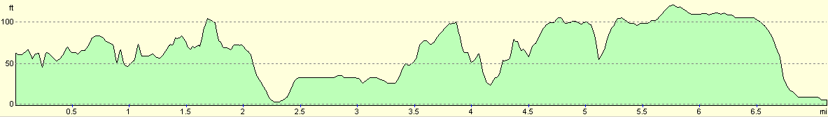
For more information on profiles, ascents and descents, see this page
Transport
There are regular train services running between Dartford and Gravesend. There are also bus services running between the two towns, but it appears that you may have to change at the Bluewater Retail Park.
Disclaimer
Please note that I take no responsibility for anything that may happen when following these directions. If you intend to follow this route, then please use the relevant maps and check the route out before you go out. As always when walking, use common sense and you should be fine.
If you find any information on any of these routes that is inaccurate, or you wish to add anything, then please email me.
All images on this site are © of the author. Any reproduction, retransmissions, or republication of all or part of any document found on this site is expressly prohibited, unless the author has explicitly granted its prior written consent to so reproduce, retransmit, or republish the material. All other rights reserved.
Although this site includes links providing convenient direct access to other Internet sites, I do not endorse, approve, certify or make warranties or representations as to the accuracy of the information on these sites.
And finally, enjoy your walking!
Nearby walks
| # | Title | Walk length (miles) |
|---|---|---|
| 123 | Mile End to Dartford | 15.0 |
| 176 | Gravesend to Rochester | 17.2 |
| 280 | Chalkwell to Stanford-le-Hope | 16.8 |
|
|

|