Walk #177: Bridgnorth to Broadstone
 |
 |
|
General Data
| Date Walked | 19/01/2002 |
| County | Shropshire |
| Start Location | Bridgnorth Station |
| End Location | Broadstone |
| Start time | 10.25 |
| End time | 17.10 |
| Distance | 15.5 miles |
| Description | This was a lovely walk that took in Brown Clee Hill, the highest point in Shropshire. The first part of it consisted of road walking, and the latter part was over muddy footpaths. |
| Pack | I used my Craghoppers 70-litre rucksack on this walk, and although I did not have a tent or Trangia with me I had my sleeping bag and spare clothes, making it a medium-weight pack. |
| Condition | Unfortunately I had not yet recovered from the illness that I had had on the previous walk the week before, which meant that I felt fairly weak. Despite this I managed to complete this walk with few problems, although I found the ascent up to the top of Brown Clee Hill more tiring than I ordinarily would have. I have no new blisters, (thanks to my having strapped my toes up well before I set off), and although I have a little redness on my shoulders they feel fine too. |
| Weather | The weather today started off fairly bright, with not much cloud in the sky. Unfortunately shortly after I set off it started to spit with rain. This did not last long, and the rest of the day consisted of sunshine and cloud. The wind was quite strong, although this was mostly noticeable on top of Brown Clee Hill where I got chilly quite quickly. Aside from that it was not too cold today, although I had to keep my hat and gloves on for most of the walk. |
| OS map | Landranger number 138 (Kidderminster & Wyre Forest) |
 |
 |
|
Map of the walk
Maps courtesy of Google Maps. Route for indicative purposes only, and may have been plotted after the walk. Please let me have comments on what you think of this new format. For a detailed table of timings for this walk, please see the table file.
 |
 |
|
Notes
This was yet another highly enjoyable walk, and because I reached the top of Brown Clee Hill it means that I have ticked off yet another county top off my list. Unfortunately it is not yet attached to the rest of my Land's End to John O'Groats walk, but to do this I only have to complete the day's walk between Wolverhampton and Bridgnorth, which I intend to do soon.
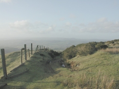
Unfortunately the first part of the walk involved more road walking than I would have liked, but that was probably just as well as the footpaths were generally a morass of squelchy, clingy mud which made walking difficult and reduced the enjoyment considerably.
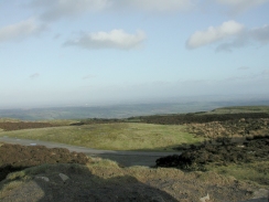
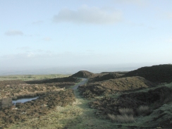
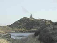
I could see the masts on top of Brown Clee Hill for most of the journey, and as they got close the ascent looked even steeper. The area around the summit was dominated not only by the two transmitter masts but also by the old mine workings that were present everywhere. I climbed up to the Trig Point, which was on top of what seemed to be an old spoil heap, and the views from it were amazing in nearly all directions.
I made a very late start to this walk due to the friend who dropped me off getting me there late, which meant that I was worried about being able to get off Brown Clee Hill and to some accommodation in time. I had not arranged any accommodation before starting the walk (although I had collected some phone numbers), so I had to ring around in the afternoon to find a bed for the night. Fortunately I fell on my feet and the B&B is great (although more expensive than I normally allow myself), and the evening meal was superb, a starter of salmon being followed by a superb stuffed chicken. Because of the late start I finished the walk in twilight, which made finding my way across the fields far more difficult than would ordinarily be the case, the muddy ground not helping matters either.
The summit of Crown Clee Hill is now covered with masts, but was once covered by Abdon Burf, which was an oval enclosure encompassing somewhere between 20 and 30 acres, with walls 65 feet wide at their base. The wind was very strong on the summit, so I left my pack beside the steps at the bottom of the little ascent to the Trig Point before climbing up to take the obligatory photographs. The weather was not ideal so I did not get a very long view (the distance was very hazy), but Titterstone Clee Hill was visible to the south and the Long Mynd above Church Stretton to the west. By the time I had finished taking the photographs I realised that it was later than I had expected, so I hurried on down off the hill.
Apparently this B&B is on an official Lands End to John O'Groats route for cyclists, so the landlady gets cyclists in all the time. It is also on the Shropshire Way, which must mean that she gets walkers in as well.
I stopped off for lunch at a pub in Drayton Priors, which was extremely nice and rustic inside and featured the most spartan and simplistic outside lavatory that I have seen for a long time.
Directions
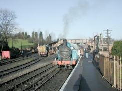
This walk starts off at the Severn Valley Railway Station in Bridgnorth. Leave the station and take some steps to the right of the footbridge that lead down to a road. Turn right along this road and then almost immediately right again, to head down the B4555.
After about a hundred yards turn right once more to take the B4363 Oldury Road. This heads southwestwards, passing under the railway line and then over the A458 road. Shortly after the A458 is crossed the little village of Oldbury is reached. Pass the church and take the first road to the right, Manor Farm Lane, that heads westwards for a short distance before turn into head southwestwards to end at a T-junction with another road.
A footpath heads off directly opposite this junction. Take this footpath as it descends so meet the B4364 road by a bridge over Mor Brook. Turn left and follow the B4364 over the brook, and then take a road that leads off to the right. Follow this road as it starts to climb uphill as it heads westwards. At the top of the hill it descends into a little valley and then climbs up the other side to a farm at Criddon. It then slowly ascends to a road junction beside a phone box at Lightwood.
Continue straight on as the road passes to the left of a wooded area before it eventually ends at a T-junction near Middleton Baggot. At this junction turn left and descend down into a valley before ascending up again into the little village of Middleton Priors. In Middleton Priors turn right down Brown Clee Road which descends to Rea Bridge which carries the road over a stream. The road then becomes Station Road as it ascends past an industrial estate and into the village of Ditton Priors.
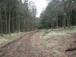
When the road gets near to the church in Ditton Priors turn left down South Road past the Howard Arms Inn. South Road twists round a little, but when it becomes Oakwood Road turn right to head southwestwards up Bent Lane, which despite its name is relatively straight. At the T-junction at the end of this road turn left and pass a phone box to head south eastwards. About seven hundred metres from the junction is a lay-by where cars can park and, opposite it, is the start of a forest walk that leads up the hill.
Take the stile on the right that leads over a hedge and to the start of the forest walk. The initial part of the climb is clear, with a nice winding track to follow. Shortly this joins a forestry track for a short distance, before heading off to the right once more to climb steadily uphill along a muddy track. When another track (this time grassed over) is reached the path heads straight uphill towards some ruined mine buildings. The path then becomes slightly harder to see on the ground, but as long as you head uphill you should reach a road on the summit plateau of Brown Clee Hill. The path meets the road beside a little lake which is another remnant of the mine workings. Turn left down the road and follow it as it winds around to the right towards the ariels. The steps up to the trig point are to the left of the road about fifty yards before the ariel complex is reached.
Descend southwestwards from the trig Point down an obvious path through the spoil heaps from the mine. This path then meets a grassy track, which descends northwestwards down the western flank of Brown Clee Hill to meet a road.
Turn right and follow the road as it almost immediately swings around to the left to head south-northwestwards for a short distance past a phone box until it ends at a T-junction. Turn left at this junction and follow the road as it turns to the right. After a couple of hundred metres a road junction is met to the right. Take this road as it heads northwards past Upper Earnstrey Park. The road then turns to the left and passes New Earnstrey Park.
Shortly after New Earnstrey Park a road leads off to the left. Follow this road for a couple of hundred metres until a driveway comes in from the right. Turn right down this driveway and follow it past Earnstrey Hall. The driveway becomes a track and soon after the hall it passes though a gate and becomes a footpath. Continue on southwestwards for a hundred metres until the top of a slope is reached. From here follow the 'Shropshire Way' sings as they lead off along the top of the slope though a wooded area. The path then descends the slope and then heads northwestwards across fields for a kilometre past Birchen coppice until a road is met at Holdgate.
I went straight across the road and attempted to follow a footpath that heads northwestwards towards Trow Brook. This was a very hard route to do across muddy fields in the rapidly fading daylight, so it would be best to follow the Shropshire Way instead. This heads off to the right along the road to a church. It then heads northeastwards across fields to Trow Brook which can then be crossed to meet Rowe Lane. Rowe Cottage is about two hundred metres to the left down the lane.
Distances
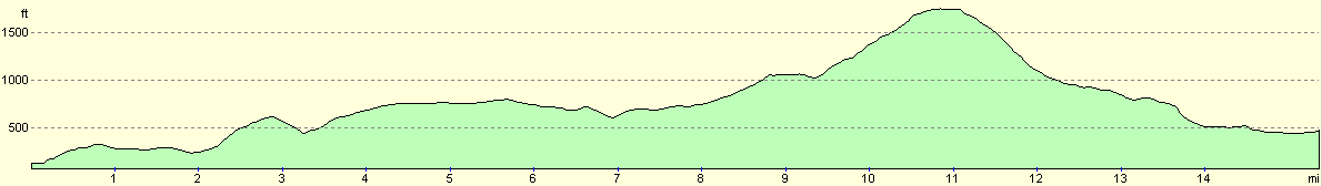
| From | To | Distance (m) | Ascent (ft) | Descent (ft) |
|---|---|---|---|---|
| Bridgnorth Station | Ditton Priors | 7.8 | 1165 | 554 |
| Ditton Priors | Brown Clee Hill | 3.2 | 1096 | 85 |
| Brown Clee Hill | Broadstone | 4.5 | 85 | 1352 |
This makes a total distance of 15.5 miles, with 2346 feet of ascent and 1991 feet of descent.
For more information on profiles, ascents and descents, see this page
Accommodation
I stayed at Rowe Cottage, Rowe Lane, Stanton Long, Much Wenlock, Shropshire, TF13 6LR. Telephone: 01584 841 286. This was an excellent (although pricey) B&B which makes excellent meals - my evening meal in particular was lovely. My room had a wooden four-poster bed in it and the whole building was superb. This was the best B&B that I have stayed in for a long time, and I thoroughly recommend it.
Disclaimer
Please note that I take no responsibility for anything that may happen when following these directions. If you intend to follow this route, then please use the relevant maps and check the route out before you go out. As always when walking, use common sense and you should be fine.
If you find any information on any of these routes that is inaccurate, or you wish to add anything, then please email me.
All images on this site are © of the author. Any reproduction, retransmissions, or republication of all or part of any document found on this site is expressly prohibited, unless the author has explicitly granted its prior written consent to so reproduce, retransmit, or republish the material. All other rights reserved.
Although this site includes links providing convenient direct access to other Internet sites, I do not endorse, approve, certify or make warranties or representations as to the accuracy of the information on these sites.
And finally, enjoy your walking!
Nearby walks
| # | Title | Walk length (miles) |
|---|---|---|
| 178 | Broadstone to Church Stretton | 8.1 |
|
|

|