Walk #175: Spalding to Peterborough
 |
 |
|
General Data
| Date Walked | 05/01/2002 |
| County | Lincolnshire, Cambridgeshire |
| Start Location | Spalding Station |
| End Location | Peterborough station |
| Start time | 08.45 |
| End time | 16.00 |
| Distance | 19.5 miles |
| Description | This was a surprisingly enjoyable walk, the highlight of which was finding the remains of the abbey and the beautiful and intriguing three-way bridge at Crowland. It was a mixture of riverside footpath and road walking which was hard on the feet in the post-snow mud but was rewarding nonetheless. |
| Pack | I carried a 30-litre daysack containing Psion 5, spare base layers and fleeces, a mug and a pot of self-heating coffee. |
| Condition | I am relatively okay after this walk, the largest problem being a painful blister on the fourth toe of my left foot. Apart from that my shoulders are fine, which is a relief as my right one had been hurting after the last walk. My legs are also fine, and I did not run out of energy at all during the walk. Since I was using my old pair of Saloman boots my feet suffered from blisters but my feet did not ache. |
| Weather | Today started off fairly foggy, and this spoiled any views that initially may have been available. Very slowly the fog began to lift, initially to be replaced by a slight haze in the distance. Once the fog had lifted it could be seen that it was an overcast day, with thick cloud above threatening rain. Fortunately this never materialised, and later in the day a few small patches of blue sky even became visible. There was very little wind, and the temperature was warm compared to the previous few days of sub-zero temperatures, so I managed to keep warm all day. |
| OS map | Landranger number 131 (Boston & Spalding) and Landranger number 142 (Peterborough, Market Deeping & Chatteris) |
 |
 |
|
Map of the walk
Maps courtesy of Google Maps. Route for indicative purposes only, and may have been plotted after the walk. Please let me have comments on what you think of this new format. For a detailed table of timings for this walk, please see the table file.
 |
Notes
This was an excellent way to start the year's walking, with a long route which I found surprisingly interesting considering it consisted of a great deal of road walking in the Fens.
The first part of the walk followed the River Welland as it headed south towards Crowland. The river looked quite nice in the fog, although the usual expansive views that you get in the Fens were denied me. The Welland is a man-made river, the original rivers in the area being rerouted as part of the drainage of the Fens. This explains why so many of the rivers are so straight and broad.
After leaving the river at Four Mile Bar bridge I walked for a short distance to Brotherhouse Bar, beside a main road, where I found a strange inscribed standing stone. The inscriptions were very illegible due to growth on the stone, but the letters I could see looked very runic and not a bit like any Latin-based alphabet. When I got home I had a look on the Internet, and I found a webpage with another picture of the stone taken in 1995 and a footnote that it may be a Celtic Standing Stone. Unfortunately it does not give any more details, so I have no idea what may (or may not) be written on it. Although he stone itself looked old, the base of the stone looked fairly modern, so it may well have been moved to its present location from elsewhere. It is marked in Gothic script on a 1:25,000 map as 'St Guthlac's Cross'. Further research says that it is the only remaining stone from a set that marked the bounds of Crowland Abbey. This seems like a much more reasonable explanation.
Crowland was a real surprise. As I approached the town I could see the main church in the distance. It looked fairly ugly, with an unusual low, squat and wide tower rising above the rooftops. I walked right past it and went past the front of it before I saw the reason; the remains of a large abbey beside the present-day church. The front of this was fairly unusual as it had many statues in it; most statues on cathedrals and abbeys were removed during Cromwell's reign after the civil war. A local told me that the present impressive Abbey remains are only one-eighth the size of the original abbey, and that at one time it was the second-biggest abbey in Britain, behind Glastonbury in Somerset. A sign showed that the Nave of the abbey was built in 1405 A.D., was 144 feet long and the roof fell in during 1688. Another showed that the South Aisle was 12 feet wide and was taken down in 1743 and that the Choir was built in 1281 and was 90 feet long.
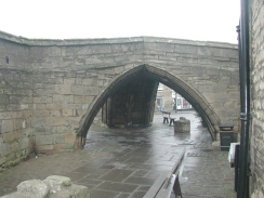
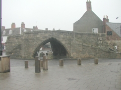
The second treat was a short distance away, in the form of a magnificent three-way bridge standing in the middle of the street. It is called Trinity Bridge, and I have never seen a bridge like this before, with three separate arches meeting up in the middle making a triangular bridge. What was even more unusual was that this was in the middle of a street and the bridge was over nothing. It turns out that originally Crowland was a place where the Welland divided into two streams, and the bridge therefore allowed people to get from one side of the rivers to any of the others. When the Fens were drained the rivers were diverted and wide roads built over them, leaving the bridge high and dry in the middle of the street.
I stopped off for a quick pint at the George and Angel Inn in Crowland, which is right beside the three-way bridge. I had a pint of Bombadier that was so smooth that it hardly touched the sides as it went down. I chatted to a man in there that enquired about my walking. It turns out that I had walked past his house earlier, and he was a very keen stock-car racer.
The walk through Peterborough was fairly boring, and it was a shame that a walk that had been so nice had to finish in that way. Despite this it was still fairly enjoyable, and only my fatigue made it seem longer than it really was.
When I got home and measured this walk I was pleasantly pleased to find that it was twenty-one miles long, as I was expecting it to be about eighteen. The distance measured matched well with the time that I spent on the walk, which is a very good sign, as I did not stop much on this walk. This walk sets me up well to do two others; to walk north to Boston and then onto Skegness; and eastwards to Long Sutton and Sutton Bridge.
Directions
This walk starts off at the station in Spalding. Turn right and join the A151 road south for about a hundred metres until it turns sharply to the right. Continue along the A151 after the turn and then take the first road to the left, St Thomas's Road. This leads in a southeasterly direction through the town. After a short distance the road turns to head in a southerly direction until it ends at another road.
At this road turn left and then almost immediately turn right to head south along the western bank of the River Welland, passing an old railway bridge over the river on the way. When a junction is reached with a road going over the river by a bridge, turn left and cross the bridge. On the other side turn right to start heading south down the B1173 Cowbit Road.
A couple of hundred metres down the B1173 a footpath leads off to the right along a track. Take this footpath as it heads over a stream. Almost immediately there is a junction in the path; one continues southwestwards following the river banking, the one I followed goes due south along a track called New River Drove. Just under a kilometer later the track becomes much more rough and the going slightly harder, and this continues until the track rises up to meet the A16(T) road.
Cross the A16(T) and continue south along a track on the other side for a couple of hundred metres. Shortly after you pass under some electricity cables a footpath leads off to the right along another track, heading towards the river banking. Take this path to the riverbank.
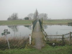
Climb up onto the bank and turn left, to head south along the eastern flood bank of the River Welland. Continue along the bank for a little over three and a half miles, until a footbridge over the river is reached at Four Mile Bar. At the footbridge turn left and heads south-eastwards along a track to meet a road at Brotherhouse Bar. My initial plan had been to walk all the way to Crowland along the flood banks of the River Welland and then the New River, but it was not clear on the map whether the footpaths on top of the two rivers were actually connected; if they were not then I was faced with a long walk back into Crowland. For this reason I chose the road walk described here.
At Brotherhouse Bar turn right to follow a minor road called Wash Bank. Do not join the A1073 which lies seductively nearby; this is too busy to be of any real use. Continue along the minor road as it follows a stream to the right as far as Cloot House. Here the road turns to the left and takes on a southerly heading for about a mile until it reaches Little Lodge Farm, becoming Cloot Drove in the process. From Little Lodge Farm it turns to the right to head southwestwards for a little under a kilometre before turning to the left to head south once more. It continues in a southerly direction for about a kilometre and a half until it reaches the B1166 Postland Road on the northern outskirts of Crowland.
Cross the B1166 and continue south down a road that lies opposite. When this ends at a T-junction turn right and head down Church Lane past the church and abbey. When the road bends around to the left past the front of the church turn right down East Street to meet the B1040. Turn left and follow the B1040 to the centre of the village where many roads meet. Prominent to one side of the area is the Trinity Bridge, a strange but lovely three-way bridge. At the Bridge take West Street that leads off to the west until it ends at a T-junction with West Bank road. Turn left down this road and follow it until a sharp left-hand bend in the road.
Continue along the road past the bend and take the first road that leads off to the right, called Crease Drove. This road continues below some flood banking for a short distance before turning to the left to head for a kilometre down to a farm at TF 230 090. Continue past the farm and cross a field, heading towards some obvious buildings to the southwest. When a stream is met immediately to the north of the buildings cross it by a small bridge and head down a track to Kennulph's Farm.
When the buildings at Kennulph's Farm are reached the way into a large yard is blocked by a simple barrier. Continue past this barrier and head through the yard to meet a rough track that heads south-south-westwards through the fields. A couple of hundred metres down this track take a footpath that heads off to the right to the south of a drainage channel. This path crosses a large channel by means of a bridge before ending at a road immediately to the south of Earldey Grange.
Turn left to head south-southeastwards down the road. When a rough road is met, turn right and follow it westwards for just under a mile until it ends at The Willows. Turn left down another road, Willow Road, which heads arrow-straight for two kilometres until it meets the B1143 road immediately to the north of Newborough.
Cross the B1143 and head southwards down Gunton's Road into the little village of Newborough. Pass the church and follow the road for four kilometres. For the majority of this time it is heading in a dead-straight line southwards, a bend to the left just south of Norwood Farm announces the approach of Peterborough.
The road from Newborough becomes Newborough Road before it eventually ends at the A47(T). Cross the road and head over a little bank and descend to meet an old section of road, which is now a rough track. Head south down this road for a short distance until a large earth bank blocks it. Climb over this bank and descend down to Welland Road opposite a large industrial building.
Turn right down Welland Road and follow it as it climbs up to go over the A15 dual carriageway. Continue along it as it heads southwestwards for a little over a kilometre until it ends at a junction with Dogsthorpe Road. At the junction turn left and follow Dogsthorpe Road as it heads south for 700 metres through the city. When this road meets another road junction turn right to head southwestwards through the city along Dogsthorpe Road until this one ends at yet another junction.
At this junction turn left and head south through the city down Lincoln Road. When the road bends sharply to the right to go westwards towards a roundabout continue straight on. When the road ends at a T-junction turn right to head westwards up Westgate. The railway station is a short distance ahead across the A15 road, and is clearly signposted.
Distances
| From | To | Distance (m) | Ascent (ft) | Descent (ft) |
|---|---|---|---|---|
| Spalding Station | Crowland | 9.6 | 7 | 16 |
| Crowland | Newborough | 4.8 | 10 | 7 |
| Newborough | Peterborough Station | 5.1 | 43 | 23 |
This makes a total distance of 19.5 miles, with 60 feet of ascent and 46 feet of descent.
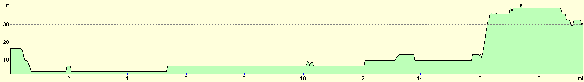
For more information on profiles, ascents and descents, see this page
Transport
Regular train services run between Peterborough and Spalding, so this is probably the best way of getting home. Crowland has busses running roughly every hour to Peterborough, and there are some services between Newborough and Peterborough.
Disclaimer
Please note that I take no responsibility for anything that may happen when following these directions. If you intend to follow this route, then please use the relevant maps and check the route out before you go out. As always when walking, use common sense and you should be fine.
If you find any information on any of these routes that is inaccurate, or you wish to add anything, then please email me.
All images on this site are © of the author. Any reproduction, retransmissions, or republication of all or part of any document found on this site is expressly prohibited, unless the author has explicitly granted its prior written consent to so reproduce, retransmit, or republish the material. All other rights reserved.
Although this site includes links providing convenient direct access to other Internet sites, I do not endorse, approve, certify or make warranties or representations as to the accuracy of the information on these sites.
And finally, enjoy your walking!
Nearby walks
| # | Title | Walk length (miles) |
|---|---|---|
| 55 | Peterborough to Whittlesey | 8.6 |
| 56 | Peterborough to Stamford | 16.5 |
| 71 | March to Peterborough | 20.3 |
|
|

|