Walk #285: Stone to Cliffe
 |
 |
|
General Data
| Date Walked | 03/12/2002 |
| County | Kent |
| Start Location | Stone (Kent) |
| End Location | Cliffe |
| Start time | 08.05 |
| End time | 13.24 |
| Distance | 13.6 miles |
| Description | This walk comprised of a long and dreary walk along a road, which was followed by a much more interesting walk along the Saxon Shore Way past three forts. |
| Pack | I did not wear a pack due to the trouble that I had with my shoulder a few days ago. Instead I worse Sam's large bum bag, which meant that I was not bearing any weight on my shoulder. In the bag I carried some fruit and spare batteries. |
| Condition | I feel perfectly fine after this walk, and I have no problems to report. My shoulder only ached a couple of times on this walk, and I can now move it fully without experiencing any pain. |
| Weather | The weather today was overcast, with little of the sun to be seen. There was a few minutes worth of light drizzle in the air in the early afternoon, but this was the only sign of any rain. There was not much wind to be seen, and all in all the day could have been (and indeed was forecast to be) much worse. |
| OS map | Landranger number 178 (Thames Estuary, Rochester & Southend-on-Sea) |
 |
 |
|
 |
 |
|
Map of the walk
Maps courtesy of Google Maps. Route for indicative purposes only, and may have been plotted after the walk. Please let me have comments on what you think of this new format. For a detailed table of timings for this walk, please see the table file.
 |
Notes
The first part of this walk to Gravesend was a boring plod along roads, as he footpaths nearer the river had been shut due to work on the Channel Tunnel Rail Link. AT times I got to see these works from a high vantage point and the road traversed a hill, and in one place the road had been diverted to one side so that they could build a bridge on the original alignment. These works all looked interesting and very, very, expensive, so I found it hard to resist stopping occasionally to look over and see if I could see what they were doing.
On a previous visit to Gravesend I had found St George's Church in the middle of the town. Outside the church is a statue dedicated to Pocahontas, who was the daughter of an Indian Chief who is supposedly buried in the vault underneath the chancel in the church. Ever since the Disney film of the same name I had associated Pocahontas with the film, so I was surprised to find out that she was really existed. She was the first North American Indian Christian, and she died in the town on her return to Virginia after having visited King James I on 21st March 1617. It is an amazing story, but as I have never seen the Disney film I cannot say whether the film details any of this or not.
The walk eastwards out of Gravesend had a fairly awful industrial beginning to it as the Saxon Shore Way headed between large industrial buildings and down unkempt roads. Several of the roads and paths were flooded with foul-smelling water that was over ankle deep, so I ended up getting both of my feet wet when the water lapped over the top of my boots. Once out of Gravesend the situation improved however, and the walks soon became far better. Unfortunately after this mud ruled the day, with thick mud all over the embankment where it had been churned up by an large-wheeled vehicle for a long distance towards Shornemead Fort.
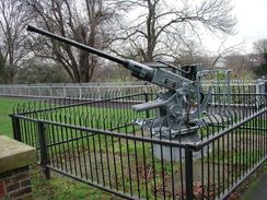
Today I passed three more Thames forts; the first, at Gravesend, was the remains of the New Tavern Fort in Gravesend, which was built in 1780 to 1818. This fort linked with Tilbury Fort on the north bank of the river in order to produce a deadly crossfire across the river. Originally the fort had fifteen cannon to counter French invasion, but in 1840 these were replaced with cannon, which could move on traversing platforms. These soon became outdated as they would not be very effective against French ironclads, so from 1868 to 1872 the fort was remodelled for ten heavy rifled muzzle loading guns, and in 1904 for two breech loaders against German invasion. The fort then fell out of disuse, and became a public garden in 1932. The fort is quite nice, and it has many information boards and old weapons to be inspected which I found highly interesting.
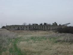
The second fort that I came across was the remaining section of wall from Shornemead Fort . The structure has mostly been obliterated, leaving just the outwards-facing wall as the main visible structure above ground. I actually found this fort the most interesting out of the three, as it was possible to explore the remaining ruins or a long time in comparative safety. I would love to be able to explore some of the underground passages that still exist, but I am too much of a coward to do that sort of thing on my own.
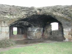
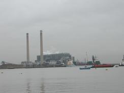
The third fort was Cliffe Fort, and of the three forts this one is the most complete, and to my untrained eye it looks like a copy of its partner fort, Coalhouse Fort, on the other side of the river. Unfortunately although it is the most complete fort it is also the most inaccessible, as all the windows are boarded up and the ports for the guns are boarded up. There are dangerous structure signs everywhere, but I really hope that they do not demolish this fort. The fort is in the grounds of a working quarry, and it is a sort of green oasis amidst the hustle and bustle of the quarry, with trees and ivy growing all around it. This made it very hard to take photographs of the front of the fort, and I wish that I could have explored it further. Elsewhere there were other buildings and structures that looked as though they could have been military in origin, but I have absolutely no idea what any of them were, especially as some of them had been razed to the ground, and only the floor slabs were remaining.
Directions
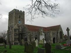
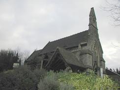
This walk starts off at a lay-by on the A226 road, to the east of Dartford at TQ 56431 74062. Head eastwards along this road as it climbs and falls to a roundabout with the B255 road beside an amazingly attractive McDonalds restaurant. Cross over the roundabout and continue on uphill, passing a lovely little stone church on the right. Continue on as the road rises and falls as it heads through Swanscombe and Northfleet before ending at a T-junction in Gravesend. At the junction turn right and then almost immediately to the left, before continuing on to Gravesend Station.
Continue on past Gravesend Station until the road ends. At the end of the road turn left to head down the High Street until you meet the shorefront of the River Thames.
Turn right and head eastwards along the shore, following the Saxon Shore Way. The initial part of this section is through an industrial area where navigation is fairly complex, but fortunately the Saxon Shore Way signs are frequent and clear. Eventually the riverside is reached again by some large dockside cranes and piers. Climb up some steps over a concrete wall and join the grassed riverside flood banking.
Head eastwards along the flood banking as it passes the Shorne Marshes. After about a mile and a half a large stone structure becomes visible immediately inland of the flood banking. This is the Shornemead Fort, and was quite an imposing structure.
The flood banking continues on beside the river, crossing a stile near a lighthouse. The flood banking starts to head northeastwards across Higham Saltings until Higham Creek is reached. Here it is important to make sure that you are on the lower flood bank on the left rather than the higher one on the right, as the lower one bends away to the left to head north along the creek whilst the larger bank heads inland. Fairly soon Cliffe Fort is reached, and the path continues on around the fort and past some jetties. As it goes around the fort the path curves to the right to start heading eastwards inland along the southern bank of Cliffe Creek.
At the end of Cliffe Creek I meant to follow the Saxon Shore Way eastwards into Cliffe, but I went wrong and walked southeastwards along a track and footpath, which ended at the end of a surfaced road by a quarry. To get back on course I then took another track that headed off to the left from the end of the road , which slowly became narrower and muddier as it curved around and eventually ended in the little village of Cliffe. In Cliffe I turned to the right and headed south for a short distance through the village past a pub until I reached the church.
Distances
| From | To | Distance (m) | Ascent (ft) | Descent (ft) |
|---|---|---|---|---|
| Stone | Gravesend Station | 5.4 | 505 | 545 |
| Gravesend Station | Cliffe | 8.2 | 148 | 174 |
This makes a total distance of 13.6 miles, with 653 feet of ascent and 719 feet of descent.
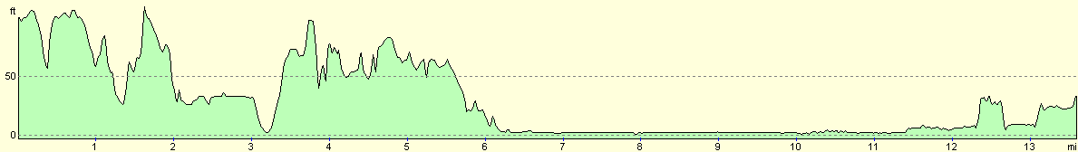
For more information on profiles, ascents and descents, see this page
Accommodation
We stayed at the Woodmans Wood Caravan and Camping Park, Rochester Road, Bridgewood, Chatham, Kent ME5 9SB. They can be contacted on 01634 867685. This is a nice site with some good facilities, which cost us twelve pounds per night. The toilets were clean, and the showers were nice and hot and, wonder of wonders, in a room that was actually heated!
Disclaimer
Please note that I take no responsibility for anything that may happen when following these directions. If you intend to follow this route, then please use the relevant maps and check the route out before you go out. As always when walking, use common sense and you should be fine.
If you find any information on any of these routes that is inaccurate, or you wish to add anything, then please email me.
All images on this site are © of the author. Any reproduction, retransmissions, or republication of all or part of any document found on this site is expressly prohibited, unless the author has explicitly granted its prior written consent to so reproduce, retransmit, or republish the material. All other rights reserved.
Although this site includes links providing convenient direct access to other Internet sites, I do not endorse, approve, certify or make warranties or representations as to the accuracy of the information on these sites.
And finally, enjoy your walking!
This walk was mentioned in the following routes:
| My walk around the coastline of Britain |
Nearby walks
| # | Title | Walk length (miles) |
|---|---|---|
| 123 | Mile End to Dartford | 15.0 |
| 161 | Gravesend to Dartford | 7.2 |
| 176 | Gravesend to Rochester | 17.2 |
|
|

|