Walk #284: Greenwich to Stone
 |
 |
|
General Data
| Date Walked | 02/12/2002 |
| County | London, Kent |
| Start Location | Greenwich (Cutty Sark) |
| End Location | Stone (Kent) |
| Start time | 07.40 |
| End time | 14.40 |
| Distance | 19.0 miles |
| Description | This was quite a nice walk, heading eastwards beside the southern bank of the Thames following the extension to the Thames Path National Trail. |
| Pack | I did not wear a pack due to the trouble that I had with my shoulder yesterday. Instead I worse Sam's large bum bag, which meant that I was not bearing any weight on my shoulder. In the bag I carried some fruit and spare batteries. |
| Condition | I must have felt reasonably okay at the end of this walk as I felt that I could easily have walked further if I had needed to. My shoulder did not give me any trouble today, which was probably due to the fact that I did not wear a rucksack, and the only slight problems that I had was a slight soreness on my feet from all the road walking and a sore path on the underside of my right arm. |
| Weather | The forecast for today was for heavy showers, so I was pleasantly surprised when it did not rain at all during the walk. There was a thick cloud layer overhead, and once or twice the sun attempted to break through. All in all it was a fairly nice day for a walk. |
| OS map | Landranger number 177 (East London, Billericay & Gravesend) |
 |
 |
|
 |
 |
|
Map of the walk
Maps courtesy of Google Maps. Route for indicative purposes only, and may have been plotted after the walk. Please let me have comments on what you think of this new format. For a detailed table of timings for this walk, please see the table file.
Notes
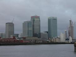
The walk along the southern bank of the Thames has been much more enjoyable than the walk along the northern one. On the northern bank I had to make big diversions inland to avoid refineries, docks etcetera. The walk along the southern bank was much better, with paths available all the way as far as the River Darent with only small inland diversions needed.
Traditionally the Thames Path ended (or started) at the Thames Barrier, so I was expecting to have to devise my own route eastwards from there. Fortunately when I got there I found signs stating 'Thames Path Extension', which went as far as Crawford Ness. I therefore followed this, and except for a mile or so to the east of the barrier it followed the river all the way to Crawford Ness. I must admit that Crawford Ness is a very strange place for a national trail to finish; it is very literally in the middle of nowhere with a long walk needed down the River Darent to get to Dartford. As I was walking towards Crawford Ness I noticed that on the map there is a tidal barrage, and I started hoping that there may be a way across the river at the barrage. Unfortunately there was not, and so I had to walk down the river. This is an ideal place for a bridge to be built, which would allow the trail to be extended across the river and down into Swanscombe and then Gravesend with very little difficulty. Unfortunately I really cannot see this happening, so it looks as though the Thames Path will have to be ending in the middle of nowhere.
This evening we had arranged to meet up with an old friend of mine, Neil, who lives in Purley on South London. Therefore at the end of the walk we jumped into Mervan and drove around the M25 to Purley, which we reached far too early. We therefore spent a few hours chatting to a friend of his in his house before he came back and the serious beer drinking and curry eating began. It was very nice to see Neil for the first time in ages, and we talked for ages, catching up with the latest gossip. This means that in the morning we will have to drive back around the M25 to where today's walk ended at Stone, which means that we will have to have an early start to try to avoid the traffic.
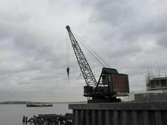
At Crossness I came across the large sewage works that serves the majority of South London. This was actually a nice (if slightly smelly in places) walk, and there are lots of information boards about the works, including the highly disturbing fact that in 1857 over 25,000 Londoners died of Cholera. As a result of this a massive programme to clean up the Thames was started, and in 1865 Joseph Bazalgette, the engineer for the Metropolitan Board of Works, built the Crossness pumping station. Initially all waste from South London was pumped here (there is a similar site at Beckton for North London) and discharged into the river, but later on a treatment plant was built. Until 1998 the waste product from the treatment plant was pumped into boats that then dumped it into the sea, but since then a sludge-powered generator was built, which burns the sludge and provides power to the rest of the water treatment plant. This is housed in an absolutely superb building which I fell in love with, and has a grace that belies its rather smelly purpose. The plant processes 3,400 tonnes of sewage sludge every day, which is the equivalent of 1,000 toilets flushing every second! As a result of all this work the Thames is now the cleanest Metropolitan river in the world, which is a vast change from the situation 150 years ago.
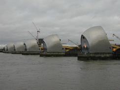
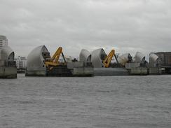
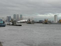
The Thames Barrier was a highlight of my day, as it is one of my favourite structures. Sam met me near it and we walked down to it together, and I explained to her how it all worked. It really is structural engineering on a monumental scale, and on a previous walk years before I was lucky enough to see all the gates close and block off the river.
As I was walking down the River Darent I met a man who told me that the path on the other side of the river was closed due to work on the Channel Tunnel Rail Link. This did not really surprise me, so I decided to change my route and walk into Dartford and then out again eastwards along roads. This has slightly shortened my route, but I am still well over my 5,500-mile target. When I got into Dartford I realised that I could walk further and that there was not anywhere convenient for Sam to pick me up, so I decided to walk along the road. After a couple of miles as I neared the little village of Stone Sam met me and we started the drive up to Purley.
Directions
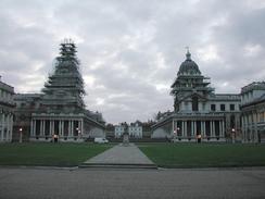
The first part of this walk follows the Thames Path eastwards along the southern bank of the river, starting at the Cutty Sark in Greenwich as far as the Thames Barrier. The path is very well signposted, and when it splits around North Greenwich I followed the route that cuts across the peninsular rather than following it around the Millennium Dome; I only realised that the latter route existed when I reached the other bank of the river.
I had been expecting to have to create my own route eastwards from the Thames Barrier, where the Thames Path ended. However when I reached the barrier I discovered that there was a new path, called the Thames Path Extension that follows the south bank of the river as far as Crayford Ness. This path is also very well signposted, and aside from the first section between the Thames Barrier and the Woolwich Ferry it follows the riverbank for the vast majority of the way, and navigation is easy. Follow it all the way to Crayford Ness.
At Crayford Ness turn to the right and follow the western bank of the River Darent southwards for a couple of miles. Just before a bridge carrying a railway line over the river is reached the footpath joins a small track that eventually becomes a road as it passes under the railway line before ending at the A206 road.
Turn left down the A206 as it passes over the river and under the railway line once more before ending at a roundabout. At the roundabout turn right down the A2026 road for a little over a kilometre until another roundabout is reached just before the railway station in Dartford is reached. At this roundabout turn right to pass under the railway line and on the other side follow the road around to the left before ending at another roundabout. Turn right at this roundabout and follow the A226 road uphill out of the town. At another roundabout continue on along the A226 as it passes over the wide A282(T) road and continues on eastwards. This walk ends a short distance further up this road in Stone, near the junction with the B3228 road.
Distances
| From | To | Distance (m) | Ascent (ft) | Descent (ft) |
|---|---|---|---|---|
| Greenwich | Woolwich Ferry | 4.5 | 52 | 52 |
| Woolwich Ferry | Crawford Ness | 9.0 | 144 | 148 |
| Crawford Ness | Stone | 5.5 | 190 | 95 |
This makes a total distance of 19.0 miles, with 386 feet of ascent and 295 feet of descent.
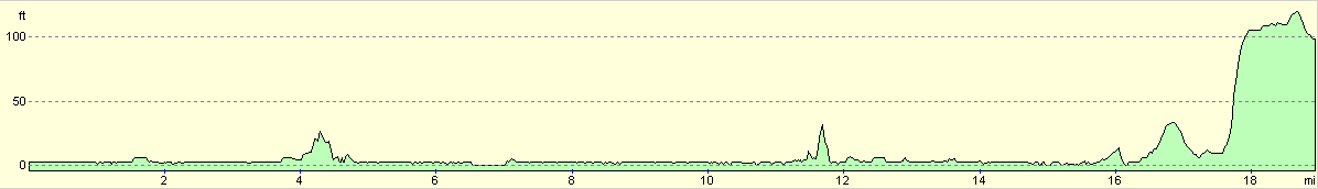
For more information on profiles, ascents and descents, see this page
Accommodation
We stayed outside a friend's house in Purley, which is a very long drive from where we finished the walk.
Disclaimer
Please note that I take no responsibility for anything that may happen when following these directions. If you intend to follow this route, then please use the relevant maps and check the route out before you go out. As always when walking, use common sense and you should be fine.
If you find any information on any of these routes that is inaccurate, or you wish to add anything, then please email me.
All images on this site are © of the author. Any reproduction, retransmissions, or republication of all or part of any document found on this site is expressly prohibited, unless the author has explicitly granted its prior written consent to so reproduce, retransmit, or republish the material. All other rights reserved.
Although this site includes links providing convenient direct access to other Internet sites, I do not endorse, approve, certify or make warranties or representations as to the accuracy of the information on these sites.
And finally, enjoy your walking!
This walk was mentioned in the following routes:
| My walk around the coastline of Britain |
Nearby walks
| # | Title | Walk length (miles) |
|---|---|---|
| 50 | Paddington to Mile End | 8.3 |
| 51 | Mile End to Enfield Lock | 12.7 |
| 123 | Mile End to Dartford | 15.0 |
|
|

|