Walk #583: A circular walk from Tissington to Longcliffe and Parsley Hay
 |
 |
|
General Data
| Date Walked | 28/12/2003 |
| County | Derbyshire |
| Start Location | Tissington Station car park |
| End Location | Tissington Station car park |
| Start time | 08.00 |
| End time | 15.12 |
| Distance | 21.9 miles |
| Description | This was a lovely walk, taking in parts of the Limestone Way, High Peak and Tissington Trails. |
| Pack | Today I carried my 30-litre Karrimor HotRock rucksack, which was filled with my waterproof leggings, water bottle, trainers and a couple of spare shirts, together with the usual assortment of odds and ends. |
| Condition | Aside from a couple of hot-spots on my feet I feel absolutely fine after this walk, which is a good sign after walking nearly twenty-two miles without a break. |
| Weather | The weather today was far better than it was yesterday; early on there was a little snow flurry, but this was soon followed by clear skies for the majority of the day. About half an hour before the end there was another snow flurry, but this ended before I got to the car. The worst thing about the weather was the wind, which was very blustery and annoying when I was exposed to its full force. |
| OS map | Outdoor Leisure number 24 (The Peak District - White Peak Area) |
 |
 |
|
 |
Map of the walk
Maps courtesy of Google Maps. Route for indicative purposes only, and may have been plotted after the walk. Please let me have comments on what you think of this new format. For a detailed table of timings for this walk, please see the table file.
Notes
I only planned this walk yesterday night, once I had finished the walk north from Hartington. A few days ago I realised that if I could complete around fifty miles by the end of the year then I would have walked 5,000 miles in 2003, a target too tempting to miss. After yesterday's walk I still had forty-two miles left to complete to do this, and so I decided to do a long walk today as the forecast was for good weather. I soon decided that the walk would start in Tissington and take the Limestone Way to Longcliffe, where I could join a couple of abandoned railway trackbeds through the heart of the Peak District back to Tissington.
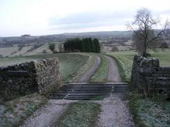
This meant that I would have to make an early start, and it was still dark when I arrived at the car park in Tissington. After paying £2.70 for the parking ticket I sat in the car listening to the radio for ten minutes until it got light enough to start the walk. It was quite cold outside and there was a heavy frost on the ground, but the low temperature helped all my senses feel more sensitive and alive. I started walking north up the Tissington trail until I reached the first overbridge, where I climbed up and joined the Limestone Way. I had walked this early in 2001, and it was nice to be back walking it again. A drop down to Bletch Brook was followed by a steep climb up to the pretty little village of Parwich, which was still slumbering and seemed deserted as I walked through, stopping to take some photographs of the church.
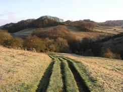
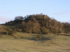
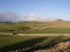
More fields and another climb took me to the village of Ballidon, where the village church is in a fairly spectacular location in the middle of a field, away from surrounding buildings. This too was worth a couple of photographs, and as I looked down at the church and the surrounding hills I thought that it must be a superb place to worship. Yet another hill took me to the B5056 road, and then onto a climb up Pasture Lane, with the prominent limestone outcrops of Black Rocks and Rainster Rocks visible a short distance to the north. The temperature was still low and there was some black ice on the roads, but I really enjoyed the stroll in the early morning light.
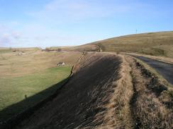
Another path took me to a road just to the north of Brassington, and here I left the Limestone Way and headed north along the road to join the High Peak Trail. This trail runs along the course of the old High Peak railway line, which was a very early railway, designed by Josiah Jessops and opened in 1825. It was a very unusual railway; built to connect the Cromford Canal in the east with the Peak Forest Canal in Whaley Bridge, it was a railway designed on canal principles. This meant that it had long near-level sections (suitable for the poor traction and power capabilities of early locomotives), with steep inclined planes powered by stationary steam engines, such as the one at Middleton Top. The line closed in the 1960's, and it was soon converted into this cycle path.
The walk along the High Peak Trail was exceedingly easy going (both navigationally and on the feet), and I enjoyed the stroll along it. Many cyclists overtook me as I walked, and strangely enough they were all going in the same direction as me - I did not encounter any going the other way! The path took me past the large Ballidon Quarry (which is still in use) and the Gotham Curve (which was one of the sharpest curves on the British Railway network), and then crossed the A5012 road at Newhaven Crossing. I passed an old disused quarry right beside the path, which had a crane that was slowly rusting away and becoming part of the environment once more, before passing under the A515 Ashbourne to Buxton Road by a tunnel, with engraved stones above the portals describing on one side the railway's initials, and on the other the name of the railway's engineer.
I soon reached the junction with the Tissington Trail just to the south of Parsley Hay, and as the wind was so chilling I decided not to walk the half-mile to Parsley Hay Station and back again, but to immediately head south. The Tissington Trail follows the course of the old Ashbourne to Buxton railway line, which closed in 1968 (about the same time as the High Peak line), and was also converted into a cycle path. The views from the line were very nice, but by this time I was starting to get quite tired and I had not yet had a rest. Because of this I had been making good time, but whenever I found a good place to stop I continued on due to the wind. At times this was blowing me from one side of the path to the other, particularly when I was on embankments exposed to the full fury of the wind. I did nip into the toilets at Hartington Station, but when I tries to sit down on the steps of the old signal box to eat my sandwiches the wind forced me to keep walking, and so I ate as I walked.
Towards the end of the walk grey clouds gathered overhead and it started to sleet, and then snow. Although this meant that I was colder it was only a light shower, and it certainly added to the atmosphere of the walk. The ground temperature was too high for the snow to settle, and I just enjoyed looking at the scenery as it slowly drifted down. By the time I reached the car I was fairly tired, although I felt very happy at having walked nearly twenty-two miles without taking a break, the longest walk that I have done without a break for some time.
Directions
This walk starts off at the Tissington Trail car park in the village of Tissington, a few miles to the north of Ashbourne. The car park is situated actually on the trail, so head northwards under an overbridge and onwards for a little over a kilometre, until another overbridge is reached. Immediately before this overbridge a pathway leads off to the left, and when it reaches the top of the bridge turn right and cross it. For the next four and a half miles the route follows the Limestone Way northeastwards. Cross a cattle grid and follow the track as it curves to the left for a few yards, and then turn right to head downhill to the southeast of Shaw's Farm to Bletch Brook. Cross the brook and on the other side climb steeply uphill along an obvious path. At the top of the hill the path starts descending down the other side and angles to the right to meet a road near the church in the village of Parwich.
When the road is met in Parwich turn to the right and walk a few yards until the road ends at a T-junction by a pond; then turn left and immediately right to head past the church. When the road forks take the right-hand fork ands walk northwards along the road for a few yards until a junction is met. At this junction another footpath heads off to the right, heading northeastwards to the corner of a filed before turning right to climb steeply up a hill. At the top of the hill Highway Lane is met; here turn right and descend southwards along it for a couple of hundred yards. When a road comes in from the right turn left down another footpath that east-southeastwards across fields before ending at a road to the south of Ballidon. Turn left along this road for a few yards and then turn right up a track that passes the solitary Ballidon Church before climbing uphill to the east.
As it nears the top of the hill the path joins a track, and this can be followed as it curves down the steep hill before ending at the B5056 road to the south of White Edge. Cross the B5056 and then head uphill to the east along Pasture Lane, which passes immediately to the south of Rainster Rocks. When Pasture Lane curves sharply to the right after a kilometre continue straight on along a track uphill for another few hundred yards. When the lane ends take a footpath that heads off to the northeast over a hill; the path heads slightly to the east of a set of overhead power cables, and both times I have walked this route I have hot the road too far south! This does not matter, however, and when you hit the road turn left to head northwards along it. After a couple of hundred yards at Peak Quarry Farm I took a footpath off to the right that headed behind the farm and past an electricity substation before reaching the High peak Trail at Longcliffe (alternatively instead of taking the footpath behind the farm you could just continue along the road and when you reach an overbridge take some steps up to the right onto the High Peak Trail).
The next stretch of the walk is exceptionally easy; just turn left and follow the High Peak Trail as it heads in a roughly northwesterly direction for a little under eight miles; the route is easy to follow as it passes through Minninglow, Gotham and crosses the A5012 at Newhaven Crossing. The trail goes through a tunnel under the A515 and soon reaches a junction with the Tissington Trail, a couple of hundred metres to the south of Parsley Hay. At the junction turn sharply to the left, to head south along the Tissington Trail. Again navigation is simple; simply stay on the trail as it heads south for nine miles, passing Hartington Station before eventually reaching the car park at Tissington, where this walk ends.
Distances
| From | To | Distance (m) | Ascent (ft) | Descent (ft) |
|---|---|---|---|---|
| Tissington | Longcliffe | 5.0 | 1016 | 715 |
| Longcliffe | Parsley Hay | 7.9 | 558 | 518 |
| Parsley Hay | Tissington | 9.0 | 827 | 1168 |
This makes a total distance of 21.9 miles, with 2401 feet of ascent and 2401 feet of descent.
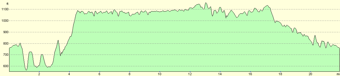
For more information on profiles, ascents and descents, see this page
Disclaimer
Please note that I take no responsibility for anything that may happen when following these directions. If you intend to follow this route, then please use the relevant maps and check the route out before you go out. As always when walking, use common sense and you should be fine.
If you find any information on any of these routes that is inaccurate, or you wish to add anything, then please email me.
All images on this site are © of the author. Any reproduction, retransmissions, or republication of all or part of any document found on this site is expressly prohibited, unless the author has explicitly granted its prior written consent to so reproduce, retransmit, or republish the material. All other rights reserved.
Although this site includes links providing convenient direct access to other Internet sites, I do not endorse, approve, certify or make warranties or representations as to the accuracy of the information on these sites.
And finally, enjoy your walking!
Nearby walks
| # | Title | Walk length (miles) |
|---|---|---|
| 11 | Stanton Moor | 2.9 |
| 12 | Darley Dale, Stanton Moor and Rowsley | 8.7 |
| 14 | Friden, Long Dale and Gratton Dale | 7.8 |
|
|

|