Walk #582: A circular walk from Hartington to Hollinsclough and Earl Sterndale
 |
 |
|
General Data
| Date Walked | 27/12/2003 |
| County | Derbyshire, Staffordshire |
| Start Location | Hartington |
| End Location | Hartington |
| Start time | 08.30 |
| End time | 14.09 |
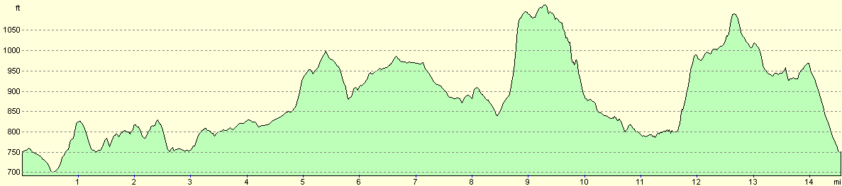
| Distance | 14.8 miles |
| Description | This was an entertaining walk through part of the western side of the Peak District. |
| Pack | Today I carried my 30-litre Karrimor HotRock rucksack, which was filled with my waterproof leggings, water bottle and a couple of spare shirts, together with the usual assortment of odds and ends. |
| Condition | I feel absolutely fine after this walk, and I could easily have walked further if I had needed to. The blisters that I had have fortunately got down during the week since my last walk, and gave me no trouble. |
| Weather | The weather was very mixed today; it initially started sunny but with a brisk wind, but this soon changed to a combination of sleet, rain and even snow when I was higher up on the hillsides. |
| OS map | Outdoor Leisure number 24 (The Peak District - White Peak Area) |
 |
 |
|
Map of the walk
Maps courtesy of Google Maps. Route for indicative purposes only, and may have been plotted after the walk. Please let me have comments on what you think of this new format. For a detailed table of timings for this walk, please see the table file.
Notes
When I set off from home this morning I was unsure about where I was going to walk; I was tempted to do a walk south from the Cat and Fiddle pub, but as I drove north of Ashbourne along the A515 I could see a low cloud layer over the hills to the west, and so instead I decided to do a walk from Hartington, which was my back-up plan. I arrived at Hartington in plenty of time as it was a much shorter drive, and so before I got my kit on I went to the small newsagents in the village to get some snacks to supplement the ham sandwiches (leftovers from Christmas).
Initially I drove through Hartington to the car park a short distance out of the village; this was marked on the map but when I got out of the car I discovered that it cost three pounds fifty for an entire day's parking, which I thought was rather an extortionate price. The ticket machine did not take two pound coins either, so I could not pay and I drove the hundred yards back into the village. In the centre of the village there were a few parking space jammed in between two roads, and as I could see no signs stating that I could not park there I decided that it would have to do.
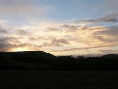
There was a glorious red sky as I set off southwestwards along the main road out of Hartington, and I was surprised that the sky should be so red despite it having been light for half an hour - the shortest day was less than a week ago, and this probably explains it. Once I left the road I crossed some fields to the farm at Scaldersitch, where there were some ponies just outside the farmyard. As I leant on the gate checking my map for the route some dogs came yapping up to me, and these were rapidly followed up by a lady, who showed me the correct route through the fields. Apparently they have lots of trouble with Duke of Edinburgh award groups who take the wrong route, and I had a nice chat to her about her two Highland cow bulls who were in the field. I find it quite amusing that after having spent the summer walking in the Highlands past many herds of Highland cattle, I should see two of them essentially in my backyard!
Just past Brund I met up with a couple from Sutton Coldfield who were up for the day, and I ended up walking with them to Longnor. It felt weird to be walking with other people, and although they were walking at a slightly slower pace than me I did not mind this, as I was intent on having a relaxing walk anyway. They had set off from Hartington at the same time as me, and we had taken different routes to get to Brund. I met them as they were pulling on their waterproofs as it had started to sleet, but I already had my coat on and did not have my waterproof trousers with me (these have been mislaid since the end of my coastal walk). I really enjoyed my chat with them, and they certainly made the miles seem to go quicker.
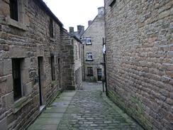
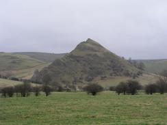
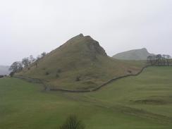
Longnor was a superb little village, and I enjoyed looking at the unusual double-decker church and narrow cobbled streets (which reminded me of Squeez-e-belly alley in Port Isaac, Cornwall) before moving on out of the village, passing the fire station and the adjacent indoor climbing wall. I said goodbye to the couple before setting off along the road, and once I was near the bottom of the hill I could see them continuing on along the higher road. The route from Longnor to Hollinsclough was along roads, but this we more than compensated for by the brilliant views of the precipitous hills of Hollins, Chrome and Parkhouse, which seemed to jut out of the surrounding scenery. Between Hollins and Chrome Hills I could see a faint dusting of snow laying on the higher ground, a sight I had not seen for some time. It was a marvellous view, and seemed to epitomise what the Peak District means for me.
From Longnor I took a footpath that followed a track to a little bridge over the River Dove (from now on the walk would roughly follow the river and the Derbyshire / Staffordshire border), and I soon met up with the couple once again. We walked past the superb Chrome and Parkhouse Hills, and as we climbed the steep ascent up to Earl Sterndale I frequently turned back to look at the views of the craggy Parkhouse Hill, which has an exceedingly steep face that looks as though someone has removed two-thirds of the hill. We soon got to Earl Sterndale and the amusingly-named 'Quiet Woman Inn', where once again I parted company with the couples as I was going to follow the road and footpaths south to Pilsbury Castle. I passed through Crowdecote and ignored the temptation of nipping into the pub, and made my way across an occasionally boggy path to Pilsbury Castle.
Pilsbury Castle is quite an imposing location on a hillside above the River Dove. There are no remaining signs of the castle, which was of a motte and bailey type, and was probably built shortly after the Norman Conquest in 1066. Most castles of this period were initially built in wood and later strengthened with stone; this castle probably only remained in use for a few decades and was therefore never rebuilt in stone. The reef limestone knoll on which it is built is a lovely spot, and it was a shame that it was snowing when I got here, as it would have been an ideal spot to sit down and absorb the view for a few minutes. The snow was lashing down, however, so I continued on uphill along the footpath.
Another footpath took me south along the eastern bank of the River Dove; the views from this footpath back to the north were superb, although the grey skies ominously looked filled with more snow. The wind was blowing the snow right into me, and I was glad when I descended down the last stretch of footpath and emerged onto a road for the last half-mile into Hartington. I stopped to have a quick look at the pretty church in the village before descending down to my car. As I arrived and started taking my boots off the sun came out, and it was hard to imagine that it had been snowing half an hour before! This was a lovely walk, and I would like to incorporate parts of it into other walks in the future if possible.
Directions
This walk starts off from the car park right in the centre of the village of Hartington. Leave the car park and turn right to head south out of the village along Mill Lane; after fifty yards the road passes a car park on the right before curving to reach Hartington Bridge over the River Dove. Cross the bridge and follow the road up the hill on the western side; shortly after a small right-hand bend join a footpath that heads off to the right, crossing a field before meeting another road. Cross this road and take another footpath that follows a track down to the farm at Scaldersitch. Walk through the farmyard, and then head for a few yards down a track to a little stream. Once across the stream turn right off the track and head up to a stile in the top-right hand corner of the field. In the next field head northwestwards with the field boundary to the right, until a stile leads out onto a road.
Once on the road turn left for a few yards past a farm before taking another footpath that leads off to the right. This footpath heads northwestwards past the farm at Lowend, where it joins a track. A short distance north of Lowend the footpath heads off to the left away from the track and towards a small triangular patch of trees before curving to head northwestwards and meeting a road. Follow this road north-northwestwards through Brund, and when it curves to the right continue either on the road or on a footpath that heads off to the left, before rejoining the road just above Brund Mill. Cross the road and take another footpath (directly opposite a road junction) that heads north-northwestwards across fields, with the River Manifold to the left. Once the river comes close to the left the path climbs off the floodplain and onto the hillside, and then heads past the farms at Ridge End and Lower Boothlow.
Between Lower Boothlow and Upper Boothlow the path splits; either will do, but I took the lower path that headed down onto the floodplain near a bridge over the river and then headed northwards, finally climbing up to join a road just to the east of Longnor. At the road turn left and after a few yards when Longnor is entered turn right up a minor road, which leads uphill and passes the church before ending at a T-junction. Here turn right uphill along another road past the fire station, and then turn left down another road that heads steeply downhill. At the bottom of the hill turn to the right and join another road that heads northwestwards past Moss Carr and ends in Hollinscough. Once in the village turn right near the phone box down another road that heads eastwards; at a right-hand bend turn left along a footpath that runs along a track to the northeast. When a track junction is reached turn right to head eastwards along a footpath.
This footpath soon reaches a ford and footbridge over the River Dove. Cross the bridge and carry on along the track for a short distance until it ends at a road. Continue straight on eastwards along this road until it ends at a T-junction with another road near Glutton Bridge. Turn left to head north along this new road for a few hundred yards, and then turn right along a footpath that climbs steeply up the flank of Hitter Hill. At the top the footpath curves to the right to head eastwards and slowly descends to end at a road beside the 'Quiet Woman Inn' in the village of Earl Sterndale. Once at the road turn right and walk southeastwards out of the village. Just outside the village the road forks; take the right-hand fork that passes a pond and Abbotside Farm before curving around a large hill and ending at a T-junction with another road in Crowdecote.
At this junction turn right to head downhill along another road. Pass the pub on the left, and then turn left down a track that heads southeastwards. When the track ends continue straight on along a footpath that heads across fields towards the motte and baileys of Pillsbury Castle. The footpath climbs uphill past the castle and then heads southeastwards above Pilsbury, where it turns to head eastwards. Soon after the bend it crosses a road and heads eastwards for a few hundred yards until it meets a footpath crossroads by a stone wall. Turn right and head uphill to the south along this new footpath, and continue along this path as it heads south above the River Dove. Near bank Top Farm it crosses a track and continues on along the side of the hill before ending at a road. At the road turn right and follow it as it heads south for about a kilometre, passing the church in Hartington and ending at a T-junction in the village. At the junction turn right along another road for a few yards to the car park in the centre of the village, where this walk ends.
Distances
| From | To | Distance (m) | Ascent (ft) | Descent (ft) |
|---|---|---|---|---|
| Hartington | Hollinsclough | 7.4 | 748 | 531 |
| Hollinsclough | Hartington | 7.4 | 889 | 1106 |
This makes a total distance of 14.8 miles, with 1637 feet of ascent and 1637 feet of descent.
For more information on profiles, ascents and descents, see this page
Disclaimer
Please note that I take no responsibility for anything that may happen when following these directions. If you intend to follow this route, then please use the relevant maps and check the route out before you go out. As always when walking, use common sense and you should be fine.
If you find any information on any of these routes that is inaccurate, or you wish to add anything, then please email me.
All images on this site are © of the author. Any reproduction, retransmissions, or republication of all or part of any document found on this site is expressly prohibited, unless the author has explicitly granted its prior written consent to so reproduce, retransmit, or republish the material. All other rights reserved.
Although this site includes links providing convenient direct access to other Internet sites, I do not endorse, approve, certify or make warranties or representations as to the accuracy of the information on these sites.
And finally, enjoy your walking!
Nearby walks
| # | Title | Walk length (miles) |
|---|---|---|
| 1 | Shining Tor and Cat's Tor from the Cat and Fiddle pub | 7.2 |
| 14 | Friden, Long Dale and Gratton Dale | 7.8 |
| 17 | Alport circular | 11.8 |
|
|

|