Walk #581: Burton-on-Trent to Derby
 |
 |
|
General Data
| Date Walked | 18/12/2003 |
| County | Staffordshire, Derbyshire |
| Start Location | Burton-on-Trent railway station |
| End Location | Derby railway station |
| Start time | 08.23 |
| End time | 14.20 |
| Distance | 16.3 miles |
| Description | This was a nice stroll, following the Trent and Mersey Canal for most of the way before turning off down the course of the old Derby Canal into the centre of Derby. |
| Pack | Today I carried my 30-litre Karrimor HotRock rucksack, which was filled with my waterproof leggings, water bottle and a couple of spare shirts, together with the usual assortment of odds and ends. |
| Condition | For the first time in ages I had big trouble with my feet today; on my last walk a couple of days ago I got two blisters, which I burst and bound in tape in time for today's walk. Unfortunately this did not really work, and I was starting to hobble as I approached the end of the walk. Aside from this I felt fine, and I was not tired in any way. |
| Weather | Today was a very sunny day, with scarcely any cloud in the sky. The night had been quite cold and there was a heavy frost everywhere, and this remained throughout the day as the temperature did not seem to rise much above freezing at all during the day. All in all it was a lovely day for a walk. |
| OS map | Landranger number 128 (Derby & Burton upon Trent) |
 |
 |
|
 |
Map of the walk
Maps courtesy of Google Maps. Route for indicative purposes only, and may have been plotted after the walk. Please let me have comments on what you think of this new format. For a detailed table of timings for this walk, please see the table file.
Notes
This was a walk that was not a very high priority on my todo list, but the forecast had been for a bright and frost day, so I decided that another canal side walk would be in order. I had also been feeling slightly strange that my walks had been through many towns and cities, but I had yet to walk through my hometown of Derby. Whilst it was still dark I set off from home and drove the twenty-minute drive into Burton-on-Trent. As I was planning to get the train back from Derby to Burton I decided to park as near to the station as possible, and I was fortunate enough to get the last space in the station car park, which cost me two pounds to park in for the night. I nipped into the adjacent shop to buy a couple of bars of chocolate before putting my rucksack on and heading through the centre of Burton to the canal.
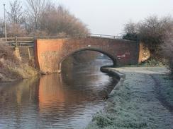
Burton is famous for its breweries, and the tall towers and silos were prominent on the skyline as I headed towards the canal. It was years since I had last been in Burton, and I enjoyed the sights and sounds of the town as I strolled through it. It had been a very cold night, and despite the blue, clear skies it was till cold, and people were busy scraping ice off their windscreens as I made my way towards Shobnall Marina and the Trent and Mersey Canal. I joined the towpath and started the long walk northwards along it, the cold temperatures making the going easy as the mud formed by the recent heavy rains had frozen solid. There a thick sheen of frost on all the vegetation, and this gave the landscape a sort of winter wonderland look as I walked along. A narrow boat passed me heading south, its prow acting as an icebreaker of the layer of ice that lay on the surface of the water. It was quite a magical walk, and as usual the canal provided a very green and traffic-free route through the town.
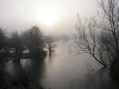
I soon found myself heading out of Burton, and although the scenery was quite magical it was spoilt somewhat by the close proximity of the A38(T), which runs right by the canal for quite a long way. When I reached the aqueduct over the River Dove I was greeted with a nice foggy and frosty scene, which unfortunately did not photograph very well. I soon found myself leaving the A38(T) behind and headed through Willington, and then passing the two power stations that were demolished last year, leaving only five massive cooling towers standing sentinel over the deserted and cleared site. Workmen were busy repairing the rail bridge that carries the mainline to Derby over the canal, and I watched them work for a few minutes before heading on down the canal to Stenson. In a couple of places the canal had been dredged and the mud places on the side of the canal; I was surprised to see clamshells three or four inches long in the mud, as it had never occurred to me that they grew in canals!
By the time that I reached Stenson, I realised that I had plenty of time in which to finish the walk and so I nipped into the Stenson Bubble, a pub by the marina. I was born in a house a few yards up the road in Stenson, and when I was a child my dad used to take me down to the lock to see boats go through, so being back in Stenson made me reminisce slightly. I went into the pub and slowly sank down a pint, and for some reason I felt quite depressed. I was unsure about why this was, but it could have been due to the fact that my feet were hurting me. I finished the pint and then walked up the road to Bank House, the house where I was born. I did not go up the driveway, but stood looking at the green roof and hoards of memories came flooding back to me. Unusually this did not awaken me from my depression, so I walked back down the road to the lock and had a quick chat to the lock keeper, who remembered my parents, before heading off back along the canal.
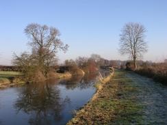
On the next three miles along the canal to Swarkestone my feet really started hurting; I had bound the two blisters that I got on the walk a couple of days ago, but it appears that it had not worked and my feet were far from being prefect. I passed a simple memorial to Lynn Siddons, a local schoolgirl who gut murdered by the canal in 1978; a case still remembered locally, before passing Barrow-on-Trent. My brother, grandma and grandpa live in this village, and my auntie lives on a house on a hill near the canal, so the stretch to Swarkestone was very much familiar to me. At Swarkestone Lock there is a canal junction; the Trent and Mersey continues on eastwards to the junction with the River Trent in Shardlow, whilst off to the left the course of the Derby Canal heads north into the city centre. The Derby Canal was built in 1796 and was shut in 1964, being filled in shortly afterwards. The only remaining watered stretch of the canal is a hundred yards from the junction with the Trent and Mersey, the stretch being filled with boats.
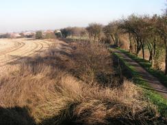
I passed a bridge and joined the towpath of the Derby Canal; although the canal is dewatered and overgrown (and a mile further on is filled in) the towpath still exists in the form of a cycle path into the centre of the city. There are plans for the Derby Canal to be reopened as far as Pride Park (to the east of the city), although I did not see many signs of this as I walked along. The walk north along the towpath was not very memorable after the first mile as it passed behind the long industrial estate at Ascot Drive, and I was quite glad when I reached London Road. Here I went wrong; since my Ordnance Survey map was published in 1999 a new road has been built north into Pride Park, and instead of following the course of the canal I headed north along the new road. I was not devastated about this despite the fact that it took a mile off the walk, as by this time my feet were, if not agony, hurting intensely, and I was extremely glad when I passed the Derby County Football Club stadium and made my way to the entrance to Derby Station. What is now Pride Park used to be a mass of railway sidings, and it is hard to believe this today - only the street names having vague railway-related themes.
Directions
This walk starts off at Burton-upon-Trent railway station. Leave the station via the car park and turn left to walk northwestwards up the road. Just before the church is reached turn left down the B5121 road for a few hundred yards until it reaches a roundabout. At the roundabout turn right and head northwestwards down the B5017 road past another roundabout; the road heads uphill over a bridge before descending past Shobnall Marina and reaching the canal. At the canal turn right and join the canal towpath.
The directions for the next few miles are simple; just follow the canal towpath as it heads northeastwards out of Burton-upon-Trent to and through Willington. Near Findern the canal turns to head eastwards, passing through Stenson and eventually reaching Swarkestone Lock. Here turn left and join the cycle path that heads northwards; for the first few yards the Derby Canal is in water, but it soon becomes a dewatered channel, and later disappears totally. The path is easy to follow, as there are frequent cycle path signs for the centre of Derby.
Once you reach London Road in Derby you could turn right to continue along the course of the canal. I, however, walked straight on along the new road, the A6, into Pride Park. When you reach the second roundabout near some gasholders turn left to head northwestwards down another road, and then as you approach a bridge over the railway line turn left down another road that leads to some enclosed steps that lead up to Derby station footbridge, where this walk ends.
Distances
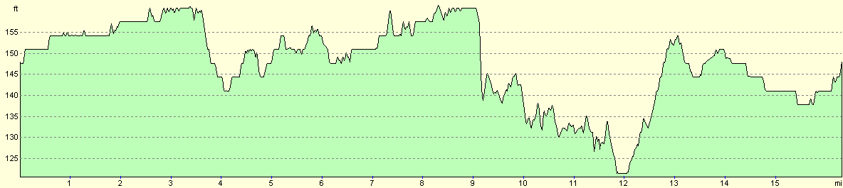
| From | To | Distance (m) | Ascent (ft) | Descent (ft) |
|---|---|---|---|---|
| Burton-on-Trent | Willington | 6.1 | 52 | 49 |
| Willington | Swarkestone | 5.3 | 85 | 108 |
| Swarkestone | Derby | 4.9 | 75 | 52 |
This makes a total distance of 16.3 miles, with 212 feet of ascent and 209 feet of descent.
For more information on profiles, ascents and descents, see this page
Transport
There are regular, direct train services from Derby to Burton-upon-Trent; a single ticket for my journey cost me £3.90.
Disclaimer
Please note that I take no responsibility for anything that may happen when following these directions. If you intend to follow this route, then please use the relevant maps and check the route out before you go out. As always when walking, use common sense and you should be fine.
If you find any information on any of these routes that is inaccurate, or you wish to add anything, then please email me.
All images on this site are © of the author. Any reproduction, retransmissions, or republication of all or part of any document found on this site is expressly prohibited, unless the author has explicitly granted its prior written consent to so reproduce, retransmit, or republish the material. All other rights reserved.
Although this site includes links providing convenient direct access to other Internet sites, I do not endorse, approve, certify or make warranties or representations as to the accuracy of the information on these sites.
And finally, enjoy your walking!
Nearby walks
| # | Title | Walk length (miles) |
|---|---|---|
| 64 | Long Eaton to Willington | 14.0 |
| 68 | Willington to Doveridge | 12.6 |
| 613 | Derby to Matlock | 20.2 |
|
|

|