Walk #12: Darley Dale, Stanton Moor and Rowsley
General Data
| Date Walked | 06/03/1999 |
| County | Derbyshire |
| Start Location | Darley Dale |
| End Location | Darley Dale |
| Start time | 13.00 |
| End time | 16.15 |
| Distance | 8.7 miles |
| Description | This walked involved a steep climb up onto Stanton Moor, then along to the Nine Ladies Stone Circle and (for one day only) its associated snowman!. The along to the road and down to Rowsley via Stanton Woodhouse. Finally followed the railway back to Darley Dale. |
| Pack | Today's pack was full. I carried my sleeping bag, tent, spare clothes, food etc. It is about as heavy as it will be for a long-distance walk. |
| Condition | I feel okay after this walk. My legs were a bit stiff. |
| Weather | It was raining until I reached the moor, when it started snowing heavily. Rain came again once I got back to a road. It cleared up and stopped raining from Rowsley to Darley. |
| OS map | Outdoor Leisure number 24 (The Peak District - White Peak Area) |
Map of the walk
Maps courtesy of Google Maps. Route for indicative purposes only, and may have been plotted after the walk. Please let me have comments on what you think of this new format. For a detailed table of timings for this walk, please see the table file.
Notes
This was an enjoyable stroll from the Derwent Valley up to Stanton Moor, then back via Rowsley. The weather was far from ideal, with fairly heavy rain and snow for most of the day. A solitary snowman sat glumly in the middle of the Nine Ladies Stone Circle.
Stanton Moor is one of my favourite places in the Peak District, and one that I do not get to visit often enough. There are many items of interest on the moor including four Bronze Age stone circles, the most famous of which is the Nine Ladies Stone Circle. This circle of small stones is hardly visible until you are on top of them, but what they lack in size they gain in ambiance - the surroundings are spectacular, with the low, scrubby trees that surround it giving it a sylvan feel. Nearby is the Earl Grey Tower, which was built to commemorate the 1832 reform act, and the Cork Stone, which has handholds that allow you to climb up to the top.
Directions
Start off in Darley Dale Station car park. There is ample parking in the surrounding area.
Walk down the B5075 towards Darley Bridge and Winster. There is a pavement on the right-hand side of the road. Cross the River Derwent at Darley bridge and follow the road until you shortly get to a junction signposted to the left for 'Stanton'. Take this road and follow it uphill past the Einhoven Lead Works. You then pass through the hamlet of Warrencarr and onto a junction with a road heading uphill to the left.
Follow this road uphill. The gradient slowly flattens out and you eventually reach a small inlet on the right which has a path going uphill from it. The inlet can be used to park 2 to 3 cars. Follow this path uphill and onto Stanton Moor. After a short while you reach a fence. Do not cross this fence but follow it around the moor until you reach a large stone tower. At the tower, cross the stile immediately to the west and head north across the moor for a short distance until you reach the Nine Ladies Stone Circle.
Continue along he path northwards over a stile and across a field to Lees Road. Follow the road downhill past a junction and a massive piece of stonework to the right. Shortly after this, there is a stile on the left which is beside Endcliffe Quarry.
Follow the path north=northeast down the hill to Stanton Woodhouse Farm. Follow the path to the right of the farmhouse which eventually becomes a tarmac track. Follow this track downhill all the way to Rowsley and the A6. At the A6 turn right and walk a few yards to a bridge over the River Derwent.
From the bridge follow the A6 and take a right turn into an industrial estate. Follow the road for a short distance southwards and go through a stile in a fence to the right to join a path. This path goes south through the old Rowsley Marshalling Yard, and everywhere there are traces of it's industrial past amid the undergrowth and trees. Eventually you will reach a roundabout. Continue straight on through the gate opposite and down a track leading to Rowsley South station.
If you so desire (and the trains are running) you may be able to take a steam train back to Darley Dale from here. Alternatively, walk across the car park southwards and take the footpath beside the railway line. This brings you after 3/4 of a mile to a road which you cross to regain the footpath on the opposite side, with a new housing estate to your left and the railway to the right. About 1/2 a mile later you reach Darley Dale Station once more.
Distances
| From | To | Distance (m) | Ascent (ft) | Descent (ft) |
|---|---|---|---|---|
| Darley Dale | A6 at Rowsley | 6.3 | 938 | 931 |
| A6 at Rowsley | Darley Dale | 2.4 | 59 | 66 |
This makes a total distance of 8.7 miles, with 997 feet of ascent and 997 feet of descent.
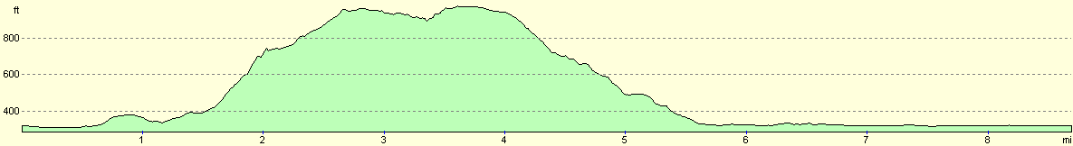
For more information on profiles, ascents and descents, see this page
Disclaimer
Please note that I take no responsibility for anything that may happen when following these directions. If you intend to follow this route, then please use the relevant maps and check the route out before you go out. As always when walking, use common sense and you should be fine.
If you find any information on any of these routes that is inaccurate, or you wish to add anything, then please email me.
All images on this site are © of the author. Any reproduction, retransmissions, or republication of all or part of any document found on this site is expressly prohibited, unless the author has explicitly granted its prior written consent to so reproduce, retransmit, or republish the material. All other rights reserved.
Although this site includes links providing convenient direct access to other Internet sites, I do not endorse, approve, certify or make warranties or representations as to the accuracy of the information on these sites.
And finally, enjoy your walking!
Nearby walks
| # | Title | Walk length (miles) |
|---|---|---|
| 2 | Waterbeach to Newmarket Road, Cambridge | 5.4 |
| 5 | A short walk around Waterbeach to Car Dyke | 3.0 |
| 6 | Waterbeach to Newmarket Road, Cambridge | 5.4 |
|
|

|