Walk #305: Tipner to Browndown
 |
 |
|
General Data
| Date Walked | 23/12/2002 |
| County | Hampshire |
| Start Location | Tipner |
| End Location | Browndown |
| Start time | 08.26 |
| End time | 15.40 |
| Distance | 18.9 miles |
| Description | This was a nice walk around Portsmouth Harbour, taking in Portchester Castle and Gosport on the way. |
| Pack | Today I carried my 30-litre Karrimor HotRock rucksack, which was filled with my packed lunch, waterproof leggings, water bottle and a couple of spare shirts, together with the usual assortment of odds and ends. |
| Condition | I am fairly fatigued after this walk, but have no other problems to report. |
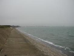
| Weather | There was no rain today, which was a relief as the weather forecast had been for rain. It was a very mild day for the time of year, and there was not much wind so I remained nice and warm. There was not much sing of the sun, and unfortunately by the time I reached Gosport there a slight mist over the sea so I could not see the Isle of Wight across the Solent. |
| OS map | Landranger number 196 (The Solent & The Isle of Wight, Southampton & Portsmouth) |
 |
 |
|
 |
 |
|
Map of the walk
Maps courtesy of Google Maps. Route for indicative purposes only, and may have been plotted after the walk. Please let me have comments on what you think of this new format. For a detailed table of timings for this walk, please see the table file.
 |
Notes
Today was a day of impressive structures - a castle, shipbuilding sheds and forts all vied for my attention.
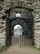
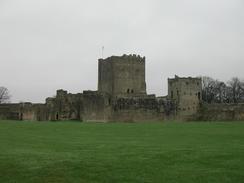
Portchester Castle impressed me massively. The first sight that I got of it was of the Keep from a few miles away, standing proud above the little peninsular on which it stands. As I reached it I realised that there was actually a great deal more than the Keep still standing - the castle had curtain walls all the way around it, and my route allowed me to cover two side of this wall. It was quite impressive in scale, and on the top of the wall the remains of castellatations could be seen, although they had been severely eroded. I walked trough a gateway and into the interior of the castle, where I could see that although ruinous it was one of the most complete ruins that I had yet seen on this trip, and I wanted to have a closer look around it. Unfortunately time would not allow this, so with regret I had to turn back and continue on my walk.
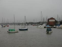
As I approached Portchester I was very impressed by the scale of the Vosper Thornycroft ship building sheds that are to the north of the town. The buildings are truly gigantic in size, and I wondered what activities could be going on inside them. I was surprised to find a small hut marked 'Vosper Thornycroft Arabic School' whilst I was walking; I suppose it makes sense to have such schools when trading with foreign countries, but the need had not really occurred to me before. From Gsport I could see over the mouth of Portsmouth Harbour to Portsmouth, and I could see many warships lined up in the Royal Navy Dockyard as well as some of the ships in the historic dockyard.
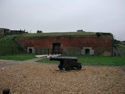
Stokes Bay was one of the places where the Mulberry Harbour sections were built in 1944. The western end of the Bay is now used by the military, I believe for Hovercraft testing. There was an information board showing some of the harbour sections being constructed, and I could not help but be impressed by the scale of the works. I passed many forts during the day, of which I got closest to the one at Gilkicker Point at the southeastern end of Stokes Bay. This was a fairly small fort compared to some that I have been to, but it was not open today so I could not have had a look around even if my timescale had allowed it.
Mike came to visit today, and his mum lives only forty-five minutes away. To celebrate Christmas we all went out to the pub inside the campsite this evening, although I was feeling very tired and did not want to get too drunk so I left at about nine. Just before midnight I heard Sam and Mike enter the van, and it was clear that they were both the worse for drink, which I found amusing the next morning when they had hangovers. Fortunately I could start the next day's walk from the site, so Sam did not have to move the van and she could allow herself time to recover before moving on. All in all it was an excellent evening, and it was great to see Mike once again.
Directions
This walk starts off at the Northern Road / Walker Road junction on the A3 in Tipner, to the north of Southampton. Walk northwards along the A3, which at this point is called Northern Road, to a roundabout. At the roundabout head straight on past the Avenue Hotel and down a path through an area of parkland that meets a cycle path running along the shore. Turn right and follow the cycle path along the shore.
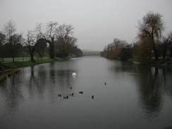
When a lake is reached on the right turn right and walk around the southern end of the lake, which is very narrow at this end. On the other side of the lake climb up some rough steps onto the top of a rampart, which is part of a defensive structure called Hilsea Lines. Follow the top of the ramparts as it heads eastwards with the lake to the left. When it ends descend some steps and walk to a dual carriageway main road by a footbridge. Turn left to head northwards along this road for a short distance until it meets a large roundabout under the start of the M27.
Pass around the roundabout and then turn left along a footpath that runs beside the A27. This footpath passes some IBM property and buildings before reaching a large roundabout that allows access to the IBM headquarters to the left. Continue straight on down the A27 until you reach the Paulsgrove roundabout on the A27. AT the roundabout the footpath descends to the right to pass under the road onto the right-hand side using a pedestrian subway. On the other side of the road turn left to walk back up to the roundabout at an approach road. Turn left to cross the approach road that allows access to the A27.
Walk past the Harbour Lights restaurant and bar and a Tesco Extra before the road heads under the M27. Continue on past the harbour of Port Solent. When Hamilton Road is met on the left turn left down it through an industrial area that includes some Vosper Thornycroft buildings. At the end of the road continue straight on down a footpath that leads along a seawall to Porchester Castle. Walk along the footpath around the castle's curtain wall and then join the King's Way walk, which heads for 44 miles from Portchester to Winchester. The path heads south along the seawall and foreshore to the south of Portchester before heading past a little quay. After the quay the path enters the Wicor Recreation Ground, and follow the path westwards from a car park across the recreation ground. When the path meets the shore once more follow the shore for a short distance until it meets a little surfaced track. Turn right up this track as it passes under some power lines and joins the end of a road. Follow this road as it heads northwards before ending at the A27 Portchester Road.
Turn left down the A27 until it passes under a large brick railway viaduct and ends at a roundabout. Pass under an arch of the viaduct and then turn left along a pavement that parallels the viaduct for about a hundred yards before turning to the left along a road that heads under the viaduct once more. Head along this road for about a hundred yards before turning to the left down a footpath that skirts the shoreline southwards before reaching some houses with built-in yacht berths below them. Here the path climbs up to the right join a naarrow dead-end road that leads out onto another footpath that runs beside the shore through a recreation ground. The path continues on as the railway line slowly approaches on the right before it eventually passes under an arch of the viaduct and meets the A32 road.
Turn left down the A32 and then turn left down Old Gosport Road past a little marina and then turn left down Lower Quay, which passes lots of little boating shops. Shortly after a big house turn right and then immediately turn left down Lower Quay footpath that heads beside a large brick wall on the left. At the end of this footpath a road is met, so turn left to meet the edge of the water. Follow a surfaced footpath southwards around the edge of the water. The path turns to the right to follow the bank of a stream inland and passes a bus depot before it ends at the A32 road.
Turn left down the A32 and follow it heads southeastwards for a coupe of kilometres until it reaches a junction immediately to the north of Fort Brockhurst. Turn left at this junction along Elson Road and follow it for a little under a kilometre to another roundabout. Turn right at this roundabout down St Thomas's Road until Grove Road leads off to the right. Follow Grove Road southwards until San Diego Road leads off to the left at a mini roundabout. Turn down this road, which soon becomes Mill Lane before it ends at the A32 once more.
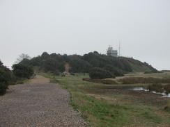
Turn left and follow the A32 as it heads eastwards until it reaches the bus station in Gosport. Turn left to meet the water's edge in Gosport immediately behind the bus station. Turn to the right and follow the Solent Way as it skirts the edge of the water, climbing over a wooden pedestrian bridge over a little area of water before ending at Haslar Road. Turn left along this road to head southwestwards down the road, crossing over a large bridge and passing the Haslar Hospital before it ends at a T-junction. Turn left down Fort Road and follow this road as it curves around passing a strange triangular monument and a couple of lakes on the left before a surfaced track called Military Road leads off to the left across a golf course down to Fort Gilkicker.
Pass behind the fort to get to the beach and then turn right to head northwestwards along the beach. Near the lifeboat station a surfaced promenade starts that can be followed beside Stokes Bay as a road joins the promenade. When the road turns sharply to the right beside a fort to head northwards to a roundabout. At the roundabout turn left down Browndown Road, crossing the River Alver before turning right to enter the Kingfisher Park caravan park, where this walk ends.
Distances
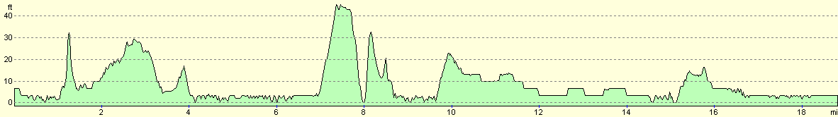
| From | To | Distance (m) | Ascent (ft) | Descent (ft) |
|---|---|---|---|---|
| Tipner | Portchester Castle | 4.9 | 115 | 118 |
| Portchester Castle | Gosport | 9.7 | 177 | 177 |
| Gosport | Blackdown | 4.3 | 49 | 46 |
This makes a total distance of 18.9 miles, with 341 feet of ascent and 341 feet of descent.
For more information on profiles, ascents and descents, see this page
Accommodation
We stayed at the Kingfisher Caravan Park, Browndown Road, Stokes Bay, Gosport, Hampshire PO13 9BG. They can be contacted on 023 9250 2611. This site was quite nice with some good facilities, although the grass between the pitches (which were all hard standing) was waterlogged, which they cannot really be blamed for. The showers were powerful and the toilet blocks warm, so all in all it was worth the eleven pounds that we paid to stay at the site.
Disclaimer
Please note that I take no responsibility for anything that may happen when following these directions. If you intend to follow this route, then please use the relevant maps and check the route out before you go out. As always when walking, use common sense and you should be fine.
If you find any information on any of these routes that is inaccurate, or you wish to add anything, then please email me.
All images on this site are © of the author. Any reproduction, retransmissions, or republication of all or part of any document found on this site is expressly prohibited, unless the author has explicitly granted its prior written consent to so reproduce, retransmit, or republish the material. All other rights reserved.
Although this site includes links providing convenient direct access to other Internet sites, I do not endorse, approve, certify or make warranties or representations as to the accuracy of the information on these sites.
And finally, enjoy your walking!
This walk was mentioned in the following routes:
| My walk around the coastline of Britain |
Nearby walks
| # | Title | Walk length (miles) |
|---|---|---|
| 303 | Chidham to Langstone | 16.0 |
| 304 | Langstone to Tipner | 16.8 |
| 306 | Browndown to Bursledon | 12.9 |
|
|

|