Walk #303: Chidham to Langstone
 |
 |
|
General Data
| Date Walked | 21/12/2002 |
| County | West Sussex, Hampshire |
| Start Location | Chidham |
| End Location | Langstone |
| Start time | 09.40 |
| End time | 15.48 |
| Distance | 16.0 miles |
| Description | This was an eventful day's walk, taking in the army range on Thorney Island in less than perfect weather. |
| Pack | Today I carried my 30-litre Karrimor HotRock rucksack, which was filled with my packed lunch, waterproof leggings, water bottle and a couple of spare shirts, together with the usual assortment of odds and ends. |
| Condition | I feel okay after today's walk, although I did struggle to get the distance completed before dark after such a late start. The worst problem is that my feet have suffered since they got wet, and the underside of both of them was aching by the end of the walk. |
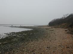
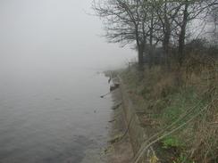
| Weather | The day started off cloudy, and not long after I set off fog rolled in, which rather spoilt the views that I should have been able to have. Towards the end of the walk it started to rain, and although I did not get massively wet it was a miserable end to a miserable day, with no signs of the sun ever making an appearance. The only positive thing about today is that it was quite mild, and I was quite comfortably warm all day, even when my legs and feet were wet. |
| OS map | Landranger number 197 (Chichester & The South Downs, Bognor Regis & Arundel) |
 |
 |
|
 |
Map of the walk
Maps courtesy of Google Maps. Route for indicative purposes only, and may have been plotted after the walk. Please let me have comments on what you think of this new format. For a detailed table of timings for this walk, please see the table file.
Notes
This was a very eventful day, and one which I hope that I do not have to repeat in a while. It started well, and we started up the van to drive the short distance to the start of the walk in good time. Unfortunately as soon as Sam started driving it was obvious that something was wrong, and she pulled the van up at the first possible occasion, which happened to be outside the church. I got out and had a look around, and the rear passenger side tyre was well and truly flat.
We got the jack and associated kit out, and I undid the spare tyre which is hung underneath the van. All this got me well and truly dirty, as the roadside where we had pulled up was muddy and dirty. Unfamiliarity with the van made the job harder, and next time we have to do this it would be a much quicker job. I loosened the wheel nuts and placed the jack under the van and started to jack it up. This was harder than I expected as the ratchet spanner that they provided was hard to turn as the van body got in the way, even after using an extension tube. Then, to make matters worse, the ratchet spanner stopped working when the jack was nearly fully up so it would not turn the jack either up and down.
I was faced with no choice but to ring for the AA, who cover the van. They came fairly promptly and we only had to wait about twenty-five minutes before the van turned up. The man used a trolley jack to lift the van up and oiled the ratchet spanner so that it would work (we unfortunately did not have any WD40 in the van or I would have tried this earlier). We eventually got on our way, and Sam eventually dropped me off a little after half past nine in the morning, which was much later than I had intended to start. Sam then went to get the tyre repaired, but unfortunately it was beyond repair as I had suspected when I had looked at it.
This led to a late starts for this walk, particularly for this time of year with tomorrow being the shortest day. This meant that I had to walk all day with very few rests in order to finish the walk before dark, and I only just managed to make it.
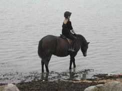
As I was walking down Thorney Island towards the gateway into the army base I came across a few horses in a field. I gave a couple of them some grass and patted them, and as I walked along the narrow sea bank they all followed closely behind me. Whenever I stopped the lead horse would stop, and I could reach out and pat it. As I approached the gate that marks the entrance to the army base the horses stopped as he path was getting narrow with bushes on either side; and thus my feeling of being a pied piper of horses also finished.
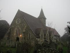
To gain access to the army base you have to press a red button on a yellow intercom. The guard asked me for my name and address, and after I had given them the gate opened and I entered the range. The route through the range is simple; just keep as near to the waters edge as possible, and is marked by a series of yellow marker poles. As I passed the lovely little church at West Thorney the path seemed to come to an end at the edge of the water beside a house. I walked back past the church and found a battered fingerpost lying on the ground. Both fingers were pointing straight on, so I assumed that the route to the water was the correct one. When I got back there I could see that there was a distinct path along the shingle under the water, so I bit my lip and sloshed my way through the water. After about fifty yards the path climbed back up onto the top of the bank, and there I found another fingerpost, except this one had a finger pointing inland, marked 'high tide route'. I can only assume that the fingerpost that was on the ground by the church used to have three fingers, but the one pointing inland has been removed, which is highly annoying.
The rest of the path through the range varied from being firm underfoot to very boggy, with large pools of water blocking the path. All the way around the island I could hear the sound of gunfire, which would certainly annoy and unnerve some people, but I have heard so many guns since I started this walk that it does not concern me. By the time I reached the western gate that leads out of the base it was starting to get late and I still had a fair distance to go. I pressed the intercom button and the guard took my name and address again. I heard the solenoid go, but when I pulled it the gate was still locked. The guard tried again, but it was still stubbornly locked. He then asked me to wait, and about ten minutes later a squaddie turned up in a Land Rover with a bunch of keys to manually open the gate. Unfortunately he had trouble opening the gate even using the keys, but eventually he did manage it and was nice enough to apologise for the delay. I laughed it off, and remarked that usually the army try to stop people coming onto their bases, and not getting off!
Today I have reached a very major milestone on the walk - I have now completed one quarter of the entire walk. A few days ago I was unsure how I would feel about this, but I can now say that I am distinctly underwhelmed. I am unsure about why this is, but I think that it may be because it was such a busy day that I am too tired to really let it sink in. All I know is that there is a massively long way still to go, and that it is going to be a great walk.
Directions
This walk starts off from the phone box in Chidham. Walk northwards along the road until you reach a private road leading off to the right. Turn right and follow this road until it ends at the western bank of the Bosham Channel. When the road ends a footpath continues on along the foreshore of the channel for a short distance before climbing up onto the banking and continue aouthwards. The path makes a diversion inland around a little boatyard to the east of Cobnor House and rejoins the bank on the southern side of the yard. From here a good surfaced path continues on southwards to Cobnor Point.
At Cobnor Point the surfaced path continues on northeastwards for a short distance until it ends and the footpath drops down to the side of the channel. The path then continues on northwards, alternating between running along the top of the bank and at the base of it, which could make the path difficult to navigate on very high tides. In places the bank is very eroded, which may also make progress difficult. The path passes Chidham Point and eventually turns to the left to head westwards for a little under a mile along the top of the bank to the south of Nutbourne and Prinstead.
When the path meets the end of a road in Prinstead it turns to the left and heads southwards towards a marina. The path crosses over part of the marina using a bridge before continuing on southwards to Prinstead Point and then onto a straight, wide bank that leads to the gate that allows entry into the army base. Go through the gate and follow the bank ssouthwards towards Stanbury Point. Yellow posts mark the path through the base, and there are plenty of warning signs telling you not to stray off the path.
From Stanbury Point the path heads southwards into West Thorney, again following the bank. A little way past the church a path leads off to the right inland; this is only to be used if the tide is high as the next section of path goes down onto the bed of the channel southwards past some houses for about fifty or a hundred yards before rejoining the inland route. The route along the channel should only be used when the tide is not high; it was fairly dangerous doing it when the tide was high.
The path leaves West Thorney and heads south towards Longmere Point along a well-defined path. At the point it turns to the right and starts to head in a more northwesterly direction for a couple of miles to Marker Point. At times the path heads a little way inland; at these points the path is well marked by the yellow posts. From Marker Point the path heads in a northerly direction but twists and turns as it does so. Eventually at Wickor Point the path reaches the gate that leads out of the army base, and the path follows a dead-straight sea wall with a good firm track at the base of the bank to the right.
Eventually after about a mile the path reaches some houses on stilts on the southern side of Emsworth Marina. Keep on the bank through the first part of the marina, and then turn to the right along a track that leads for a couple of hundred yards past the marina and then turn left down another track to head northwards. This track eventually meets a road that leads to the A259 road. Turn left to head westward along the A259 road, passing a lake and then take the first road off to the left. This heads into Emsworth, and immediately after it turns sharply to the right take a narrow lane that heads off to the left.
This lane leads for a few hundred yards before ending at some steps that leads down onto the foreshore. Go onto the foreshore and then turn right along a footpath that runs westwards along he foreshore for a hundred yards before climbing up onto a seawall. Turn left along this seawall that divides the sea from an inland lake. When the sea wall ends continue on westwards along a footpath that skirts the very southern edge of Emsworth before going across fields to a lovely little church. At the church turn right up a lane that almost immediately curves to the left and then the right. At the right-hand bend turn left and go along a path through the graveyard.
Just before the southern end of the graveyard turn right through a stile that leads to another path that heads to the edge of the channel. The path then drops down to the foreshore and heads westwards until it reaches an old tide mill and windmill in Langstone. Here the path rises up and joins a lane the heads westwards before ending at the A3023 road. Turn left and walk down the pavement beside the A2023 road until you get to the Ship Inn, where this walk ends.
Distances
| From | To | Distance (m) | Ascent (ft) | Descent (ft) |
|---|---|---|---|---|
| Chidham | Prinsted | 5.5 | 75 | 79 |
| Prinsted | Langtstone | 10.5 | 171 | 171 |
This makes a total distance of 16.0 miles, with 246 feet of ascent and 250 feet of descent.
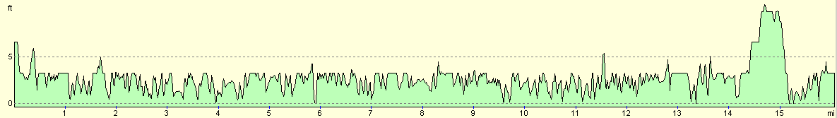
For more information on profiles, ascents and descents, see this page
Accommodation
We stayed at the Southsea Leisure Park, Melville Road, Southsea, Hampshire PO4 9TB. They can be contacted on 023 9273 5070. This site cost us eleven pounds for the night including electrical hook-up, and was a reasonable site, although I did not like the showers that much.
Disclaimer
Please note that I take no responsibility for anything that may happen when following these directions. If you intend to follow this route, then please use the relevant maps and check the route out before you go out. As always when walking, use common sense and you should be fine.
If you find any information on any of these routes that is inaccurate, or you wish to add anything, then please email me.
All images on this site are © of the author. Any reproduction, retransmissions, or republication of all or part of any document found on this site is expressly prohibited, unless the author has explicitly granted its prior written consent to so reproduce, retransmit, or republish the material. All other rights reserved.
Although this site includes links providing convenient direct access to other Internet sites, I do not endorse, approve, certify or make warranties or representations as to the accuracy of the information on these sites.
And finally, enjoy your walking!
This walk was mentioned in the following routes:
| My walk around the coastline of Britain |
Nearby walks
| # | Title | Walk length (miles) |
|---|---|---|
| 301 | Pagham to West Itchenor | 19.4 |
| 302 | West Itchenor to Chidham | 14.9 |
| 304 | Langstone to Tipner | 16.8 |
|
|

|