Walk #295: Dungeness to Winchelsea Beach
 |
 |
|
General Data
| Date Walked | 13/12/2002 |
| County | Kent, East Sussex |
| Start Location | Dungeness |
| End Location | Winchelsea Beach |
| Start time | 08.10 |
| End time | 14.53 |
| Distance | 17.1 miles |
| Description | This was a nice walk westwards along the coast from Dungeness up to Rye, and back to the coast and down to Winchelsea Beach. |
| Pack | Today I carried my 30-litre Karrimor HotRock rucksack, which was filled with my packed lunch, waterproof leggings, water bottle and a couple of spare shirts, together with the usual assortment of odds and ends. |
| Condition | I feel absolutely fine after this walk, and had no real problems that I can report. My ankle was fine today, which I am very glad about. The wooden legs that I had yesterday had disappear by this morning, and this helped me cope with the early part of the walk along the shingle beach through the army range. The shingle was very hard on the underside of my feet, but no lasting aching came of it. |
| Weather | It was a very grey day today, and there was very little wind and it was quite mild compared to recently. There was a little drizzle in the air early on, and just before I had lunch it started to rain heavily, but I missed the worst of this due to a strategic visit to the pub. It started raining again a few minutes before the walk ended, but again I avoided getting wet as Sam arrived at the same time as me. I was quite fortunate, as it continued raining for many hours afterwards. |
| OS map | Landranger number 189 (Ashford & Romney Marsh, Rye & Folkestone) |
 |
 |
|
 |
 |
|
Map of the walk
Maps courtesy of Google Maps. Route for indicative purposes only, and may have been plotted after the walk. Please let me have comments on what you think of this new format. For a detailed table of timings for this walk, please see the table file.
 |
 |
|
Notes
This was a walk that had not really featured in my mental picture of the walk - it is very much a walk to fill in the gap from the walk down to Dungeness, which I had been looking forward to, and the walk over Beachy Head and the Seven Sisters that I am looking forward to. Despite this I was very surprised that the walk was very nice, with lots to see once the initial walk past the Lydd Ranges was over.
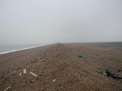
I had planned to walk around the Lydd army ranges, but when I reached the entrance to the range there was no flag or light showing. I read the signs explaining about the range rules, and decided that I could proceed through the range. The walk along the shingle beach was very hard on my feet and they ached a great deal by the time that I got through to the other side of the range at Jury's Gap. Shingle has to be the worst surface to walk on, worse than snow or deep mud, as it is so uneven and I am very paranoid about going over on my bad ankle. In places on the range there were the remains of old shells; whether they had landed there or been washed up from out at sea I do not know, but I found it intriguing to look at them without touching them. The range itself looked desolate and deserted except for a couple of mechanical diggers driving around.
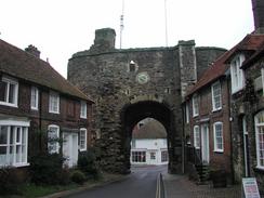
Rye was a beautiful town and it was well worth walking through. The tall gatehouse was very nice, and it was interesting to see cars go through it along the one-way system along the narrow, cobbled streets. The town is on a hill trapped between three rivers - the Rother, the Tillingham and the Royal Military Canal. I enjoyed ambling through the town and could easily have spent much more time looking around and exploring the streets. It is nice to see a town that is so unspoilt, with old, fifteenth century inns and lovely buildings. It is truly a beautiful town, and I will come back sometime to explore it more closely.
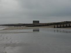
It appears that the coastline here is silting up as quickly as the coastline in East Anglia is eroding away - at one time Rye and Wnchelsea were both ports (they are now both significant distances inland), and at Rye Harbour there is a Martello Tower that looks over a large area of land. Camber Castle too was once coastal, but is now miles from the sea. To keep the Old Harbour in Rye operational 55,000 tons of shingle has to be dredged every year from the harbour mouth - a sign of how quickly it builds up. These problems caused an attempt to be made to create a new harbour at Winchelsea Beach. It took 63 years to build and seven Acts of Parliament, and cost £200,000 to build. However soon after it opened in July 1787 shingle blocked its entrance and the whole scheme was abandoned after just three months. All that remains of the harbour are the silted up remains of the harbour basin (now called 'Harbour Field') and the remains of the timber pier head extensions on the beach, which are visible at low tide. A classic example of a costly and unsuccessful project!
As I was literally just reaching Winchelsea Beach I got a phone call from Sam who asked me where I was going to meet her. Just as she asked the question she said that she could see me, and as I looked over to my right I could see Mervan approaching. This was exceedingly good timing, as the rain started falling harder and I could get into the van before I got too wet.
Directions
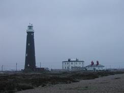
This walk starts off at the Romney, Hythe and Dymchurch Railway Station at Dungeness. From the station walk past the old lighthouse along a track that leads southwards to the shingle bank that is beside the sea. Once the bank is reached turn right and follow it westwards along either the beach, the bank or the surfaced track that runs between the bank and the power station fence.
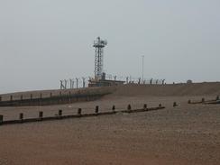
Continue on past the power stations and another, separate, building, until you reach a large concrete observation post by the shingle bank. This marks the easternmost extent of the Lydd Ranges, and if a red flag or a red light are displayed then progress along the beach is prohibited and you will have to walk inland to Lydd along a road, and back down to the coast at Jury's Gap. Fortunately the range was not closed to the public today, so I did not have to make the diversion.
Walk westwards along the shingle beach for nearly five miles past the range, until eventually another large observation post marking the western extent of the range is reached at Jury's Gap. From here you can either continue along the beach or join the road as it heads westwards for another couple of kilometres as it turns away from the beach to enter the village of Camber. Continue along the road past Camber Church and then follow it as it heads out of the village, passing a Pontins holiday village on the way.
A short distance past the holiday village a cycle path starts on the right. Join the cycle path and follow it as it follows the road before diverting away to the right to skirt around a golf course. Once cycle path passes the golf course it rejoins the road and continues on until the road turns sharply to the right. At the bend the cycle path crosses the road and continues straight on for a kilometre, passing a lake and crossing a field before ending at the A259(T) road by the bridge over the River Rother.
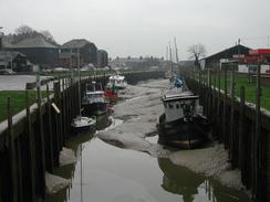
Turn left and cross over the river using the road bridge. Continue on down the A259(T) until it ends at a T-junction. Cross the road and climb up the hill in front using some steps and at the top turn left to walk westwards through the town and descend on the other side down to the A2059(T) road. Follow the road as it crosses a river and then turns to the left to head southwards past a petrol station, shortly after which a road leads off to the left. Take this road and cross the Royal Military Canal and follow the road as it heads southeastwards for a couple of miles to Rye Harbour.
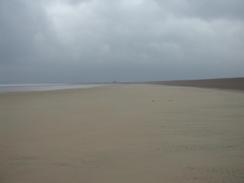
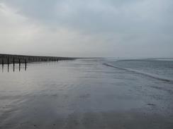
Pass the church in Rye Harbour and continue on until the road ends by some public toilets. Take a track that leads off to the right towards a Martello Tower, and jut before the tower is reached turn left through a gate down a surfaced track that heads southeastwards for a little over a kilometre until the track ends at the mouth of the River Rother. At the river mouth you can turn to the right and either follow the beach or a surfaced track that parallels the inland edge of the shingle ridge southwestwards for three miles until you reach the public toilets at Winchelsea Beach, where this walk ends.
Distances
| From | To | Distance (m) | Ascent (ft) | Descent (ft) |
|---|---|---|---|---|
| Dungness | Rye | 11.4 | 157 | 148 |
| Rye | Winchelsea Beach | 5.7 | 102 | 128 |
This makes a total distance of 17.1 miles, with 259 feet of ascent and 276 feet of descent.
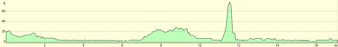
For more information on profiles, ascents and descents, see this page
Accommodation
We stayed in the car park behind the public toilets at Winchelsea Beach, which means that I will be able to get a early start tomorrow morning. Hopefully tomorrow night we may have a campsite to stay at.
Disclaimer
Please note that I take no responsibility for anything that may happen when following these directions. If you intend to follow this route, then please use the relevant maps and check the route out before you go out. As always when walking, use common sense and you should be fine.
If you find any information on any of these routes that is inaccurate, or you wish to add anything, then please email me.
All images on this site are © of the author. Any reproduction, retransmissions, or republication of all or part of any document found on this site is expressly prohibited, unless the author has explicitly granted its prior written consent to so reproduce, retransmit, or republish the material. All other rights reserved.
Although this site includes links providing convenient direct access to other Internet sites, I do not endorse, approve, certify or make warranties or representations as to the accuracy of the information on these sites.
And finally, enjoy your walking!
This walk was mentioned in the following routes:
| My walk around the coastline of Britain |
Nearby walks
| # | Title | Walk length (miles) |
|---|---|---|
| 294 | Hythe to Dungeness | 14.7 |
|
|

|