Walk #715: A circular walk from Rosedale to Hutton-le-Hole
 |
 |
|
General Data
| Date Walked | 19/02/2006 |
| County | North Yorkshire |
| Start Location | Rosedale |
| End Location | Rosedale |
| Start time | 09.25 |
| End time | 17.00 |
| Distance | 20.8 miles |
| Description | This was a superb walk over Spaunton Moor to Hutton-le-Hole, and then back across the moor to join an old railway trackbed around the head of the Seven Dale. |
| Pack | Today I carried my 30-litre Karrimor rucksack filled with my waterproofs, two litres of water, a book and various other odds and ends. |
| Condition | Unfortunately after a good day yesterday my left knee ached a few times today, most noticeably on the second ascent onto the moor. This was not a problem, however, and I had more trouble with my right shoulder which ached for nearly the whole day. |
| Weather | The morning started off bright and sunny, and the heavy frost that lay thickly on the ground soon burnt off. As the day went on the clouds gathered, some of which were grey, and the temperature dropped, although it never actually threatened to rain. |
| OS map | Landranger number 94 (Whitby & Esk Dale, Robin Hood's Bay) |
 |
 |
|
 |
 |
|
Map of the walk
Maps courtesy of Google Maps. Route for indicative purposes only, and may have been plotted after the walk. Please let me have comments on what you think of this new format. For a detailed table of timings for this walk, please see the table file.
 |
 |
|
 |
 |
|
Notes
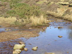
I awoke this morning after a heavy sleep in a comfortable bed to a breathtaking sight of the dale through the window, a red sky hanging over it and the moon almost painted onto the scene. It was mesmerising, and I stood by the window for a while just watching it as the scene changed minute-by-minute as the sun rose. I read for a while and, after a filling breakfast and a nice chat with the landlady and another guest, got my walking gear on and started off along the path. When I originally planned this walk it started from Rosedale Abbey, about a mile down the road. I did not want to have to walk or drive down to the start point, so I headed off along a bridleway and track that led through Low Bell End Farm. This was muddy initially and it soon got worse as the track curved around as it descended steeply downhill, although the heavy frost meant that it was not too bad as some of the muddy sections were frozen hard. The River Seven was just a stream when I crossed it via a footbridge, and after heading through a farm I reached a road on the northern side of the valley.
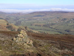
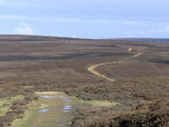
The next path led up from this road, initially along a walled track for a few yards before entering an open hillside, where it became slightly indistinct. The path that I intended to follow was on the southern side of a stream running off the moor, and I kept the stream well to my right as I climbed, passing a marker stone at the junction of two paths and continuing uphill. When the gradient started to slacked a little track was reached, and I turned left to follow this as it looped around, ascending gently to end at a wider track on the edge of the moor. This proved to be much easier walking as it was nearly flat as it headed southeastwards, and there were some great views over the valley towards the moorland on the other side. I also realised that I had mobile reception, so I gave Sencan a quick phone call as I passed a seat commemorating the ironstone miners who worked on the moors. Indeed, I realised that the track that I was walking along must have been an old railway line, it was so flat and gentle, and looking at the map I could see where the line used to go, one part looping down from the moor and terminating near my B&B.
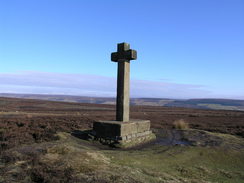
In the sunshine it was a nice walk, and I pushed myself on, crossing a road at the top of the steep Chimney Bank and continuing on downhill until a cross became visible a short distance to the right. As it was not too far away I decided to visit it, using a little path to reach Ana Cross, which glowed with a yellowish tint in the morning sunshine. The sight made me feel elated, and I headed back to the track and continued on it downhill with a faster pace as a result. Aside from two mountain bikers that I had met near the road the moors were deserted, and the solitude was quite uplifting. The track slowly descended, and when the moorland started to be replaced by enclosed fields I left the track, and started descending steeply across a scrubby field towards a stream, which, although there was no bridge, proved simple to ford. On the other side of the stream the path rose up, and was easy to follow on the ground as it skirted a wall and a new area of woodland to the left.
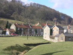
It took longer than I expected to reach the village of Lastingham, and when I did I had a long and unplanned walk down a road into the centre of the village. Back at the B&B this evening I discovered from my GPS track that I had gone a fair bit off course, heading northwestwards across the moor before heading westwards along a track. I am at a loss to explain where the path should have gone after leaving the stream, as the path that I followed was very distinct on the ground. It did not make much difference in the long run, and after descending the long road down into the centre of the village I passed the church and a pub that appeared to be very welcoming, before heading westwards out of the village along a road. This was fairly quiet as it exited Lastingham and started heading towards Hutton-le-Hole; however, before the village was reached a footpath headed off to the left. I decided to take this, and after descending down to a stream through some woodland it headed across fields into the village, on what must be a far better walk than that along the road.
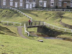
Hutton-le-Hole was as beautiful as I remembered it from when I had been there years before, and in the sunshine it felt more like a late Spring day than one in mid-February. I followed the road uphill, passing the stream that divides the village on the left, passing a little museum and reaching the village pub. I was about to enter to have a pint when I noticed a sign on the door stating no muddy boots; one of my big toes was hurting and I did not want to aggravate it by taking my boots off, so instead I walked back down through the village to a shop, where I bought a carton of orange juice and an ice lolly. It was still a sunny day, so I left the shop and sat on a bench neat the war memorial where I drank the orange juice and looked around the beautiful village. After giving myself a little rest I decided to head on, and after looking at the place where a stream emerges from the ground I decided to forego my planned route along the road northwards on the western side of Hutton Back, and instead headed for a short distance along a road, passing a car park and some toilets, before taking a footpath that headed northwards.
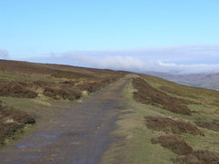
As soon as I started along this path the clouds started to gather, and coincident with this it started to get much colder. The path was narrow but distinct on the ground as it climbed, fortunately not too steeply with Hutton Beck to the west, and the view across the moorland were made bleaker by some grey clouds overhead. The path met and joined a surfaced track for a short distance, the dark grey of the tarmac contrasting harshly against the colours of the moors, before leaving and climbing uphill to the north once more. The path was initially quite boggy in places, but as it climbed it became firmer and easier to walk along before it eventually ended at a T-junction with a broad footpath across the moors. My intended route was to follow this path northeastwards, but as that meant I would have to walk along some path that I had already walked on earlier on I decided instead to head directly northwards, aiming for the trig pillar at the highest point on the moor.
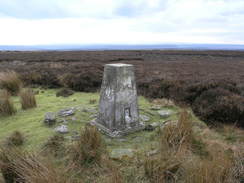
On the map it looked as though this meant that I would have to tramp across trackless moors, but a few yards away to the left I could see a track. I decided to investigate this, and as it looked as though it was heading in the right direction I decided to follow it. The track was not on the map, and I therefore carefully checked at regular intervals to ensure that it was heading in the correct direction. It was, and it took me on for over a kilometre in the right direction, before eventually petering out. Here I found what looked like a brand-new compass on the ground, so I picked it up and headed on across the moors. The going was easier than I expected and I came across the trig pillar suddenly, it rising out of the surrounding brown moorland when I was nearly on top of it. It seemed like a good place for a rest, so I took my rucksack off and sat down with my back to the pillar, and watched the breeze blow the clouds along high above the moors. There were some fairly expansive views, and I could imagine that if the weather had been sunny and clear they would have been absolutely fantastic.
After a while it started to get slightly chilly, so I put my balaclava on and started off, heading northwards across the moors, heading towards the track that runs across the eastern edge of the moors. The going was slightly harder than it had been on the way up to the trig pillar, and a couple of minutes before I reached the track a farmer went by a hundred yards to my left on a quad bike and trailer, so I assume that there must be a track of some description there. I hit the track at a point where three girls were standing by their bikes, giggling away as one of them started walking south. After recording my position using my GPS I asked them what the problem was, and it turned out that the peddle had fallen off one of the bikes, and the girl was going back to look for it! Giggling lightly to myself I walked on, and in a few places I came across the industrial heritage of the moors; a mostly-ruined building here, the ghostly impressions of the old railway sleepers in the ground there. As I walked I tried to work out where the railway line must have gone, and aside from the obvious route around the head of the dale, there appeared to be another branch heading northwestward across the moors towards Battersby Junction.
The walk was easy going and I listened to my Walkman as I walked; whereas the moors had been nearly deserted this morning it was relatively busy this afternoon, with a fair few people out cycling along the old railway line. The track passed a car park and neared the Lion Inn, where I had intended to head back down into the Dale and back to the B&B. However I was still feeling fit and there was still a couple of hours of daylight left, so I decided to extend the walk by continuing along the railway line. The track soon became narrower and then became a path as it almost imperceptibly descended, and as it neared the head of the dale there was a very boggy section where small landslips had obliterated the old line. These proved easy to negotiate and I strolled on to a beautiful curved embankment that used to carry the old railway line around the head of the valley, and the views from here southeastwards down the valley were superb.
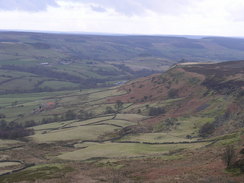
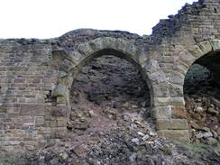
On the eastern side of the valley the going became harder, with the old line going into cuttings that were now flooded, and the path climbing up onto the sides of the cuttings. These flooded cuttings were full of reeds, and the yellow-white colour of the reeds contrasted nicely against the darker colours of the cutting sides. A short but very boggy section followed, and once over this the going became easier as another cutting was negotiated and the path curved around a little valley. I made good time as I walked along from here, and soon reached the remains of dramatic and tall structures on the left, which I assume were part of the old mines. The first of these was quite ruinous, but about half a mile further on there was a set of stone arches that were in better condition, although still ruinous in parts, with a stone arch standing proud above the rubble. The ruins were quite majestic, and although they seemed massive when standing next to them, when I had looked across to them from the other side of the valley a couple of hours before they had seemed tiny against the dramatic scale of the valley side.
These ruins were surrounded by more, smaller ones, and shortly afterwards the track came to an end by a series of large spoil heaps, and I felt sad to be leaving the old railway line behind me as it had been an enjoyable stroll. A track took me down past a farm to Hill Cottages, and here I joined a road that headed back towards the B&B. The very last stretch of the walk was up a hill that proved to be hard on legs that were looking forward to the end of the walk, and I welcomed the final descent down the driveway that led to the B&B. I entered and almost immediately had a long and welcome soak in the bath, letting the waters take some of the usual aches and strains out of my body. I left to drive down to the village at around eight, and after a lovely meal of scampi and chips in the hotel I headed back to the B&B, where I almost immediately feel into a seep and welcoming sleep.
 |
Directions
This walk starts off at the Five Acre View B&B, which is situated a mile to the northwest of Rosedale Abbey. Leave the B&B and walk up the drive for a few yards, before turning left to walk along a track that heads through the middle of a farm. Once it passes the farm buildings the track curves to the left to descend downhill, curving around several times before petering out at the bottom near a stream. Enter a field and then turn left to reach a footbridge over a stream, and on the other side continue uphill, joining a track that passes through the middle of Thorgill Farm and ending at a road.
Turn right and follow the road for a few yards before turning left up the access road to a house, after a few yards take a footpath that leads off to the left. This path climbs steeply uphill to the southwest keeping a stream running in a gully away to the right. Once the gradient starts to slacken a rough track is reached; turn left and follow this track as it climbs slowly uphill to the east, eventually curving to head south and ending at a broad track. Turn left and follow this track as it heads southeastwards for a mile, passing Bank Top before reaching a road at the top of Chimney Bank.
Cross the road and on the other side continue on along the track that heads along the edge of the moor, passing near to Ana Cross before curving around, slowly descending over the next couple of miles as it passes Abraham's Cross. At SE742908, just before it meets another track, a footpath leads off to the right, running alongside a wall as it heads down to a stream. A little ford crosses the stream, and on the other side the footpath heads westwards uphill for a mile into Lastingham. However on the ground the path seemed more obviously to keep a patch of new woodland to the left, which led me a little further to the north and further uphill than the path, after which I followed a road southwards into the centre of the village and the end of the proper path.
When a road junction is reached in Lastingham turn right and follow the road as it passes the church to the left and a pub to the right. This road slowly curves around to the left eventually taking a southwesterly course before ending at a T-junction. Turn right and follow this new road as it heads westwards for a little under a kilometre; just before the road heads downhill to cross a stream a footpath leads off to the left, heading through an area of woodland to cross a stream, then emerging from the woodland and crossing a couple of fields southwestwards to end at a road in Hutton-le-Hole.
At the road turn right and start following the road northwards through the village, passing the pub on the right until a road junction is reached. Turn right along this road and follow it as it passes a car park; shortly after this turn left to join a footpath that heads northwards, entering the moorland and slowly climbing for about half a mile until a surfaced track is reached. Turn left and follow this track northwards for a few hundred yards until it curves to the left, and then continue straight on along a footpath. This climbs slowly uphill and is quite rough underfoot, and after about a kilometre it crosses a track to the northeast of Spaunton Lodge.
Turn left along this track for a few yards and then turn right along a rough path that leads northwards across Spaunton Moor; the path is not marked on the map but is fairly clear on the ground, and is better than trying to cross directly across the moor. After about a mile the path ends near some shooting butts, and from here make your way slightly west of north across the moors for a few hundred yards to the Spaunton Moor trig pillar. From the pillar head directly north across the moorland for about half a mile until it meets a wide track. Turn left and start following this track (actually an old railway line) as it heads north along the eastern edge of the moor. It is easy to follow as it does so; at the northern edge of the moor it nears a car park; do not enter this but keep on this track as it continues contouring along the western side of the valley.
The track becomes a path and is rougher before it curves around the head of the valley after which it settles on a southeasterly course along the eastern side of the valley. In a couple of places the path rises up onto the top of cutting sides, the cuttings below being boggy and covered in reeds. Eventually the path passes under two sets of old kilns, and then ends by some ruined buildings near a large spoil heap. Pass an information board and turn right to head through a farm along a track that ends at a road at Hill Cottages. Here turn left, and walk southeastwards for a little over a kilometre, descending downhill to School Row before climbing uphill once more. A road comes down from the hillside on the left; here turn right down a driveway that leads to the Five Acre B&B, where this walk ends.
Distances
| From | To | Distance (m) | Ascent (ft) | Descent (ft) |
|---|---|---|---|---|
| Five Acre View B&B | Lastingham | 7.0 | 853 | 1109 |
| Lastingham | Hutton-le-Hole | 1.9 | 112 | 141 |
| Hutton-le-Hole | Car park near Lion Inn | 6.4 | 1082 | 213 |
| Car park near Lion Inn | Five Acre View B&B | 5.5 | 489 | 1073 |
This makes a total distance of 20.8 miles, with 2536 feet of ascent and 2536 feet of descent.
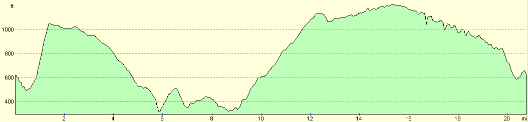
For more information on profiles, ascents and descents, see this page
Accommodation
I spent the night at Five Acre View, a superb B&B situated about a mile to the north of Rosedale Abbey. The room cost me £30.00 for the night, and I awoke both mornings that I stayed there to superb views over towards the moors. The breakfasts were large and filling, and the hot made me feel very welcome. The address is Five Acre View, Rosedale Abbey, Near Pickering, North Yorkshire, YO18 8RE. They can be contacted at (01757) 417830, or by email at fievacreview@aol.com. They have a website at 5acreview.co.uk.
Disclaimer
Please note that I take no responsibility for anything that may happen when following these directions. If you intend to follow this route, then please use the relevant maps and check the route out before you go out. As always when walking, use common sense and you should be fine.
If you find any information on any of these routes that is inaccurate, or you wish to add anything, then please email me.
All images on this site are © of the author. Any reproduction, retransmissions, or republication of all or part of any document found on this site is expressly prohibited, unless the author has explicitly granted its prior written consent to so reproduce, retransmit, or republish the material. All other rights reserved.
Although this site includes links providing convenient direct access to other Internet sites, I do not endorse, approve, certify or make warranties or representations as to the accuracy of the information on these sites.
And finally, enjoy your walking!
Nearby walks
| # | Title | Walk length (miles) |
|---|---|---|
| 714 | A circular walk from Helmsey to Rievaulx Moor | 20.2 |
| 716 | A circular walk from Rosedale around Wheeldale Moor | 17.4 |
|
|

|