Walk #824: Havant to Petersfield
 |
 |
|
General Data
| Date Walked | 05/01/2009 |
| County | Hampshire |
| Start Location | Havant station |
| End Location | Petersfield station |
| Start time | 08.50 |
| End time | 14.28 |
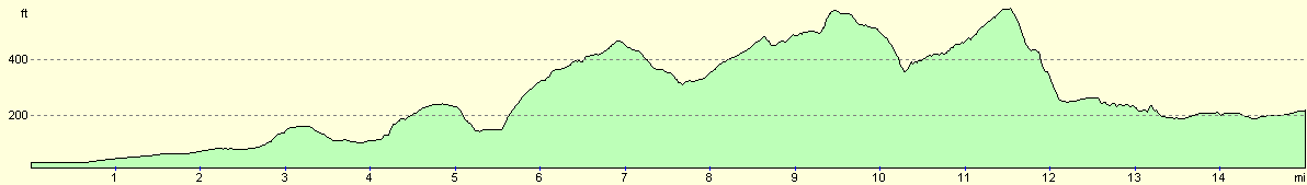
| Distance | 15.0 miles |
| Description | This was a relatively short stroll, following the Staunton Way north to the Queen Elizabeth Country Park, where the Hangers Way is joined as far as Petersfield. |
| Pack | Today I carried my 30-litre Karrimor rucksack, filled with waterproofs, a flask and other odds and ends. |
| Condition | I feel absolutely fine after this walk. |
| Weather | Today's weather was very mixed - occasionally sunshine was interspersed with black clouds and snow flurries. It was a bitterly cold day, especially when exposed to the breeze. |
| OS map | Landranger number 197 (Chichester & The South Downs, Bognor Regis & Arundel) |
 |
 |
|
 |
 |
|
Map of the walk
Maps courtesy of Google Maps. Route for indicative purposes only, and may have been plotted after the walk. Please let me have comments on what you think of this new format. For a detailed table of timings for this walk, please see the table file.
 |
 |
|
 |
 |
|
Notes
Some time ago I planned a walk, heading northwards from Havant, crossing the South Downs Way, and ending at Liss. This would open up some new areas to go walking, and should also be a very pleasant walk. Today I decided to do that walk, especially as the various stations on the route would allow me to cut it short if I had any troubles. At the end of last year I did very little walking, and I am very out if shape. The journey to Havant was annoying; the traffic on the M27 was down to a crawl at times, and therefore I parked my car at the station in Havant about an hour later than I expected. I quickly pulled my kit together, and set off on the walk.
My route would take me north out of the town, but first I made a little diversion south, in order to walk along East Street, which I had walked previously. Near the station there was a newsagents that allowed me to buy some provisions for the day ahead. Havant just seemed to be waking up, and after passing the museum I joined a footpath that followed the old railway line to Hayling Island. This ended by the car park at Hayling station, just a few yards from where I had parked my car!
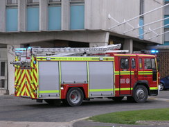
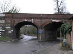
Roads took me northwards past an industrial estate. At one point a fire engine roared past, sirens blaring out over the surrounding roads. As I neared the end of the road there was a big building off to the left, and the fire engine was parked outside it with lots of employees standing around. As this was he first Monday back to work for many people, it had started well for that company!
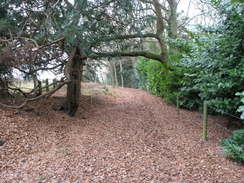
I put my Walkman on as I headed north across a footpath that led to the B2148, then I took a bridleway that led through trees. This path had a useful sign stating that the bridleway had been in use since the tenth Century, and for six Centuries it was the main route into Rowlands Castle. It made for a pleasant walk, with a cushion of brown fallen leaves underfoot.
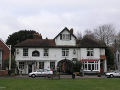
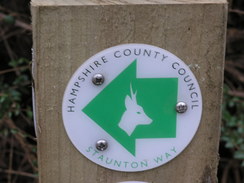
Rowlands Castle itself was pretty, with a long, linear village green with a couple of pubs and houses arrayed alongside. I put on another EscapePod onto my Walkman, and continued on through the village. This short section of the route followed the Monarch's Way, a long-distance path that I have been encountering a lot recently, and which I want to do sometime in the future. A road took me away from the village, and then a path climbed uphill across a railway line. Here it joined the Staunton Way that would be followed for the next few mines. The path then started descending down into Finchdean.
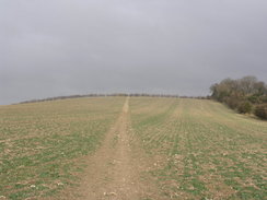
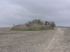
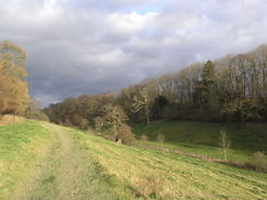
What followed was perhaps the best bit of the day's walk; the path climbed up onto Idsworth and Chalton Down, where a series of snow flurried blew in. The ground became peppered with snow, and despite the cold it was quite exhilarating. In summer the views must be fantastic, but despite the reduced views it was an exceptional walk. At the top of Chalton Down was a green ring of a tumulus, standing proud of the flinty ploughed land that surrounded it.
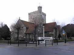
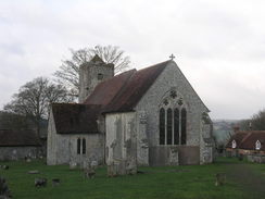
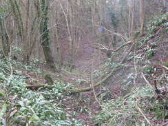
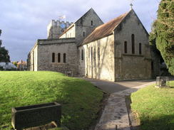
The path eventually descended down to Chalton church, a fairly ordinary flint structure with signs of patchwork repairs on the tower in brick. Opposite the church there was a pub; I had not walked far enough in the day for a break, so instead I plodded on, following the Staunton Way as it climbed up to meet the woodland of Queen Elizabeth Forest. Once in the forest the path followed a track with a steep drop off to the right; there were occasional views through the trees of a road far below, and of a house with a large outdoor swimming pool.
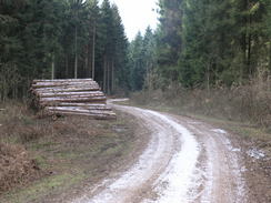
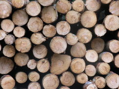
As the track ascended through the woodland there were signs of snow lying on the ground, tiny flecks that had not yet melted. Piles of logs lay at the side of the track and, later, a couple of lorry trailers with their loads safely secured. The descent was gradual, although the views were non-existent due to the surrounding trees.
Eventually the track led me out to a car park at the bottom of the hill, and here the South Downs Way was joined for a short distance. Another track took me uphill, and soon a large hut was reached on the right by a barbecue area. This seemed like an ideal spot to stop for lunch, so I went inside and sat down on the bench. Inside my pack there was a flask of chicken soup, still warm, along with some bread. The water in my bottle was very cold, so I would take a mouthful of cold water before drinking the soup, warming myself up in the process. It was a most enjoyable break.
It was obvious that I would not be able to complete the entire walk to Liss - there simply were not enough hours left in the day, Instead, I resolved to walk as far as Petersfield, which would make a short, fifteen mile day. This was a disappointment, but not one that I was going to dwell on for too long after such a long lay-off from serious walking.
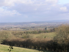
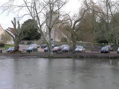
The track led up to a summit, from where there were some good views northeast over Buriton, along with yet another trailer load of timber. The next descent was steep, and when a road was met I bade the South Downs Way goodbye, and joined the Hangers Way. A path took me down through the Buriton chalk pits, a pleasant wooded location, and once obviously a site of major industrial activity. At the bottom a track led under a dreary railway bridge, and soon I was passing an icy pond in Buriton itself.
I stopped to have a quick look at the church, then headed out of the village. The path entered a lovely little valley with a small stream running along the base. It skirted high up on the left-hand side, before passing a sewage farm that seemed singularly ill-placed. The valley slowly opened out, and the Hangers way took me on through a caravan park.
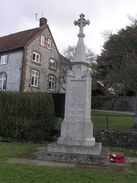
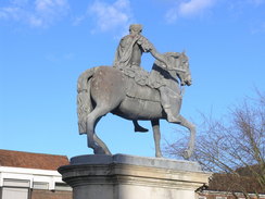
A road walk then led me on into Petersfield. I had been here just before Christmas to hear a talk by the author Simon Brett, which had been a very enjoyable evening. Now, however, I was resolved to get to the railway station as quickly as possible. I had no idea what time the next train was so, aside from taking a few photographs of the statue of William III in the town centre, I strode through to the station. I was in luck; the next train was due imminently, so I purchased a ticket and just managed to make it onto the platform in time. It had been a short walk for me, but an enjoyable one nonetheless.
 |
 |
|
 |
 |
|
Directions
This walk starts of from Havant station. Leave the station, and walk south down North Street until it reaches East Street. Then turn left, to start heading eastwards along East Street. When an old bridge is reached with a car park on the right, turn right to descend down to the car park, and then turn left to start heading northwards along an old railway trackbed. This immediately passes under a rail bridge, and continues on along the route of the old Hayling Billy railway line to Hayling Island. After a quarter of a mile this ends at a gate by a road, immediately to the east of the railway station. (If you do not wish to do this first part of the walk, simply turn left out of the station and walk eastwards through the long linear car park, with the railway line on the left, until it ends at a road.)
Turn right along this road, and follow it as it immediately crosses the railway line on a level crossing. On the other side the road ends at a crossroads; continue straight on along New Lane for about a mile, with an industrial estate on the right. When New Lane ends at a T-junction with Bartons Road turn right along the road for a short distance, and almost immediately turn left to head northwards along Wakefords Way. As this passes a playground on the right leave the road and enter the playground, and then turn left to start walking north across some playing fields. Skirt immediately to the left of a small building, and continue on as the road curves away to the left.
The footpath continues on northwards once the playing fields end; crossing a field and joining a track that ends at the B2148 road. Turn left along this road for nearly a third of a mile; there is no pavement, so care needs to be taken. Just after a road comes in from the left, a bridleway leads off to the right. Take this footpath and follow it northwards for three quarters of a mile. When it ends at a track, turn left and walk down to a road in Rowlands Castle. Turn right and walk along this road, keeping the village green on the left, and walk under a railway bridge. Ignore a road that heads off to the right, and follow the road as it curves to the left to head northwards.
About a quarter of a mile after the bend in the road, a footpath leads off to the left. This climbs between houses before reaching a bridge over a railway line. On the other side of the line it climbs uphill across a field northwestwards towards the end of a band of woodland at Great Wellsworth. Before the buildings are reached, turn right to start following the Staunton Way northwards along the unsurfaced Wellsworth Lane.
After half a mile this descends down to meet a road. Turn right and follow this road as it strikes downhill to the north, soon joining joining another road. Follow this onwards for a short distance into Finchdean, and then at a triangular road junction turn to the left to start following a road northwestwards. Shortly a lane comes in on the right; immediately after this turn right to join a footpath that enters a field. Turn left to walk along the field wit the hedge on the left. When this reaches another hedge, turn right to start climbing uphill with a hedge on the left. The path continues on uphill; soon turning to the left to walk alongside Oxleys Copse before curving to the right to climb to the top of Idsworth Down.
Once at the top it becomes a simple walk along the ridge, climbing up northwards onto Chalton Down before descending downhill. Near the bottom, a path leads off to the left, crossing a field before entering the graveyard of Chalton church. Pass the church, and join the road. Turn right down the road, immediately passing the pub on the left, and when the road forks take the right-hand fork. At the end of this, head straight on along a track called North Lane, still following the Staunton Way. Follow the track uphill for nearly a mile until it reaches the southern edge of the Queen Elizabeth Forest.
Enter the woods, and immediately turn to the right to join a track. Initially this heads eastwards, before curving to head in a more northerly direction. The track modestly climbs and falls as it takes a sharp-left hand bend, then curves to the right. When a complex junction of tracks is reached at SU729182, turn left and follow a track that climbs uphill to the west. This soon starts dropping downhill once more, and eventually ends at a car park at the junction of the Staunton and South Downs Ways, immediately to the south of the Queen Elizabeth Forest Visitor's Centre.
Turn right and start following the South Downs Way northeastwards along the bottom of the valley. When the track makes a hard-left, continue straight on along another track past Benham Bushes. When the top of the hill is reached, continue on along the South Downs Way as it descends another track, with the edge of the woodland on the right. This ends after half a mile at a road junction near Fagg's Farm. From here the route follow the Hangers Way for the rest of the day.
At the road junction take a track that heads downhill to the northeast through Burtiton chalk Pits. This eventually passes under a railway line , then becomes South Lane as it curves around into the village of Buriton. It passes a large pond on the right; when this ends turn right up towards the church, and then turn left for a few yards, before turning to the left once more along another road. By an old building, turn right along a footpath. This stays hight up on the left-hand side of a valley; it passes a sewage works at the bottom of the valley, then enters some woodland. Eventually the valley flattens out, and the path continues on, crossing a stream on a footbridge and continuing across fields.
It then crosses a stile into a caravan park; when a track is reached, turn right and then turn left to head northwards until the track reaches the B2070 road. Turn right and follow this northeastwards for nearly half a mile into Petersfield; on the way it crosses a roundabout. Turn left along St Peters Road, and follow it as it curves to the right past the church to reach the square in the middle of Petersfield. Turn left and then right to head up Chapel Street, and then take the first road off to the left, which heads up to Petersfield station, where this walk ends.
Distances
| From | To | Distance (m) | Ascent (ft) | Descent (ft) |
|---|---|---|---|---|
| Havant station | Rowlands Castle | 3.8 | 144 | 69 |
| Rowlands Castle | Queen Elizabeth park | 6.5 | 820 | 541 |
| Queen Elizabeth park | Petersfield | 4.7 | 400 | 568 |
This makes a total distance of 15.0 miles, with 1364 feet of ascent and 1178 feet of descent.
For more information on profiles, ascents and descents, see this page
Transport
There are regular train services running directly between Petersfield and Havant. See the National Rail Enquiries website for more details.
 |
 |
|
 |
 |
|
Disclaimer
Please note that I take no responsibility for anything that may happen when following these directions. If you intend to follow this route, then please use the relevant maps and check the route out before you go out. As always when walking, use common sense and you should be fine.
If you find any information on any of these routes that is inaccurate, or you wish to add anything, then please email me.
All images on this site are © of the author. Any reproduction, retransmissions, or republication of all or part of any document found on this site is expressly prohibited, unless the author has explicitly granted its prior written consent to so reproduce, retransmit, or republish the material. All other rights reserved.
Although this site includes links providing convenient direct access to other Internet sites, I do not endorse, approve, certify or make warranties or representations as to the accuracy of the information on these sites.
And finally, enjoy your walking!
Nearby walks
| # | Title | Walk length (miles) |
|---|---|---|
| 301 | Pagham to West Itchenor | 19.4 |
| 302 | West Itchenor to Chidham | 14.9 |
| 303 | Chidham to Langstone | 16.0 |
|
|

|