Walk #318: Wyke Regis to West Bexington
 |
 |
|
General Data
| Date Walked | 06/01/2003 |
| County | Dorset |
| Start Location | Wyke Regis |
| End Location | West Bexington |
| Start time | 08.02 |
| End time | 13.38 |
| Distance | 14.3 miles |
| Description | This was a nice walk northwestwards, roughly following the coast and not Chesil Beach. Unfortunately the route leaves the coast and heads inland slightly to the east of Abbotsbury, but even this was not a bad diversion, with some lovely views to be had over the Fleet and Chesil Beach. |
| Pack | Today I carried my 30-litre Karrimor HotRock rucksack, which was filled with my packed lunch, waterproof leggings, water bottle and a couple of spare shirts, together with the usual assortment of odds and ends. |
| Condition | I feel fine after this walk, and do not have any problems to report. I could easily have walked further, but I really did not fancy it at all. |
| Weather | The weather today was the same as yesterday; sunny with only a few clouds but bitterly cold, particularly when I was exposed to the wind. Despite this it was not a bad day for a walk, and the cold did not spoil my day at all. |
| OS map | Landranger number 194 (Dorchester & Weymouth, Cerne Abbas & Bere Regis) |
 |
 |
|
 |
 |
|
Map of the walk
Maps courtesy of Google Maps. Route for indicative purposes only, and may have been plotted after the walk. Please let me have comments on what you think of this new format. For a detailed table of timings for this walk, please see the table file.
 |
Notes
I quite enjoyed this little walk, particularly as it was a beautiful, sunny day. I had to wrap myself up well to try to keep the cold out, but that was a small price to pay for the sunshine, which was generally glorious. I think that it is not a good idea to complain too much about cold but sunny weather, as many of the alternatives - for instance cold, wet and windy weather - are far worse. I can only hope that the sunny weather continues for as long as possible, as it is very nice to walk in and allows me to take some good photographs.
After yesterday's little diversion around the Isle of Portland it was nice to get back onto the path proper on an enjoyable walk further westwards. There was a diversion inland to he east of Abbotsbury, and this allowed some lovely views around the surrounding area so I did not mind it that much. Yesterday I was in two minds about whether to walk along Chesil Beach or to take the inland route; although the beach route is shorter and more coastal it is over shingle, which is my least favourite walking surface. In the end the decision was made for me, as Sam had been into the visitor centre and was told that it would be impossible to walk all the way along the beach today due to firing at the army range. Strangely enough when I reached the range today the red flags were not out and I could take the path through it; I do not know if the firing was due to start later or not.
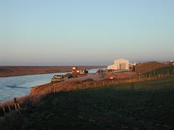
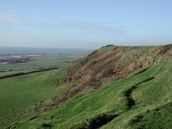
The area around Abbotsbury was beautiful, even though I did not go into the village proper to have a look around it. The views down over the village from the hills to the east were fairly spectacular, as were the remains of the fifteenth century St Catherine's Chapel on Chapel Hill, which I skirted below as I walked along, the climb up the hill to visit the ruins not proving too appealing. I also passed the car park of the swannery, which is the largest in England and was founded in the times of Henry VIII to provide birds for the tables of the monks of Abbotsbury Abbey. The swannery was unfortunately shut, as I am intrigued by the whole idea and would not have minded visiting it.
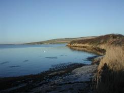
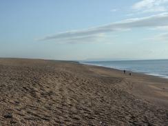
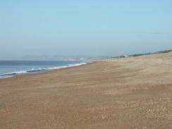
The stone grading on Chesil beach was very visible as I walked along. At the Portland end of the beach the pebbles were quite large, but at the western end of the beach they are much smaller, and there are sandy patches that made walking much easier. The pebbles are exceedingly well sorted - smugglers landing on the beach at night could tell their position to within three hundred yards simply by looking at the size of the pebbles. The power of the waves along the beach can be immense - in 1824 a 95-ton sloop was carried over the beach by a gale and placed in the Fleet on the inland side of the Beach. The whole of Chesil Beach is very impressive, particularly the scale of it - it is amazing to think how many tons of stone was needed to form it, particularly when you realise there is a vastly large amount of stone below the low-tide mark as well.
When I reached the car park in West Bexington I found the van there, but there was no sign of Sam. I phoned her up, and it turned out that she had parked the van and walked up the beach to meet me. I had been walking on the firmer sand at the bottom of the beach whilst she was walking along the top of the shingle bank, and she failed to see me as I walked along. I opened the van and took all my gear off, and eventually Sam turned up about ten minutes later. It feels really strange to be in the van without Sam, as she is usually around when I am, and the van felt empty without her around. When I get to Scotland and have to start camping out it is going to be interesting to see how well I cope without her around - mentally she helps me out massively on this walk, and I know however bad any particular day is she will be there to cheer me up and give me sympathy. I would not be so bold as to call her 'my rock', but in many ways that is the roll she fulfils for me.
Directions
| During this walk I followed the South West Coast Path, the route of which is detailed in the Ordnance Survey National Trail Guide 11, Exmouth to Poole (ISBN 1-854109-88-X). Unfortunately the route description is written in reverse to the direction that I am walking, but the 1:25,000 maps in the book are clear and the signs on the ground are very good. Also to be recommended is the South West Coast Path Association guidebook (ISBN 0-907055-04-4), which has less concise directions and no maps but does include accommodation details and grades each section of the walk according to difficulty. They also publish reverse directions, which are suitable for walking in the direction that I walked the route. They have a website at www.swcp.org.uk, which is well worth a visit. | 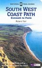
|
| 
| |
| |
| |
Distances
| From | To | Distance (m) | Ascent (ft) | Descent (ft) |
|---|---|---|---|---|
| Wyke Regis | Moonfleet Hotel | 6.0 | 600 | 600 |
| Moonfleet Hotel | Abbotsbury Swannery | 4.9 | 489 | 535 |
| Abbotsbury Swannery | West Bexington car park | 3.4 | 315 | 344 |
This makes a total distance of 14.3 miles, with 1404 feet of ascent and 1479 feet of descent.
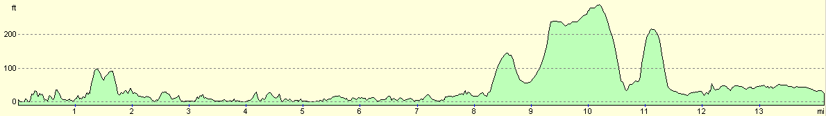
For more information on profiles, ascents and descents, see this page
Accommodation
We stayed in the car park beside the sea in West Bexington, despite the fact that there were signs stating no overnight parking. We are getting very good at ignoring such signs, as I believe that we are really not doing any harm at this time of year.
Disclaimer
Please note that I take no responsibility for anything that may happen when following these directions. If you intend to follow this route, then please use the relevant maps and check the route out before you go out. As always when walking, use common sense and you should be fine.
If you find any information on any of these routes that is inaccurate, or you wish to add anything, then please email me.
All images on this site are © of the author. Any reproduction, retransmissions, or republication of all or part of any document found on this site is expressly prohibited, unless the author has explicitly granted its prior written consent to so reproduce, retransmit, or republish the material. All other rights reserved.
Although this site includes links providing convenient direct access to other Internet sites, I do not endorse, approve, certify or make warranties or representations as to the accuracy of the information on these sites.
And finally, enjoy your walking!
This walk was mentioned in the following routes:
| My walk around the coastline of Britain |
| South West Coast Path |
Nearby walks
| # | Title | Walk length (miles) |
|---|---|---|
| 316 | Lulworth Cove to Wyke Regis | 13.7 |
| 317 | A circular walk around the Isle of Portland | 13.3 |
| 319 | West Bexington to Lyme Regis | 15.5 |
|
|

|